- National Register of Historic Places listings in Scott County, Kentucky
-
 Location of Scott County in Kentucky
This is a list of the National Register of Historic Places listings in Scott County, Kentucky. It is intended to be a complete list of the properties and districts on the National Register of Historic Places in Scott County, Kentucky, United States. The locations of National Register properties and districts for which the latitude and longitude coordinates are included below, may be seen in a Google map.[1]
There are 81 properties and districts listed on the National Register in the county.
-
- This National Park Service list is complete through NPS recent listings posted November 10, 2011.[2]
Listings county-wide
[3] Landmark name[4] Image Date listed Location City or Town Summary 1 Allenhurst April 2, 1973 Cane Run Pike west of Georgetown
38°11′31″N 84°36′55″W / 38.19194°N 84.61528°WGeorgetown 2 Audubon December 4, 1973 Southwest of Georgetown off U.S. Route 62, on Moore's Mill Pike
38°9′18″N 84°37′22″W / 38.155°N 84.62278°WGeorgetown 3 Julius Blackburn House April 14, 1977 West of Georgetown off U.S. Route 460
38°13′49″N 84°43′27″W / 38.23028°N 84.72417°WGeorgetown 4 Alexander Bradford House June 27, 1974 Main St. at Locust Fork Pike
38°16′21″N 84°41′16″W / 38.2725°N 84.68778°WStamping Ground 5 Fielding Bradford House December 4, 1973 North of Georgetown off U.S. Route 25 on Long Lick Pike
38°14′42″N 84°34′46″W / 38.245°N 84.57944°WGeorgetown 6 John W. Bradley House November 5, 1974 Southwest of Georgetown off U.S. Route 62
38°11′32″N 84°35′52″W / 38.19222°N 84.59778°WGeorgetown 7 Branham House 
April 2, 1973 208 S. Broadway
38°12′29″N 84°33′36″W / 38.20806°N 84.56°WGeorgetown 8 Richard Branham House June 23, 1983 Prate Rd.
38°13′47″N 84°39′29″W / 38.22972°N 84.65806°WMidway 9 James Briscoe Quarters June 23, 1983 Off U.S. Route 25
38°15′8″N 84°33′39″W / 38.25222°N 84.56083°WDelaplain 10 Vivion Upshaw Brooking House May 28, 1975 West of Georgetown off Stamping Ground Pike (KY 227)
38°13′16″N 84°38′19″W / 38.22111°N 84.63861°WGeorgetown 11 Buford-Duke House June 19, 1973 Southeast of Georgetown off U.S. Route 75
38°10′19″N 84°31′54″W / 38.17194°N 84.53167°WGeorgetown 12 Joseph Fields Burgess House November 29, 1984 Off U.S. Route 25 and the southwestern corner of KY 608
38°25′57″N 84°34′0″W / 38.4325°N 84.566667°WSadieville 13 William Campbell House November 29, 1984 Off U.S. Route 227
38°15′42″N 84°39′56″W / 38.26167°N 84.66556°WStamping Ground 14 Cantrill House 
April 2, 1973 324 E. Jackson St.
38°12′23″N 84°33′22″W / 38.20639°N 84.55611°WGeorgetown 15 Cardome 
March 13, 1975 0.5 miles north of Georgetown on U.S. Route 25
38°13′21″N 84°34′3″W / 38.2225°N 84.5675°WGeorgetown 16 Choctaw Indian Academy March 7, 1973 4.5 miles west of Georgetown off U.S. Route 227
38°13′55″N 84°38′5″W / 38.23194°N 84.63472°WGeorgetown 17 Confederate Monument in Georgetown 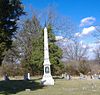
July 17, 1997 Georgetown Cemetery, 0.5 miles south of the junction of U.S. Route 25 and KY 1692
38°11′53″N 84°33′38″W / 38.19806°N 84.56056°WGeorgetown 18 Rhodin Coppage Spring House June 23, 1983 Off U.S. Route 25
38°14′44″N 84°33′37″W / 38.24556°N 84.56028°WGeorgetown 19 Newton Craig House and Penitentiary Buildings Complex July 19, 1984 U.S. Route 460
38°12′34″N 84°38′6″W / 38.20944°N 84.635°WGeorgetown 20 Craig-Johnson Mill Dam and Mill Sites June 10, 1975 Address Restricted Great Crossing 21 Dry Run Site December 5, 1985 Address Restricted Georgetown 22 Edge Hill Farm March 1, 1984 1661 Payne's Depot Pike
38°11′12″N 84°35′42″W / 38.18667°N 84.595°WGeorgetown 23 Elkwood January 20, 1978 Northwest of Georgetown
38°13′35″N 84°35′47″W / 38.22639°N 84.59639°WGeorgetown 24 Elmwood November 19, 1974 Northeast of Georgetown off U.S. Routes 227 and 460
38°13′33″N 84°30′51″W / 38.22583°N 84.51417°WGeorgetown 25 Ash Emison Quarters June 23, 1983 Off U.S. 25
38°15′34″N 84°33′23″W / 38.25944°N 84.55639°WDelaplain 26 First African Baptist Church and Parsonage 
March 1, 1984 209-211 W. Jefferson St.
38°12′45″N 84°33′40″W / 38.2125°N 84.56111°WGeorgetown 27 Matthew Flournoy House June 23, 1983 Off Crumbough Pike
38°11′46″N 84°29′26″W / 38.19611°N 84.49056°WCenterville 28 Flournoy-Nutter House July 28, 1977 East of Georgetown off KY 922
38°10′52″N 84°28′44″W / 38.18111°N 84.47889°WGeorgetown 29 James Gaines House November 7, 1976 South of Georgetown on Yarnallton Pike
38°9′15″N 84°33′58″W / 38.15417°N 84.56611°WGeorgetown 30 Garth School 
November 16, 1988 501 S. Hamilton St.
38°12′21″N 84°33′33″W / 38.20583°N 84.55917°WGeorgetown 31 John M. Garth House November 20, 1974 Southeast of Georgetown off Interstate 75
38°10′39″N 84°30′16″W / 38.1775°N 84.50444°WGeorgetown 32 Georgetown College Historic Buildings August 8, 1979 E. Jackson St.
38°12′25″N 84°33′17″W / 38.20694°N 84.55472°WGeorgetown 33 Georgetown East Main Street Residential District June 7, 1978 Irregular pattern along Main St. between Warrendale Ave. and Mulberry St.
38°12′34″N 84°33′15″W / 38.20944°N 84.55417°WGeorgetown 34 Giddings Hall, Georgetown College 
February 6, 1973 Giddings Dr. between Jackson and College Sts.
38°12′25″N 84°33′17″W / 38.20694°N 84.55472°WGeorgetown 35 Griffith House August 29, 1979 South of Interstate 64 on Moore's Mill Pike
38°9′34″N 84°37′43″W / 38.15944°N 84.62861°WMidway 36 Halley Place August 28, 1979 U.S. Route 62
38°8′43″N 84°37′4″W / 38.14528°N 84.61778°WGeorgetown 37 Matthew Henry House June 23, 1983 KY 922
38°12′19″N 84°28′55″W / 38.20528°N 84.48194°WCenterville 38 Dr. H. C. Herndon House April 10, 1980 West of Georgetown on KY 227
38°13′4″N 84°36′33″W / 38.21778°N 84.60917°WGeorgetown 39 Holy Trinity Episcopal Church 
October 30, 1973 S. Broadway and W. Clinton Sts.
38°12′28″N 84°33′38″W / 38.20778°N 84.56056°WGeorgetown 40 George W. Johnson Slave Quarters and Smokehouse November 19, 1974 Southwest of Georgetown off Ironworks Rd.
38°10′25″N 84°36′44″W / 38.17361°N 84.61222°WGeorgetown 41 James Johnson Quarters October 11, 1983 Off KY 227
38°12′48″N 84°36′50″W / 38.21333°N 84.61389°WGeorgetown 42 Leonidas Johnson House October 8, 1976 7 miles northwest of Georgetown on U.S. Route 227
38°14′44″N 84°39′35″W / 38.24556°N 84.65972°WGeorgetown 43 Johnson-Pence House November 20, 1978 West of Georgetown off U.S. Route 460
38°13′23″N 84°37′31″W / 38.22306°N 84.62528°WGeorgetown 44 Johnston-Jacobs House 
October 2, 1973 205 N. Hamilton St.
38°12′42″N 84°33′30″W / 38.21167°N 84.55833°WGeorgetown 45 Lane's Run Historic District January 12, 1984 Old Oxford Rd., U.S. Routes 62 and 460
38°13′55″N 84°31′7″W / 38.23194°N 84.51861°WGeorgetown 46 Leatherer-Lemon House July 20, 1977 Lemon's Mill Pike, 0.5 miles west of Newtown Pike
38°10′56″N 84°29′38″W / 38.18222°N 84.49389°WGeorgetown 47 William James-Trotter Lindsay House August 28, 1979 U.S. Route 62
38°8′15″N 84°37′43″W / 38.1375°N 84.62861°WGeorgetown 48 Longview October 25, 1973 About 4 miles west of Georgetown off U.S. Route 460
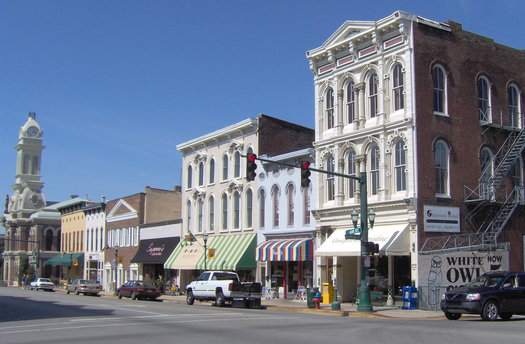
38°13′10″N 84°39′4″W / 38.21944°N 84.65111°WGeorgetown 49 Main Street Commercial District 
February 24, 1975 Both sides of E. Main St. from Mulberry to Broadway, southern side from Elley Alley to Broadway
38°15′49″N 84°33′25″W / 38.26361°N 84.55694°WGeorgetown 50 McFarland House October 15, 1973 510 Fountain Ave.
38°12′16″N 84°33′1″W / 38.20444°N 84.55028°WGeorgetown 51 Miller's Run Historic District November 15, 1978 Roughly bounded by Old Oxford Pike, KY 922, U.S. Route 460, and Miller's Run
38°14′14″N 84°29′44″W / 38.23722°N 84.49556°WOxford 52 John Andrew Miller House November 9, 1977 3 miles east of Georgetown off U.S. Route 460
38°13′21″N 84°29′58″W / 38.2225°N 84.49944°WGeorgetown 53 New Zion Historic District December 4, 2008 4972 Newtown Pike through 5200 Newtown Pike, and 103-135 New Zion Rd. Scott Extends into Fayette County 54 Lewis Nuckols House August 28, 1979 U.S. Route 421
38°7′53″N 84°37′25″W / 38.13139°N 84.62361°WGeorgetown 55 Osburn House April 11, 1973 4 miles north of Georgetown on U.S. Route 25
38°15′53″N 84°34′2″W / 38.26472°N 84.56722°WGeorgetown 56 Oxford Historic District September 11, 1979 Northeast of Georgetown at U.S. Route 62 and KY 922
38°16′8″N 84°30′4″W / 38.26889°N 84.50111°WGeorgetown 57 Joseph Patterson Quarters June 23, 1983 Off U.S. Route 421
38°9′0″N 84°38′20″W / 38.15°N 84.63889°WMidway 58 Asa Payne House August 28, 1979 U.S. Route 62
38°8′46″N 84°37′20″W / 38.14611°N 84.62222°WGeorgetown 59 Gen. John Payne House March 3, 1975 1.5 miles west of Georgetown on U.S. Route 460
38°12′47″N 84°35′22″W / 38.21306°N 84.58944°WGeorgetown 60 Payne-Desha House 
December 2, 1974 Kelly Ave.
38°12′45″N 84°33′48″W / 38.2125°N 84.56333°WGeorgetown 61 Levi Prewitt House November 1, 1974 South of Georgetown off Interstate 64
38°9′1″N 84°34′54″W / 38.15028°N 84.58167°WGeorgetown 62 Royal Spring Park 
April 2, 1973 Between Clinton and Jefferson Sts., west of Water, Broadway, and Georgetown Sts.
38°12′37″N 84°33′33″W / 38.21028°N 84.55917°WGeorgetown 63 St. Francis Mission at White Sulphur April 11, 1973 7 miles west of Georgetown on U.S. Route 460
38°12′28″N 84°41′50″W / 38.20778°N 84.69722°WGeorgetown 64 Robert Sanders House October 15, 1973 2 miles south of Georgetown on U.S. Route 25
38°10′11″N 84°33′29″W / 38.16972°N 84.55806°WGeorgetown 65 Scott County Courthouse 
September 28, 1972 E. Main and Broadway
38°12′36″N 84°33′35″W / 38.21°N 84.55972°WGeorgetown 66 Scott County Jail Complex 
September 6, 2002 117 N. Water St.
38°12′29″N 84°33′45″W / 38.20806°N 84.5625°WGeorgetown 67 Showalter House April 2, 1973 316 N. Hamilton St.
38°12′49″N 84°33′26″W / 38.21361°N 84.55722°WGeorgetown 68 Shropshire House April 2, 1973 355 E. Main St.
38°12′36″N 84°33′20″W / 38.21°N 84.55556°WGeorgetown 69 Dr. William Addison Smith House November 29, 1984 1589 Newton Pike
38°12′10″N 84°28′53″W / 38.20278°N 84.48139°WGeorgetown 70 Nelson and Clifton Rodes Smith House October 3, 1973 Northeast of Georgetown off Leesburg Pike
38°14′50″N 84°27′3″W / 38.24722°N 84.45083°WGeorgetown 71 South Broadway Neighborhood District December 19, 1991 Roughly Georgetown Cemetery, S. Broadway north to College St. and S. Hamilton St. from Clayton Ave. to College
38°12′9″N 84°33′38″W / 38.2025°N 84.56056°WGeorgetown 72 Henry Stevenson House August 28, 1979 U.S. Route 62
38°9′11″N 84°36′42″W / 38.15306°N 84.61167°WGeorgetown 73 Stone-Grant House January 11, 1974 East of Georgetown on E. Main St. extended
38°12′24″N 84°32′38″W / 38.20667°N 84.54389°WGeorgetown 74 John Suggett House June 23, 1983 U.S. Route 460
38°12′12″N 84°37′9″W / 38.20333°N 84.61917°WGeorgetown 75 William Suggett Agricultural and Industrial District November 16, 1988 Southwest of the junction of Cane Run Rd. and U.S. Route 460
38°12′18″N 84°36′46″W / 38.205°N 84.61278°WGeorgetown 76 Thomsons Mill Warehouse June 23, 1983 Off U.S. Route 460
38°13′6″N 84°34′29″W / 38.21833°N 84.57472°WGeorgetown 77 Ward Hall 
April 2, 1973 1.5 miles west of Georgetown on U.S. Route 460
38°12′23″N 84°35′21″W / 38.20639°N 84.58917°WGeorgetown 78 Weisenberger Mills and Related Buildings August 16, 1984 Off U.S. Route 421
38°7′34″N 84°38′13″W / 38.12611°N 84.63694°WMidway 79 West Main Street Historic District November 5, 1985 217-600 W. Main St.
38°12′39″N 84°33′59″W / 38.21083°N 84.56639°WGeorgetown 80 Charles Whitaker House June 23, 1983 Off Old Oxford Rd.
38°14′22″N 84°30′3″W / 38.23944°N 84.50083°WGeorgetown 81 Merritt Williams House February 28, 1979 Moore's Mill Pike at Can Run Pike
38°9′46″N 84°38′33″W / 38.16278°N 84.6425°WMidway See also
- List of National Historic Landmarks in Kentucky
- National Register of Historic Places listings in Kentucky
References
- ^ The latitude and longitude information provided in this table was derived originally from the National Register Information System, which has been found to be fairly accurate for about 99% of listings. For about 1% of NRIS original coordinates, experience has shown that one or both coordinates are typos or otherwise extremely far off; some corrections may have been made. A more subtle problem causes many locations to be off by up to 150 yards, depending on location in the country: most NRIS coordinates were derived from tracing out latitude and longitudes off of USGS topographical quadrant maps created under the North American Datum of 1927, which differs from the current, highly accurate WGS84 GPS system used by Google maps. Chicago is about right, but NRIS longitudes in Washington are higher by about 4.5 seconds, and are lower by about 2.0 seconds in Maine. Latitudes differ by about 1.0 second in Florida. Some locations in this table may have been corrected to current GPS standards.
- ^ "National Register of Historic Places: Weekly List Actions". National Park Service, United States Department of the Interior. Retrieved on November 10, 2011.
- ^ Numbers represent an ordering by significant words. Various colorings, defined here, differentiate National Historic Landmark sites and National Register of Historic Places Districts from other NRHP buildings, structures, sites or objects.
- ^ "National Register Information System". National Register of Historic Places. National Park Service. 2008-04-24. http://nrhp.focus.nps.gov/natreg/docs/All_Data.html.
U.S. National Register of Historic Places Topics Lists by states Alabama • Alaska • Arizona • Arkansas • California • Colorado • Connecticut • Delaware • Florida • Georgia • Hawaii • Idaho • Illinois • Indiana • Iowa • Kansas • Kentucky • Louisiana • Maine • Maryland • Massachusetts • Michigan • Minnesota • Mississippi • Missouri • Montana • Nebraska • Nevada • New Hampshire • New Jersey • New Mexico • New York • North Carolina • North Dakota • Ohio • Oklahoma • Oregon • Pennsylvania • Rhode Island • South Carolina • South Dakota • Tennessee • Texas • Utah • Vermont • Virginia • Washington • West Virginia • Wisconsin • WyomingLists by territories Lists by associated states Other Municipalities and communities of Scott County, Kentucky Cities 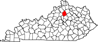 Categories:
- National Register of Historic Places in Scott County, Kentucky
-


Wikimedia Foundation. 2010.