- National Register of Historic Places listings in Sierra County, New Mexico
-
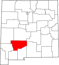 Location of Sierra County in New Mexico
This is a list of the National Register of Historic Places listings in Sierra County, New Mexico.
This is intended to be a complete list of the properties and districts on the National Register of Historic Places in Sierra County, New Mexico, United States. Latitude and longitude coordinates are provided for many National Register properties and districts; these locations may be seen together in a Google map.[1]
There are 29 properties and districts listed on the National Register in the county.
-
- This National Park Service list is complete through NPS recent listings posted November 10, 2011.[2]
Contents: Counties in New Mexico Bernalillo – Catron – Chaves – Cibola – Colfax – Curry – De Baca – Doña Ana – Eddy – Grant – Guadalupe – Harding – Hidalgo – Lea – Lincoln – Los Alamos – Luna – McKinley – Mora – Otero – Quay – Rio Arriba – Roosevelt – San Juan – San Miguel – Sandoval – Santa Fe – Sierra – Socorro – Taos – Torrance – Union – Valencia Current listings
[3] Landmark name [4] Image Date listed Location City or town Summary 1 Alert-Hatcher Building 
April 20, 1995 Southeastern corner of the junction of 2nd Ave. and Main St.
32°55′12″N 107°34′06″W / 32.92°N 107.568333°WHillsboro 2 Archeological Site No. LA1119 December 16, 1989 Address Restricted Truth or Consequences 3 Archeological Site No. LA49016 December 16, 1989 Address Restricted Truth or Consequences 4 Archeological Site No. LA49030 December 16, 1989 Address Restricted Truth or Consequences 5 Archeological Site No. LA50548 December 16, 1989 Address Restricted Truth or Consequences 6 Archeological Site No. LA517 December 16, 1989 Address Restricted Truth or Consequences 7 William H. Bucher House April 20, 1995 300 W. Main St.
32°55′11″N 107°34′11″W / 32.919722°N 107.569722°WHillsboro 8 Chambers Canyon Site (LA49028) December 16, 1989 Address Restricted Truth or Consequences 9 Elephant Butte Dam 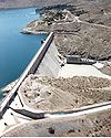
April 9, 1979 Northwest of Elephant Butte off State Road 51
33°09′17″N 107°11′31″W / 33.154722°N 107.191944°WElephant Butte 10 Elephant Butte Historic District February 10, 1997 Roughly along State Road 51 from the Elephant Butte Dam to Mescal Canyon and along State Road 52 from Ash Canyon to Long Ridge
33°08′56″N 107°11′27″W / 33.148889°N 107.190833°WElephant Butte 11 Fort McRae April 7, 2005 Address Restricted Elephant Butte 12 Hillsboro High School 
April 15, 1993 Southeastern corner of the junction of Elenora St. and 1st Ave.
32°55′10″N 107°34′01″W / 32.919444°N 107.566944°WHillsboro 13 Hillsboro Peak Lookout Tower and Cabin 
January 28, 1988 Gila National Forest
32°57′09″N 107°46′43″W / 32.9525°N 107.778611°WHillsboro 14 Horse Island Site (LA48996) May 16, 1988 Address Restricted Truth or Consequences 15 Hot Springs Bathhouse and Commercial Historic District in Truth or Consequences 
May 10, 2005 Roughly bounded by Post, Ban Patten, Pershing, and Main Sts.
33°07′40″N 107°15′17″W / 33.127778°N 107.254722°WTruth or Consequences 16 Kettle Top Butte Site (LA48995) May 16, 1988 Address Restricted Truth or Consequences 17 Longbottom Canyon Site (LA49033) December 16, 1989 Address Restricted Truth or Consequences 18 Meyers House April 20, 1995 Northern side of Main St. between 4th and 5th Aves.
32°55′12″N 107°34′15″W / 32.92°N 107.570833°WHillsboro 19 George Tambling and Ninette Stocker Miller House 
April 20, 1995 Southern side of Elenora St., west of Union Church
32°55′09″N 107°34′05″W / 32.919167°N 107.568056°WHillsboro 20 Monticello Point Archeological District May 16, 1988 Address Restricted Truth or Consequences 21 Palomas Narrows North (LA38755) December 16, 1989 Address Restricted Truth or Consequences 22 Palomas Narrows South (LA49007) December 16, 1989 Address Restricted Truth or Consequences 23 Percha Creek Bridge 
July 15, 1997 State Road 90 over Percha Creek
32°55′00″N 107°36′20″W / 32.916667°N 107.605556°WHillsboro 24 Percha Diversion Dam April 6, 1979 2 miles (3.2 km) northeast of Arrey
32°52′06″N 107°18′11″W / 32.868333°N 107.303056°WArrey 25 Will M. Robins House 
April 20, 1995 Southwestern corner of the junction of Main St. and 5th Ave.
32°55′10″N 107°34′18″W / 32.919444°N 107.571667°WHillsboro 26 Cornelius Sullivan House April 20, 1995 Southwestern corner of the junction of Elenora and 1st Ave.
32°55′10″N 107°34′04″W / 32.919444°N 107.567778°WHillsboro 27 Carrie Tingley Hospital Historic District 
March 15, 2005 992 Broadway
33°07′19″N 107°15′38″W / 33.121944°N 107.260556°WTruth or Consequences 28 US Post Office-Truth or Consequences Main 
February 23, 1990 400 Main St.
33°07′47″N 107°15′10″W / 33.129722°N 107.252778°WTruth or Consequences 29 John M. Webster House 
April 20, 1995 Southeastern corner of the junction of Main St. and 5th Ave.
32°55′10″N 107°34′16″W / 32.919444°N 107.571111°WHillsboro See also
- List of National Historic Landmarks in New Mexico
- National Register of Historic Places listings in New Mexico
References
- ^ The latitude and longitude information provided in this table was derived originally from the National Register Information System, which has been found to be fairly accurate for about 99% of listings. For about 1% of NRIS original coordinates, experience has shown that one or both coordinates are typos or otherwise extremely far off; some corrections may have been made. A more subtle problem causes many locations to be off by up to 150 yards, depending on location in the country: most NRIS coordinates were derived from tracing out latitude and longitudes off of USGS topographical quadrant maps created under the North American Datum of 1927, which differs from the current, highly accurate WGS84 GPS system used by Google maps. Chicago is about right, but NRIS longitudes in Washington are higher by about 4.5 seconds, and are lower by about 2.0 seconds in Maine. Latitudes differ by about 1.0 second in Florida. Some locations in this table may have been corrected to current GPS standards.
- ^ "National Register of Historic Places: Weekly List Actions". National Park Service, United States Department of the Interior. Retrieved on November 10, 2011.
- ^ Numbers represent an ordering by significant words. Various colorings, defined here, differentiate National Historic Landmark sites and National Register of Historic Places Districts from other NRHP buildings, structures, sites or objects.
- ^ "National Register Information System". National Register of Historic Places. National Park Service. . http://nrhp.focus.nps.gov/natreg/docs/All_Data.html.
U.S. National Register of Historic Places Topics Lists by states Alabama • Alaska • Arizona • Arkansas • California • Colorado • Connecticut • Delaware • Florida • Georgia • Hawaii • Idaho • Illinois • Indiana • Iowa • Kansas • Kentucky • Louisiana • Maine • Maryland • Massachusetts • Michigan • Minnesota • Mississippi • Missouri • Montana • Nebraska • Nevada • New Hampshire • New Jersey • New Mexico • New York • North Carolina • North Dakota • Ohio • Oklahoma • Oregon • Pennsylvania • Rhode Island • South Carolina • South Dakota • Tennessee • Texas • Utah • Vermont • Virginia • Washington • West Virginia • Wisconsin • WyomingLists by territories Lists by associated states Other Municipalities and communities of Sierra County, New Mexico Cities 
Villages Unincorporated
communitiesGhost towns Chloride | Cuchillo | Hermosa | Lake Valley
Categories:- National Register of Historic Places in New Mexico by county
- Sierra County, New Mexico
- History of Sierra County, New Mexico
-


Wikimedia Foundation. 2010.