- National Register of Historic Places listings in Sullivan County, New Hampshire
-
 Location of Sullivan County in New Hampshire
This is a list of the National Register of Historic Places listings in Sullivan County, New Hampshire.
This is intended to be a complete list of the properties and districts on the National Register of Historic Places in Sullivan County, New Hampshire, United States. Latitude and longitude coordinates are provided for many National Register properties and districts; these locations may be seen together in a Google map.[1]
There are 65 properties and districts listed on the National Register in the county, including 2 National Historic Landmarks.
Contents: Counties in New Hampshire Belknap - Carroll - Cheshire - Coos - Grafton - Hillsborough - Merrimack - Rockingham - Strafford - Sullivan -
- This National Park Service list is complete through NPS recent listings posted November 10, 2011.[2]
Current listings
[3] Landmark name [4] Image Date listed Location City or town Summary 1 Acworth Congregational Church June 13, 1975 Northern end of town common
43°13′08″N 72°17′38″W / 43.218889°N 72.293889°WAcworth 2 Acworth Silsby Library December 8, 1983 Intersection of Cold Pond and Lynn Hill Rds.
43°13′06″N 72°17′33″W / 43.218333°N 72.2925°WAcworth 3 Backside Inn June 21, 1985 Brook Rd.
43°18′47″N 72°06′51″W / 43.313056°N 72.114167°WGoshen 4 Blow-Me-Down Covered Bridge May 19, 1978 South of Plainfield off NH 12A
43°31′02″N 72°22′28″W / 43.517222°N 72.374444°WPlainfield Over Blow-me-down Brook 5 Blow-Me-Down Grange March 2, 2001 1071 NH 12A
43°32′01″N 72°21′24″W / 43.533611°N 72.356667°WPlainfield 6 Burford House June 21, 1985 NH 10
43°17′59″N 72°08′55″W / 43.299722°N 72.148611°WGoshen 7 Central Business District 
February 21, 1978 Roughly bounded by Crescent, Broad, Pine, and Franklin Sts.
43°22′17″N 72°20′14″W / 43.371389°N 72.337222°WClaremont 8 Charlestown Main Street Historic District June 10, 1987 Main St.
43°14′06″N 72°25′26″W / 43.235°N 72.423889°WCharlestown 9 Charlestown Town Hall March 15, 1984 North of Summer St., off Main St.
43°14′09″N 72°25′26″W / 43.235833°N 72.423889°WCharlestown 10 Salmon P. Chase Birthplace May 15, 1975 8 mi (13 km) north of Claremont
43°27′18″N 72°23′14″W / 43.455°N 72.387222°WCornish Birthplace and childhood home of Salmon P. Chase. 11 Claremont City Hall 
April 26, 1973 Tremont Sq.
43°22′21″N 72°20′15″W / 43.3725°N 72.3375°WClaremont 12 Claremont Warehouse No. 34 February 28, 1979 43 River St.
43°22′32″N 72°20′42″W / 43.375556°N 72.345°WClaremont 13 Cold River Bridge May 17, 1973 East of Langdon on McDermott Rd
43°10′13″N 72°20′46″W / 43.170278°N 72.346111°WLangdon Over Cold River 14 Cornish–Windsor Covered Bridge 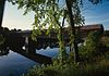
November 21, 1976 West of Cornish City
43°28′26″N 72°23′01″W / 43.473889°N 72.383611°WCornish Over Connecticut River, connecting to Windsor, Vermont 15 Cote House June 21, 1985 Goshen Center Rd.
43°17′44″N 72°07′03″W / 43.295556°N 72.1175°WGoshen 16 Covit House June 21, 1985 Goshen Center Rd.
43°17′43″N 72°06′54″W / 43.295278°N 72.115°WGoshen 17 David Dexter House November 29, 1979 Dexter Heights
43°22′37″N 72°20′16″W / 43.376944°N 72.337778°WClaremont 18 Dingleton Hill Covered Bridge November 8, 1978 Off NH 12A
43°27′51″N 72°22′09″W / 43.464167°N 72.369167°WCornish Mills Over Mill Brook 19 Durham House June 21, 1985 Ball Park Rd.
43°16′32″N 72°08′03″W / 43.275556°N 72.134167°WGoshen 20 English Church February 1, 1980 Old Church Rd.
43°22′59″N 72°22′18″W / 43.383056°N 72.371667°WClaremont 21 Farwell School December 6, 1990 NH 12A south of Hope Hill Cemetery
43°18′34″N 72°23′19″W / 43.309444°N 72.388611°WCharlestown 22 First Baptist Church of Cornish February 14, 1978 Meriden Stage Rd. and NH 120
43°29′54″N 72°16′48″W / 43.498333°N 72.28°WCornish Flat 23 First Universalist Chapel December 12, 2006 3 2nd New Hampshire Turnpike
43°13′39″N 72°10′43″W / 43.2275°N 72.178611°WLempster 24 Garber House June 21, 1985 Willey Hill Rd.
43°16′43″N 72°07′56″W / 43.278611°N 72.132222°WGoshen 25 Giffin House June 21, 1985 NH 10
43°17′56″N 72°08′53″W / 43.298889°N 72.148056°WGoshen 26 Capt. John Gunnison House December 19, 1979 East of Goshen on Goshen Center Rd.
43°17′42″N 72°07′39″W / 43.295°N 72.1275°WGoshen 27 Hunter Archeological Site June 7, 1976 Address Restricted Claremont 28 Janicke House June 21, 1985 Goshen Center Rd.
43°17′47″N 72°06′55″W / 43.296389°N 72.115278°WGoshen 29 Kenyon Bridge 
May 22, 1978 Off NH 12A at Mill Brook and Town House Rd.
43°28′00″N 72°21′03″W / 43.466667°N 72.350833°WCornish City 30 Knights-Morey House June 21, 1985 Province Rd.
43°19′26″N 72°07′24″W / 43.323889°N 72.123333°WGoshen 31 Lear House June 21, 1985 Province Rd.
43°19′48″N 72°06′16″W / 43.33°N 72.104444°WGoshen 32 Lempster Meetinghouse September 8, 1980 Lempster St.
43°14′20″N 72°12′38″W / 43.238889°N 72.210556°WLempster 33 Little Red School House 1835 District No. 7 December 1, 1980 South of Newport on NH 10
43°20′08″N 72°10′06″W / 43.335556°N 72.168333°WNewport 34 Lower Village District February 21, 1978 Along Central St. and Main St. on both sides of the Sugar River
43°22′29″N 72°20′34″W / 43.374722°N 72.342778°WClaremont 35 Meriden Bridge August 27, 1980 Northwest of Meriden
43°33′12″N 72°16′00″W / 43.553333°N 72.266667°WMeriden Over Bloods Brook 36 Monadnock Mills 
February 15, 1979 Broad, Water, Crescent Sts., and Mill Rd.
43°22′26″N 72°20′20″W / 43.373869°N 72.338909°WClaremont 37 Mothers' and Daughters' Club House March 11, 1982 Main St.
43°32′10″N 72°21′19″W / 43.536111°N 72.355278°WPlainfield 38 Nettleton House November 16, 1977 26-30 Central St.
43°21′51″N 72°10′19″W / 43.364167°N 72.171944°WNewport 39 Newport Downtown Historic District 
June 6, 1985 Main St. roughly bounded by Depot, Sunapee, Central and West Sts.
43°21′48″N 72°10′20″W / 43.363333°N 72.172222°WNewport 40 North Charlestown Historic District June 9, 2005 River Rd.
43°18′33″N 72°23′18″W / 43.309167°N 72.388333°WCharlestown 41 Pier Bridge June 10, 1975 3 mi (4.8 km) west of Newport on Chandler Rd. over the Sugar River
43°21′43″N 72°14′31″W / 43.361944°N 72.241944°WNewport 42 Pike House June 21, 1985 NH 10
43°18′01″N 72°08′52″W / 43.300278°N 72.147778°WGoshen 43 Plainfield Town Hall June 6, 1985 NH 12A
43°32′08″N 72°21′17″W / 43.535556°N 72.354722°WPlainfield 44 Prentiss Bridge May 24, 1973 South of Langdon off Old Cheshire Turnpike
43°09′11″N 72°23′38″W / 43.153056°N 72.393889°WLangdon Over Great Brook 45 Protectworth Tavern November 25, 1980 NH 4A
43°30′37″N 72°02′03″W / 43.510278°N 72.034167°WSpringfield 46 Purnell House June 21, 1985 NH 10
43°18′31″N 72°09′33″W / 43.308611°N 72.159167°WGoshen 47 Isaac Reed House July 19, 1978 30-34 Main St.
43°21′51″N 72°10′21″W / 43.364167°N 72.1725°WNewport 48 Richards Free Library September 7, 1984 58 N. Main St.
43°22′00″N 72°10′34″W / 43.366667°N 72.176111°WNewport 49 William Rossiter House May 25, 1979 11 Mulberry St.
43°22′20″N 72°20′41″W / 43.372222°N 72.344722°WClaremont 50 Saint-Gaudens National Historic Site 
October 15, 1966 South of Plainfield off NH 12A
43°30′2″N 72°22′8″W / 43.50056°N 72.36889°WCornish Home and studio of American sculptor Augustus Saint-Gaudens; a National Historic Landmark and National Historic Site 51 Scranton House June 21, 1985 Brook Rd.
43°18′42″N 72°07′49″W / 43.311667°N 72.130278°WGoshen 52 Seavey House June 21, 1985 NH 10
43°17′53″N 72°08′50″W / 43.298056°N 72.147222°WGoshen 53 South Congregational Church 
March 30, 1989 58 S. Main St.
43°21′40″N 72°10′14″W / 43.361111°N 72.170556°WNewport 54 Springfield Town Hall and Howard Memorial Methodist Church June 5, 1986 Four Corners Rd. southeast of New London Rd.
43°29′43″N 72°02′55″W / 43.495278°N 72.048611°WSpringfield 55 Louis St. Gaudens House and Studio November 15, 1972 Dingleton Hill and Whitten Rds.
43°30′01″N 72°20′51″W / 43.500278°N 72.3475°WCornish 56 Stelljes House June 21, 1985 NH 31
43°15′37″N 72°06′58″W / 43.260278°N 72.116111°WGoshen 57 Sullivan County Courthouse June 25, 1973 Court Sq.
43°21′52″N 72°10′21″W / 43.364444°N 72.1725°WNewport 58 Town Hall and Courthouse February 29, 1980 20 Main St.
43°21′51″N 72°10′21″W / 43.364167°N 72.1725°WNewport 59 Trinity Church July 31, 1978 West of Cornish Mills on NH 12A
43°28′01″N 72°23′06″W / 43.466944°N 72.385°WCornish Mills 60 Unity Town Hall June 6, 1985 Off Unity Rd. and the Old New Hampshire Turnpike
43°18′12″N 72°15′42″W / 43.303333°N 72.261667°WUnity 61 Washington Common Historic District 
March 14, 1986 Junction of Half Moon Pond and Millen Pond Rds.
43°10′34″N 72°05′47″W / 43.176111°N 72.096389°WWashington 62 Welcome Acres June 21, 1985 NH 10
43°18′16″N 72°09′14″W / 43.304444°N 72.153889°WGoshen 63 Williamson House June 21, 1985 Messer Rd.
43°19′59″N 72°06′50″W / 43.333056°N 72.113889°WGoshen 64 Windswept Acres-Powers House June 21, 1985 NH 31
43°15′30″N 72°07′06″W / 43.258333°N 72.118333°WGoshen 65 Wright's Bridge 
June 10, 1975 East of Claremont on Chandler Rd. over the Sugar River
43°21′33″N 72°15′34″W / 43.359167°N 72.259444°WNewport See also
- List of National Historic Landmarks in New Hampshire
- National Register of Historic Places listings in New Hampshire
References
- ^ The latitude and longitude information provided in this table was derived originally from the National Register Information System, which has been found to be fairly accurate for about 99% of listings. For about 1% of NRIS original coordinates, experience has shown that one or both coordinates are typos or otherwise extremely far off; some corrections may have been made. A more subtle problem causes many locations to be off by up to 150 yards, depending on location in the country: most NRIS coordinates were derived from tracing out latitude and longitudes off of USGS topographical quadrant maps created under the North American Datum of 1927, which differs from the current, highly accurate WGS84 GPS system used by Google maps. Chicago is about right, but NRIS longitudes in Washington are higher by about 4.5 seconds, and are lower by about 2.0 seconds in Maine. Latitudes differ by about 1.0 second in Florida. Some locations in this table may have been corrected to current GPS standards.
- ^ "National Register of Historic Places: Weekly List Actions". National Park Service, United States Department of the Interior. Retrieved on November 10, 2011.
- ^ Numbers represent an ordering by significant words. Various colorings, defined here, differentiate National Historic Landmark sites and National Register of Historic Places Districts from other NRHP buildings, structures, sites or objects.
- ^ "National Register Information System". National Register of Historic Places. National Park Service. . http://nrhp.focus.nps.gov/natreg/docs/All_Data.html.
U.S. National Register of Historic Places Topics Lists by states Alabama • Alaska • Arizona • Arkansas • California • Colorado • Connecticut • Delaware • Florida • Georgia • Hawaii • Idaho • Illinois • Indiana • Iowa • Kansas • Kentucky • Louisiana • Maine • Maryland • Massachusetts • Michigan • Minnesota • Mississippi • Missouri • Montana • Nebraska • Nevada • New Hampshire • New Jersey • New Mexico • New York • North Carolina • North Dakota • Ohio • Oklahoma • Oregon • Pennsylvania • Rhode Island • South Carolina • South Dakota • Tennessee • Texas • Utah • Vermont • Virginia • Washington • West Virginia • Wisconsin • WyomingLists by territories Lists by associated states Other Municipalities and communities of Sullivan County, New Hampshire City 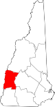
Towns Acworth | Charlestown | Cornish | Croydon | Goshen | Grantham | Langdon | Lempster | Newport | Plainfield | Springfield | Sunapee | Unity | Washington
Villages Balloch | Cornish Flat | East Lempster | Georges Mills | Guild | Meriden
Categories:- National Register of Historic Places in New Hampshire by county
- Sullivan County, New Hampshire
-


Wikimedia Foundation. 2010.