- National Register of Historic Places listings in Ventura County, California
-
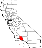
This List of Registered Historic Places in Ventura County, California is intended to describe all 34 U.S. Registered Historic Places in the county. The locations of RHPs whose latitude and longitude coordinates are included below, may be seen in a Google map by clicking on "Map of all coordinates".[1]
See List of Registered Historic Places in California for other counties.
-
- This National Park Service list is complete through NPS recent listings posted November 10, 2011.[2]
[3] Landmark name [4] Image Date listed Location City or town Summary 1 Anacapa Island Archeological District September 12, 1979 Address Restricted Port Hueneme 2 Anacapa Island Light Station 
September 3, 1991 Anacapa Island, Channel Islands National Park
34°00′56″N 119°21′39″W / 34.015556°N 119.360833°WOxnard 3 Elizabeth Bard Memorial Hospital 
November 11, 1977 121 N. Fir St.
34°16′56″N 119°17′18″W / 34.282222°N 119.288333°WVentura 4 Bardsdale Methodist Episcopal Church August 28, 1986 1418 Bardsdale Ave.
34°22′17″N 118°55′55″W / 34.371389°N 118.931944°WFillmore P.O. Bardsdale, California 5 Berylwood September 15, 1977 Ventura Rd.
34°09′29″N 119°11′45″W / 34.158056°N 119.195833°WPort Hueneme Bard family's 62-acre (250,000 m2) estate; leased by the Navy during World War II and acquired by the government in 1951 6 Burro Flats Painted Cave May 5, 1976 Address Restricted Bell Canyon 7 Calleguas Creek Site May 19, 1976 Address Restricted Oxnard 8 Camarillo Ranch House 
February 20, 2003 201 Camarillo Ranch Rd.
34°13′05″N 119°01′02″W / 34.218056°N 119.017222°WCamarillo Fifteen-room house built in 1892 by the Camarillo family, after whom the City of Camarillo is named 9 Colony House 
September 18, 1978 137 Strathearn Pl.
34°16′30″N 118°48′04″W / 34.275°N 118.801111°WSimi Valley Kit house on display at historical park with Simi Adobe and Strathearn House 10 Dudley House May 12, 1977 4085 Telegraph Rd.
34°16′34″N 119°14′20″W / 34.276111°N 119.238889°WVentura 11 Ebell Club of Santa Paula July 20, 1989 125 S. Seventh St.
34°21′06″N 119°03′51″W / 34.351667°N 119.064167°WSanta Paula 12 George Washington Faulkner House April 25, 1991 14292 W. Telegraph Rd.
34°19′32″N 119°06′18″W / 34.325556°N 119.105°WSanta Paula 13 Feraud General Merchandise Store 
January 23, 1986 2 and 12 W. Main St.
34°16′51″N 119°18′00″W / 34.280833°N 119.3°WVentura Historic bakery, now a bar 14 First Baptist Church of Ventura July 3, 2009 101 S. Laurel St.
34°16′46″N 119°17′09″W / 34.279311°N 119.285714°WVentura 15 Emmanuel Franz House 
June 25, 1982 31 N. Oak St.
34°16′52″N 119°17′38″W / 34.281111°N 119.293889°WVentura 16 Glen Tavern Hotel July 26, 1984 134 N. Mill St.
34°21′18″N 119°03′40″W / 34.355°N 119.061111°WSanta Paula 17 Thomas Gould, Jr. House December 23, 2005 402 Lynn Dr.
34°16′47″N 119°14′58″W / 34.279722°N 119.249444°WVentura 18 Grand Union Hotel 
December 30, 1975 51 Ventu Park Rd.
34°10′41″N 118°54′41″W / 34.178056°N 118.911389°WNewbury Park Originally built in 1876, the structure was destroyed by fire in 1970. It was rebuilt and opened in 1976 as a historical museum, known in recent years as the Stagecoach Inn. 19 Grandma Prisbrey's Bottle Village 
October 25, 1996 4595 Cochran St.
34°16′44″N 118°42′14″W / 34.278889°N 118.703889°WSimi Valley Folk art assemblage made out of bottles and other found objects begun in 1956 by Tressa Prisbrey 20 Joel McCrea Ranch 
April 18, 1997 4500 N. Moorpark Rd.
34°14′35″N 118°51′24″W / 34.243056°N 118.856667°WThousand Oaks Working ranch run by actor Joel McCrea from the 1930s to the 1970s 21 Mission San Buenaventura and Mission Compound Site 
April 10, 1975 Bounded by Poli St., Ventura and Santa Clara Aves., and Palm St.
34°16′50″N 119°17′52″W / 34.280556°N 119.297778°WVentura 22 Olivas Adobe 
July 24, 1979 4200 Olivas Park Dr.
34°14′40″N 119°14′28″W / 34.244444°N 119.241111°WVentura The only early two-story adobe in the Santa Clara River Valley; small one-story adobe built in 1837 was expanded in 1849 by Don Raimundo Olivas 23 Oxnard Public Library 
July 27, 1971 424 S. C St.
34°11′54″N 119°10′48″W / 34.198333°N 119.18°WOxnard Former Carnegie library converted into an art museum, now known as Carnegie Art Museum 24 Henry T. Oxnard Historic District 
February 5, 1999 F and G Sts., between Palm and 5th Sts.
34°12′01″N 119°11′11″W / 34.200278°N 119.186389°WOxnard District of historic homes located near downtown Oxnard 25 Charles M. Pratt House June 14, 2002 1330 Foothill Rd.
34°27′43″N 119°15′18″W / 34.461944°N 119.255°WOjai 26 Rancho Camulos 
November 1, 1996 5164 E. Telegraph Rd.
34°24′18″N 118°45′20″W / 34.405°N 118.755556°WPiru 27 St. Thomas Aquinas Chapel June 29, 1995 130 W. Ojai Ave.
34°26′53″N 119°14′49″W / 34.448056°N 119.246944°WOjai 28 San Buenaventura Mission Aqueduct 
March 7, 1975 234 Canada Larga Rd.
34°20′31″N 119°17′23″W / 34.341944°N 119.289722°WVentura Ruins of 7 mile (11 km) aqueduct built by Native Americans to bring water from the Ventura River to the San Buenaventura Mission 29 San Miguel Chapel Site July 20, 1978 Address Restricted Ventura 30 Santa Paula Hardware Company Block-Union Oil Company 
August 14, 1986 1003 E. Main St.
34°21′15″N 119°03′32″W / 34.354167°N 119.058889°WSanta Paula 31 Simi Adobe-Strathearn House 
May 19, 1978 137 Strathearn Pl.
34°16′30″N 118°48′01″W / 34.275°N 118.800278°WSimi Valley Old adobe and Victorian house built in 1892 that were the homestead of the Ranch Simi 32 SS WINFIELD SCOTT (Steamship) 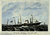
September 12, 1988 Address Restricted Anacapa Island Shipwreck. 33 Ventura County Courthouse 
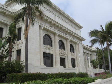
August 19, 1971 501 Poli St.
34°16′57″N 119°17′32″W / 34.2825°N 119.292222°WVentura 34 Ventura Theatre 
December 29, 1986 26 S. Chestnut
34°16′50″N 119°17′26″W / 34.280556°N 119.290556°WVentura Historic theater now a popular music venue in downtown Ventura 35 Women's Improvement Club of Hueneme 
August 21, 1989 239 E. Scott St.
34°08′58″N 119°11′48″W / 34.149444°N 119.196667°WPort Hueneme See also
- National Register of Historic Places listings in California
- List of National Historic Landmarks in California
References
- ^ The latitude and longitude information provided is primarily from the National Register Information System, and has been found to be fairly accurate for about 99% of listings. For 1%, the location info may be way off. We seek to correct the coordinate information wherever it is found to be erroneous. Please leave a note in the Discussion page for this article if you believe any specific location is incorrect.
- ^ "National Register of Historic Places: Weekly List Actions". National Park Service, United States Department of the Interior. Retrieved on November 10, 2011.
- ^ Numbers represent an ordering by significant words. Various colorings, defined here, differentiate National Historic Landmark sites and National Register of Historic Places Districts from other NRHP buildings, structures, sites or objects.
- ^ "National Register Information System". National Register of Historic Places. National Park Service. . http://nrhp.focus.nps.gov/natreg/docs/All_Data.html.
U.S. National Register of Historic Places Topics Lists by states Alabama • Alaska • Arizona • Arkansas • California • Colorado • Connecticut • Delaware • Florida • Georgia • Hawaii • Idaho • Illinois • Indiana • Iowa • Kansas • Kentucky • Louisiana • Maine • Maryland • Massachusetts • Michigan • Minnesota • Mississippi • Missouri • Montana • Nebraska • Nevada • New Hampshire • New Jersey • New Mexico • New York • North Carolina • North Dakota • Ohio • Oklahoma • Oregon • Pennsylvania • Rhode Island • South Carolina • South Dakota • Tennessee • Texas • Utah • Vermont • Virginia • Washington • West Virginia • Wisconsin • WyomingLists by territories Lists by associated states Other  Category:National Register of Historic Places •
  Portal:National Register of Historic Places
Municipalities and communities of Ventura County, California County seat: Ventura Cities Camarillo | Fillmore | Moorpark | Ojai | Oxnard | Port Hueneme | Santa Paula | Simi Valley | Thousand Oaks | Ventura
CDPs Bell Canyon | Casa Conejo | Channel Islands Beach | El Rio | Lake Sherwood | Meiners Oaks | Mira Monte | Oak Park | Oak View | Piru | Santa Rosa Valley | Santa Susana | Saticoy
Unincorporated
communitiesBardsdale | Buckhorn | Casitas Springs | Dulah | Faria | La Conchita | Newbury Park | Point Mugu | Sea Cliff | Somis | Upper Ojai
Categories:- History of Ventura County, California
- Ventura County, California
- National Register of Historic Places in California by county
- Lists of National Register of Historic Places in California
-


Wikimedia Foundation. 2010.