- National Register of Historic Places listings in Washtenaw County, Michigan
-
List of Registered Historic Places in Washtenaw County, Michigan.
-
- This National Park Service list is complete through NPS recent listings posted November 10, 2011.[1]
[2] Landmark name [3] Image Date listed Location City or town Summary 1 William Anderson House 
August 19, 1982 2301 Packard Rd.
42°15′16″N 83°43′30″W / 42.254444°N 83.725°WAnn Arbor 2 Ann Arbor Central Fire Station 
January 13, 1972 Corner of 5th Ave. and Huron St.
42°16′54″N 83°44′47″W / 42.281667°N 83.746389°WAnn Arbor Now occupied by the Ann Arbor Hands-On Museum 3 Joseph Annin House 
October 10, 1985 218 Monroe St.
42°09′42″N 83°47′04″W / 42.161667°N 83.784444°WSaline 4 Bell Road Bridge 
November 29, 1996 Bell Rd. at the Huron River, Dexter Township
42°24′05″N 83°54′32″W / 42.401389°N 83.908889°WPinckney 5 Bell-Spalding House 
December 28, 1990 2117 Washtenaw Ave.
42°15′55″N 83°43′05″W / 42.265278°N 83.718056°WAnn Arbor 6 Henry Bennett House 
March 1, 1973 312 S. Division St.
42°16′44″N 83°44′40″W / 42.278889°N 83.744444°WAnn Arbor 7 Brinkerhoff-Becker House 
July 8, 1982 601 W. Forest Ave.
42°14′51″N 83°37′15″W / 42.2475°N 83.620833°WYpsilanti 8 Chelsea Commercial Historic District 
February 22, 2011 Main St. and adjacent sections of Middle, Park, Jackson, East, and Orchard Sts.
42°19′05″N 84°01′13″W / 42.318056°N 84.020278°WChelsea 9 Zalmon Church House 
October 10, 1985 113 N. Ann Arbor
42°10′02″N 83°46′55″W / 42.167222°N 83.781944°WSaline 10 William H. Davenport House 
March 3, 1975 300 E. Michigan Ave.
42°10′11″N 83°46′31″W / 42.169722°N 83.775278°WSaline 11 Delhi Bridge 
September 4, 2008 E. Delhi Rd. over Huron River
42°20′01″N 83°48′33″W / 42.333725°N 83.809089°WScio 12 Delta Upsilon Fraternity House 
November 29, 1995 1331 Hill St.
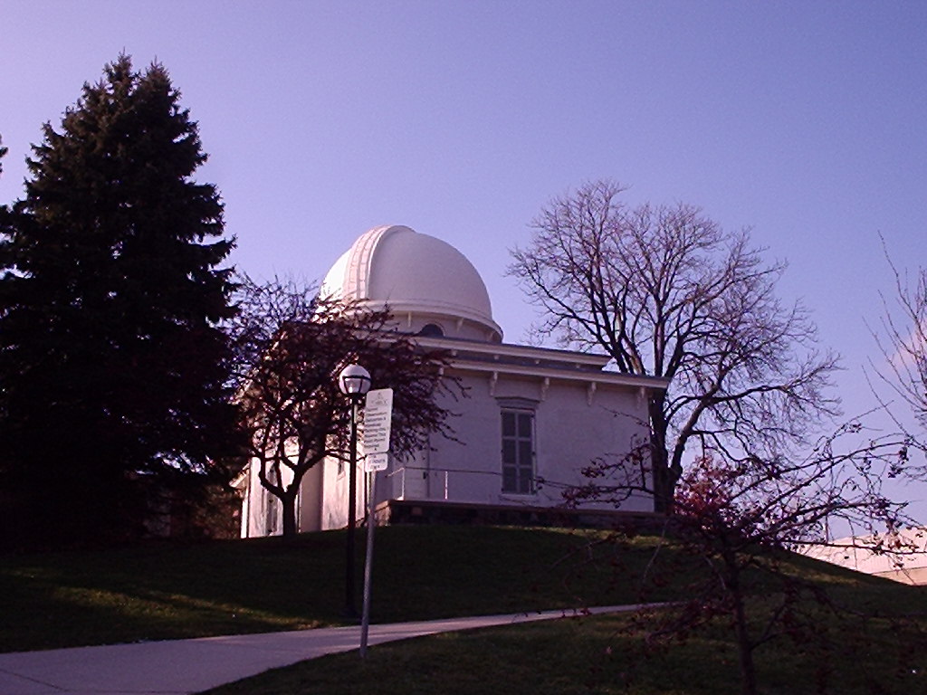
42°16′20″N 83°43′56″W / 42.272222°N 83.732222°WAnn Arbor 13 Detroit Observatory 
September 20, 1973 Observatory and Ann Sts.
42°16′54″N 83°43′54″W / 42.281667°N 83.731667°WAnn Arbor 14 Detroit, Hillsdale and Indiana Railroad-Saline Depot 
June 17, 1994 402 N. Ann Arbor St.
42°10′18″N 83°47′00″W / 42.171667°N 83.783333°WSaline 15 Nathan B. Devereaux Octagon House 
April 2, 2003 66425 Eight Mile Rd.
42°25′46″N 83°41′56″W / 42.429444°N 83.698889°WNorthfield Township 16 Dixboro United Methodist Church 
March 16, 1972 5221 Church St.
42°18′48″N 83°39′21″W / 42.313333°N 83.655833°WDixboro 17 Thomas Earl House 
June 25, 1992 415 N. Main St.
42°17′03″N 83°44′55″W / 42.284167°N 83.748611°WAnn Arbor 18 East Michigan Avenue Historic District 
October 10, 1985 300-321 E. Michigan Ave., 99-103 Maple St., and 217, 300 and 302 E. Henry
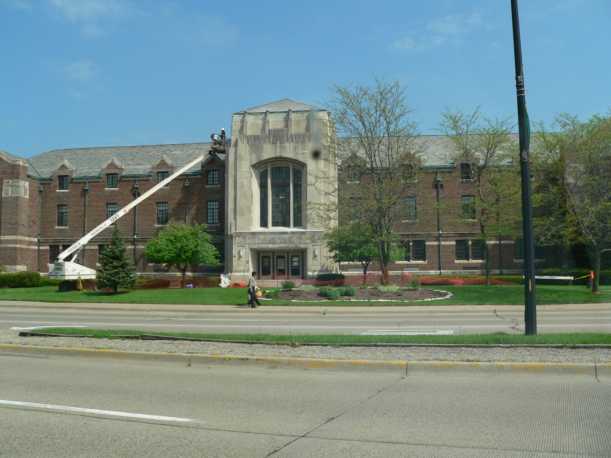
42°10′09″N 83°46′32″W / 42.169167°N 83.775556°WSaline 19 Eastern Michigan University Historic District 
October 4, 1984 Cross St., Washtenaw and Forest Aves.
42°14′47″N 83°37′29″W / 42.246389°N 83.624722°WYpsilanti 20 First National Bank Building 
November 24, 1982 201 S. Main St.
42°16′48″N 83°44′54″W / 42.28°N 83.748333°WAnn Arbor 21 Jortin Forbes House 
October 10, 1985 211 N. Ann Arbor St.
42°10′05″N 83°46′57″W / 42.168056°N 83.7825°WSaline 22 Fountain-Bessac House 
September 29, 1988 102 W. Main St.
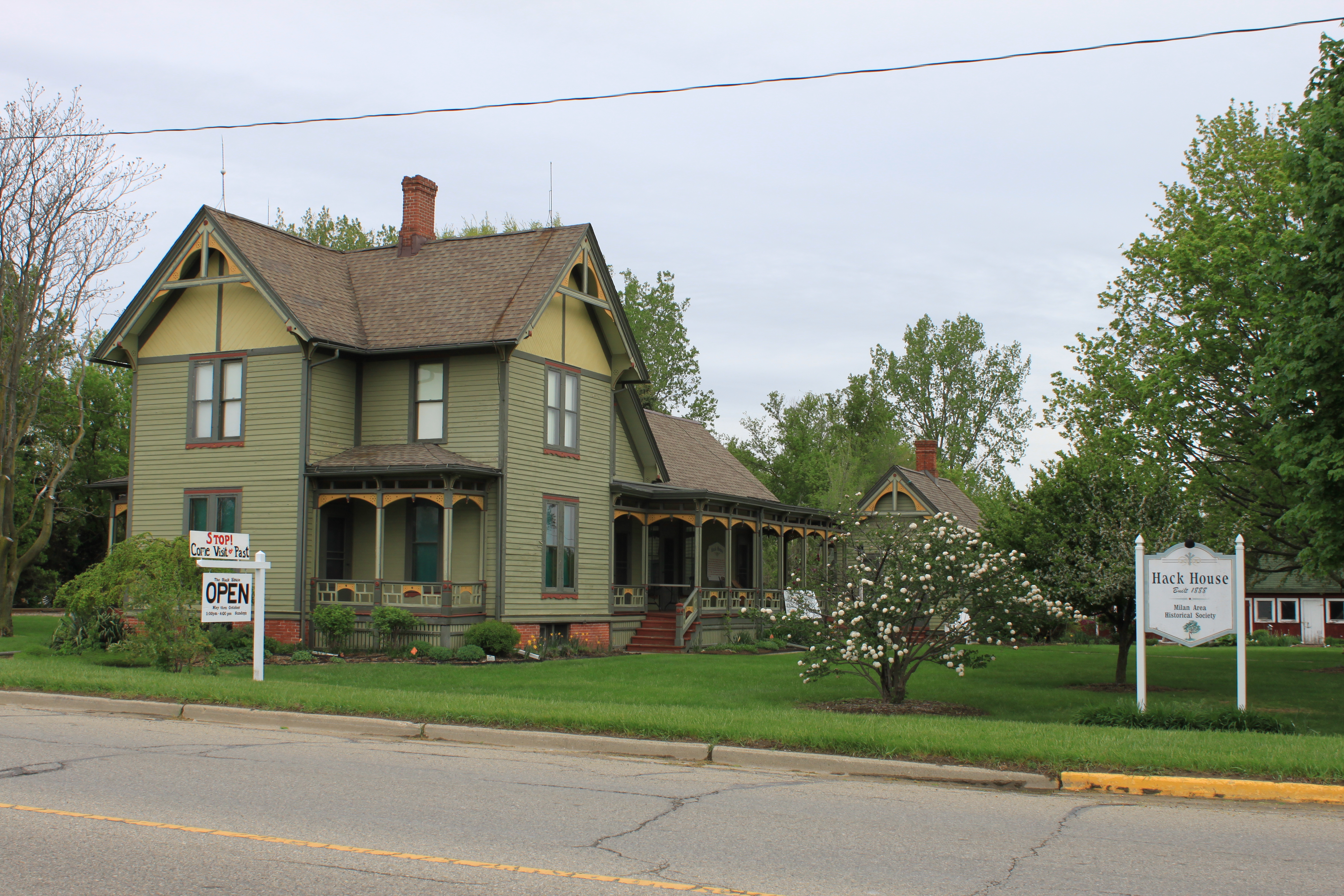
42°08′58″N 84°02′26″W / 42.149444°N 84.040556°WManchester 23 Friend-Hack House 
April 25, 1991 775 County St.
42°05′05″N 83°40′15″W / 42.084722°N 83.670833°WMilan 24 Henry S. Frieze House 
November 15, 1972 1547 Washtenaw Ave.
42°16′22″N 83°43′41″W / 42.272778°N 83.728056°WAnn Arbor 25 Germania Building Complex 
March 10, 1983 119-123 W. Washington St. and 209-211 Ashley St.
42°16′49″N 83°44′58″W / 42.280278°N 83.749444°WAnn Arbor 26 Goodyear Block 
August 5, 1993 138 E. Main St.
42°09′00″N 84°02′21″W / 42.15°N 84.039167°WManchester 27 Gordon Hall 
November 9, 1972 8347 Island Lake Rd.
42°20′25″N 83°53′55″W / 42.340278°N 83.898611°WDexter 28 Arnold and Gertrude Goss House 
May 17, 2006 3215 W. Dobson Place
42°17′26″N 83°41′56″W / 42.290556°N 83.698889°WAnn Arbor 29 Charles Guthard House 
October 10, 1985 211 E. Michigan Ave.
42°10′07″N 83°46′41″W / 42.168611°N 83.778056°WSaline 30 Harris Hall 
April 22, 1982 617 East Huron St.
42°16′53″N 83°44′28″W / 42.281389°N 83.741111°WAnn Arbor 31 Jacob Hoffstetter House 
March 19, 1982 322 E. Washington St.
42°16′48″N 83°44′42″W / 42.28°N 83.745°WAnn Arbor 32 Kellogg-Warden House 
July 22, 1994 500 N. Main St.
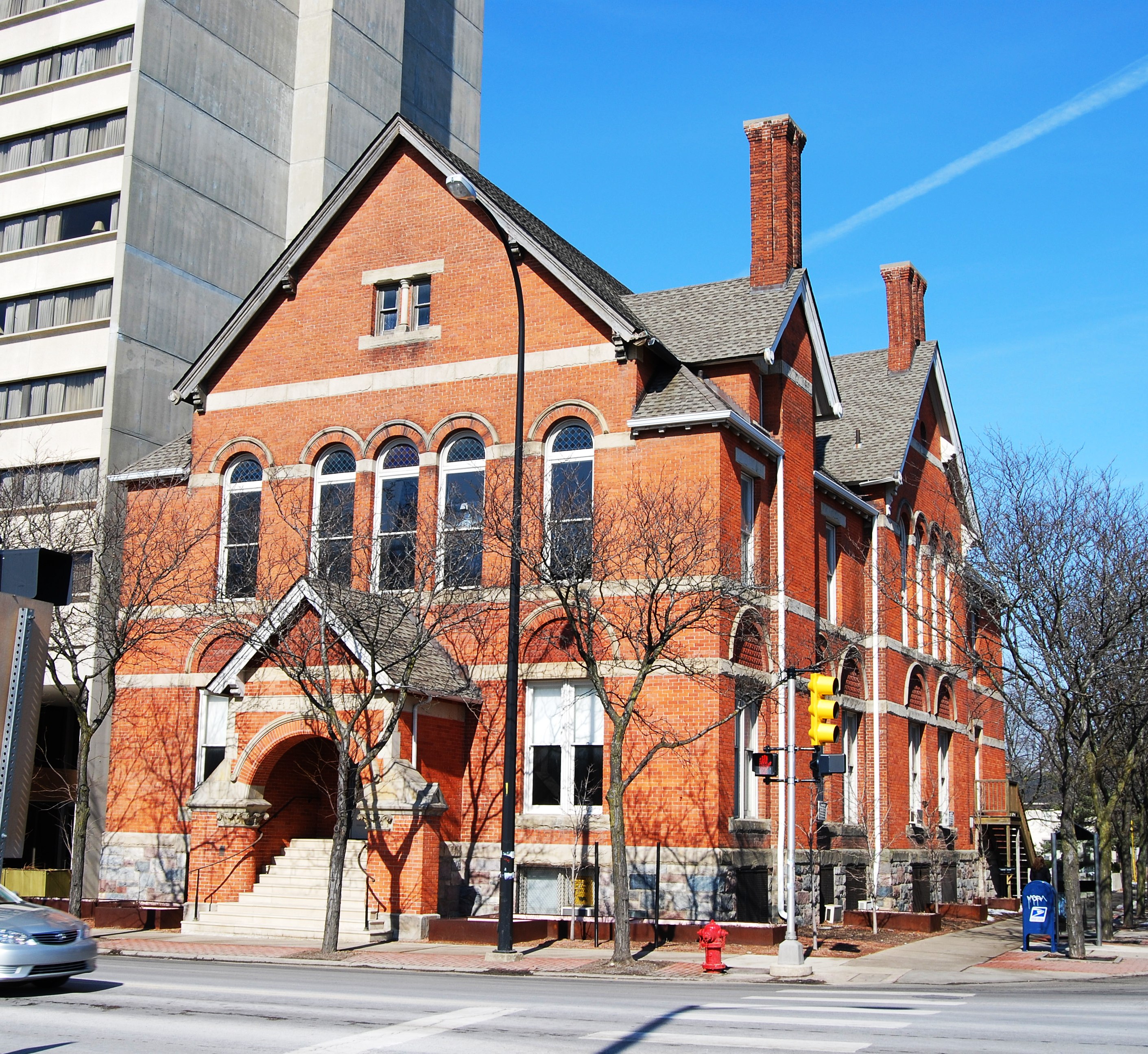
42°17′06″N 83°44′53″W / 42.285°N 83.748056°WAnn Arbor 33 Ladies' Literary Club Building 
March 16, 1972 218 N. Washington St.
42°14′40″N 83°36′51″W / 42.244444°N 83.614167°WYpsilanti Also known as Arden H. Ballard House 34 James Litchfield House 
December 27, 1984 3512 Central St.
42°20′20″N 83°52′55″W / 42.338889°N 83.881944°WDexter 35 George R. Lutz House 
October 10, 1985 103 W. Henry St.
42°09′54″N 83°46′53″W / 42.165°N 83.781389°WSaline 36 Main Street Historic District 
April 14, 1999 3-153 E. Main, 1-41 W. Main, and 8 Park Lane
42°05′05″N 83°41′01″W / 42.084722°N 83.683611°WMilan 37 Main Street Post Office 
May 22, 1978 220 N. Main St.
42°16′58″N 83°44′53″W / 42.282778°N 83.748056°WAnn Arbor 38 Floyd R. Mechem House 
December 9, 1999 1402 Hill St.
42°16′19″N 83°43′53″W / 42.271944°N 83.731389°WAnn Arbor 39 Methodist Episcopal Church Parsonage 
March 18, 1982 322 E. Washington St.
42°16′48″N 83°44′41″W / 42.28°N 83.744722°WAnn Arbor 40 Michigan Central Railroad Chelsea Depot 
June 12, 1987 150 Jackson St.
42°19′09″N 84°01′11″W / 42.319167°N 84.019722°WChelsea 41 Michigan Central Railroad Depot 
March 10, 1975 401 Depot St.
42°17′14″N 83°44′32″W / 42.287222°N 83.742222°WAnn Arbor Now occupied by the Gandy Dancer restauarant 42 Michigan Theater Building 
November 28, 1980 521-109 E. Liberty St.
42°16′46″N 83°44′31″W / 42.279444°N 83.741944°WAnn Arbor 43 Miller-Walker House 
October 10, 1985 117 McKay St.
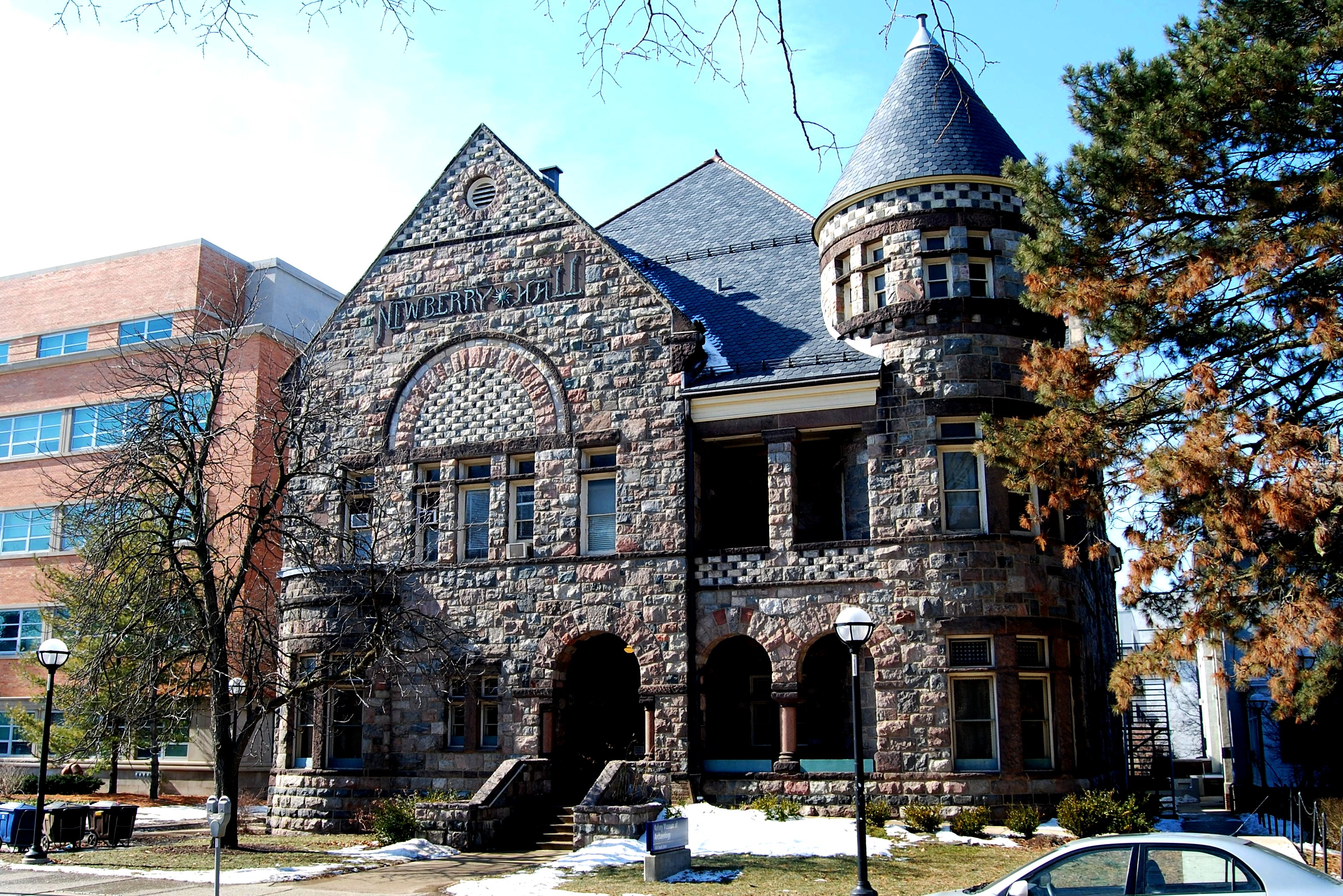
42°10′00″N 83°47′01″W / 42.166667°N 83.783611°WSaline 44 Newberry Hall 
March 24, 1972 434 S. State St.
42°16′36″N 83°44′28″W / 42.276667°N 83.741111°WAnn Arbor 45 Nickels Arcade 
July 9, 1987 326-330 S. State St.
42°16′42″N 83°44′29″W / 42.278333°N 83.741389°WAnn Arbor 46 North Ann Arbor Street Historic District 
October 10, 1985 301, 303, and 305-327 N. Ann Arbor St.
42°10′12″N 83°47′01″W / 42.17°N 83.783611°WSaline 47 Northern Brewery 
November 20, 1979 1327 Jones Dr.
42°17′33″N 83°44′05″W / 42.2925°N 83.734722°WAnn Arbor 48 Oakwood Cemetery Mausoleum 
October 10, 1985 Off Monroe St.
42°09′49″N 83°47′06″W / 42.163611°N 83.785°WSaline 49 Old West Side Historic District 
April 14, 1972 Bounded roughly by 7th, Main, and Huron Sts., Pauline Blvd., and Crest Ave.
42°16′26″N 83°45′23″W / 42.273889°N 83.756389°WAnn Arbor 50 George W. Palmer House 
November 29, 1996 138 E. Middle St.
42°19′05″N 84°01′08″W / 42.318056°N 84.018889°WChelsea 51 William B. and Mary Shuford Palmer House 
March 29, 1999 227 Orchard Hills Dr.
42°16′43″N 83°42′57″W / 42.278611°N 83.715833°WAnn Arbor 52 Parker Mill Complex 
August 4, 1982 East of Ann Arbor at Geddes and Dixboro Rds.
42°16′26″N 83°40′07″W / 42.273889°N 83.668611°WAnn Arbor 53 Pease Auditorium 
October 4, 1984 College Pl.
42°14′47″N 83°37′18″W / 42.246389°N 83.621667°WYpsilanti 54 President's House, University Of Michigan 
October 15, 1970 815 S. University, University of Michigan campus
42°16′31″N 83°44′19″W / 42.275278°N 83.738611°WAnn Arbor 55 Saint Mary's School 
December 13, 2010 400 Congdon St.
42°18′54″N 84°01′21″W / 42.315°N 84.0225°WChelsea 56 St. Patrick's Parish Complex 
April 23, 1982 Northfield Church and Whitmore Lake Rds.
42°21′29″N 83°45′01″W / 42.358056°N 83.750278°WAnn Arbor 57 Salem Methodist Episcopal Church and Salem Walker Cemetery 
August 18, 1992 7150 Angle Rd., Salem Township
42°24′38″N 83°37′25″W / 42.410556°N 83.623611°WSalem 58 Saline First Presbyterian Church 
October 10, 1985 143 E. Michigan Ave.
42°10′02″N 83°46′50″W / 42.167222°N 83.780556°WSaline 59 Schuyler Mill – Ford Soybean Plant Complex 
May 8, 1996 555-600 Michigan Ave.
42°09′45″N 83°47′24″W / 42.1625°N 83.79°WSaline 60 Starkweather Religious Center 
April 13, 1977 901 W. Forest
42°14′47″N 83°37′27″W / 42.246389°N 83.624167°WYpsilanti 61 Stone School 
November 29, 1995 2600 Packard Rd.
42°14′49″N 83°43′10″W / 42.246944°N 83.719444°WAnn Arbor 62 Louis Sturm House 
October 10, 1985 100 Russell
42°10′06″N 83°47′03″W / 42.168333°N 83.784167°WSaline 63 Landgford and Lydia McMichael Sutherland Farmstead 
May 16, 2006 797 Textile Rd.
42°11′57″N 83°44′26″W / 42.199167°N 83.740556°WPittsfield Charter Township 64 Dr. Benajah Ticknor House 
November 21, 1972 2781 Packard Rd.
42°14′42″N 83°42′38″W / 42.245°N 83.710556°WAnn Arbor 65 Tuomy Hills Service Station 
March 24, 2000 2460 Washtenaw Ave.
42°15′34″N 83°42′44″W / 42.259444°N 83.712222°WAnn Arbor 66 Union Block 
October 10, 1985 100-110 E. Michigan Ave.
42°09′59″N 83°46′51″W / 42.166389°N 83.780833°WSaline 67 Unitarian Universalist Church 
October 4, 1978 100 N. State St.
42°16′53″N 83°44′26″W / 42.281389°N 83.740556°WAnn Arbor 68 University Of Michigan Central Campus Historic District 
June 15, 1978 University of Michigan campus
42°16′37″N 83°44′15″W / 42.276944°N 83.7375°WAnn Arbor 69 Samuel D. Van Duzer House 
October 10, 1985 205 S. Ann Arbor St.
42°09′54″N 83°46′48″W / 42.165°N 83.78°WSaline 70 Wallace Block-Old Saline Village Hall 
October 10, 1985 101-113 S. Ann Arbor St.
42°09′58″N 83°46′51″W / 42.166111°N 83.780833°WSaline 71 Henry R. Watson House 
October 10, 1985 7215 N. Ann Arbor-Saline Rd.
42°10′50″N 83°47′13″W / 42.180556°N 83.786944°WSaline 72 Weinmann Block 
September 8, 1983 219-223 E. Washington St.
42°16′50″N 83°44′47″W / 42.280556°N 83.746389°WAnn Arbor 73 Orrin White House 
April 16, 1971 2940 Fuller Rd.
42°16′41″N 83°42′07″W / 42.278056°N 83.701944°WAnn Arbor 74 Judge Robert S. Wilson House 
March 16, 1972 126 N. Division St.
42°16′55″N 83°44′37″W / 42.281944°N 83.743611°WAnn Arbor 75 Ypsilanti Historic District 
April 11, 1978 Irregular pattern along Huron River with boundaries extending to Forest Ave., Grove, Buffalo, and Hamilton Sts.
42°14′36″N 83°36′41″W / 42.243333°N 83.611389°WYpsilanti Boundary increase (added 1989-01-05): Roughly Michigan, Summit, W. Cross, W. Forest, and Ballard; S. Adams and Woodward; Forest, Grove, Cross, and River 76 Ypsilanti Water Works Stand Pipe 
October 26, 1981 Summit and Cross Sts.
42°14′44″N 83°37′29″W / 42.245556°N 83.624722°WYpsilanti Former listing
[2] Landmark name Image Date listed Location City or town Summary 1 South Lima Rural Historic District Jerusalem, Liberty, Scio Church, Fletcher, Lima Center, Dancer, and Steinback Rds. Lima See also
- List of Registered Historic Places in Michigan
References
- ^ "National Register of Historic Places: Weekly List Actions". National Park Service, United States Department of the Interior. Retrieved on November 10, 2011.
- ^ a b Numbers represent an ordering by significant words. Various colorings, defined here, differentiate National Historic Landmark sites and National Register of Historic Places Districts from other NRHP buildings, structures, sites or objects.
- ^ "National Register Information System". National Register of Historic Places. National Park Service. . http://nrhp.focus.nps.gov/natreg/docs/All_Data.html.
U.S. National Register of Historic Places Topics Lists by states Alabama • Alaska • Arizona • Arkansas • California • Colorado • Connecticut • Delaware • Florida • Georgia • Hawaii • Idaho • Illinois • Indiana • Iowa • Kansas • Kentucky • Louisiana • Maine • Maryland • Massachusetts • Michigan • Minnesota • Mississippi • Missouri • Montana • Nebraska • Nevada • New Hampshire • New Jersey • New Mexico • New York • North Carolina • North Dakota • Ohio • Oklahoma • Oregon • Pennsylvania • Rhode Island • South Carolina • South Dakota • Tennessee • Texas • Utah • Vermont • Virginia • Washington • West Virginia • Wisconsin • WyomingLists by territories Lists by associated states Other Categories:- National Register of Historic Places in Michigan by county
- Washtenaw County, Michigan
-


Wikimedia Foundation. 2010.