- National Register of Historic Places listings in Webster County, Iowa
-
 Location of Webster County in Iowa
This is a list of the National Register of Historic Places listings in Webster County, Iowa.
This is intended to be a complete list of the properties and districts on the National Register of Historic Places in Webster County, Iowa, United States. Latitude and longitude coordinates are provided for many National Register properties and districts; these locations may be seen together in a Google map.[1]
There are 12 properties and districts listed on the National Register in the county.
-
- This National Park Service list is complete through NPS recent listings posted November 10, 2011.[2]
[3] Landmark name [4] Image Date listed Location City or town Summary 1 Lorenzo S. Coffin Burial Plot November 17, 1977 Northwest of Fort Dodge on Iowa Highway 7
42°31′40″N 94°14′26″W / 42.527778°N 94.240556°WFort Dodge 2 Corpus Christi Church October 8, 1976 416 N. 8th St.
42°30′31″N 94°11′20″W / 42.508611°N 94.188889°WFort Dodge 3 Dolliver Memorial State Park, Entrance Area (Area A) November 15, 1990 North of Iowa Highway 50 on the Des Moines River
42°24′06″N 94°04′56″W / 42.401667°N 94.082222°WLehigh 4 Dolliver Memorial State Park, Picnic, Hiking & Maintenance Area (Area B) November 15, 1990 North of Iowa Highway 50 on the Des Moines River
42°23′13″N 94°04′53″W / 42.386944°N 94.081389°WLehigh 5 First National Bank Building February 27, 2003 629 Central Ave.
42°30′17″N 94°11′19″W / 42.504722°N 94.188611°WFort Dodge 6 Fort Dodge Downtown Historic District November 10, 2010 1st Ave. N., Central Ave., and 1st Ave. S. from 3rd St. on the west to 12th St. on east
42°30′18″N 94°11′15″W / 42.505°N 94.1875°WFort Dodge 7 Oak Hill Historic District May 5, 1977 8th-12th Sts. and 2nd and 3rd Aves.
42°30′20″N 94°11′11″W / 42.505556°N 94.186389°WFort Dodge 8 Oakland Cemetery August 25, 2000 1600 N. 15th St.
42°30′45″N 94°10′47″W / 42.5125°N 94.179722°WFort Dodge 9 Oleson Park Music Pavilion 
May 9, 2003 1400 Oleson Park Ave.
42°29′20″N 94°10′20″W / 42.488889°N 94.172222°WFort Dodge 10 Vincent House 
April 23, 1973 824 3rd Ave., S.
42°30′10″N 94°11′01″W / 42.502778°N 94.183611°WFort Dodge 11 Wahkonsa Hotel 
May 21, 2008 927 Central Ave.
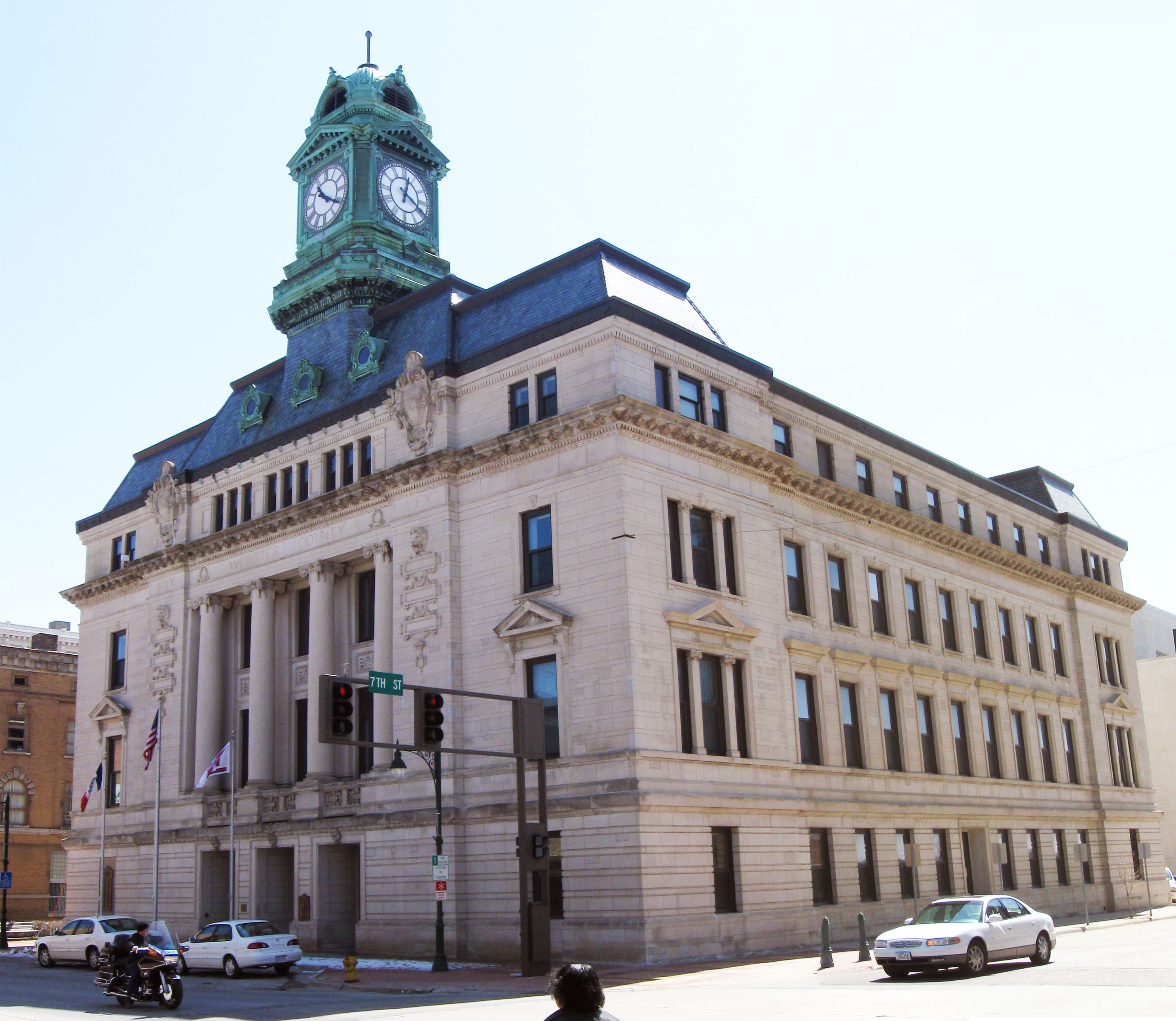
42°30′19″N 94°11′09″W / 42.50534°N 94.18574°WFort Dodge 12 Webster County Courthouse 
July 2, 1981 701 Central Ave.
42°30′17″N 94°11′17″W / 42.504722°N 94.188056°WFort Dodge See also
References
- ^ The latitude and longitude information provided in this table was derived originally from the National Register Information System, which has been found to be fairly accurate for about 99% of listings. For about 1% of NRIS original coordinates, experience has shown that one or both coordinates are typos or otherwise extremely far off; some corrections may have been made. A more subtle problem causes many locations to be off by up to 150 yards, depending on location in the country: most NRIS coordinates were derived from tracing out latitude and longitudes off of USGS topographical quadrant maps created under North American Datum of 1927, which differs from the current, highly accurate GPS system used by Google maps. Chicago is about right, but NRIS longitudes in Washington are higher by about 4.5 seconds, and are lower by about 2.0 seconds in Maine. Latitudes differ by about 1.0 second in Florida. Some locations in this table may have been corrected to current GPS standards.
- ^ "National Register of Historic Places: Weekly List Actions". National Park Service, United States Department of the Interior. Retrieved on November 10, 2011.
- ^ Numbers represent an ordering by significant words. Various colorings, defined here, differentiate National Historic Landmark sites and National Register of Historic Places Districts from other NRHP buildings, structures, sites or objects.
- ^ "National Register Information System". National Register of Historic Places. National Park Service. . http://nrhp.focus.nps.gov/natreg/docs/All_Data.html.
U.S. National Register of Historic Places Topics Lists by states Alabama • Alaska • Arizona • Arkansas • California • Colorado • Connecticut • Delaware • Florida • Georgia • Hawaii • Idaho • Illinois • Indiana • Iowa • Kansas • Kentucky • Louisiana • Maine • Maryland • Massachusetts • Michigan • Minnesota • Mississippi • Missouri • Montana • Nebraska • Nevada • New Hampshire • New Jersey • New Mexico • New York • North Carolina • North Dakota • Ohio • Oklahoma • Oregon • Pennsylvania • Rhode Island • South Carolina • South Dakota • Tennessee • Texas • Utah • Vermont • Virginia • Washington • West Virginia • Wisconsin • WyomingLists by territories Lists by associated states Other  Category:National Register of Historic Places •
  Portal:National Register of Historic Places
Municipalities and communities of Webster County, Iowa County seat: Fort Dodge Cities 
Townships Badger | Burnside | Clay | Colfax | Cooper | Dayton | Deer Creek | Douglas | Elkhorn | Fulton | Gowrie | Hardin | Jackson | Johnson | Lost Grove | Newark | Otho | Pleasant Valley | Roland | Sumner | Washington | Webster | Yell
CDP Communities Burnside | Lanyon | Lena | Lundgren | Palm Grove | Roelyn | Slifer
Footnotes ‡This populated place also has portions in an adjacent county or counties
Categories:- National Register of Historic Places in Iowa by county
- Webster County, Iowa
- Buildings and structures in Webster County, Iowa
-


Wikimedia Foundation. 2010.