- National Register of Historic Places listings in Westmoreland County, Pennsylvania
-
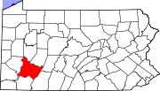
 Location of Westmoreland County
This is a list of the National Register of Historic Places listings in Westmoreland County, Pennsylvania.
This is intended to be a complete list of the properties and districts on the National Register of Historic Places in Westmoreland County, Pennsylvania, United States. The locations of National Register properties and districts for which the latitude and longitude coordinates are included below, may be seen in a Google map.[1]
There are 52 properties and districts listed on the National Register in the county. One site is further designated as a National Historic Landmark. Another property was once listed but has been removed.
-
- This National Park Service list is complete through NPS recent listings posted November 10, 2011.[2]
Current listings
[3] Landmark name[4] Image Date listed Location City or Town Summary 1 Academy Hill Historic District 
April 29, 1999 Roughly bounded by Baughman Street, North Maple Avenue, Kenneth Street, Culbertson Avenue, Beacon Street, and Pennsylvania Avenue
40°18′39″N 79°32′42″W / 40.31083°N 79.545°WGreensburg 2 Allegheny River Lock and Dam No. 4 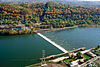
April 21, 2000 1 River Avenue
40°36′52″N 79°42′59″W / 40.61444°N 79.71639°WLower Burrell Extends into Harrison Township in Allegheny County 3 Bells Mills Covered Bridge 
June 27, 1980 West of Yukon
40°13′9″N 79°42′37″W / 40.21917°N 79.71028°WSewickley and South Huntingdon Townships 4 Brush Creek Salems Church May 11, 1987 Southeast of Westmoreland City on Brush Creek Road
40°19′9″N 79°39′30″W / 40.31917°N 79.65833°WHempfield Township 5 Brush Hill October 14, 1975 651 Brush Hill Road
40°19′30″N 79°41′22″W / 40.325°N 79.68944°WIrwin 6 Bushy Run Battlefield 
October 15, 1966 2 miles (3.2 km) east of Harrison City on Pennsylvania Route 993
40°21′21″N 79°37′30″W / 40.35583°N 79.625°WPenn Township 7 Byerly House July 18, 1985 115 Menk Road, east of New Kensington
40°33′14″N 79°41′1″W / 40.55389°N 79.68361°WUpper Burrell Township 8 Charleroi-Monessen Bridge 
June 22, 1988 Legislative Route 247 over the Monongahela River
40°9′6″N 79°54′15″W / 40.15167°N 79.90417°WMonessen Extends into North Charleroi in Washington County 9 Citizens National Bank of Latrobe 
November 1, 2002 816 Ligonier Street
40°19′0″N 79°23′5″W / 40.316667°N 79.38472°WLatrobe 10 Compass Inn 
February 24, 1995 Junction of U.S. Route 30 (the Lincoln Highway) and California Avenue
40°12′43″N 79°11′57″W / 40.21194°N 79.19917°WLigonier Township 11 Dick Building 
August 30, 2007 201–203 East Main Street
40°12′6″N 79°46′0″W / 40.20167°N 79.766667°WWest Newton 12 Fairview Park December 27, 2010 South side of Old Route 22, approximately 1.5 miles (2.4 km) east of Delmont
40°24′21″N 79°33′21.5″W / 40.40583°N 79.555972°WSalem Township 13 Adam Fisher Homestead 
February 28, 1991 Brinkerton Road near junction with Mount Pleasant Road, northwest of Calumet
40°13′9″N 79°30′10″W / 40.21917°N 79.50278°WMount Pleasant Township 14 Fort Ligonier Site 
January 21, 1975 South Market Street
40°14′27″N 79°14′16″W / 40.24083°N 79.23778°WLigonier 15 Fullerton Inn June 30, 1983 11029 Old Trail Road, west of Irwin
40°19′47″N 79°43′35″W / 40.32972°N 79.72639°WNorth Huntingdon Township 16 Downtown Greensburg Historic District 
July 21, 1995 Roughly bounded by Tunnel Street, Main Street, Third Street and Harrison Avenue
40°18′11″N 79°32′42″W / 40.30306°N 79.545°WGreensburg 17 Greensburg Railroad Station 
November 7, 1977 Harrison Avenue
40°18′16″N 79°32′49″W / 40.30444°N 79.54694°WGreensburg 18 Hannastown Farm March 17, 1994 Northwest of the junction of Township 825 and Legislative Route 64054
40°21′11″N 79°30′21″W / 40.35306°N 79.50583°WSalem Township 19 Household No. 1 Site (36WM61) 
March 20, 1986 Off Timms Lane
40°10′27.7″N 79°46′44.4″W / 40.174361°N 79.779°W[5]Rostraver Township 20 Kingston House 
June 30, 1983 U.S. Route 30, northeast of Youngstown
40°17′28″N 79°20′29″W / 40.29111°N 79.34139°WUnity Township 21 Latrobe Armory 
December 22, 1989 1017 Ridge Avenue
40°19′0″N 79°22′53″W / 40.316667°N 79.38139°WLatrobe 22 Laurel Hill Furnace 
April 28, 1975 Southeast of New Florence on Baldwin Run
40°22′0″N 79°3′32″W / 40.366667°N 79.05889°WSt. Clair Township 23 Ligonier Armory May 9, 1991 358 West Main Street
40°14′49″N 79°14′33″W / 40.24694°N 79.2425°WLigonier Demolished.[6] 24 Ligonier Historic District 
August 30, 1994 Junction of Main and Market Streets
40°14′35″N 79°14′16″W / 40.24306°N 79.23778°WLigonier 25 Linn Run State Park Family Cabin District February 12, 1987 2 miles (3.2 km) southeast of Rector on Linn Run Road
40°9′14″N 79°13′0″W / 40.15389°N 79.216667°WCook Township 26 Andrew and Jennie McFarlane House August 4, 2004 50 Maus Drive, west of Irwin
40°19′47″N 79°44′21″W / 40.32972°N 79.73917°WNorth Huntingdon Township 27 Mount Pleasant Armory December 22, 1989 Eagle and Spring Streets
40°8′59″N 79°32′54″W / 40.14972°N 79.54833°WMount Pleasant Demolished in 1996[7] 28 Mount Pleasant Historic District 
July 23, 1998 Roughly along Main, South Church, Eagle, Walnut and College Streets
40°8′54″N 79°32′41″W / 40.14833°N 79.54472°WMount Pleasant 29 Mount St. Peter Roman Catholic Church 
May 5, 1998 100 Freeport Road
40°33′50″N 79°45′42″W / 40.56389°N 79.76167°WNew Kensington 30 New Kensington Downtown Historic District 
July 23, 1998 Roughly bounded by 8th Avenue, 3rd Street, 11th Avenue, and Barnes Avenue
40°33′58″N 79°45′58″W / 40.56611°N 79.76611°WNew Kensington 31 New Kensington Production Works Historic District May 7, 1998 Roughly along the Allegheny River, from Sixteenth Street to Seventh Street
40°33′56″N 79°46′13″W / 40.56556°N 79.77028°WNew Kensington 32 Samuel Patterson House March 7, 1985 Pennsylvania Route 981, north of New Alexandria
40°23′58″N 79°25′20″W / 40.39944°N 79.42222°WDerry Township 33 Pennsylvania Railroad Station-Latrobe 
July 17, 1986 Depot Street
40°19′7″N 79°23′8″W / 40.31861°N 79.38556°WLatrobe 34 Plumer House 
December 6, 1979 Vine and South Water Street
40°12′33″N 79°46′10″W / 40.20917°N 79.76944°WWest Newton 35 Ross Furnace September 6, 1991 Southwest of Tubmill Reservoir off Pennsylvania Route 711
40°19′33″N 79°5′26″W / 40.32583°N 79.09056°WFairfield Township 36 St. Gertrude Roman Catholic Church September 23, 1983 311 Franklin Avenue
40°36′10″N 79°34′7″W / 40.60278°N 79.56861°WVandergrift 37 St. Vincent Archabbey Gristmill January 18, 1978 Southwest of Latrobe off U.S. Route 30
40°17′43″N 79°24′10″W / 40.29528°N 79.40278°WUnity Township 38 Salem Crossroads Historic District 
September 18, 1978 Pittsburgh and Greensburg Streets
40°24′44″N 79°34′10″W / 40.41222°N 79.56944°WDelmont 39 Scottdale Armory 
May 9, 1991 501 North Broadway Street
40°6′17″N 79°35′8″W / 40.10472°N 79.58556°WScottdale 40 Scottdale Historic District 
March 29, 1996 Roughly bounded by Walnut Street, Constitution Way, Arthur Avenue and Jacob's Creek
40°6′5″N 79°35′22″W / 40.10139°N 79.58944°WScottdale 41 Sewickley Manor 
April 19, 1982 Legislative Route 64136, north of Calumet
40°14′5″N 79°28′56″W / 40.23472°N 79.48222°WMount Pleasant Township 42 Site of Old Hannastown January 26, 1972 4 miles (6.4 km) northeast of Greensburg
40°20′37″N 79°30′19″W / 40.34361°N 79.50528°WHempfield Township 43 Slickville Historic District 
June 3, 1994 Roughly bounded by Greenburg and Second Avenue and Delmont, Court, Cottage and Fred Streets, in Slickville
40°27′27″N 79°31′23″W / 40.4575°N 79.52306°WSalem Township 44 Squirrel Hill Site March 26, 1980 West of New Florence near the banks of the Conemaugh River
40°22′49.05″N 79°5′20.28″W / 40.3802917°N 79.0889667°W[8]St. Clair Township 45 Vandergrift Historic District 
April 27, 1995 Roughly bounded by Lincoln, Sherman, Franklin and Washington Avenues, along the outer lot lines
40°36′9″N 79°33′44″W / 40.6025°N 79.56222°WVandergrift 46 John Walter Farmstead July 21, 1995 166 Mamont Drive
40°32′52″N 79°35′21″W / 40.54778°N 79.58917°WWashington Township 47 Samuel Warden House 
November 7, 1995 200 South Church Street
40°8′52″N 79°32′50″W / 40.14778°N 79.54722°WMount Pleasant 48 Webster Donora Bridge 
June 22, 1988 Pennsylvania Route 143 over the Monongahela River at Webster
40°11′3″N 79°51′8″W / 40.18417°N 79.85222°WRostraver Township Extends into Washington County 49 West Overton Historic District 
July 18, 1985 Frick Avenue
40°6′59″N 79°33′59″W / 40.11639°N 79.56639°WEast Huntingdon Township 50 Western Division of the PA Canal November 14, 1982 Along the Conemaugh River
40°25′31″N 79°13′48″W / 40.42528°N 79.23°WBolivar, Derry Township, and Fairfield Township 51 Western Division-Pennsylvania Canal September 17, 1974 Along the Conemaugh River
40°25′30″N 79°13′48″W / 40.425°N 79.23°WBell, Derry, and Loyalhanna Townships 52 Westmoreland County Courthouse 
March 30, 1978 North Main Street
40°18′9″N 79°32′46″W / 40.3025°N 79.54611°WGreensburg Former listing
[3] Landmark name[4] Image Date delisted Location City or Town Summary 1 Gen. Greene Hotel 
June 16, 1988 24 West Otterman Street Greensburg Built 1903
demolishedSee also
- List of National Historic Landmarks in Pennsylvania
- National Register of Historic Places listings in Pennsylvania
- List of Pennsylvania state historical markers in Westmoreland County
References
- ^ The latitude and longitude information provided in this table was derived originally from the National Register Information System, which has been found to be fairly accurate for about 99% of listings. For about 1% of NRIS original coordinates, experience has shown that one or both coordinates are typos or otherwise extremely far off; some corrections may have been made. A more subtle problem causes many locations to be off by up to 150 yards, depending on location in the country: most NRIS coordinates were derived from tracing out latitude and longitudes off of USGS topographical quadrant maps created under North American Datum of 1927, which differs from the current, highly accurate GPS system used by Google maps. Chicago is about right, but NRIS longitudes in Washington are higher by about 4.5 seconds, and are lower by about 2.0 seconds in Maine. Latitudes differ by about 1.0 second in Florida. Some locations in this table may have been corrected to current GPS standards.
- ^ "National Register of Historic Places: Weekly List Actions". National Park Service, United States Department of the Interior. Retrieved on November 10, 2011.
- ^ a b Numbers represent an ordering by significant words. Various colorings, defined here, differentiate National Historic Landmark sites and National Register of Historic Places Districts from other NRHP buildings, structures, sites or objects.
- ^ a b "NPS Focus". National Register of Historic Places. National Park Service. http://nrhp.focus.nps.gov. Retrieved November 20, 2009.
- ^ Location derived from its NRHP nomination form; the NRIS lists the site as "Address Restricted"
- ^ Phraner, Jewel (January 12, 2010). "Housing complex on armory site gets planners' OK". Pittsburgh Tribune-Review. http://pittsburghlive.com/x/pittsburghtrib/news/westmoreland/s_717785.html. Retrieved March 14, 2011.
- ^ "Pennsylvania National Guard Military Museum: Mount Pleasant Armory". PNG Military Museum. http://www.pngmilitarymuseum.org/history/pa_armories/mount_pleasant.html. Retrieved 2011-08-24.
- ^ Location derived from its NRHP nomination form; the NRIS lists the site as "Address Restricted"
Municipalities and communities of Westmoreland County, Pennsylvania County seat: Greensburg Cities Arnold | Greensburg | Jeannette | Latrobe | Lower Burrell | Monessen | New Kensington
Boroughs Adamsburg | Arona | Avonmore | Bolivar | Delmont | Derry | Donegal | East Vandergrift | Export | Hunker | Hyde Park | Irwin | Laurel Mountain | Ligonier | Madison | Manor | Mount Pleasant | Murrysville | New Alexandria | New Florence | New Stanton | North Belle Vernon | North Irwin | Oklahoma | Penn | Scottdale | Seward | Smithton | South Greensburg | Southwest Greensburg | Sutersville | Trafford‡ | Vandergrift | West Leechburg | West Newton | Youngstown | Youngwood
Townships Allegheny | Bell | Cook | Derry | Donegal | East Huntingdon | Fairfield | Hempfield | Ligonier | Loyalhanna | Mount Pleasant | North Huntingdon | Penn | Rostraver | St. Clair | Salem | Sewickley | South Huntingdon | Unity | Upper Burrell | Washington
CDPs Unincorporated
communitiesAcme | Boquet | Calumet | Hannastown | Hopewell | Hutchinson | Kecksburg | Lloydsville | Luxor | Moween | Norvelt | Ruffs Dale | Southwest | Stahlstown | Standard Shaft | Salina | Turkeytown | United
Ghost town Footnotes ‡This populated place also has portions in an adjacent county or counties
Categories:- Westmoreland County, Pennsylvania
- National Register of Historic Places in Pennsylvania by county
-


Wikimedia Foundation. 2010.