- National Register of Historic Places listings in Windsor, Connecticut
-
 Location of Windsor in Connecticut
This is a list of the National Register of Historic Places listings in Windsor, Connecticut.
This is intended to be a complete list of the properties and districts on the National Register of Historic Places in Windsor, Connecticut, United States. The locations of National Register properties and districts for which the latitude and longitude coordinates are included below, may be seen in various online maps.[1]
There are 411 properties and districts listed on the National Register in Hartford County, including 20 National Historic Landmarks. The 41 properties and districts located in the town of Windsor include one National Historic Landmark and are listed below. The 370 properties and districts in the remaining parts of the county are listed separately.
Contents: Counties in Connecticut Fairfield (city of Bridgeport) (town of Greenwich) (city of Stamford) | Hartford (city of Hartford) (town of Southington) (town of West Hartford) (town of Windsor) | Litchfield | Middlesex (city of Middletown) | New Haven (city of New Haven) | New London | Tolland | Windham
-
- This National Park Service list is complete through NPS recent listings posted November 10, 2011.[2]
Current listings
[3] Landmark name[4] Image Date listed Location Summary 1 Capt. Benjamin Allyn II House June 26, 1979 119 Deerfield Rd.
41°49′17″N 72°39′13″W / 41.82139°N 72.65361°W2 Giles Barber House September 15, 1988 411-413 Windsor Ave.
41°48′53″N 72°39′29″W / 41.81472°N 72.65806°W3 Bissell Tavern-Bissell's Stage House August 23, 1985 1022 Palisado Ave.
41°53′12″N 72°38′2″W / 41.88667°N 72.63389°W4 Broad Street Green Historic District December 30, 1999 Roughly along Broad St. from Batchelder Rd. to Union St.
41°51′1″N 72°38′33″W / 41.85028°N 72.6425°W5 Benomi Case House September 15, 1988 436 Rainbow Rd.
41°55′5″N 72°41′35″W / 41.91806°N 72.69306°W6 Hezekiah Chaffee House 
July 31, 1972 Meadow Lane off Palisado Green
41°51′28″N 72°38′11″W / 41.85778°N 72.63639°W7 Taylor Chapman House September 15, 1988 407 Palisado Ave.
41°51′59″N 72°37′49″W / 41.86639°N 72.63028°W8 Horace H. Ellsworth House September 15, 1988 316 Palisado Ave.
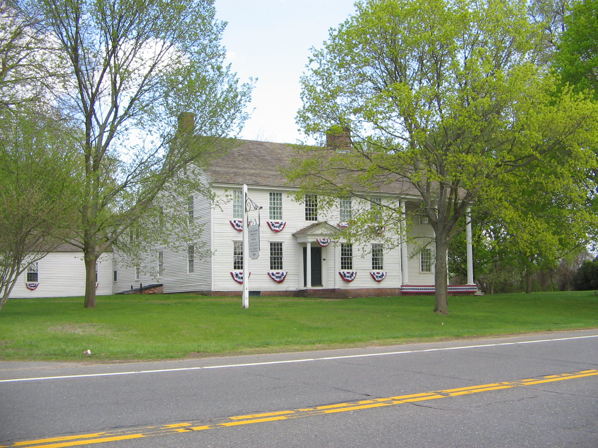
41°51′49″N 72°37′53″W / 41.86361°N 72.63139°W9 Oliver Ellsworth Homestead 
October 6, 1970 778 Palisado Ave.
41°52′40″N 72°37′31″W / 41.87778°N 72.62528°WHome of the third Chief Justice of the United States 10 Farmington River Railroad Bridge August 25, 1972 Spans the Farmington River and Pleasant St. west of Palisado Ave.
41°51′28″N 72°38′30″W / 41.85778°N 72.64167°W11 First Church Parsonage 
September 15, 1988 160 Palisado Ave.
41°52′4″N 72°38′8″W / 41.86778°N 72.63556°W12 John Fitch School December 2, 1986 156 Bloomfield Ave.
41°51′10″N 72°39′6″W / 41.85278°N 72.65167°W13 Former Fire Station 
September 15, 1988 14 Maple Ave.
41°51′5″N 72°38′44″W / 41.85139°N 72.64556°W14 Grace Church Rectory 
September 15, 1988 301 Broad St.
41°50′59″N 72°38′37″W / 41.84972°N 72.64361°W15 Hartford & New Haven Railroad Depot 
September 15, 1988 Central St.
41°51′8″N 72°38′34″W / 41.85222°N 72.64278°W16 Hartford & New Haven Railroad-Freight Depot 
September 15, 1988 40 Central St.
41°51′6″N 72°38′32″W / 41.85167°N 72.64222°W17 William H. Harvey House 
September 15, 1988 1173 Windsor Ave.
41°50′23″N 72°39′7″W / 41.83972°N 72.65194°W18 Hathaways Store September 15, 1988 32 East St.
41°51′25″N 72°38′57″W / 41.85694°N 72.64917°W19 Capt. Nathaniel Hayden House 
September 15, 1988 128 Hayden Station Rd.
41°53′31″N 72°37′49″W / 41.89194°N 72.63028°W20 House at 111 Maple Avenue September 15, 1988 111 Maple Ave.
41°51′4″N 72°38′59″W / 41.85111°N 72.64972°W21 House at 130 Hayden Station Road September 15, 1988 130 Hayden Station Rd.
41°53′32″N 72°37′55″W / 41.89222°N 72.63194°W22 House at 44 Court Street 
September 15, 1988 44 Court St.
41°51′7″N 72°38′48″W / 41.85194°N 72.64667°W23 House at 736 Palisado Avenue September 15, 1988 736 Palisado Ave.
41°52′37″N 72°37′32″W / 41.87694°N 72.62556°W24 Capt. James Loomis House 
September 15, 1988 881 Windsor Ave.
41°49′47″N 72°39′24″W / 41.82972°N 72.65667°W25 Col. James Loomis House September 15, 1988 208-210 Broad St.
41°51′7″N 72°38′41″W / 41.85194°N 72.64472°W26 George G. Loomis House September 15, 1988 1003 Windsor Ave.
41°50′3″N 72°39′18″W / 41.83417°N 72.655°W27 Gordon Loomis House September 15, 1988 1021 Windsor Ave.
41°50′5″N 72°39′18″W / 41.83472°N 72.655°W28 Ira Loomis, Jr. House September 15, 1988 1053 Windsor Ave.
41°50′8″N 72°39′17″W / 41.83556°N 72.65472°W29 Henry Magill House September 15, 1988 390 Palisado Ave.
41°51′57″N 72°37′48″W / 41.86583°N 72.63°W30 Elijah Mills House August 23, 1985 45 Deerfield Rd.
41°49′6″N 72°39′20″W / 41.81833°N 72.65556°W31 Oliver W. Mills House February 19, 1982 148 Deerfield Rd.
41°49′16″N 72°39′9″W / 41.82111°N 72.6525°W32 Timothy Dwight Mills House September 15, 1988 184 Deerfield Rd.
41°49′20″N 72°39′11″W / 41.82222°N 72.65306°W33 Deacon John Moore House July 29, 1977 37 Elm St.
41°51′5″N 72°38′45″W / 41.85139°N 72.64583°W34 Edward and Ann Moore House September 15, 1988 464 Broad St.
41°50′42″N 72°38′54″W / 41.845°N 72.64833°W35 Patrick Murphy House September 15, 1988 345 Palisado Ave.
41°51′53″N 72°37′53″W / 41.86472°N 72.63139°W36 Palisado Avenue Historic District August 25, 1987 Palisado Ave. (signed as Connecticut Route 159) between the Farmington River and Bissell Ferry Rd.
41°51′35″N 72°38′10″W / 41.85972°N 72.63611°W37 Daniel Payne House September 15, 1988 27 Park Ave.
41°50′20″N 72°39′14″W / 41.83889°N 72.65389°W38 Eli Phelps House September 15, 1988 18 Marshall Phelps Rd.
41°53′24″N 72°40′35″W / 41.89°N 72.67639°W39 William Shelton House September 15, 1988 40 Pleasant St.
41°51′29″N 72°38′58″W / 41.85806°N 72.64944°W40 Stony Hill School September 15, 1988 1195 Windsor Ave.
41°50′25″N 72°39′4″W / 41.84028°N 72.65111°W41 Sophia Sweetland House September 15, 1988 458 Palisado Ave.
41°52′4″N 72°37′45″W / 41.86778°N 72.62917°WSee also
- List of National Historic Landmarks in Connecticut
- National Register of Historic Places listings in Connecticut
References
- ^ The latitude and longitude information provided in this table was derived originally from the National Register Information System, which has been found to be fairly accurate for about 99% of listings. For about 1% of NRIS original coordinates, experience has shown that one or both coordinates are typos or otherwise extremely far off; some corrections may have been made. A more subtle problem causes many locations to be off by up to 150 yards, depending on location in the country: most NRIS coordinates were derived from tracing out latitude and longitudes off of USGS topographical quadrant maps created under the North American Datum of 1927, which differs from the current, highly accurate WGS84 GPS system used by Google maps. Chicago is about right, but NRIS longitudes in Washington are higher by about 4.5 seconds, and are lower by about 2.0 seconds in Maine. Latitudes differ by about 1.0 second in Florida. Some locations in this table may have been corrected to current GPS standards.
- ^ "National Register of Historic Places: Weekly List Actions". National Park Service, United States Department of the Interior. Retrieved on November 10, 2011.
- ^ Numbers represent an ordering by significant words. Various colorings, defined here, differentiate National Historic Landmark sites and National Register of Historic Places Districts from other NRHP buildings, structures, sites or objects.
- ^ "National Register Information System". National Register of Historic Places. National Park Service. 2009-03-13. http://nrhp.focus.nps.gov/natreg/docs/All_Data.html.
U.S. National Register of Historic Places Topics Lists by states Alabama • Alaska • Arizona • Arkansas • California • Colorado • Connecticut • Delaware • Florida • Georgia • Hawaii • Idaho • Illinois • Indiana • Iowa • Kansas • Kentucky • Louisiana • Maine • Maryland • Massachusetts • Michigan • Minnesota • Mississippi • Missouri • Montana • Nebraska • Nevada • New Hampshire • New Jersey • New Mexico • New York • North Carolina • North Dakota • Ohio • Oklahoma • Oregon • Pennsylvania • Rhode Island • South Carolina • South Dakota • Tennessee • Texas • Utah • Vermont • Virginia • Washington • West Virginia • Wisconsin • WyomingLists by territories Lists by associated states Other Categories:- National Register of Historic Places in Connecticut
- Windsor, Connecticut
-


Wikimedia Foundation. 2010.