- National Register of Historic Places listings in Yakima County, Washington
-
List of entries on the National Register of Historic Places in Yakima County, Washington
-
- This National Park Service list is complete through NPS recent listings posted November 10, 2011.[1]
[2] Landmark name Image Date listed Location City or town Summary 1 E. William Brackett House October 25, 1990 2606 Tieton Dr.
46°35′34″N 120°32′35″W / 46.592778°N 120.543056°WYakima 2 Brooker-Taylor House February 18, 1987 203 S. Naches Ave.
46°36′03″N 120°29′49″W / 46.600833°N 120.496944°WYakima 3 Buckeye Ranch House November 2, 1990 10881 WA 410
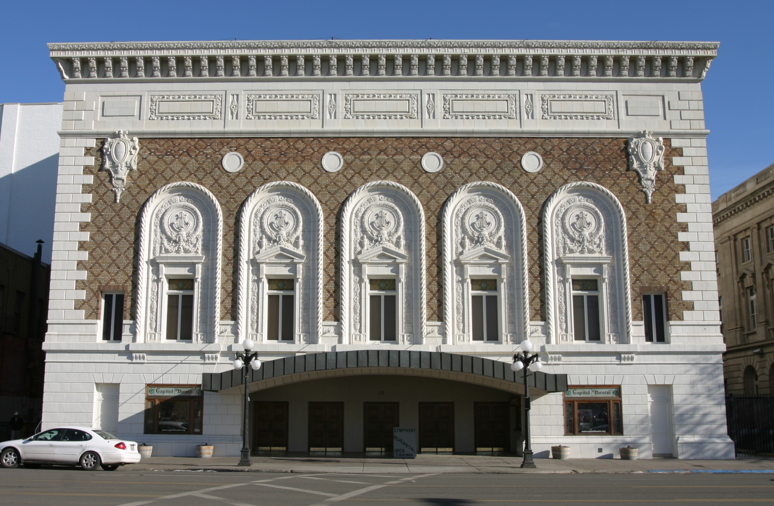
46°47′55″N 120°53′19″W / 46.798611°N 120.888611°WNaches 4 Capitol Theatre 
April 11, 1973 19 S. 3rd St.
46°36′09″N 120°30′04″W / 46.6025°N 120.501111°WYakima 5 Carbonneau Mansion 
December 12, 1976 620 S. 48th Ave.
46°35′29″N 120°34′22″W / 46.591389°N 120.572778°WYakima 6 Rupert Card House February 18, 1987 1105 W. A St.
46°35′59″N 120°31′27″W / 46.599722°N 120.524167°WYakima 7 Elizabeth Loudon Carmichael House May 1, 1991 108 W. Pine St.
46°33′06″N 120°28′34″W / 46.551667°N 120.476111°WUnion Gap 8 Carmichael-Loudon House February 18, 1987 2 Chicago Ave.
46°35′51″N 120°31′36″W / 46.5975°N 120.526667°WYakima 9 Cornell Farmstead February 17, 1987 Pleasant Rd. and Old Prosser Rd.
46°14′35″N 119°53′41″W / 46.243056°N 119.894722°WGrandview 10 Harrison Dills House February 18, 1987 4 N. Sixteenth Ave.
46°35′51″N 120°31′47″W / 46.5975°N 120.529722°WYakima 11 Donald House December 12, 1976 304 N. 2nd St.
46°36′24″N 120°30′21″W / 46.606667°N 120.505833°WYakima 12 Donald-Wapato Bridge May 24, 1995 Donald Rd. over the Yakima R.
46°27′58″N 120°23′51″W / 46.466111°N 120.3975°WWapato Bridges of Washington State MPS 13 Edgar Rock Lodge August 1, 1996 380 Old Naches Rd.
46°55′16″N 121°03′03″W / 46.921111°N 121.050833°WNaches 14 Fort Simcoe State Park 
June 27, 1974 SW of Yakima on WA 220
46°20′34″N 120°50′08″W / 46.342778°N 120.835556°WYakima 15 O. J. Gendron Ranch September 21, 2005 6702 Bell Rd.
46°33′34″N 120°24′57″W / 46.559444°N 120.415833°WMoxee City 16 H. M. Gilbert House August 23, 1985 2109 W. Yakima Ave.
46°35′51″N 120°32′11″W / 46.5975°N 120.536389°WYakima 17 James Gleed Barn May 10, 1990 1960 Old Naches Hwy.
46°39′42″N 120°36′13″W / 46.661667°N 120.603611°WNaches 18 Daniel Goodman House October 2, 1992 701 S. 3rd Ave.
46°35′28″N 120°30′28″W / 46.591111°N 120.507778°WYakima 19 Gothen Creek Ranger Station April 25, 2007 Forest Service Rd.
46°05′22″N 121°29′00″W / 46.089444°N 121.483333°WGifford Pinchot National Forest 20 Grandview Herald Building February 17, 1987 107 Division St.
46°15′21″N 119°54′01″W / 46.255833°N 119.900278°WGrandview 21 Grandview High School February 17, 1987 913 W. Second St.
46°15′19″N 119°54′42″W / 46.255278°N 119.911667°WGrandview 22 Grandview Road-Yellowstone Trail December 11, 1995 Grandview Pavement Rd. between Mabton-Sunnyside Rd. and Apple Way
46°15′01″N 119°59′50″W / 46.250278°N 119.997222°WGrandview 23 Grandview State Bank 
February 17, 1987 100 W. Second St.
46°15′17″N 119°54′04″W / 46.254722°N 119.901111°WGrandview 24 Grave of the Legendary Giantess December 14, 1978 Address Restricted Toppenish Not an actual grave, but a rock formation some think looks to have the outline of a woman. 25 James Greene House May 6, 1987 203 N. Ninth St.
46°36′32″N 120°29′37″W / 46.608889°N 120.493611°WYakima 26 A. E. Howard House February 18, 1987 602 N. First St.
46°36′36″N 120°30′32″W / 46.61°N 120.508889°WYakima 27 Howay-Dykstra House February 17, 1987 114 Birch St.
46°15′19″N 119°53′53″W / 46.255278°N 119.898056°WGrandview 28 William N. Irish House March 31, 1992 210 S. 28th Ave.
46°35′48″N 120°32′43″W / 46.596667°N 120.545278°WYakima 29 Kamiakin's Gardens December 22, 1976 W of Union Gap on Lower Ahtanum Rd.
46°31′46″N 120°49′32″W / 46.529444°N 120.825556°WUnion Gap 30 James Knuppenburg House February 18, 1987 111 S. Ninth St.
46°36′10″N 120°29′30″W / 46.602778°N 120.491667°WYakima 31 LaFramboise Farmstead February 28, 1985 5204 Mieras Rd.
46°34′37″N 120°25′44″W / 46.576944°N 120.428889°WYakima 32 A. E. Larson Building 
September 11, 1984 6 S. 2nd St.
46°36′08″N 120°30′13″W / 46.602222°N 120.503611°WYakima 33 Larson-Hellieson House May 6, 1987 208 N. Naches Ave.
46°36′25″N 120°30′03″W / 46.606944°N 120.500833°WYakima 34 William Lindsey House February 18, 1987 301 N. Eighth St.
46°36′32″N 120°29′44″W / 46.608889°N 120.495556°WYakima 35 Lund Building October 13, 1983 5 N. Front St.
46°36′08″N 120°30′23″W / 46.602222°N 120.506389°WYakima 36 Mabton High School November 21, 1985 High School Rd.
46°12′44″N 119°59′25″W / 46.212222°N 119.990278°WMabton 37 Masonic Temple 
February 16, 1996 321 E. Yakima Ave.
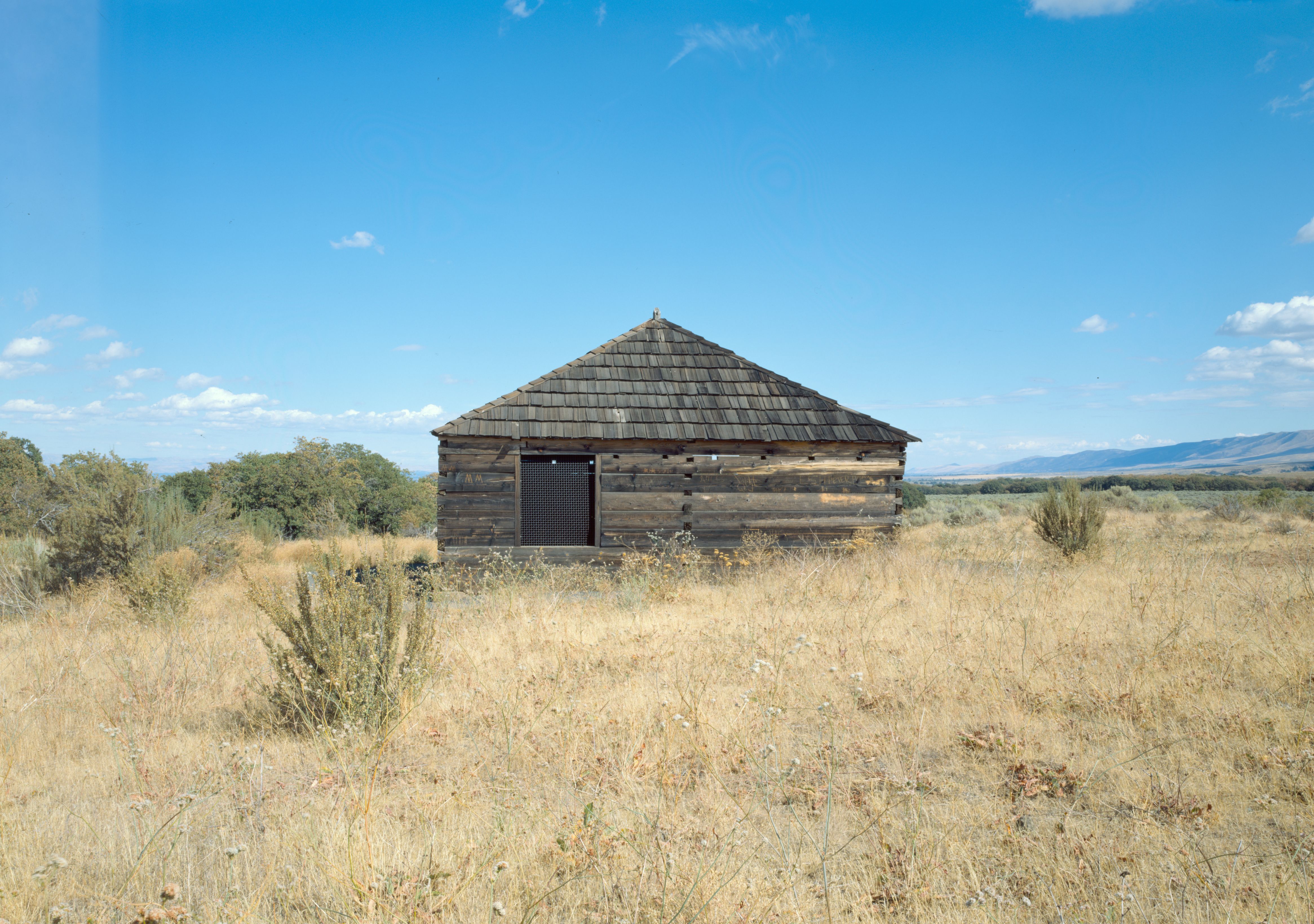
46°36′13″N 120°30′02″W / 46.603611°N 120.500556°WYakima Also known as the Great Western Building. 38 Mattoon Cabin October 28, 1977 S of Sawyer on U.S. 12
46°27′07″N 120°21′23″W / 46.451944°N 120.356389°WSawyer 39 Alexander McAllister House October 25, 1990 402 W. White St.
46°32′59″N 120°28′47″W / 46.549722°N 120.479722°WUnion Gap 40 John J. Miller House February 18, 1987 9 S. Tenth Ave.
46°35′52″N 120°31′16″W / 46.597778°N 120.521111°WYakima 41 Francis Mineau House February 18, 1987 216 N. Seventh St.
46°36′28″N 120°29′51″W / 46.607778°N 120.4975°WYakima 42 Edward B. Moore House February 18, 1987 222 N. Second St.
46°35′49″N 120°30′20″W / 46.596944°N 120.505556°WYakima 43 Morse House February 17, 1987 404 E. Main St.
46°15′22″N 119°53′46″W / 46.256111°N 119.896111°WGrandview 44 Old North Yakima Historic District May 2, 1986 Roughly bounded by E. A St., S. First St., E. Yakima Ave., and the Northern Pacific RR tracks
46°36′10″N 120°30′24″W / 46.602778°N 120.506667°WYakima 45 Winfield Perrin House February 18, 1987 12 S. Eleventh Ave.
46°35′52″N 120°32′57″W / 46.597778°N 120.549167°WYakima 46 H. W. Potter House February 18, 1987 305 S. Fourth St.
46°35′56″N 120°29′52″W / 46.598889°N 120.497778°WYakima 47 Powell House February 18, 1987 207 S. Ninth St.
46°36′07″N 120°29′30″W / 46.601944°N 120.491667°WYakima 48 James Richey House May 6, 1987 206 N. Naches Ave.
46°36′23″N 120°30′01″W / 46.606389°N 120.500278°WYakima 49 Rosedell July 12, 1990 1811 W. Yakima Ave.
46°35′52″N 120°31′57″W / 46.597778°N 120.5325°WYakima 50 W. P. Sawyer House And Orchard 
November 23, 1977 U.S. 12
46°27′14″N 120°21′22″W / 46.453889°N 120.356111°WSawyer 51 James Sharp House February 18, 1987 111 N. Ninth St.
46°36′26″N 120°29′36″W / 46.607222°N 120.493333°WYakima 52 St. Joseph's Mission 
December 22, 1976 E of Tampico on Tampico Rd.
46°31′54″N 120°45′30″W / 46.531667°N 120.758333°WTampico 53 Reuben Sweet House February 18, 1987 6 Chicago Ave.
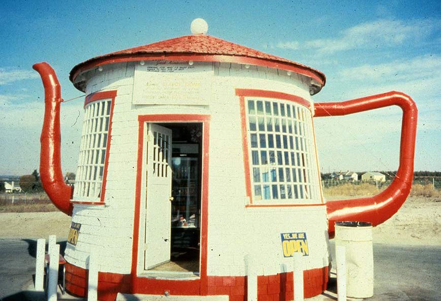
46°35′52″N 120°31′36″W / 46.597778°N 120.526667°WYakima 54 Teapot Dome Service Station 
August 29, 1985 Old State HW 12
46°23′16″N 120°14′02″W / 46.387778°N 120.233889°WZillah 55 Toppenish-Zillah Bridge May 24, 1995 Over the Yakima R., between Toppenish ahd Zillah
46°23′59″N 120°16′49″W / 46.399722°N 120.280278°WToppenish Bridges of Washington State MPS 56 U. S. Post Office and Courthouse 
November 27, 1979 25 S. 3rd St
46°36′07″N 120°30′03″W / 46.601944°N 120.500833°WYakima 57 Union Pacific Freight Building September 8, 1988 104 W. Yakima Ave.
46°36′04″N 120°30′32″W / 46.601111°N 120.508889°WYakima 58 US Post Office-Sunnyside Main May 30, 1991 713 E. Edison Ave.
46°19′25″N 120°00′36″W / 46.323611°N 120.01°WSunnyside 59 US Post Office-Toppenish Main August 7, 1991 14 Jefferson Ave.
46°22′33″N 120°18′40″W / 46.375833°N 120.311111°WToppenish 60 William Watt House February 18, 1987 1511 W. Chestnut Ave.
46°35′47″N 120°31′44″W / 46.596389°N 120.528889°WYakima 61 Dr. Edmond West House February 18, 1987 202 S. Sixteenth Ave.
46°35′46″N 120°31′46″W / 46.596111°N 120.529444°WYakima 62 Charles Wilcox House February 18, 1987 220 N. Sixteenth Ave.
46°36′05″N 120°31′47″W / 46.601389°N 120.529722°WYakima 63 Yakima Indian Agency Building May 19, 1988 1 S. Elm
46°22′44″N 120°18′50″W / 46.378889°N 120.313889°WToppenish 64 Yakima Valley Transportation Company 
October 8, 1992 Third Ave. and Pine St.
46°35′56″N 120°36′09″W / 46.598889°N 120.6025°WYakima 65 Fred and Elizabeth Young House April 1, 2011 804 S. 22nd Ave.
46°35′22″N 120°32′19″W / 46.589444°N 120.538611°WYakima 66 Young Women's Christian Association Building April 29, 1993 15 N. Naches Ave.
46°36′18″N 120°29′57″W / 46.605°N 120.499167°WYakima References
- ^ "National Register of Historic Places: Weekly List Actions". National Park Service, United States Department of the Interior. Retrieved on November 10, 2011.
- ^ Numbers represent an ordering by significant words. Various colorings, defined here, differentiate National Historic Landmark sites and National Register of Historic Places Districts from other NRHP buildings, structures, sites or objects.
U.S. National Register of Historic Places Topics Lists by states Alabama • Alaska • Arizona • Arkansas • California • Colorado • Connecticut • Delaware • Florida • Georgia • Hawaii • Idaho • Illinois • Indiana • Iowa • Kansas • Kentucky • Louisiana • Maine • Maryland • Massachusetts • Michigan • Minnesota • Mississippi • Missouri • Montana • Nebraska • Nevada • New Hampshire • New Jersey • New Mexico • New York • North Carolina • North Dakota • Ohio • Oklahoma • Oregon • Pennsylvania • Rhode Island • South Carolina • South Dakota • Tennessee • Texas • Utah • Vermont • Virginia • Washington • West Virginia • Wisconsin • WyomingLists by territories Lists by associated states Other  Category:National Register of Historic Places •
  Portal:National Register of Historic PlacesCategories:
- National Register of Historic Places in Washington (state) by county
- Yakima County, Washington
-


Wikimedia Foundation. 2010.