- Natural Dam, Arkansas
-
Natural Dam, Arkansas — Unincorporated community — 
 Natural Dam, Arkansas
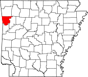
Coordinates: 35°38′55″N 94°23′41″W / 35.64861°N 94.39472°WCoordinates: 35°38′55″N 94°23′41″W / 35.64861°N 94.39472°W Country United States State Arkansas County Crawford Elevation 663 ft (202 m) Time zone Central (CST) (UTC-6) - Summer (DST) CDT (UTC-5) ZIP code 72948 Area code(s) 479 GNIS feature ID 72836[1] Natural Dam is an unincorporated community in Crawford County, Arkansas, United States. Natural Dam is located on Arkansas Highway 59 6 miles (9.7 km) north-northwest of Cedarville. Natural Dam has a post office with ZIP code 72948.[2] Lee Creek Bridge, which is listed on the National Register of Historic Places, is located in the community.[3]
References
- ^ U.S. Geological Survey Geographic Names Information System: Natural Dam, Arkansas
- ^ ZIP Code Lookup
- ^ "National Register Information System". National Register of Historic Places. National Park Service. 2009-03-13. http://nrhp.focus.nps.gov/natreg/docs/All_Data.html.
Municipalities and communities of Crawford County, Arkansas County seat: Van Buren Cities Alma | Cedarville | Kibler | Mountainburg | Mulberry | Van Buren
Towns Unincorporated
communitiesArtist Point | Dora | Natural Dam | Uniontown
Categories:- Populated places in Crawford County, Arkansas
- Unincorporated communities in Arkansas
- Arkansas geography stubs


Wikimedia Foundation. 2010.