- Neunkirchen District, Austria
-
Bezirk Neunkirchen — District — 
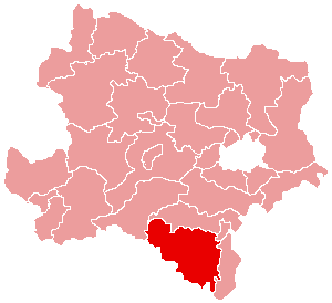
Country Austria State Lower Austria Number of municipalities 45 Area – Total 1,146.4 km2 (442.6 sq mi) Population (2001) – Total 85,769 – Density 74.8/km2 (193.8/sq mi) Time zone CET (UTC+1) – Summer (DST) CEST (UTC+2) NUTS code AT122 Bezirk Neunkirchen is a district of the state of Lower Austria in Austria. It is located at the south-east of the state.
Municipalities
- Parts of the village: Altendorf, Loitzmannsdorf, Schönstadl, Syhrn, Tachenberg
- Parts of the village: Großes Amt, Kleines Amt, Neustift am Alpenwald, Neuwald
- Breitenau
- Breitenstein
- Buchbach
- Bürg-Vöstenhof
- Parts of the village: Bürg, Vöstenhof
- Parts of the village: Enzenreith, Hart, Hilzmannsdorf, Köttlach, Thürmannsdorf, Wörth
- Parts of the village: Feistritz am Wechsel, Grottendorf, Hasleiten, Hollabrunn
- Parts of the town: Abfaltersbach, Aue, Berglach, Eichberg, Gloggnitz (with Furth and Gföhl), Graben, Heufeld, Saloder, Stuppach, Weißenbach
- Parts of the village: Göttschach, Grafenbach, Ober-Danegg, Penk, St. Valentin-Landschach
- Parts of the village: Grimmenstein, Hochegg
- Parts of the village: Grünbach am Schneeberg, Neusiedl am Walde
- Parts of the village: Oberhöflein, Unterhöflein, Zweiersdorf
- Parts of the village: Alpeltal, Kirchberg (with Au, Markt, Molz, Rammergraben, Sachsenbrunn, Sellhof, Stein, Tratten, Weyer, Wieden Wiese), Kranichberg (with Baumtal, Eselberg, Friederdorf, Kiengraben, Oberer Kirchbgraben, Kreith, Kreithberg, Pucha, Pyhra, Rams), Lehen (Ortsteile Nebelsbach, Steinbach), Molzegg (with Kampsteiner Schwaig, Kreuzbauern, Molz, Steyersberger Schwaig), Ofenbach (with Eigenberg, Wieden)
- Parts of the village: Am Hartberg, Feldbauern, Mönichkirchner Schwaig, Pfeffergraben, Tauchen, Unterhöfen
- Parts of the village: Natschbach, Loipersbach (with Lindgrub)
- Parts of the town: Neunkirchen (with Innere Stadt, Tal, Steinplatte, Mühlfeld, Au, Steinfeld, Lerchenfeld, Blätterstraßensiedlung), Mollram, Peisching
- Parts of the village: Geyerhof, Kreuzberg, Küb, Mühlhof, Payerbach, Pettenbach, Schmidsdorf, Schlöglmühl, Werning
- Parts of the village: Pitten, Sautern, Leiding-Inzenhof
- Parts of the village: Gasteil, Prigglitz, Stuppachgraben
- Parts of the village: Knipflitz, Losenheim, Puchberg, Rohrbachgraben, Schneebergdörfl, Sonnenleiten, Stolzenwörth
- Parts of the village: Egg, Raach am Hochgebirge, Schlagl, Sonnleiten, Wartenstein
- Parts of the village: Edlach, Grünsting, Hirschwang, Klein- und Großau, Prein, Reichenau
- Parts of the village: Gleißenfeld, Reitersberg, Scheiblingkirchen, Thernberg, Witzelsberg
- Parts of the village: Göstritz, Greis, Schottwien
- Parts of the village: Greith, Gutenmann, Hornungstal, Rosental, Schrattenbach
- Parts of the village: Guntrams, Schwarzau am Steinfeld
- Ortsteile: Gegend, Naßwald, Preintal, Vois
- Parts of the village: Schiltern, Seebenstein, Sollgraben
- Parts of the village: Gerasdorf am Steinfeld, Neusiedl am Steinfeld, Saubersdorf, St. Egyden am Steinfeld, Urschendorf
- Parts of the village: Dunkelstein, Flatz, Mahrersdorf, Pottschach, Putzmannsdorf, Raglitz, Rohrbach am Steinfelde, St. Johann am Steinfelde, Sieding,
- Parts of the village: Königsberg, Kulma, Sauerbichl, Thomasberg
- Parts of the village: Haßbach, Kirchau, Kulm, Petersbaumgarten, Steyersberg, Thann, Warth
- Parts of the village: Diepolz, Hafning, Ramplach, Straßhof (mit den Ortsteilen Straßhof, Gramatl, Weibnitz), Unter-Danegg und Wartmannstetten
- Parts of the village: Dörfles, Rothengrub, Strelzhof, Willendorf
- Parts of the village: Hettmannsdorf, Wolfsohl, Würflach
- Parts of the village: Grünhöfen, Kampichl, Maierhöfen, Pichl, Schlag, Stübegg, Zöbern
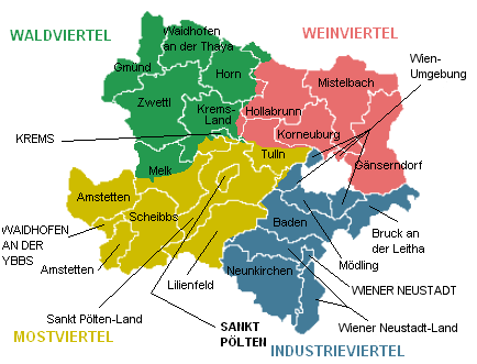
 Cities and districts (Bezirke) of Lower Austria
Cities 
Districts Amstetten • Baden • Bruck an der Leitha • Gänserndorf • Gmünd • Hollabrunn • Horn • Korneuburg • Krems-Land • Lilienfeld • Melk • Mistelbach • Mödling • Neunkirchen • Sankt Pölten-Land • Scheibbs • Tulln • Waidhofen an der Thaya • Wiener Neustadt-Land • Wien-Umgebung • ZwettlCategories:- Districts of Lower Austria
Wikimedia Foundation. 2010.