- Interstate 80 Business (West Wendover, Nevada
-
Interstate 80 Business
Wendover Boulevard 
A map of BL-80 through the two cities, their location on the interstate border and in the United States.Route information Auxiliary route of I-80 Defined by Utah Code §72-4-111 Maintained by City of West Wendover and UDOT Length: 2.26 mi (3.64 km)
0.90 mi (1.45 km) in Nevada[1]
1.363 mi (2.194 km) in Utah[2]History: Established: 1925 (Victory Highway), 1926 (US 40), 1969 (SR-58), 1976 (SR 224), 1980s (BL-80) Major junctions West end: 


 I-80 / US 93 Alt. in West Wendover, Nevada
US 93 Alt. in West WendoverEast end:  I-80 near Wendover, Utah
Location Counties: Nevada: Elko Utah: Tooele Highway system Nevada highways Interstate Highway System
Main • Auxiliary • BusinessState highways in Utah
Interstate • US • State (Parks) • Scenic←  SR 223
SR 225  →
→←  SR-57
SR-57
SR-59  →
→Interstate 80 Business (BL-80) is a business loop of Interstate 80 (I-80) that is 2.26 miles (3.64 km) long and serves as the main street for the towns of West Wendover, Nevada and Wendover, Utah along a roadway named Wendover Boulevard. Wendover Boulevard was originally part of U.S. Route 40 (US 40), which connected California to New Jersey via Nevada and Utah. A portion of the Nevada segment is concurrent with U.S. Route 93 Alternate (US 93 Alt.), and the entire portion in Utah is coterminous with Utah State Route 58 (SR-58). The Nevada Department of Transportation (Nevada DOT) applied for the business loop designation in the early 1980s but the designation has never been approved, despite signs being posted in both states. Between July 1976 and 1993, BL-80 was concurrent with State Route 224 (SR 224) in Nevada.
Contents
Route description
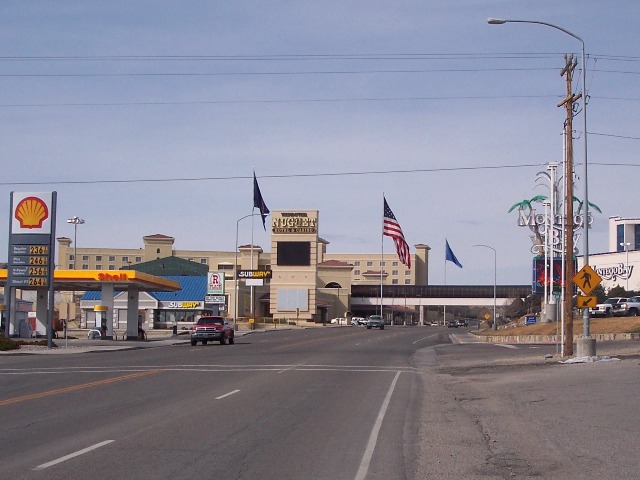
Starting at the easternmost Nevada exit of I-80, BL-80 heads south, concurrent with US 93 Alt. until it intersects and turns east onto Wendover Boulevard. Just west of the intersection, the highway passes the West Wendover City Hall, which houses the West Wendover Municipal Court and Eastline Justice Court.[3] Traveling east along Wendover Boulevard, BL-80 passes by the Peppermill casino, the West Wendover Visitors Center and Scobie Park.[1][4] US 93 Alt. turns south towards Ely, while BL-80 continues east until it reaches the Montego Bay Resort and Wendover Nugget casinos.[4] The casinos are connected via a sky bridge that allows pedestrian access between the hotels without crossing the highway.[5] A line painted on the street marks the Nevada–Utah border.[6] At the border, BL-80 becomes coterminous with Utah State Route 58 for the final stretch through Wendover, Utah.[2]
 BL-80 in Wendover, Utah looking west
BL-80 continues to the east past Aria Boulevard, which to the north connects to I-80, and to the south leads to the historic Wendover Air Force Base, where the Enola Gay was stationed.[7] The highway briefly parallels the Shafter Subdivision of the Union Pacific Railroad's Central Corridor,[8][9] which was formerly part of the Feather River Route of the Western Pacific Railroad.[10] As the highway travels east towards a half trumpet interchange with I-80, the number of lanes drops from five to two. Traffic from BL-80 can access eastbound I-80 or turn off onto Frontage Road; however, to access westbound I-80, travelers must continue eastbound until the next exit and turn around. Traffic into Wendover can access BL-80 from both directions of I-80, and from Frontage Road.[11]
The Utah segment of BL-80 is codified into Utah law as Utah Code §72-4-111.[12] Every year, the Utah Department of Transportation (UDOT) conducts a series of surveys on its highways to measure traffic volume. This is expressed in terms of average annual daily traffic (AADT), which is a measure of average traffic volume for any day of the year. In 2009, UDOT calculated that 2,370 cars traveled on BL-80 at the state line.[13] This is a significant decrease from the traffic counts earlier in the decade, which measured 11,205 cars in 2006, 10,345 cars in 2005, and 13,840 cars in 2004.[14] Twenty-one percent of this traffic consists of trucks.[15]
History
A roadway, now named Wendover Boulevard, has existed since June 23, 1925 when the Victory Highway was completed through Wendover. Then governors George H. Dern of Utah and James G. Scrugham of Nevada, as well as the Secretary of Agriculture William M. Jardine were present to open the highway.[16] Bill Smith and Herman Eckstein opened a filling station at the present location of the Wendover Nugget Casino at a cost of $500 early in 1926.[17] To welcome travelers to his station, he installed a light bulb at the top of a tall pole, which served as the only light in the desert.[18] The Lincoln Highway was routed to follow the Victory Highway through the region by an order of the Lincoln Highway Association executive committee on October 18, 1926.[17]
Wendover Boulevard was numbered US 40 through the cities of West Wendover and Wendover beginning in 1926.[19][20] US 40 was the major thoroughfare between San Francisco, California, in the west and Atlantic City, New Jersey, in the east.[21] US 40 was routed along the Wendover Cut-off,[22] now known as Frontage Road, which was retained as a service road after the completion of the I-80.[23] The US 40 designation was removed by 1976 or 1977, when I-80 was completed through the area.[24] The designation of roadway now numbered US 93 Alt. has changed twice in the past. Between 1932 and 1953,[25][26] it was designated US 50, and between 1954 and either 1978 and 1979,[27][28] it was designated US 50 Alt.
 BL-80 in West Wendover, Nevada, traveling east approaching the Utah state line
Two other roads have been numbered Utah SR-58 in the past. The first route designated SR-58 was formed in 1945 between SR-36 and Clover, but was decommissioned in 1953.[29] The second road to use the designation was formed in 1965 between I-15 in New Harmony back to I-15 via Kanarraville, but that road was decommissioned in 1969.[29] The current SR-58 was codified into Utah law in 1969 between the state line and the junction with Frontage Road, which was formerly US 40.[29] Wendover Boulevard between US 93 Alt. and the state line was designated SR 224 between July 1, 1976, and April 28, 1993, when the highway was transferred to Elko County.[30][31]
Even though BL-80 is signed in both Nevada and Utah, the route has never been officially designated a business loop by the American Association of State Highway and Transportation Officials (AASHTO) or by the Utah State Legislature. Nevada DOT applied for the designation, but in July 1982 the application was deferred by AASHTO until Utah submitted a request for a business loop. No such request has ever been submitted.[32]
Prior to 2007, BL-80 was the only connection to the city of Wendover from Utah. However, a new partial diamond interchange, which allows traffic from I-80 to exit going westbound and for traffic to enter I-80 eastbound,[11] at Aria Boulevard was constructed.[33] The Aria Boulevard interchange was first planned in 2005,[34] and was completed with out using any federal funding.[35]
In 2007, the City of West Wendover had two historical markers installed along BL-80, one at the state line, and the other at the intersection of US 93 Alt. to commemorate the Victory Highway and US 40.[36]
Major intersections
State County Location Mile
[1][2][a]Destinations Notes Nevada Elko West Wendover 0.00
I-80 / US 93 Alt. – Elko, Salt Lake CityWestern terminus 0.28
US 93 Alt. – ElySouth end of US 93 Alt. overlap 0.90
0.000Nevada–Utah state line[b] Utah Tooele Wendover 1.28 Frontage Road (Wendover Cut-off) Former US 40 1.363 I-80 east to I-80 west – Salt Lake CityEastern terminus; east end of SR-58 overlap 1.000 mi = 1.609 km; 1.000 km = 0.621 mi See also
- Interstate 80 Business (Nevada) for other Business Routes of Interstate 80 in Nevada
References
- ^ a b c Nevada Department of Transportation (1993) (PDF). Wendover (Map). Archived from the original on February 9, 2011. http://www.webcitation.org/5wNaCEDVQ. Retrieved February 5, 2009.
- ^ a b c "Route 58" (PDF). Highway Reference. Utah Department of Transportation. May 2008. Archived from the original on February 9, 2011. http://www.dot.utah.gov/main/uconowner.gf?n=6993226563216967. Retrieved 2008-10-08.
- ^ "Municipal & Justice Court". Residents Guide. City of West Wendover. Archived from the original on February 9, 2011. http://www.westwendovercity.com/resguide/municipal_justice_court.php. Retrieved December 8, 2010.
- ^ a b City of West Wendover, Nevada (PDF). West Wendover Street Map (Map). Archived from the original on February 9, 2011. http://www.webcitation.org/5wNaExzND. Retrieved October 8, 2008.
- ^ Bourie, p. 295.
- ^ "Wendover: Where Boom Meets Bust". Deseret News (via NewsBank). July 22, 1990. http://nl.newsbank.com/nl-search/we/Archives?p_product=NewsLibrary&p_multi=DSNB&d_place=DSNB&p_theme=newslibrary2&p_action=search&p_maxdocs=200&p_topdoc=1&p_text_direct-0=0F35FDBEB94363EC&p_field_direct-0=document_id&p_perpage=10&p_sort=YMD_date:D&s_trackval=GooglePM. Retrieved 8 December 2010.
- ^ Vanderbilt pg. 19.
- ^ Sonrisa Publications (2004). Nevada, Utah & Southern Idaho - Railroad Maps (Map). Section B3}. Archived from the original on February 9, 2011. http://www.webcitation.org/5wNaFlnVj. Retrieved December 11, 2010.
- ^ Union Pacific Railroad (PDF). UPRR Common Line Names (Map). Archived from the original on February 9, 2011. http://www.webcitation.org/5wNaG3owH. Retrieved December 8, 2010.
- ^ "Wendover Quick Facts" (PDF). City of West Wendover. July 2009. p. 12. Archived from the original on February 9, 2011. http://www.westwendovercity.com/pdf/WENDOVER%20QUICK%20FACTS-July%202009%20update%202-26-2010.pdf. Retrieved December 8, 2010.
- ^ a b Google, Inc. Google Maps – Utah State Route 58 overview (Map). Cartography by Google, Inc. http://maps.google.com/maps?q=salt+lake+city,+ut&ie=UTF8&oe=utf-8&client=firefox-a&ll=40.74355,-114.019203&spn=0.025426,0.087891&t=p&z=14. Retrieved August 11, 2008.
- ^ "Utah Code §72-4-111". Utah Legislature. Archived from the original on February 9, 2011. http://le.utah.gov/~code/TITLE72/htm/72_04_011100.htm. Retrieved January 16, 2011.
- ^ "Traffic on Utah Highways - 2009" (PDF). Utah Department of Transportation. August 12, 2010. p. 16. Archived from the original on February 9, 2011. http://www.udot.utah.gov/main/uconowner.gf?n=14052524249945136. Retrieved December 3, 2010.
- ^ "Traffic on Utah Highways - 2006" (PDF). Utah Department of Transportation. March 10, 2009. p. 16. Archived from the original on February 9, 2011. http://www.udot.utah.gov/main/uconowner.gf?n=94221010834443783. Retrieved December 3, 2010.
- ^ "Truck Traffic on Utah Highways - 2009" (PDF). Utah Department of Transportation. August 12, 2010. p. 15. Archived from the original on February 9, 2011. http://www.udot.utah.gov/main/uconowner.gf?n=2363733707060508179. Retrieved December 3, 2010.
- ^ Bateman pg. 19.
- ^ a b Bateman pg. xv.
- ^ Toll pg. 46.
- ^ "Transportation Services". Residents Guide. City of West Wendover. Archived from the original on February 9, 2011. http://www.westwendovercity.com/resguide/transportation_ser.php. Retrieved October 9, 2008.
- ^ Rand McNally (1926). Junior Atlas - Utah (Map). Section D. Archived from the original on February 9, 2011. http://www.webcitation.org/5wNaIySh0. Retrieved December 3, 2010.
- ^ United States Department of Agriculture (1926). United States System of Highways (Map). http://upload.wikimedia.org/wikipedia/commons/5/55/1926us.jpg. Retrieved September 26, 2008.
- ^ Patrick, Kevin J.; Wilson, Robert E.. "15 – Lincoln Highway in Utah" (DOC). The Lincoln Highway Resource Guide. Indiana, Pennsylvania: Indiana University of Pennsylvania. p. 193. Archived from the original on February 9, 2011. http://www.webcitation.org/5wNaJreOQ.
- ^ Barker, Clarence S. (April 17, 1965). "State Road Audit Approved". Deseret News: p. B1. http://news.google.com/newspapers/p/deseret_news?id=pFkdAAAAIBAJ&sjid=cVcEAAAAIBAJ&pg=7236,4220199&dq=wendover+%22interstate+80%22&hl=en. Retrieved December 12, 2010.
- ^ Nevada Department of Transportation (1976–1977). Official Highway Map of Nevada (Map). Section B6. Archived from the original on February 9, 2011. http://www.webcitation.org/5wNaMZ4Cw. Retrieved December 3, 2010.
- ^ Nevada Department of Transportation (1932). Road Map of the State of Nevada (Map). Section B7. Archived from the original on February 9, 2011. http://www.webcitation.org/5wNaNtswy. Retrieved December 9, 2010.
- ^ Nevada Department of Transportation (1953). Official Highway Map of the State of Nevada (Map). Section B7. Archived from the original on February 9, 2011. http://www.webcitation.org/5wNaOGzXz. Retrieved December 9, 2010.
- ^ Nevada Department of Transportation (1954). Official Highway Map of the State of Nevada (Map). Section B7}. Archived from the original on February 9, 2011. http://www.webcitation.org/5wNaOcYIQ. Retrieved December 9, 2010.
- ^ Nevada Department of Transportation (1978–1979). Official Highway Map of Nevada (Map). Section B6. Archived from the original on February 9, 2011. http://www.webcitation.org/5wNaP478C. Retrieved December 9, 2010.
- ^ a b c "Route 58" (PDF). Highway Resolutions. Utah Department of Transportation. November 2007. Archived from the original on February 9, 2011. http://www.dot.utah.gov/main/uconowner.gf?n=200609140957431. Retrieved October 8, 2009.
- ^ Nevada's Federal & State Routes: Descriptions & Index. State of Nevada Department of Highways. September 1, 1978.
- ^ "Nevada's State Maintained Highways Description, Index & Maps". NevadaDOT. January 2003. p. 116. Archived from the original on February 9, 2011. http://www.nevadadot.com/traveler/maps/StateMaps/pdfs/maintained_highway.pdf. Retrieved December 29, 2010.
- ^ Francois, Francis E. (July 7, 1982). "NV Request for BL I-80, Alt US 50, BUS US 95 and BUS US 395". American Association of State Highway and Transportation Officials.
- ^ "New Interchange Boon to Wendover, Utah". Coyote TV (West Wendover, NV: High Desert Advocate). November 25, 2007. Archived from the original on February 9, 2011. http://www.coyote-tv.com/index.php?option=com_content&task=view&id=751&Itemid=38. Retrieved December 29, 2010.
- ^ "State of the State". Salt Lake Tribune (via NewsBank): p. B3. April 4, 2005. Archived from the original on February 9, 2011. http://nl.newsbank.com/nl-search/we/Archives?p_product=SLTB&p_theme=sltb&p_action=search&p_maxdocs=200&p_topdoc=1&p_text_direct-0=109501255E04462C&p_field_direct-0=document_id&p_perpage=10&p_sort=YMD_date:D&s_trackval=GooglePM. Retrieved December 28, 2010.
- ^ "Environmental Assessment for the Proposed Aria Boulevard and Interstate 80 Interchange Improvement Project" (PDF). Laramie, WY: TRC. August 7, 2006. pp. 1–1. Archived from the original on February 9, 2011. http://governor.utah.gov/rdcc/Y2006/06-6931.pdf. Retrieved December 28, 2010.
- ^ "Dedication Ceremony to Place Commemorative Markers on Historic Stretch of the Lincoln and Victory Highway Planned March 16, 2007" (Press release). City of West Wendover, Nevada. March 9, 2007. Archived from the original on February 9, 2011. http://www.webcitation.org/5wNaWQARj. Retrieved December 3, 2010.
Works cited
- Bourie, Steve (November 2005). American Casino Guide. Casino Vacations Press. ISBN 978-1-883768-15-7. http://books.google.com/books?id=DIGOHPzw6i4C&pg=PA295.
- Vanderbilt, Tom (April 15, 2010). Survival City: Adventures Among the Ruins of Atomic America. University of Chicago Press. ISBN 978-0-226-84694-1. http://books.google.com/books?id=8gPCq77MoF8C&pg=PA19.
- Toll, David W. (November 2002). The Complete Nevada Traveler, Revised Edition: The Affectionate And Intimately Detailed Guidebook To The Most Interesting State In America. University of Nevada Press. ISBN 978-0-940936-12-6. http://books.google.com/books?id=6G_aRN8VGXQC&pg=PA46.
- Bateman, Ronald R. (2004). Wendover Winds of Change: A History (First ed.). R.R. Bateman. ISBN 0-9745983-1-3.
External links
 Media related to Interstate 80 Business (West Wendover, Nevada – Wendover, Utah) at Wikimedia CommonsCategories:
- Business Interstate Highways
- Transportation in Tooele County, Utah
- U.S. Route 40
- West Wendover, Nevada


Wikimedia Foundation. 2010.