- New Invention, Willenhall
-
For the village in Shropshire, see New Invention, Shropshire.
New Invention is a small suburban commuter village three miles north of the town of Willenhall and four miles east of the city of Wolverhampton in the Metropolitan Borough of Walsall, West Midlands, although formerly South Staffordshire, England. It is situated half way between Walsall and Wolverhampton on the main A4124 and A462 roads.
Contents
History
About the name "New Invention", Timmins notes:
This hamlet owes its strange name to a simple circumstance. The tennant of the first house erected there was annoyed by a smoky chimney, and he contrived an ingenious apparatus to remedy the evil. ... he invited every visitor to see his 'new invention' as he called it. ... it was applied to distinguish his house ... and others ... adopted it also.[1]
Hackwood states that the invention was "a hawthorn bush which was pushed out the top of his chimney."[2]
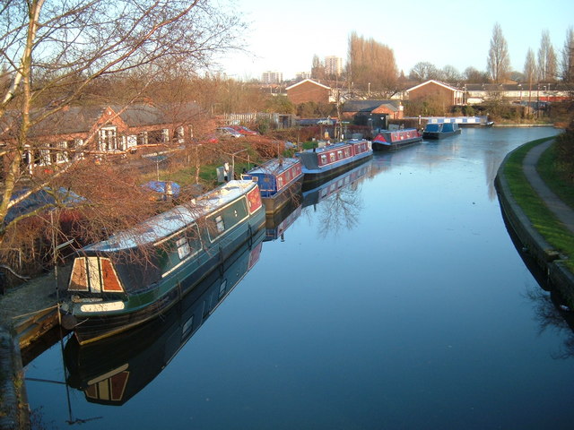
It has rich coal deposits and a significant mining past, with many extensive mines being located in the area during the 19th and early 20th centuries, including primarily 'The Sneyd Colliery'. One present day landmark still running through the village, having extensive ties with the coal mining history of the area, is the Wyrley and Essington Canal. The 'Curly Wyrley' was once used to transport coal via narrowboat to fuel industry in the neighbouring industrial havens of Walsall, Wednesbury and Dudley, seeing that New Invention, and Black Country, coal played a key part in the success of the British Empire. The coal and industry has now disappeared and the canal serves as a scenic walk through woods and green belt land toward the factory lined towpaths of Walsall.
The village also has strong links to the area's lock and key making history, with two major factories formerley being located here, 'Yale' locks and 'Squires' locks. Yale closed during the 1980s and Squires was demolished during the mid-2000's, due to the age of the building, and relocated in Essington. A new housing development has now been built on the land of the former factory.
The urban development of New Invention mainly began during the 1950s; prior to this it was a largely rural settlement dominated mainly by farmland and rural collieries. However, following a population increase in Willenhall and a need for new housing, New Invention was developed. The most recent major housing development to be completed was the Coppice Farm estate, which was mainly built throughout the 1980s and early 1990s.
Methodist preacher John Wesley once stopped in the village after being stoned and forced out of Willenhall, New Invention being, in those days, considerably more isolated from Willenhall than it is today. According to Wesley "I proceeded thence to New Invention, where I met with civility and kindness." Perhaps in recognition of John Wesley part of the present day A462 road is in fact named Wesley Road.
Transport
The village is well served by transport links, being only 3 miles from the M6 motorway - linking it with the North, South and East of the country, and is also close to the M54 motorway - linking the area to the West and Wales.
Despite its relatively small size a large number of public transport services operate in New Invention, due to its location on the main Lichfield Road. These are mostly operated by National Express West Midlands, but also by Diamond Bus and Arriva Midlands:
- 703 New Invention - St Thomas More School (National Express West Midlands)
Term time only school service, running once school-bound and one return
- 28 Wolverhampton - New Invention - Willenhall (National Express West Midlands)
Half hourly Monday - Saturday daytime
- 28E Wolverhampton - New Invention (Midland)
Hourly evening & Sunday service
- X31 Birmingham - New Invention - Cannock (Arriva Midlands)
Express service, running every 60 minutes via the M6 Motorway.
- 41 Walsall - New Invention - Willenhall (National Express West Midlands & Diamond Bus)
Half hourly Monday - Saturday daytime, hourly evenings & Sundays
- 69 Walsall - New Invention - Wolverhampton (National Express West Midlands)
Half hourly Monday - Saturday daytime
- 89 Walsall - New Invention - Wolverhampton (National Express West Midlands)
Half hourly Monday - Saturday daytime, hourly evenings & Sundays
- 326 Bilston - New Invention - Bloxwich (Diamond Bus)
Subsidised service, running every 30 minutes off-peak daytime Monday - Saturday. Several of the early and late journeys terminate in Willenhall
- 560 Wolverhampton - New Invention - Bloxwich (Arriva Midlands/Diamond Bus)
Half hourly Monday - Saturday daytime, hourly evenings & Sundays
These services also link New Invention to Wednesfield, Bentley, Ashmore Park, Cheslyn Hay, Great Wyrley, Pelsall, Beechdale and Lodge Farm estates.
The nearest railway station is Bloxwich railway station and the nearest Midland Metro tram stop is in Wolverhampton.
Facilities
The main shopping area is based around The Square, a small parade with shops on three sides. There is also a Co-op supermarket on Coppice Farm Way and a very popular Tesco Express petrol station on the Lichfield Road (A4124). New Invention Methodist Church serves the area as well as two other churches.
Several pubs in the locality include The Broadway and The Milestone. A former early 18th century inn, 'The Gate', has been redeveloped, after the building began to fail in its former purpose as a public house, and is now a thriving Chinese take-away and award winning Indian restaurant and takeaway, Chilli Peppers.
The area is served by New Invention Library[3] in The Square, which opened in 2007, replacing the old Forest Gate Library (new apartments are to be built on the site of the former library). Two doctors surgeries, New Invention Health Centre (currently being rebuilt) and Sina Health Centre, are located within the village, and there is also a small dentist's practice, the Key Dental Practice, situated within The Square.
Education
The area is also served well by schools, including New Invention Infant School, New Invention Junior School and Beacon Primary School. The nearest Secondary schools are Sneyd Maths and Computing College, located on the border of New Invention and Bloxwich (shortly due to close and be transformed into the country's first University Technical College), and Coppice Performing Arts School on the border with Wednesfield (shortly due to be rebuilt as part of Wolverhampton's Building Schools for the Future programme).
Geography
 Wyrley & Essington Canal
 Sneyd Reservoir
The area has many green spaces including the village green, Coppice Farm open space, the Wyrley & Essington canal, Sneyd reservoir (developed to provide water to the locks of the former Wyrley branch of the canal), Sneyd Wharf and Rough Wood Nature Reserve.
Its proximity to surrounding countryside and greenbelt land on one side of the area, towards Essington and Shareshill, and the urban services of Wolverhampton and Walsall on the other makes it a popular commuter village.
 Sneyd Wharf
References
- ^ Timmins, S., Birmingham and the Midland hardware district, Routledge, 1968, p. 88n.
- ^ Hackwood, FW., The annals of Willenhall, 1908, Reprinted by Echo publications, 2010, p. 148. [1]
- ^ New Invention Library
External links
Categories:


Wikimedia Foundation. 2010.