- Sharlston
-
Coordinates: 53°40′12″N 1°24′48″W / 53.669968°N 1.41346°W
Sharlston 
Sharslton windiling wheel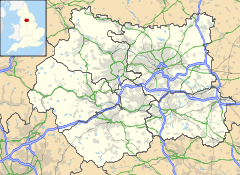
 Sharlston
Sharlston shown within West YorkshirePopulation 2,756 OS grid reference SE3884919437 Parish Sharlston Metropolitan borough City of Wakefield Metropolitan county West Yorkshire Region Yorkshire and the Humber Country England Sovereign state United Kingdom Post town WAKEFIELD Postcode district WF4 Dialling code 01924 Police West Yorkshire Fire West Yorkshire Ambulance Yorkshire EU Parliament Yorkshire and the Humber UK Parliament Hemsworth List of places: UK • England • Yorkshire Sharlston is a village and civil parish situated 4 miles (6.4 km) east of Wakefield in West Yorkshire, England, and includes the settlements of Old Sharlston, Sharlston Common and New Sharlston. Its population at the 2001 census was 2,756.[1] The village lies in the City of Wakefield unitary district.
History
 The White Horse pub at Sharlston.
The village of Old Sharlston has existed for over five hundred years, with the oldest known record indicating that Sharlston Old Hall was built in 1574. In the early 18th century, the village of Sharlston was acquired by the Earl of Westmorland.
Until April 1929, Sharlston formed part of the Warmfield parish, but is now managed by a parish council.
The village of New Sharlston was built after the Stanley Main Pit was closed in 1866. The village consists of two rows of houses which were mostly occupied by the men who worked at the collieries of the surrounding area. Although always a small village, New Sharlston witnessed rapid decline since the 1984-85 miners' strike which hit Sharlston and its surrounding villages hard.
The village has an amateur rugby league team, Sharston Rovers, who recently won the Wakefield Division 2 cup, winning in the final thanks to a single converted try from Morton Hampson. The local professional team is Featherstone Rovers in nearby Featherstone.
The village has had a recent change, that the old peoples home was knocked down and replace with new builds for rent and buy. (2011) The sharlston pub was closed due to unknown reasons, but now has been bought and made into a giant pharmacy.
References
- ^ Office for National Statistics : Census 2001 : Parish Headcounts : Wakefield retrieved 2009-09-11
Categories:- Villages in West Yorkshire
- Geography of Wakefield District
- Civil parishes in West Yorkshire


Wikimedia Foundation. 2010.