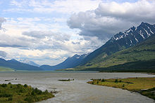
- North American Cordillera
-
The North American Cordillera is the North American portion of the American Cordillera which is a cordillera extending up and down the western side of the Americas. The North American Cordillera covers an extensive area of mountain ranges, intermontane basins, and plateaus in western North America, including much of the territory west of the Great Plains. It is also sometimes called the Western Cordillera, the Western Cordillera of North America, or the Pacific Cordillera.[1][2]
The precise boundaries of this cordillera and its subregions, as well as the names of its various features, may differ depending on the definitions in each country or jurisdiction, and also depending on the scientific field; this cordillera is a particularly prominent subject in the scientific field of physical geography.[3][4] Of all the physiographic features in North America, the North American Cordillera is among the most impressive, and the most diverse.[3][5]
Contents
Major features
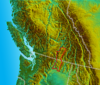
This cordillera extends from the U.S. state of Alaska to the southern border of Mexico. Its mountain ranges generally run north to south along three main belts: the Pacific Coast Ranges to the west, the central Nevadan belt (including the Sierra Nevada), and the Laramide belt to the east (including the Rocky Mountains).[6][7][8] The North American Cordillera includes some of the highest peaks on the continent.[9]
At its midsection between San Francisco, California and Denver, Colorado, this cordillera is about 1,000 miles (1,600 km) wide, and its physiographic provinces at this midpoint are as follows, going from west to east: the Pacific Coast Ranges, the Central Valley, the Sierra Nevada, the Basin and Range province (forming many narrow ranges and valleys), the Colorado Plateau, and the Rocky Mountains.[9] In the United States, another major feature of the Cordillera is the Columbia Plateau, located north of California between the Cascade Range — which is a northern extension of the Sierra Nevada[10] — and the Rocky Mountains.
The Canadian portion of the cordillera likewise includes three primary mountain ranges. They are the Coast Mountains in the west, the Columbia Mountains in the middle, and the Canadian Rockies in the east.[3]
In Mexico, the Sierra Madre Occidental, and the Sierra Madre Oriental to the east, surround the Mexican Plateau.[10][11] To the west, the Peninsular Ranges border the Pacific Ocean, and the Sierra Madre del Sur is the southern extension of the Peninsular Ranges.[12]
Geologic origin
The historical geomorphology and orogenic development of the North American Cordillera is dynamic and controversial, but the paleoenvironmental details provide context on the geography (physical geography, human geography, and biogeography) and how it evolved to its modern state. For example, the Laramide orogeny changed the topography of the central Rocky Mountains and adjoining Laramide regions (from central Montana to central New Mexico) during the Late Cretaceous 80 million years ago.[13] Prior to this time the Rocky Mountain region was occupied by a broad foreland basin. Topographic relief continued to evolve with much activity occurring in the middle Eocene (50-55 million years ago), but since this time the deformation of the region has been relatively stable.[14][15] High altitude formations were common during the Eocene and Oligocene.[15] Orogenic activity is recorded in the Pacific Coastal Mountains (Cascade and Sierra) during the Oligocene, but major uplift did not occur in this area until after the Miocene. The coastal and interior mountains were higher during the Eocene than at present.[16][17]
Pacific Coast Ranges
Main article: Pacific Coast RangesThe Pacific Coast Ranges from southeastern Alaska and southern Yukon parallel the coast 150 to 200 miles (240 to 320 km) inland and comprise several mountain systems, from north to south the Saint Elias Mountains, Coast Mountains, the Insular Mountains, the Olympic Mountains, the Oregon and California Coast Ranges, and the Sierra Nevada. The Cascade Range (called the Cascade Mountains in Canada) is a northern extension of the Sierra Nevada,[10] and the United States Geological Survey excludes both the Sierra Nevada and Cascade Ranges from the Coast Ranges.[18]
Southern Alaska ranges
Main articles: Alaska Range, Saint Elias Mountains, Kenai Mountains, Chugach Mountains, and Talkeetna MountainsYukon Ranges
Main article: Yukon RangesCoast Mountains
Main article: Coast MountainsThe Coast Mountains run from the lower Fraser River and the Fraser Canyon northwestward, separating the Interior Plateau from the Pacific Ocean. Their coastal flank is characterized by an intense network of fjords and associated islands, very similar to the Norwegian coastline, while their inland side against the plateau they transition to the high plateau in dryland valleys notable for a series of large lakes similar to the alpine lakes of southern Switzerland, beginning in deep mountains and ending in flatland. They are subdivided in three main groupings, the Pacific Ranges between the Fraser and Bella Coola, the Kitimat Ranges from there northwards to the Nass River and the Boundary Ranges from there to their terminus in the Yukon Territory at Champagne Pass and Chilkat Pass northwest of Haines, Alaska. The Saint Elias Mountains lie to their west and northwest, while the Yukon Ranges and Yukon Basin lie to their north. On the inland side of the Boundary Ranges are the Tahltan and Tagish Highlands and also the Skeena Mountains, part of the Interior Mountains system, which also extend southwards on the inland side of the Kitimat Ranges.
The terrain of the main spine of the Coast Mountains is typified by heavy glaciation, including several very large icefields of varying elevation. Of the three subdivisions, the Pacific Ranges are the highest and are crowned by Mount Waddington, while the Boundary Ranges contain the largest icefields, the Juneau Icefield being the largest. The Kitimat Ranges are lower and less glacier-covered than either of the other two groupings, but are extremely rugged and dense.
The Coast Mountains are made of igneous and metamorphic rock from an episode of arc volcanism related to subduction of the Kula and Farallon Plates during the Laramide orogeny about 100 million years ago. The widespread granite forming the Coast Mountains formed when magma intruded and cooled at depth beneath volcanoes of the Coast Range Arc whereas the metamorphic formed when intruding magma heated the surrounding rock to produce schist.
Insular Mountains
Main article: Insular MountainsThe Insular Mountains extend from Vancouver Island in the south to the Queen Charlotte Islands in the north on the British Columbia Coast. It contains two main mountain ranges, the Vancouver Island Ranges on Vancouver Island and the Queen Charlotte Mountains on the Queen Charlotte Islands.
Olympic Mountains
Main article: Olympic MountainsOregon Coast Range
Main article: Oregon Coast RangeThe Oregon Coast Range is the part of the Coast Range system that is denoted as between the mouth of the Columbia River and the Middle Fork Coquille River. It is about 200 miles (320 km) long. The highest peak is Marys Peak, at 4,101 ft/1,249m.
California Coast Ranges
Main article: California Coast RangesSierra Madre del Sur
Main article: Sierra Madre del SurThese mountains in southwestern Mexico form a southern extension of the Peninsular Ranges of Baja, California.[12]
Nevadan belt
The Nevadan belt is located between the Coast Ranges and the Laramide belt.
Northern Interior Mountains
Main article: Interior MountainsThe Northern Interior Mountains in Canada are a northern extension of the Columbia Mountains.[19]
Columbia Mountains
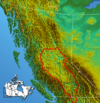
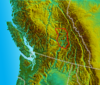
 Location map
 Main article: Columbia Mountains
The Columbia Mountains are a designation in British Columbia for a group of four ranges lying between the Rocky Mountain Trench and the Interior Plateau. These are the Cariboo Mountains, which are the northernmost and sometimes considered to be part of the Interior Plateau, the Selkirk Mountains, the Purcell Mountains, and the Monashee Mountains.
The Columbia Mountains are classified as being in Canada's interior system, rather than its eastern system.[20] However, the Columbia Mountains are an extension of mountains in the United States that are considered part of the Rocky Mountains, and therefore the Columbia Mountains are often treated as being part of the Rockies.[21]
The Selkirks and Purcells lie entirely within the basin of the Columbia River, while the Monashees lie to the river's west on its southward course from its Big Bend and are flanked on the west by the basin of the Thompson and Okanagan Rivers. There are many named subranges of all four subgroupings, particularly in the Selkirks and Monashees. The southward extension of the Selkirks, Purcells and Monashees into the United States are reckoned to be part of the Rocky Mountains and the designation Columbia Mountains is not used there (the Purcells, also, go by the name "Percell Mountains" in the United States). The Salish and Cabinet Mountains south of the Kootenai River are essentially part of the same landform, but are officially designated part of the Rocky Mountains in the United States.
 Monashee Mountains
To the west of the Monashees and Cariboos, there are three intermediary upland areas which are transitional between the mountain ranges and the plateaus flanking the Fraser and Thompson Rivers. These - the Quesnel, Shuswap and Okanagan Highlands, are sometimes considered as being part of the neighbouring ranges rather than the plateaus and are often spoken of that way locally but are formally designated as being part of the Interior Plateau. The southernmost extends into the Washington, where it is named by the American spelling Okanogan Highland (and was the first-named of these groupings).[20]
Cascade Range
Main article: Cascade RangeThe Cascade Range (called the Cascade Mountains in Canada) is distinct from the Coast Ranges. The Cascade Range extends from Northern California, United States to southern British Columbia, Canada. It consists of non-volcanic and volcanic mountains: all of the known historic eruptions in the contiguous United States have been from the volcanoes of the Cascade Volcanic Arc. The highest peak in the Cascade Range is Mount Rainier (4,392 metres (14,409 ft), a stratovolcano. The small portion of the Cascade Range in Canada is called the Cascade Mountains or Canadian Cascades, and in its southwestern area is similar in terrain to the area north of Glacier Peak, known as the North Cascades, and its northern and eastern extremities verge on the Thompson Plateau in a less rugged fashion than in most other parts of the range. The North Cascades are very different in character from the series of high volcanic stratovolcanoes from Rainier southwards to Mounts Shasta and Lassen, and is more severely alpine and steeply rugged, particularly the Hozomeen Range. Inland portions of the range are dryland and plateau-like in character, e.g. the Okanagan Range, which lies along the Cascades' northeastern margin, separated by the Similkameen River.
Sierra Nevada
Main article: Sierra Nevada (U.S.)The Sierra Nevada form an inland mountain spine of California running south from the area of the terminus of the Cascade Range near Mount Lassen along the east flank of the Central Valley of California to the Mojave Desert, forming a mountain region of complex terrain and varied geology which separates the Central Valley from the Great Basin which lies inland to the east. The height of the mountains in the Sierra Nevada gradually increases from north to south, culminating at Mount Whitney (4,421 metres (14,505 ft)), the highest point in the Continental United States. From east to west, the Sierra are shaped like a trapdoor: the west slope gradually rises, and the east slope forms a steep escarpment.
The northern Sierra are predominately volcanic rock, while the southern Sierra are granite (formed deep underground in the Jurassic period), and then subsequently sculpted by glaciers into dramatic U-shaped valleys and aretes.
Sierra Madre Occidental
Main article: Sierra Madre OccidentalThese mountains may be considered a southern extension of the Sierra Nevada.[22]
Laramide belt
The Laramide belt is at the opposite side of the North American Cordillera from the Pacific Coast Ranges.
Brooks Range
 The Brooks RangeMain article: Brooks Range
The Brooks Range are the northernmost of the major mountain systems of the North American Cordillera, and extend along an east-west axis across northern Alaska from near the northern opening of the Bering Strait to the northern Yukon Territory. Major subranges include the British Mountains and Richardson Mountains, towards their eastern end, and at their farthest west is the small subrange that De Long Mountains. The Brooks Range forms the northern flank of the lower Yukon River basin, separating it from Alaska's North Slope region, facing the beaufort Sea. The Brooks Range is considered part of (or an extension of) the Rockies.[23][24][25]
Ranges of Canada's Eastern System
Mackenzie Mountains
Main article: Mackenzie MountainsCanadian Rocky Mountains
Main article: Canadian RockiesRocky Mountains in United States mainland
Main articles: Geography of the United States Rocky Mountain System and Rocky MountainsThe range's highest peak is Mount Elbert in Colorado at 4,401 metres (14,439 ft) above sea level. The American Rockies rise steeply over the Interior Plains to the east, and over the Great Basin to the west, and extend south to the Rio Grande in New Mexico. Other mountain ranges continue as far north as the Selwyn Range in Yukon and the Brooks Range in Alaska, and likewise the Sierra Madre in Mexico extends south, but none of those mountains are considered part of the American Rockies. The United States definition of the Rockies includes the Cabinet and Salish Mountains of Idaho and Montana, whereas their counterparts north of the Kootenai River, the Columbia Mountains, are sometimes considered a separate system lying to the west of the huge Rocky Mountain Trench which runs the length of British Columbia.[26]
Sierra Madre Oriental
Main article: Sierra Madre OrientalThese mountains in eastern Mexico are often considered a southern extension of the Rocky Mountains.[27][25]
Intermontane areas
Main article: Interior SystemInterior Plateau
 Main article: Interior Plateau
The Interior Plateau is the northern continuation of the Columbia Plateau, covering much of inland British Columbia. The Cariboo Mountains and Monashee Mountains lie to the east, the Canadian Cascades are to the southwest, and the Hazelton Mountains and Coast Range to the west and northwest.[28]
Shuswap Highland
 Main article: Shuswap Highland
The Shuswap Highland consists of a portion of the foothills between the Thompson Plateau and Bonaparte Plateau on the west, and the Monashee Mountains and Cariboo Mountains on the east and northeast.[29]
Thompson Plateau
 Main article: Thompson Plateau
The Thompson Plateau forms the southern portion of the Interior Plateau. It is bordered on the south by the Canadian Cascades and on the north by the Thompson River.[30]
Okanagan Highland
 Main article: Okanagan Highland
The Okanagan Highland is to the east of the Thompson Plateau, and is bounded by the Okanagan River on the west, the Shuswap River on the north, and the Kettle River on the east side. The Okanagan Highland is described as being a hilly plateau, and is located in southern British Columbia and northern Washington.[31]
Columbia Plateau
Main article: Columbia PlateauBasin and Range province
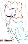 Main article: Basin and Range province
The Basin and Range province covers most of the state of Nevada and parts of the states of Arizona, California, Idaho, New Mexico, Oregon, Texas, Utah, and Wyoming, as well as much of northern Mexico. It is an extremely arid region characterized by basin and range topography.[32]
Colorado Plateau
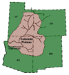 Main article: Colorado Plateau
The Colorado Plateau is an area of high desert located in Arizona, New Mexico, Colorado, and Utah, bisected by the Colorado River which flows westward through the southern part, and the Green River which flows south from the northernmost part of the plateau. The Green is a tributary of the Colorado, the confluence being west of Moab, Utah in Canyonlands National Park.[33]
Summaries for each national jurisdiction
Alaskan portion
Generally speaking, Alaska has four physiographic regions. In the north part of the state, there is the Interior Plains area, and the three areas to the south of that are part of the North American Cordillera. Those three areas are the Rocky Mountain System, the Intermontane Basins and Ranges, and in the southern part of the state are the Pacific Mountains and Valleys.[34] In the Alaska panhandle, the mainland mountain ranges and offshore islands (the Alexander Archipelago) are extensions of respective ranges further south.[35]
Canadian portion
In Canada, the North American Cordillera is usually divided into three physiographic regions: the western system, the interior system, and the eastern system.[36] The Canadian portion of the cordillera begins in the north at the Brooks Range and De Long Mountains of Northern Alaska.[37] The area extends south through the diverse topography of the Yukon Territory and British Columbia - the Saint Elias Mountains and Coast Mountains along the Pacific coast. In the Yukon the Yukon Ranges and Yukon Plateau lie to the northeast of the Saint Elias Mountains and to the north and east of the Coast Mountains, beyond which the eastern part of the cordillera comprises the Selwyn Mountains, forming the spine of the border between the Yukon and the Northwest Territories, and the Mackenzie Mountains. In British Columbia, inland from the Coast Mountains lie the Interior Mountains, Interior Plateau and Columbia Mountains, comprising what is known in Canada as the Interior System, to the Canadian Rockies, which form the southern half of the boundary between British Columbia and Alberta and are the British Columbia component of the eastern part of the cordillera.[38]
Contiguous United States portion
Mexican portion
See also
References
- ^ R. Saager and F. Bianconi. (1971). The Mount Nansen gold-silver deposit, Yukon territory, Canada. Mineralium Deposita, 6(3): 209-224
- ^ D. S. Cowan. (1985). Structural styles in Mesozoic and Cenozoic melanges in the Western Cordillera of North America. Geological Society of America Bulletin 96, no. 4: 451-462
- ^ a b c Ostopowich, Melanie. The Cordillera, pp. 6, 12, and 20 (DIANE Publishing 2005): "The Cordillera is one of the seven geographic regions in Canada".
- ^ The Encyclopedia Americana: a library of universal knowledge, page 687 (Encyclopedia Americana Corp., 1918): "[N]ame from the Spanish....It is used particularly in physical geography, although in geology also it is sometimes applied...."
- ^ Delson, Eric et al. Encyclopedia of human evolution and prehistory, page 93 (Taylor & Francis, 2000): "The most impressive physiographic feature in North America is the western cordillera."
- ^ A. J. Eardley. (1967). Western Cordillera--Alaska to Mexico: ABSTRACT. AAPG Bulletin, Volume 51.
- ^ T. O. Tobisch, S. R. Paterson, S. Longiaru, T. Bhattacharyya. (1987). Extent of the Nevadan orogeny, central Sierra Nevada, California. Geology, 15(2):132
- ^ P. J. Coney and T. A. Harms. (1984). "Cordilleran metamorphic core complexes: Cenozoic extensional relics of Mesozoic compression". Geology, 12:550-554.
- ^ a b Press, Frank and Siever, Raymond. Earth, pages 534-535 (Macmillan 1986).
- ^ a b c Merriam-Webster's Geographical Dictionary, pp. 219 and 1087 (Merriam-Webster 1997)
- ^ Sinha, Shatrughna and Ram, Faguni. Instant Encyclopaedia of Geography, page 140 (Mittal Publications 1993)
- ^ a b Encyclopedia Americana: the International Reference Work, Volume 18: “Sierra Madre del Sur. — This sierra, which crosses the states of Colima, Michoacan, Guerrero, and Oaxaca, is the continuation of the Sierra de Baja California and the other mountain ranges linked with it.” (Americana Corporation 1961).
- ^ M. E. McMillan, P. L. Heller, and S. L. Wing. (2006). History and causes of post-Laramide relief in the Rocky Mountain orogenic plateau. Geological Society of America Bulletin 118, no. 3-4: 393-405.
- ^ W. R. Dickinson, M. A. Klute, M. J. Hayes, S. U. Janecke, E. R. Lundin, M. A. McKittrick, and M. D. Olivares. (1988). Paleogeographic and paleotectonic setting of Laramide sedimentary basins in the central Rocky Mountain region: Geological Society of America Bulletin, v. 100 p. 1023-1039
- ^ a b J. A. Wolfe, C. E. Forest, and P. Molnar. (1998). Paleobotanical evidence of Eocene and Oligocene paleoaltitudes in midlatitude western North America. GSA Bulletin, 110(5): 664-678
- ^ D. Alt and D. Hyndman. (1995). Northwest Exposures: A Geological Story of the North West. Mountain Press Publishing Company, Missoula, Montana
- ^ Brunsfeld, S., Sullivan, J., Soltis, D., Sotis, P., 2001. Comparative phylogeography of north-western north america: A synthesis. In: Silverton, J., Antonovics, J. (Eds.), Integrating Ecology and Evolution in a Spatial Context. The 14th Special Symposium of the British Ecological Society. British Ecolological Society, Blackwell Science Ltd., Ch. 15, pp. 319–339.[1]
- ^ "Coast Ranges". Geographic Names Information System, U.S. Geological Survey. http://geonames.usgs.gov/pls/gnispublic/f?p=gnispq:3:::NO::P3_FID:252293. Retrieved 2007-07-30.
- ^ Parsons, M. and Quinn, O. “Insular and Coastal Mountains, Interior Mountains”, Canadian Ministry of Environment: “Interior Mountains comprising the Columbia Mountains of the southern interior and the Omineca, Cassiar, Skeena and Hazelton Mountains of the northern interior.”
- ^ a b S. Holland, Landforms of British Columbia, BC Govt, 1976
- ^ Cannings, Richard. The Rockies: A Natural History, page 5 (Greystone/David Suzuki Foundation 2007).
- ^ Merrill, Tim et al. Mexico: A Country Study, p. 80 (Library of Congress, Federal Research Division, Claitors Pub Div. 2005): "The Sierra Madre Occidental on the west is a continuation of California's Sierra Nevada (with a break in southeastern California and extreme northern Mexico)…."
- ^ The Encyclopedia Americana, Volume 23, page 618 (Grolier 2000).
- ^ Safire, William. The New York Times guide to essential knowledge: a desk reference for the curious mind, page 623 (Macmillan 2007 ).
- ^ a b Bridges, Edwin. World Geomorphology, page 88 (Cambridge University Press 1990).
- ^ Cannings, Richard (2007). The Rockies: A Natural History. Greystone/David Suzuki Foundation. p. 5. http://books.google.com/books?id=ig4OMokvt-0C&pg=PA5&dq=%22Rocky+Mountain+Trench%22+and+%22Columbia+Mountains%22&hl=en&ei=ITPGTYH6MNOdgQf5zIXLBA&sa=X&oi=book_result&ct=result&resnum=6&ved=0CH0Q6AEwBQ#v=onepage&q=%22Rocky%20Mountain%20Trench%22%20and%20%22Columbia%20Mountains%22&f=false.
- ^ "Sierra Madre Oriental", Encyclopædia Britannica Online (2011).
- ^ Interior Plateau in the BCGNIS (British Columbia Geographic Names Information System)
- ^ Shuswap Highland in the BCGNIS (British Columbia Geographic Names Information System)
- ^ Thompson Plateau in the BCGNIS (British Columbia Geographic Names Information System)
- ^ Okanagan Highland in the BCGNIS (British Columbia Geographic Names Information System)
- ^ "Boundary Descriptions and Names of Regions, Subregions, Accounting Units and Cataloging Units". U.S. Geological Survey. http://water.usgs.gov/GIS/huc_name.html. Retrieved 2010-10-23.
- ^ Colorado Plateau in the GNIS (Geographic Names Information System)
- ^ The Geography of Alaska: Physical Geography, Alaska Humanities Forum: “At a very general level, Alaska is part of four general physiographic regions, the Interior Plains, Rocky Mountains, Intermontane Basins and Ranges, and the Pacific Mountains and Valleys”.
- ^ Wheeler, J. and Kostbade, J. World Regional Geography (Saunders College Publishing 1990): “The mainland ranges of the panhandle are a northward extension of the cascade range and the British Columbia Coastal ranges, while the mountainous offshore islands are an extension of the Coast Ranges of the Pacific Northwest and the islands of British Columbia.”
- ^ Bailey, William et al. The surface climates of Canada, page 226 (McGill-Queen's Press - MQUP 1997).
- ^ A. J. Martin. (1970). Structure and Tectonic History of the Western Brooks Range, De Long Mountains and Lisburne Hills, Northern Alaska. Geological Society of America Bulletin 81, no. 12: 3605-3622.
- ^ Some categorizations describe the Selwyns and Mackenzies as an extension of the Rockies, but this is not part of the official toponymy.
Subfields of physical geography  Categories:
- Western Cordillera (North America)
- Mountain ranges of North America
- Geologic provinces of Canada
- Geologic provinces of the United States
- Geology of Mexico
- Mountain ranges of Canada
- Mountain ranges of the United States
- Mountain ranges of Mexico


Wikimedia Foundation. 2010.