- North American Environmental Atlas
-
The North American Environmental Atlas is an interactive mapping tool created through a partnership of government agencies in Canada, Mexico and the United States, along with the Commission for Environmental Cooperation, a trilateral international organization created under the North American Agreement on Environmental Cooperation (NAAEC). By "mapping North America's shared environment," the Atlas depicts environmental issues from a continental perspective.
Contents
Purpose
The North American Environmental Atlas builds on information created, gathered, and harmonized by government scientists and map makers from Natural Resources Canada, the United States Geological Survey, and Mexico's Instituto Nacional de Estadística y Geografía. Each country's contributing team works closely with their partner agencies in the other countries to ensure seamless and harmonized data.
The Atlas provides a foundation to analyze the status of environmental conditions and identify significant trends across North America. It contains data on watersheds, terrestrial and marine ecoregions and protected areas, industrial pollution, human impact, and base layers including transportation and waterways. The Commission for Environmental Cooperation uses these geospatial data to identify priority areas to conserve biodiversity, track cross-border pollution, monitor carbon emissions across major transportation routes, and predict the spread of invasive species
Map Information
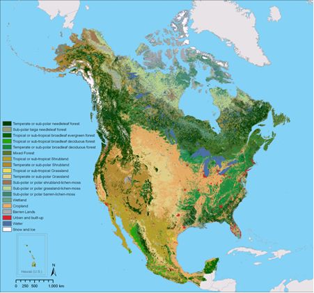
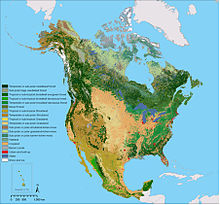 A map layer showing land cover for the year 2005
Information included in the Atlas includes accurate, seamless maps, documentation, and geospatial data that crosses political borders. This data is displayed as series of interactive map layers in an easy to use map viewer format.
Most layers in the North American Environmental Atlas are at a scale of 1:1:10,000,000 or finer.
The variety of layers in the Atlas continues to expand in order to support analysis of environmental conditions. Increasingly, data are being made compatible with tools such as Google Earth and ArcGis On-line/Arc Explorer. The entire collection of maps, data, and downloadable files is available for free online at the CEC website.
Ecoregions
Main article: List of ecoregions in North America (CEC)Number CEC Name American equivalent Canadian equivalent Mexican equivalent WWF equivalent 1. Arctic Cordillera " 2. Tundra 3. Taiga 4. Hudson Plains 5. Northern Forests 6. Northwestern Forested Mountains 7. Marine West Coast Forests 8. Eastern Temperate Forests 9. Great Plains Prairies Ecoregion 10. North American Deserts 11. Mediterranean California 12. Southern Semi-Arid Highlands 13. Temperate Sierras 14. Tropical Dry Forests 15. Tropical Humid Forests See also
External links
Categories:- Trilateral relations of Canada, Mexico, and United States
- Atlases
- Natural Resources Canada
- United States Geological Survey
Wikimedia Foundation. 2010.