- North Fork Clearwater River
-
North Fork Clearwater River North Fork of the Clearwater River River 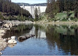 Dworshak Dam on the North Fork Clearwater, near its mouth
Country United States State Idaho Tributaries - right Little North Fork Clearwater River Source Bitterroot Mountains - location Illinois Peak, Shoshone County - elevation 5,400 ft (1,646 m) - coordinates 47°00′11″N 115°06′16″W / 47.00306°N 115.10444°W Mouth Clearwater River - location Ahsahka, Clearwater County - elevation 980 ft (299 m) - coordinates 46°30′00″N 116°19′50″W / 46.5°N 116.33056°W Length 135 mi (217 km) Basin 2,462 sq mi (6,377 km2) Discharge for Clearwater River - average 5,687.5 cu ft/s (161 m3/s) - max 110,000 cu ft/s (3,115 m3/s) - min 799 cu ft/s (23 m3/s) The North Fork Clearwater River is a major tributary of the Clearwater River in the U.S. state of Idaho.[1] From its headwaters in the Bitterroot Mountains of eastern Idaho, it flows 135 miles (217 km)[2] southwest, north, then again southwest, and is dammed by the Dworshak Dam just above its mouth at the Clearwater in central Idaho. Draining 2,462 square miles (6,380 km2) of mountainous and scantly populated terrain, the river has an average flow of over 3,510 cubic feet per second (99 m3/s) at its mouth, over one-fifth of the average flow of the Clearwater.[3] The river drains parts of Clearwater, Shoshone, Latah, and Idaho counties, on primarily U.S. Forest Service land.
Contents
Course
It rises in the Bitterroot Mountains, which form the far eastern border of the State of Idaho, on the Idaho-Montana border. The headwaters are on the south flank of the triple summits of Graves Peak, Illinois Peak and Gold Crown Peak, very near a small pond that is the source of the St. Joe River, which flows into Coeur d'Alene Lake. The river immediately flows southwest through a narrow gorge, joined by numerous small tributaries. The river turns southeast to join Long Creek and Lake Creek, which flow in from the east. After joining these two large creeks, the river turns west, then receives Elizabeth Creek from the right as it veers to the south. It then flows at a 90-degree angle into a wider valley, where it receives its largest tributary thus far, 25-mile (40 km) Kelly Creek,[4] from the left near an unincorporated community, and turns west and southwest, paralleled by Forest Service Road #250. It then receives Quartz Creek from the right.[5]
Flowing northeast then swinging back west, the river receives Skull Creek from the northeast just downstream of the Quartz Creek confluence. Beaver Creek enters from the south and Isabella Creek from the north. With high buttes towering to the north and comparatively gradual mountains rising on the south, the river enters Dworshak Reservoir, formed by the massive Dworshak Dam.[6] About 8 miles (13 km) later, the flooded canyon meets the canyon of the Little North Fork Clearwater River on the right, which is also flooded for some distance. Still narrow and winding, following the river's original course, the reservoir branches to the south and spreads wider as it enters more gradual terrain. Reeds Creek enters as the canyon swings west, and an arm of the reservoir branches off to flood part of the Elk Creek Canyon to the north. The reservoir then ends at the Dworshak Dam, a 717 ft (219 m) high concrete gravity dam. Exiting the dam the river runs east-southeast, crosses under Idaho State Route 7, and meets the Clearwater River at Ahsahka.[5]
Watershed
The North Fork Clearwater's watershed covers 2,462 square miles (6,380 km2) of land in the lower Idaho Panhandle. The watershed is approximately 26.6 percent of the 9,645-square-mile (24,980 km2) Clearwater River watershed, itself a tributary of the Snake River. The drainage area of the St. Joe River abuts the North Fork drainage to the north, Latah Creek to the northeast, the Middle Fork Clearwater to the east and south, the South Fork Clearwater and Snake River to the south, and the Potlatch River and Clearwater to the west. The basin is very lightly populated - the largest and only incorporated town is Elk River, Idaho, population 149. The logging industry makes up the primary economy of the North Fork's watershed.[7]
The major tributaries to the North Fork Clearwater River are (proceeding downstream) Kelly Creek,[8] the Little North Fork Clearwater River,[9] and Elk Creek.[10]
On average, streamflow in the North Fork is approximately 5,200 cubic feet per second (150 m3/s), ranging from 1,000 cubic feet per second (28 m3/s) to over 30,000 cubic feet per second (850 m3/s).[11] The USGS operated a stream gauge near the mouth of the river from 1927 to 1968. In that time period, the highest recorded flow was 100,000 cubic feet per second (2,800 m3/s) on December 23, 1933. The lowest peak was 12,200 cubic feet per second (350 m3/s) on 18 May 1941.[12]
References
- ^ "North Fork Clearwater River". Geographic Names Information System, U.S. Geological Survey. 1979-06-21. http://geonames.usgs.gov/pls/gnispublic/f?p=gnispq:3:::NO::P3_FID:387675. Retrieved 2009-08-05.
- ^ U.S. Geological Survey. National Hydrography Dataset high-resolution flowline data. The National Map, accessed May 3, 2011
- ^ "North Fork Clearwater River Basin". Idaho Department of Water Resources. www.idwr.idaho.gov. http://www.idwr.idaho.gov/WaterBoard/WaterPlanning/CompBasinPlanning/Clearwater%20NF/clearwater-nf.htm. Retrieved 2009-08-05.
- ^ Robbins, p. 65.
- ^ a b Google Maps (2009). Map of the North Fork Clearwater River (Map). Cartography by NAVTEQ. http://maps.google.com/. Retrieved 2009-08-05.
- ^ Benke and Cushing, p. 632
- ^ "North Fork Clearwater Basin". Idaho Department of Water Resources. Comprehensive State Water Plan Executive Summary. http://www.idwr.idaho.gov/WaterBoard/WaterPlanning/CompBasinPlanning/Clearwater%20NF/Documents/exec_summary.pdf. Retrieved 2009-08-05.[dead link]
- ^ U.S. Geological Survey Geographic Names Information System: Kelly Creek
- ^ U.S. Geological Survey Geographic Names Information System: Little North Fork Clearwater River
- ^ U.S. Geological Survey Geographic Names Information System: Elk Creek
- ^ "Upper North Fork Clearwater River Subbasin Assessment and Total Maximum Daily Loads". Idaho Department of Environmental Quality. www.deq.state.id.us. 2003-10. http://www.deq.state.id.us/water/data_reports/surface_water/tmdls/clearwater_river_unf/clearwater_river_unf_apps1to5.pdf. Retrieved 2009-08-05.
- ^ "USGS Gage #13341000 on the North Fork Clearwater River at Ahsahka, Idaho". National Water Information System. United States Geological Survey. 1927-1968. http://nwis.waterdata.usgs.gov/nwis/peak?site_no=13341000&agency_cd=USGS&format=html. Retrieved 2009-08-05.
Works cited
- Benke, Arthur C.; Cushing, Colbert E. (2005). Rivers of North America. Academic Press. ISBN 0-12088-253-1.
- Robbins, Chuck (2003). On the Fly Guide to the Northern Rockies. Wilderness Adventures Press. ISBN 1-93209-801-1.
Categories:- Rivers of Idaho
- Tributaries of the Snake River
- Landforms of Shoshone County, Idaho
- Landforms of Clearwater County, Idaho
- Landforms of Latah County, Idaho
- Landforms of Idaho County, Idaho

Wikimedia Foundation. 2010.