- North Island Fault System
-
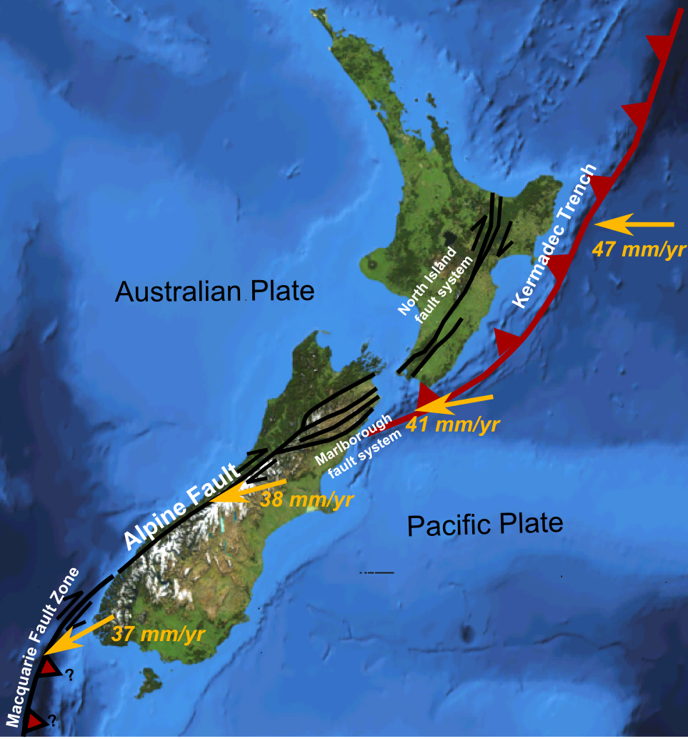
 Major active fault zones of New Zealand showing variation in displacement vector of Pacific Plate relative to Australian Plate along the boundary
 Main active strands of the North Island Fault System
The North Island Fault System or North Island Dextral Fault Belt is a set of southwest-northeast trending seismically-active faults in the North Island of New Zealand that carry most of the dextral (right lateral) strike-slip component of the oblique convergence of the Pacific Plate with the Australian Plate. They include the Wairarapa Fault and Wellington Fault to the southwest, the Ruahine and Mohaka Faults in the central section and the Waimana, Waiotahi, Whakatane and Waiohau Faults to the northeast. Most of the fault system consists of dextral strike-slip faults, although towards its northeastern end the trend swings to more S-N trend and the faults become mainly oblique normal in sense as the zone intersects with the Taupo rift zone. This fault zone accommodates up to 10 mm/yr of strike-slip displacement.[1]
Contents
Faults
The North Island Fault System consists of eight main fault strands and many other smaller related faults.
Wellington Fault
Main article: Wellington FaultThe Wellington Fault is a dextral strike-slip fault that runs from the Cook Strait on the southern coast of North Island up to near Woodville, where the fault branches into the Mohaka and Ruahine Faults. No historical earthquakes have been recorded along this fault although a significant event is estimated to have occurred within the last 1,000 years. The recurrence interval for large earthquakes on this fault is estimated to be less than 2,000 years.[2] Three main segments have been identified, the Wellington-Hutt section, the Tararua section and the Pahiatua section.[3][4]
Wairarapa Fault
Main article: Wairarapa FaultThe Wairarapa Fault extends from near the coast just southwest of Lake Wairarapa, running along the lake's northwestern edge. The 1855 Wairarapa earthquake was caused by movement along this fault. The recurrence interval for large earthquakes on this fault is less than 2,000 years.[2]
Ruahine Fault
As the Wellington Fault branches near Woodville, the more northwesterly branch is known as the Ruahine Fault. Results from trenching over this fault suggest an earthquake recurrence interval of 400–500 years, with typical offsets in the range 3.0–5.5 m.[5] At its northern end this fault becomes the Waiohau Fault.[1]
Mohaka Fault
The more southeasterly branch of the Wellington Fault is known as the Mohaka fault. The fault splays to the north, onto the Waimana Fault, which itself branches into the Waiotahi and Waioeka Faults, the main segment of the Mohaka Fault eventually passes into the Whakatane Fault.[1]
References
- ^ a b c Mouslopoulou, V.; Nicol, A.; Little, T.A.; Begg J.A. (2009). "Palaeoearthquake surface rupture in a transition zone from strike-slip to oblique-normal slip and its implications to seismic hazard, North Island Fault System, New Zealand". In Reicherter K., Michetti A.M. & Silva P.G.. Palaeoseismology: historical and prehistorical records of earthquake ground effects for seismic hazard assessment. Special Publications. 316. London: Geological Society. pp. 269–292. ISBN 9781862392762. http://books.google.co.uk/books?id=9Kwd1tbI64oC&printsec=frontcover&dq=Palaeoseismology:+Historical+and+Prehistorical+Records+of+Earthquake+Ground+Effects+for+Seismic+Hazard+Assessment&hl=en&ei=N1qoTK2yCIjtOdy8pLkM&sa=X&oi=book_result&ct=result&resnum=1&ved=0CDAQ6AEwAA#v=onepage&q&f=false. Retrieved 3 October 2010.
- ^ a b NGS Science. "New Zealand Active Faults Database". http://data.gns.cri.nz/af/index.jsp. Retrieved 4 October 2010.
- ^ Langridge, R.M.; Berryman K.R. & van Dissen R.J. (2005). "Defining the geometric segmentation and Holocene slip rate of the Wellington Fault, New Zealand: the Pahiatua section". New Zealand Journal of Geology & Geophysics 48: 591–607. http://www.royalsociety.org.nz/media/publications-journals-nzjg-2005-043-lo.pdf. Retrieved 6 October 2-1-.
- ^ Van Dissen, R.J.; Berryman, K.R. (1996). "Surface rupture earthquakes over the last ~1000 years in the Wellington region, New Zealand, and implications for ground shaking hazard". Journal of geophysical research. Solid earth 101(B3): 5999–6019. http://www.agu.org/pubs/crossref/1996/95JB02391.shtml. Retrieved 4 October 2010.
- ^ Neall, V.E.; Hanson J.A.. "The Neotectonics of the Ruahine and Mohaka Faults, between the Manawatu Gorge and Puketitiri and Figures to Accompany Final Prog". Research Paper 971. Earthquake Commission. http://www.eqc.govt.nz/research/researchpapers/p_971.aspx. Retrieved 6 October 2010.
Seismic faults of New Zealand North Island North Island Fault System Wairarapa Fault · Wellington Fault
South Island Marlborough Fault System Awatere Fault · Clarence Fault · Hope Fault · Wairau Fault
Canterbury Fault System Christchurch Fault · Greendale Fault · Port Hills Fault
Other Categories:- Seismic faults of New Zealand

Wikimedia Foundation. 2010.