- Ocean gyre
-
For other uses, see Gyre (disambiguation).
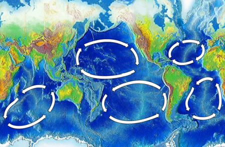
 The five major ocean gyres
A gyre in oceanography is any large system of rotating ocean currents, particularly those involved with large wind movements. Gyres are caused by the Coriolis Effect; planetary vorticity along with horizontal and vertical friction, which determine the circulation patterns from the wind curl (torque).[1] The term gyre can be used to refer to any type of vortex in the air or the sea, even one that is man-made, but it is most commonly used in oceanography to refer to the major ocean systems.
Contents
Major gyres
The following are the five most notable gyres:[2]
- Indian Ocean Gyre
- North Atlantic Gyre
- North Pacific Gyre
- South Atlantic Gyre
- South Pacific Gyre
Other gyres
Tropical gyres
 All of the world's larger gyres
Tropical gyres are less unified and tend to be mostly east-west with minor north-south extent.
- Atlantic Equatorial Current System (two counter-rotating circulations)
- Pacific Equatorial Current System
- Indian Monsoon Gyres (two counter-rotating circulations in northern Indian Ocean)[3]
Subtropical gyres
The center of a subtropical gyre is a high pressure zone. Circulation around the high pressure is clockwise in the northern hemisphere and counterclockwise in the southern hemisphere, due to the Coriolis effect. The high pressure in the center is due to the westerly winds on the northern side of the gyre and easterly trade winds on the southern side of the gyre. These cause frictional surface currents towards the latitude at the center of the gyre. The build-up of water in the center of the gyre creates equatorward flow in the upper 1,000 to 2,000 m (3,300 to 6,600 ft) of the ocean, through rather complex dynamics. This equatorward flow is returned poleward in an intensified western boundary current.
The intensified western boundary current of the North Atlantic Gyre is the Gulf Stream, in the North Pacific it's the Kuroshio Current, in the South Atlantic it's the Brazil Current, in the South Pacific it's the East Australian Current, and in the Indian Ocean it's the Agulhas Current.
Subpolar gyres
Subpolar gyres form at high latitudes (around 60°). Circulation of surface wind and ocean water is anticlockwise in the Northern Hemisphere, around a low-pressure area, such as the persistent Aleutian Low and the Icelandic Low. Surface currents generally move outward from the center of the system. This drives the Ekman transport, which creates an upwelling of nutrient-rich water from the lower depths.[4]
Subpolar circulation in the southern hemisphere is dominated by the Antarctic Circumpolar Current, due to the lack of large landmasses breaking up the Southern Ocean. There are minor gyres in the Weddell Sea and the Ross Sea, the Weddell Gyre and Ross Gyre, which circulate in a clockwise direction.[2]
See also
- Anticyclone
- Cyclone
- Ecosystem of the North Pacific Subtropical Gyre
- Eddy
- Fluid dynamics
- Great Pacific Garbage Patch
- Maelstrom
- North Atlantic Garbage Patch
- Skookumchuck
- Whirlpool
- Widening gyre
References
- ^ Heinemann, B. and the Open University (1998) Ocean circulation, Oxford University Press: Page 98
- ^ a b The five most notable gyres PowerPoint Presentation
- ^ Indian Monsoon Gyres
- ^ Wind Driven Surface Currents: Gyres
External links
- 5 Gyres - Understanding Plastic Marine Pollution
- Wind Driven Surface Currents: Gyres
- SIO 210: Introduction to Physical Oceanography - Global circulation
- SIO 210: Introduction to Physical Oceanography - Wind-forced circulation notes
- SIO 210: Introduction to Physical Oceanography - Lecture 6
- Physical Geography - Surface and Subsurface Ocean Currents
- North Pacific Gyre Oscillation — Georgia Institute of Technology
Ocean currents and gyres Currents - East Greenland
- Norwegian
- Transpolar Drift Stream
- Agulhas
- Angola
- Antilles
- Azores
- Baffin Island
- Benguela
- Brazil
- Canary
- Cape Horn
- Caribbean
- East Greenland
- East Iceland
- Falkland
- Florida
- Guinea
- Gulf Stream
- Irminger
- Labrador
- Lomonosov
- Loop
- North Atlantic
- North Brazil
- North Equatorial
- Norwegian
- Portugal
- Slope Jet
- South Atlantic
- South Equatorial
- Spitsbergen
- West Greenland
- Agulhas
- East Madagascar
- Equatorial Counter Current
- Indian Monsoon Current
- Indonesian Throughflow
- Leeuwin
- Madagascar
- Mozambique
- Somali
- South Australian
- South Equatorial
- West Australian
Gyres Major gyres- Indian Ocean Gyre
- North Atlantic Gyre
- South Atlantic Gyre
- North Pacific Gyre
- South Pacific Gyre
Other gyres- Beaufort Gyre
- Ross Gyre
- Weddell Gyre
Related Categories:


Wikimedia Foundation. 2010.