- Gilgit-Baltistan
-
Gilgit-Baltistan
گلگت - بلتستان
གིལྒིཏ་བལྟིསྟན— Administrative Unit — Gilgit-Baltistān Location of Gilgit-Baltistan (red), without Siachen Glacier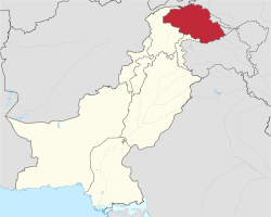
Coordinates: 35°21′N 75°54′E / 35.35°N 75.9°ECoordinates: 35°21′N 75°54′E / 35.35°N 75.9°E Country Pakistan Established 1 July 1970 Capital Gilgit Largest city Gilgit Government – Type Autonomous territory of Pakistan – Body Legislative Assembly – Governor Pir Karam Ali Shah[1] – Chief Minister Syed Mehdi Shah[2] Area – Total 72,496 km2 (27,990.9 sq mi) Population (2008; est.) – Total 1,800,000 – Density 24.8/km2 (64.3/sq mi) Time zone PKT (UTC+5) ISO 3166 code PK-NA Main Language(s) Assembly seats 33[3] Districts 7 Towns 7 Union Councils Website gilgitbaltistan.gov.pk Gilgit-Baltistan (Urdu: گلگت - بلتستان, Balti: གིལྒིཏ་བལྟིསྟན, formerly known as the Northern Areas (Urdu: شمالی علاقہ جات, Shumālī Ilāqe Jāt)),[4] is the northernmost political entity within Pakistan. It borders Pakistan's Khyber Pukhtunkhwa province to the west, Afghanistan's Wakhan Corridor to the north, China to the east and northeast, Azad Kashmir to the southwest, and Indian-administered Jammu and Kashmir to the southeast. Gilgit-Baltistan covers an area of 72,971 km² (28,174 mi²) and is highly mountainous. It has an estimated population approaching 1,000,000. Its administrative center is the city of Gilgit (population 216,760).
The territory became a single administrative unit in 1970 under the name Northern Areas and was formed by the amalgamation of the Gilgit Agency, the Baltistan District of the Ladakh Wazarat, and the states of Hunza and Nagar. Gilgit-Baltistan and the neighboring Azad Kashmir together constitute the distputed region, referred to as Pakistan-administered Kashmir by the United Nations[5] and other international organisations, and as Pakistan-occupied Kashmir in India.[6]
Contents
History
Main article: History of Gilgit-BaltistanFurther information: History of KashmirRock art and petroglyphs
There are more than 50,000 pieces of rock art (petroglyphs) and inscriptions all along the Karakoram Highway in Gilgit-Baltistan, concentrated at ten major sites between Hunza and Shatial. The carvings were left by various invaders, traders, and pilgrims who passed along the trade route, as well as by locals. The earliest date back to between 5000 and 1000 BCE, showing single animals, triangular men and hunting scenes in which the animals are larger than the hunters. These carvings were pecked into the rock with stone tools and are covered with a thick patina that proves their age. The ethnologist Karl Jettmar has pieced together the history of the area from various inscriptions and recorded his findings in Rock Carvings and Inscriptions in the Northern Areas of Pakistan[7] and the later released Between Gandhara and the Silk Roads - Rock Carvings Along the Karakoram Highway.[8] Many of these carvings and inscriptions will be inundated and/or destroyed when the planned Basha-Diamir dam is built and the Karakoram Highway widened.
Before the independence of Pakistan and the partition of India in 1947, Maharaja Hari Singh extended his rule to Gilgit and Baltistan. After the partition, Jammu and Kashmir, in its entirety, remained an independent state. The Pakistani parts of Kashmir to the north and west of the cease-fire line established at the end of the Indo-Pakistani War of 1947, or the Line of Control as it later came to be called, were divided into the Northern Areas (72,971 km²) in the north and the Pakistani state of Azad Kashmir (13,297 km²) in the south. The name "Northern Areas" was first used by the United Nations to refer to the northern areas of Kashmir. A small part of the Northern Areas, the Shaksgam tract, was provisionally ceded by Pakistan to the People's Republic of China in 1963.
Gilgit-Baltistan, which was most recently known as the Northern Areas, presently consists of seven districts, has a population approaching one million, has an area of approximately 28,000 square miles (73,000 km2), and shares borders with Pakistan, China, Afghanistan, and India. According to the Pakistani newspaper Daily Times, the people of Gilgit-Baltistan were liberated from the Dogra regime with the aid of the Pakistani army on 1 November 1947. The newspaper further states that while the area was independent for less than a month, they specifically requested the aid of the Pakistani government due to a lack of administrative infrastructure, and were thus incorporated into Pakistan upon the request of local residents.[9]
The local Northern Light Infantry is the army unit that was believed to have assisted and possibly participated in the 1999 Kargil conflict. More than 500 soldiers were believed to have been killed and buried in the Northern Areas in that action.[10] Lalak Jan, an Shia Imami Ismaili Muslim(Nizari) soldier from Yasin Valley, was awarded Pakistan's most prestigious medal, the Nishan-e-Haider, for his courageous actions during the Kargil conflict.
Autonomous status and present-day Gilgit-Baltistan
The main demand of the Gilgit-Baltistani people is to integrate their area into Pakistan and make it constitutionally a Pakistani province.[11][12] On 29 August 2009, the Gilgit-Baltistan Empowerment and Self-Governance Order, 2009, was passed by the Pakistani cabinet and later signed by the President of Pakistan. The order granted self-rule to the people of Gilgit-Baltistan, by creating, among other things, an elected legislative assembly. Gilgit-Baltistan thus gained de facto province-like status without having so constitutionally.[11][13] There has been criticism and opposition to this move in Pakistan, India, and Pakistan administrated Kashmir.[14]
On 29 September 2009, the Pakistani Prime Minister, while addressing a huge gathering in Gilgit-Baltistan, announced a multi-billion rupee development package aimed at the socio-economic uplifting of people in the area. Development projects will include the areas of education, health, agriculture, tourism and the basic needs of life.[15][16] The Prime Minister further went on to say:
"You are getting your identity today. It is your right and has been your demand, and today we are fulfilling it."[17]
Subdivisions
 Map of Gilgit-Baltistan, showing the boundaries of the six previous districts and their tehsils. The boundary between the recently created Hunza-Nagar District and the now smaller Gilgit District is the same line as the northern boundary of the former Gilgit Tehsil, which is the southernmost division of the area shown above in light blue. Sikanderabad, the administrative center of the new Hunza-Nagar District, is not yet shown on this map.
Gilgit-Baltistan is administratively divided into two divisions which, in turn, are divided into seven districts,[18] including the two Baltistan districts of Skardu and Ghanche, and the five Gilgit districts of Gilgit, Ghizer, Diamer, Astore, and Hunza-Nagar. The main political centres are the towns of Gilgit and Skardu.
Division District Area (km²) Population (1998) Headquarters Baltistan Ghanche 9,400 88,366 Khaplu Skardu 18,000 214,848 Skardu Gilgit Gilgit 39,300 383,324 Gilgit Diamir 10,936 131,925 Chilas Ghizar 9,635 120,218 Gahkuch Astore 8,657 71,666 Gorikot Hunza-Nagar Aliabad, Sikandarabad Gilgit-Baltistan totals 7 districts 72,971 970,347 Gilgit Geography and climate
Main article: Geography of Gilgit-Baltistan
Gilgit-Baltistan borders the Wakhan corridor of Afghanistan to the northwest, China's Uygur Autonomous Region of Xinjiang to the northeast, the Indian state of Jammu and Kashmir to the south and southeast, the Pakistani-controlled state of Azad Jammu and Kashmir to the south, and Pakistan's North-West Frontier Province to the west.
Gilgi-Baltistan is home to five of the "eight-thousanders" and to more than fifty peaks above 7000 meters. Gilgit and Skardu are the two main hubs for expeditions to those mountains. The region is home to some of the world's highest mountain ranges—the main ranges are the Karakoram and the western Himalayas. The Pamir mountains are to the north, and the Hindu Kush lies to the west. Amongst the highest mountains are K2 (Mount Godwin-Austen) and Nanga Parbat, the latter being one of the most feared mountains in the world.
Three of the world's longest glaciers outside the polar regions are found in Gilgit-Baltistan — the Biafo Glacier, the Baltoro Glacier, and the Batura Glacier. There are, in addition, several high-altitude lakes in Gilgit-Baltistan:
- Sheosar Lake in Deosai Plains - Astore region
- Satpara Tso Lake in Skardu - Baltistan
- Katzura Tso Lake in Skardu - Baltistan
- Zharba Tso Lake in Shigar - Baltistan
- Phoroq Tso Lake in Skardu - Baltistan
- Bara Tso Lake in Gangche - Baltistan
- Byarsa Tso Lake in Gultari - Baltistan
- Borith Lake in Gojal upper Hunza - Gilgit
- Rama Lake near Astore
- Rush Lake near Nagar - Gilgit
- Kromber Lake In Kromber Pass - Ishkoman Valley, Ghizer District
- Barodaroksh lake in Bar valley Nagar
The Deosai Plains, are located above the tree line, and constitute the second-highest plateau in the world at 4,115 meters (14,500 feet)after Tibet. The plateau lies east of Astore, south of Skardu and west of Ladakh. The area was declared as a national park in 1993. The Deosai Plains cover an area of almost 5,000 square kilometres. For over half the year (between September and May), Deosai is snow-bound and cut off from rest of Astore & Baltistan in winters. The village of Deosai lies close to Chilum chokki and is connected with the Kargil district of Ladakh through an all-weather road.
Climate
The climate of Gilgit-Baltistan varies from region to region, surrounding mountain ranges creates sharp variations in weather. The eastern part has the moist zone of the western Himalayas, but going toward Karakoram and Hindu Kush the climate dries considerably.[19]
There are towns like Gilgit and Chilas that are very hot during the day in summer, yet cold at night, and valleys like Astore, Khaplu, Yasin, Hunza, and Nagar where the temperatures are cold even in summer.
Economy and resources
The economy of region is basically based on traditional route of trade through Silk Road. China Trade organization was the leading economic forum through which most of barter trade activity made a phenomenal change in the general economical outlook of the area which being the remotest region of Pakistan was neglected for over quarter of century. This forum led the people of the area to actively invest and learn the modern trade know how from its neighbor Xingkiang. The participation of the all ethnic groups and active force behind this activity, legendary economist of the area Ashraf Khan brought a great change in the region. Later the establishment of Chamber of commerce and SOst dry port(in Gojal Hunza) are milestones. Rest of the economy is shouldered by mainly agriculture and tourism. Agriculture such as: wheat, corn (maize), barley, fruits; Tourism is mostly in trekking and mountaineering and this industry is 'growing in importance'[20][21]
In early September 2009, Pakistan signed an agreement with the People's Republic of China for a mega energy project in Gilgit-Baltistan which includes the construction of a 7,000-megawatt dam at Bunji in the Astore District.[22] This also resulted in protest from India, although Indian concerns were immediately rejected by Pakistan, which claimed that the Government of India has no locus standi in the matter.[23]
Sports
Polo is the favourite game of the people of Gilgit, Chilas, Astore, Hunza, Nagar and the surrounding areas.[citation needed] Every year, many tourists visit to enjoy polo in Gilgit-Baltistan.[citation needed] Other games such as cricket, Tuksori of Nagar, gulli danda, kabbadi, and volleyball are also played.[24]
Transport
Prior to 1978, Gilgit-Baltistan was cut off from Pakistan and rest of the world due to the harsh terrain and the lack of accessible roads. All of the roads to the south opened towards the Pakistani-controlled state of Azad Jammu and Kashmir (AKJ) and to the southeast towards the present-day Indian-controlled state of Jammu and Kashmir. During the summer, people could walk across the mountain passes to travel to Rawalpindi. The fastest way to travel, however, was by air, but air travel was accessible only to a few privileged local people and to Pakistani military and civilian officials. Then, with the assistance of the Chinese government, Pakistan began construction of the Karakoram Highway (KKH), which was completed in 1978. The Karakoram Highway (KKH) connects Islamabad to Gilgit and Skardu, which are the two major hubs for mountaineering expeditions in Gilgit-Baltistan. The journey from Rawalpindi/Islamabad to Gilgit takes approximately 20 to 24 hours. Landslides on the Karakoram Highway are very common. The KKH connects Gilgit to Tashkurgan and Kashgar in China via Sust (the customs and health inspection post on the Northern Areas side) and the Khunjerab Pass, the highest paved international border crossing in the world at 4,693 metres (15,397 feet).
Northern Areas Transport Corporation (NATCO) offers bus and jeep transport service to the two hubs and several other popular destinations, lakes, and glaciers in the area.
In March 2006, the respective governments announced that, commencing on June 1, 2006, a thrice-weekly bus service would begin across the boundary from Gilgit to Kashgar, China, and road widening work would begin on 600 kilometres of the Karakoram Highway. There would also be one daily bus in each direction between the Sust and Tashkurgan border areas of the two political entities.[25]
Pakistan International Airlines used to fly a Fokker F27 aircraft daily between Gilgit Airport and Islamabad International Airport. The flying time was approximately 50 minutes, and the flight was one of the most scenic in the world, as its route passed over Nanga Parbat, the peak of which mountain was higher than the aircraft's cruising altitude. However, the Fokker F27 aircraft was retired after a crash at Multan in 2006. Currently, flights are being operated by PIA to Gilgit on the brand-new ATR42-500 aircraft, which was purchased in 2006. With the new plane, cancellation of flights is much less frequent. PIA also offers regular flights of a Boeing 737 between Skardu and Islamabad. All flights, however, are subject to weather clearance, and, in winter, flights are often delayed by several days.
Demographics
The population consists of many diverse linguistic, ethnic, and religious groups, due in part to the many isolated valleys separated by some of the world's highest mountains. The population of this area is a mixture of many ethnic groups such as Shins, Yashkuns, Kashmiris, Kashgaris, Pathans,and Kohistanis. Ismailism is present here, unlike in the rest of Pakistan.[26] Urdu is the lingua franca of the region, understood by most of the inhabitants. The Shina language (with several dialects like Asturjaa, Kharuchaa, chilasi) is the language of 60% of the population, spoken mainly in Gilgit, Astore throughout Diamer, and in some parts of Ghizer. The Balti dialect, a sub-dialect of Ladakhi and part of the Tibetan languages group, is spoken by the entire population of Baltistan. Minor languages spoken in the region include Wakhi, spoken in upper Hunza, and in some villages in Ghizer, while Khowar is the language of Ghizer. Burushaski is an isolated language spoken in Hunza, Nagar, Yasin (where Khowar is also spoken), in some parts of Gilgit and in some villages of Punyal. Another interesting language is Domaaki, spoken by the musician clans in the region. A small minority of people also speak Pashto.
Despite being referred to as part of Kashmir, Gilgit-Baltistan has few remnants of Kashmiri. At the last census (1998), the population of Gilgit and Baltistan was 870,347.[27] Approximately 14% of the population was urban.[28]
See also
References
- ^ "Pir Karam Ali Shah appointed GB Governor". The News. 2011-01-26. http://www.thenews.com.pk/NewsDetail.aspx?ID=10133. Retrieved 2011-01-28.
- ^ "Associated Press Of Pakistan ( Pakistan's Premier NEWS Agency ) - Public service policy to be pursued in Gilgit-Baltistan: PM". Ftp.app.com.pk. http://ftp.app.com.pk/en_/index.php?option=com_content&task=view&id=92218&Itemid=1. Retrieved 2010-06-05.
- ^ Legislative Assembly will have directly elected 24 members, besides six women and three technocrats. "Gilgit Baltistan: New Pakistani Package or Governor Rule" 3 September 2009, The Unrepresented Nations and Peoples Organization (UNPO)
- ^ "Cabinet approves ‘Gilgit-Baltistan Empowerment and Self-Governance Order 2009’" 29 August 2009 Associated Press of Pakistan
- ^ http://ochaonline.un.org/humanitarianappeal/webpage.asp?Page=1893
- ^ http://www.sify.com/news/china-has-major-presence-in-pakistan-occupied-kashmir-gilgit-activist-news-international-kjcnubijjdc.html
- ^ "Rock Carvings and Inscriptions along the Karakorum Highway (Pakistan) - - a brief introduction". http://www.rzuser.uni-heidelberg.de/~u71/kara/intro.html.
- ^ "Between gandhara and the silk roads". http://www.rzuser.uni-heidelberg.de/~u71/kara/kat.html.
- ^ "Leading News Resource of Pakistan". Daily Times. http://dailytimes.com.pk/default.asp?page=2006\11\01\story_1-11-2006_pg7_28. Retrieved 2010-06-05.
- ^ [1] Special Report on Kargil", The Herald (Pakistan)
- ^ a b Indian Express: Gilgit-Baltistan: A question of autonomy
- ^ Pakistan's disputed Northern Areas go to polls
- ^ DAWN: Gilgit-Baltistan autonomy
- ^ "The Gilgit-Baltistan bungle". Thenews.jang.com.pk. 2009-09-10. http://thenews.jang.com.pk/print1.asp?id=197679. Retrieved 2010-06-05.[dead link]
- ^ Manzar Shigri (2009-11-12). "Pakistan's disputed Northern Areas go to polls". Reuters. http://www.reuters.com/article/idUSTRE5AB1ZE20091112. Retrieved 2010-06-05.
- ^ "Pakistani president signs Gilgit-Baltistan autonomy order _English_Xinhua". News.xinhuanet.com. 2009-09-07. http://news.xinhuanet.com/english/2009-09/07/content_12011387.htm. Retrieved 2010-06-05.
- ^ "Gilani announces development package for Gilgit Baltistan". GEO.tv. 2009-09-29. http://www.geo.tv/9-29-2009/49958.htm. Retrieved 2010-06-05.
- ^ "Wrangling over new Astore district headquarters". Dawn Newspaper Internet Edition. http://www.dawn.com/2005/08/01/nat13.htm. Retrieved 2006-11-17.
- ^ WWF Pakistan. "Climate of Gilgit-Baltistan (Northern Areas)". WWF Pakistan. http://www.wwfpak.org/nap/dnap_climatechange.php. Retrieved 2009-06-11.
- ^ Encyclopædia Britannica. "Baltistan (region, Northern Areas, Kashmir, Pakistan) - Britannica Online Encyclopedia". Britannica.com. http://www.britannica.com/EBchecked/topic/51055/Baltistan. Retrieved 2010-06-05.
- ^ Encyclopædia Britannica. "Gilgit (Kashmir region, Indian subcontinent) - Britannica Online Encyclopedia". Britannica.com. http://www.britannica.com/EBchecked/topic/233661/Gilgit. Retrieved 2010-06-05.
- ^ "Pakistan | Gilgit-Baltistan autonomy". Dawn.Com. 2009-09-09. http://www.dawn.com/wps/wcm/connect/dawn-content-library/dawn/news/pakistan/04-gilgit-baltistan-autonomy-qs-01. Retrieved 2010-06-05.[dead link]
- ^ [2][dead link]
- ^ Sports and games of the 18th and ... - Google Books. Books.google.co.nz. http://books.google.co.nz/books?id=XCl1c2yy5ooC&pg=PA25&dq=Sports+in+gilgit&as_brr=3&client=firefox-a&cd=5#v=onepage&q=Sports%20in%20gilgit&f=false. Retrieved 2010-06-05.
- ^ "Kashgar-Gilgit bus service planned". Dawn Newspaper Internet Edition. http://www.dawn.com/2006/03/23/nat2.htm. Retrieved 2006-11-17.
- ^ "Pakistan's Fragile Foundations". Council on Foreign Relations. 2009-03-12. http://www.cfr.org/publication/18749/.
- ^ "Administrative Divisions and Population of the Northern Areas (1998)". Northern Areas Management Information System. http://asp.isb.sdnpk.org/namis/census/NA%20Admin%20Division%20&%20Population.htm. Retrieved 2006-11-17.
- ^ "Population, poverty and environment" (PDF). Northern Areas Strategy for Sustainable Development. http://www.northernareas.org.pk/nassd/soed_pdf/ppe13.pdf. Retrieved 2006-11-17.
Further reading
- Pakistan Trekking Guide, by Isobel and Ben Shaw, 1993.
- Raman, A. D. (2004). "Of Rivers and Human Rights: the Northern Areas, Pakistan's Forgotten Colony in Jammu and Kashmir". International Journal on Minority and Group Rights 11: 187. doi:10.1163/1571811041631272.
External links
- Official Website of the Government of Gilgit Baltistan
- Gilgit-Baltistan at the Open Directory Project
- Northern Areas (Pakistan) travel guide from Wikitravel
- Pakistan, an external wiki

Badakhshan Province,  Afghanistan
Khyber Pakhtunkhwa 
 Xinjiang, China
 Gilgit-Baltistan

Azad Kashmir Disputed territory Provinces and administrative units of Pakistan Provinces 
Territories Kashmir Azad Kashmir · Gilgit-BaltistanSee also: Former administrative units of PakistanCategories:- Administrative units of Pakistan
- Gilgit-Baltistan
- Disputed territories in Asia
- Divided regions
- Foreign relations of Pakistan
- States and territories established in 1970


Wikimedia Foundation. 2010.