- Northam, Southampton
-
Coordinates: 50°54′45″N 1°23′28″W / 50.9124°N 1.391°W
Northam 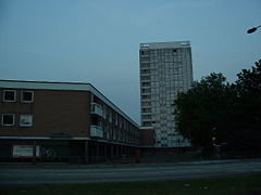
The Millbank Tower dominates the Northam skyline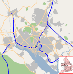
 Northam
Northam shown within SouthamptonUnitary authority Southampton Ceremonial county Hampshire Region South East Country England Sovereign state United Kingdom Post town SOUTHAMPTON Postcode district SO18 Dialling code 023 Police Hampshire Fire Hampshire Ambulance South Central EU Parliament South East England UK Parliament Southampton Itchen List of places: UK • England • Hampshire Northam is a suburb of Southampton in Hampshire. On the West bank of the River Itchen, it shares borders with St Mary's, Hampshire, Bitterne and Bevois Valley. Beside the border with St Mary's, Hampshire is the Chapel area, which has been home to some recent apartment building developments in Northam [1] [2]. The A3024 road runs through the suburb and crosses the Northam Bridge, which links Northam with Bitterne via Bitterne Manor. Although St Mary's Stadium takes its name from the neighbouring St Mary's, the stadium itself is in Northam, and home to Southampton F.C.. Northam has one of the highest crime rates in the South East of England.Violence against a person was at an all time high in 2009 with over 700 crimes being recorded.The area consists of blocks of flats, situated round Milbank tower a 20 story tower block.In 2010 a man walking through the estate was assualted by a local gang and was later found dead.[citation needed]
 The now derelict television studios
Northam also was home to an extensive television studio complex, run by ITV franchises Meridian Broadcasting, TVS and Southern Television, before Meridian moved their operations to Whiteley. The complex was demolished in 2009, leaving just a large, neat pile of rubble still extant throughout 2010. As well as the regional news magazine programme Meridian Tonight, the studios were originally home to the very first series of the popular game show, Catchphrase (before it moved to Maidstone Studios) and handled transmission of Meridian, Anglia and HTV West.
History
The Northam Railway Bridge was constructed in 1908 [3] and the first Northam Road Bridge was built in 1796 [4]. The original bridge was made of wood [5]. During Victorian times, much of Southampton's industry was based around the banks of the Itchen, and Northam was home to the Summers and Day iron works. Summers and Day launched the first iron ship to be built on the Itchen in 1842 [6].
Steamship companies (such as the White Star Line and the Cunard Line) were major employers in the district in the early 20th century. Over 350 Northam residents died aboard RMS Titanic when it foundered off the coast of Newfoundland in 1912; 125 students at one school alone were orphaned.[1]
In the early to mid 20th century the road bridge was rebuilt and strengthened, reopening in 1954 [7]. Around the same time and into the 1960s, much of the current Northam Estate was built to replace the slum conditions that had existed until that time [8].
In 1965, further work was undertaken on the A3024, the dual carriageway which runs through Northam, to coincide with the opening of the M27 motorway.
Aside from Millbank House, which forms part of the housing estate, one of the most dominant buildings in Northam is the Augustine Centre. The building was originally a Church of England church, and subsequently home to Northam Pentecostal Church. It was purchased by Riverside Family Church in the early 1980s and given its new name [9]. The building is a Grade II listed building.[2]
The London and South Western Railway opened a large Motive Power Depot at Northam in 1840, which remained the principal locomotive servicing facility in the area until 1903 when it was replaced by a new depot at Eastleigh. In 2001, South West Trains chose Northam as the location for the maintenance facility for their new Desiro fleet of trains, which replaced the last slam-door trains to run on the network. The Northam Traincare Facility was constructed by Turner & Townsend and opened in July 2003 by Brian Souter.
See also
- Northam railway station (England)
- St Mary's Stadium (with a Northam Stand)
External links and references
- ^ Titanic Voices by Donald Hyslop et al. Published by Southampton City Council, 1994.
- ^ Southampton City Council: Listed buildings in Southampton Accessed 13th September 2007.
Areas and Suburbs of Southampton City of Southampton Electoral Wards (and their neighbourhoods) listed by Constituency — sources: 1 2.Southampton Itchen Bargate Ward (City Centre, Ocean Village, The Polygon, St Mary's) • Bitterne Ward (Bitterne, Thornhill) • Bitterne Park Ward (Bitterne Park, Bitterne Manor, Midanbury, Townhill Park) • Harefield Ward (Harefield) • Peartree Ward (Peartree Green) • Sholing Ward (Sholing) • Woolston Ward (Woolston, Weston)Southampton Test Bevois Ward (Bevois Valley, Nicholstown, Northam) • Coxford Ward (Lordshill, Lordswood) • Freemantle Ward (Freemantle) • Millbrook Ward (Millbrook, Regents Park) • Portswood Ward (Portswood, Highfield, St Denys) • Redbridge Ward (Redbridge, Maybush) • Shirley Ward (Shirley, Southampton Common)Romsey and Southampton North Areas of Greater Southampton outside the City boundary include Chartwell Green, Chilworth, Nursling, Rownhams, Eastleigh, Totton, and West End.Categories:- Districts of Southampton
- Southampton


Wikimedia Foundation. 2010.