- Nuyts Archipelago
-
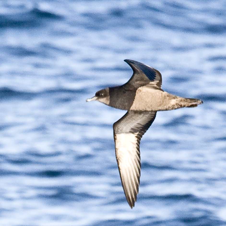
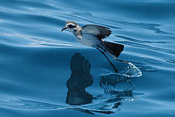 The archipelago is an important breeding site for White-faced Storm Petrels…
 …Short-tailed Shearwaters…
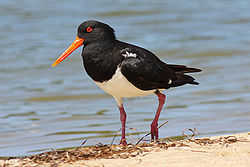 …and Pied Oystercatchers…
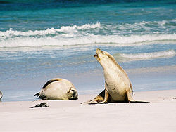 …as well as Australian Sea Lions
The Nuyts Archipelago, including the Isles of St Francis, comprises a group of mainly small and mostly granitic islands lying off Ceduna, South Australia, at the eastern end of the Great Australian Bight and the north-western coast of the Eyre Peninsula. Many of the islands support extensive colonies of Short-tailed Shearwaters, or muttonbirds, while its smaller islets and reefs provide breeding sites for Australian Sea Lions.
Contents
History
The archipelago was named in 1802 by Matthew Flinders after Dutch diplomat Pieter Nuyts, who was the senior official of the Dutch East India Company on the ship ′t Gulden Zeepaerdt ("The Golden Seahorse"), captained by François Thijssen who mapped the southern coastline of Australia from Albany to Ceduna in the course of a 1626–27 voyage from the Netherlands to Formosa and Japan. Nuyts was in the region of the archipelago in January 1627. Both Flinders and Nicolas Baudin, who also explored the area in 1802, named several of the islands.[1]
During the early 19th Century the archipelago and adjacent coast were used as a base for sealing and for whaling, usually by Hobart-based entrepreneurs who established whaling stations on St Peter Island as well as at Fowlers Bay and Streaky Bay.[2]
Description
Of the roughly 30 islands and reefs in the archipelago, those lying furthest from the coast of the Eyre Perninsula are known as the Isles of St Francis, after the largest. Most of the islands are formed of calcarenite lying on granite; where the softer calcarenite is close to sea level it has been heavily eroded by wave action. With the exception of Evans Island, the islands of the archipelago lie within either the Isles of St Francis or the Nuyts Archipelago Conservation Parks, both of which were constituted by statute in 1972 to conserve island populations and habitat for endangered species.[1]
The waters of the archipelago and the adjoining bays of the mainland are protected by the 4000 km2 Nuyts Archipelago Marine Park. The area is biologically unique in South Australia due to the influence of the Leeuwin Current, flowing eastwards across the Great Australian Bight and bringing features more typical of western than south-eastern Australia. In and around the archipelago the subtropical Leeuwin Current meets and mixes with the colder waters of the Flinders Current creating a biodiversity hotspot. Examples of the effect of the Leeuwin Current include the presence of plate corals and fish such as the Western Footballer.[3]
Islands
- Isles of St Francis Conservation Park
- St Francis Island – named in 1627 by Thijssen after his patron saint, at 809 ha it is the second largest island in the archipelago. It is covered by a mix of grassland, saltbush and low shrubland and supports a large population of muttonbirds (estimated at 273,000 pairs).[4] The highest point, 81 m above sea level, carries an automated lighthouse and radio beacon. It has a long history of agricultural use as well as of guano mining.[1]
- Masillon Island – lying 2.5 km south of St Francis, it was named in 1802 in the course of Baudin’s expedition after a Bishop of Clermont, Jean Baptiste Massillon.[1] It is vegetated with heathy shrubland and saltbush, and supports muttonbirds (39,520 pairs).[4]
- Fenelon Island – lying 1.5 km south of Masillon, it was named by Baudin after François Fénelon, a French archbishop and theologian.[1] It features heathland on shallow soils and supports a large population of White-faced Storm Petrels (13,000 pairs),[4] as well as a sea lion breeding colony.[5]
- Smooth Island – a dome-shaped island with a covering of dense, low scrub,[4] it lies 200 m north of St Francis.[1]
- Egg Island – lying 400 m north-east of St Francis, it is dome shaped with a high point 41 m above sea level.[1] It has deep soils and muttonbirds (400 pairs).[4]
- Dog Island – lying 300 m east-north-east of St Francis, it has saltbush shrubland and muttonbirds (1816 pairs).[4]
- Freeling Island – lying 100 m north-east of Dog Island, it was named after Major-General Sir Arthur Henry Freeling, Surveyor-General of South Australia.[1] It has muttonbirds (112 pairs).[4]
- West Island – lying in the open ocean 1.5 km west of St Francis, it features exposed granite surfaces[1] and is used by Cape Barren Geese.[4] It supports a sea lion breeding colony.[5]
- Lacy Island – lying 12 km north-east of St Francis, it was named by Flinders on 3 February 1802 after Mr Lacy, a crew member of HMS Investigator.[1] It has low heath, shrubland, and supports muttonbirds (4740 pairs).[4]
- Hart Island – the island was named after Captain John Hart, a Premier of South Australia.[1]
- Evans Island
- Evans Island – lying between the two conservation parks but part of neither, Evans is a lighthouse reserve managed by the Australian Commonwealth Government. It features Marsh Saltbush shrubland on deep soils, and supports muttonbirds (29,472 pairs).[4]
- Nuyts Archipelago Conservation Park
- St Peter Island (also called St Peter's Island) – at 13 km in length and 3429 ha in area, is the largest and most accessible island in the archipelago, and holds the greatest number of muttonbirds (334,800 pairs). It lies only 5 km from the mainland and was farmed from 1859 until it was added to the conservation park in 1988. Since sheep grazing ceased the vegetation has become dominated by regenerating native plant communities with patches of mallee woodland.[4] It was named in 1627 by Thijssen after Nuyts' patron saint.[1]
- Gliddon Reef – an islet to the south-west of St Peter, it supports a sea lion breeding colony.[5]
- Purdie Islands – little more than a chain of low rocks,[4] they were named by Flinders on 3 February 1802 after Robert Purdie, the surgeon’s assistant on the Investigator.[1] They support a sea lion breeding colony.[5]
- Lounds Island – covered by low, dense vegetation,[4] it was named by Flinders on 7 February 1802 after midshipman Sherrard Lound.[1] It supports a sea lion breeding colony.[5]
- Goat Island – a 303 ha island lying 2 km south-west of St Peter Island, it supports muttonbirds (94,800 pairs).[1]
- Breakwater Island – an islet to the south-east of Goat Island, it supports a sea lion breeding colony.[5]
- Eyre Island – a sand island supporting large numbers of Pied Oystercatchers,[4] it was named afte explorer Edward John Eyre.[1]
- Franklin Islands – both East and West Franklin Islands are covered by Nitre Bush on deep soils, with breeding muttonbirds (102,080 pairs).[4] They were named by Flinders on 3 February 1802 after midshipman John Franklin who was later to become well known as a polar explorer. Similar calcarenite-capped plateaus on granite platforms, the islands are joined at low tide by a strip of sand. Once part of the St Francis Island pastoral lease, they were occasionally used for grazing sheep. Public access to the Franklin Islands is prohibited in order to safeguard the relict population of stick-nest rats there.[1]
- Lilliput and Blefescu Islands – small islets which were only officially named in 2007, lying off East and West Franklin respectively, they both support sea lion breeding colonies.[5]
Important Bird Area
The archipelago, with the exception of Hart Island, has been identified by BirdLife International as a 110 km2 Important Bird Area (IBA) because it contains over 1% of the world populations of Short-tailed Shearwaters (with an estimated maximum of 890,740 breeding pairs), White-faced Storm-Petrels (22,750 breeding pairs) and Pied Oystercatchers (about 250 individuals).[6] Other birds nesting in the IBA include Little Penguins (over 1000 pairs), Pacific Gulls (about eight pairs), Caspian Terns (about 250 pairs) and Crested Terns (at least 3000 pairs), as well as Eastern Reef Egrets, Ospreys, White-bellied Sea Eagles and Hooded Plovers. Rock Parrots occur on Lounds Island and probably Smooth Island.[4]
Other animals
Tiger Snakes and Southern Carpet Pythons occur in the archipelago. Greater Stick-nest Rats are found on the Franklin Islands. An isolated subspecies of the Southern Brown Bandicoot (Isoodon obesulus nauticus) is endemic to the archipelago and confined to St Francis and the Franklin Islands. An unsuccessful attempt was made to reestablish a colony of Brush-tailed Bettongs on St Francis Island, where the species had previously become extinct; a similar introduction to St Peter Island has been more successful.[1][4] The archipelago is important for Australian Sea Lions; it contains eight breeding colonies as well as several haul-out sites.[5] Southern Fur Seals also use haul-out sites in the archipelago, while Southern Right Whales migrate along the coast from May to October.[7]
References
- ^ a b c d e f g h i j k l m n o p q r Anon (2006). Island Parks of Western Eyre Peninsula Management Plan. Adelaide: Department for Environment and Heritage, South Australia. ISBN 1 921238 18 6. http://www.environment.sa.gov.au/files/570dd7a4-2986-4563-ae90-9e4f00b22af4/WESTEYRE_IP.pdf.
- ^ O’Reilly, Rebecca. "St Peters Island". The Archaeology of Whaling in Southern Australia and New Zealand. Flinders University. http://ehlt.flinders.edu.au/archaeology/department/research/projects/awsanz/sStPeters.html.
- ^ "Nuyts Archipelago Marine Park". Marine Park 2. South Australian Government. http://www.environment.sa.gov.au/files/4bacd1f5-0745-4049-9b17-9e3600979ae4/MP_Park_Description_2.pdf. Retrieved 2011-09-10.
- ^ a b c d e f g h i j k l m n o p q BirdLife International. (2011). Important Bird Areas factsheet: Nuyts Archipelago. Downloaded from http://www.birdlife.org on 05/09/2011.
- ^ a b c d e f g h Goldsworthy, S.D.; Page, B.; Lowther, A.; Shaughnessy, P.D.; Peters, K.P.; Rogers, P.; McKenzie, J.; & Bradshaw, C.J.A. (2009). Developing population protocols to determine the abundance of Australian sea lions at key subpopulations in South Australia. SARDI Research Report No.348. Adelaide: Department of the Environment, Water, Heritage and the Arts, South Australia. http://www.sardi.sa.gov.au/__data/assets/pdf_file/0006/116268/No_348_Developing_population_protocols_AMMC_ASL_population_monitoring_2008.pdf.
- ^ "IBA: Nuyts Archipelago". Birdata. Birds Australia. http://www.birdata.com.au/iba.vm. Retrieved 2011-09-05.
- ^ Department of Environment and Natural Resources (2010), Environmental, Economic and Social Values of the Nuyts Archipelago Marine Park, Department of Environment and Natural Resources, South Australia.
Eyre Peninsula, South Australia Cities Townships Arno Bay · Baird Bay · Ceduna · Cleve · Coffin Bay · Cowell · Cummins · Darke Peak · Denial Bay · Elliston · Iron Knob · Kimba · Kyancutta · Lock · Minnipa · Poochera · Port Kenny · Port Neill · Pygery · Sceale Bay · Smoky Bay · Streaky Bay · Thevenard · Tumby Bay · Venus Bay · Wangary · Wirrulla · Wudinna · Yaninee · YeelannaNational parks Coffin Bay National Park · Gawler Ranges National Park · Lake Gilles Conservation Park · Lincoln National ParkIslands Councils Coordinates: 32°19′44″S 133°37′31″E / 32.32889°S 133.62528°E
Categories:- Important Bird Areas of Australia
- Islands of South Australia
- Eyre Peninsula
- Conservation parks of South Australia


Wikimedia Foundation. 2010.