- Ontario Highway 11
-
Highway 11

Route information Maintained by Ontario Ministry of Transportation Existed: 1920 (known as the Ferguson Highway prior) – present Major junctions West end:  MN 72 – Baudette, MN
 Highway 12 – Orillia
 Highway 60 – Huntsville
 Highway 17 – North Bay
 Highway 63 – North Bay
 Highway 64 – Marten River
 Highway 65 – New Liskeard
 Highway 66 – Kenogami
 Highway 101 – Matheson
 Highway 17 / Highway 61 – Thunder Bay
 Highway 71 – Fort Frances
South end:  Highway 400 – Barrie
Location Counties: Simcoe County, Muskoka Region, Parry Sound District, Timiskaming District, Cochrane District, Rainy River District Highway system Ontario provincial highways
400-series • Former←  Highway 10
Highway 12  →
→King's Highway 11 is a provincially maintained highway in the Canadian province of Ontario. At 1,780 kilometres (1,110 mi), it is the second longest highway in the province after Highway 17. Highway 11 begins at Highway 400 in Barrie, and arches through northern Ontario, around Lake Superior, to the Ontario–Minnesota border at Rainy River. The road continues as Minnesota State Highway 72 across the Baudette-Rainy River International Bridge. Highway 11 is unique in that it is signed as a north-south route for approximately half its length, and as an east-west route thereafter.
North and west of North Bay, Highway 11 forms part of the Trans-Canada Highway. The highway is also part of MOM's Way between Thunder Bay and Rainy River.
Contents
History
 1927 postcard of the Ferguson Highway
Highway 11 was originally planned as a trunk road to connect the communities of Southern Ontario to those of Northern Ontario, as a continuous route from Toronto to North Bay. In 1919, Premier of Ontario Ernest Charles Drury created the Department of Public Highways, though much of the responsibility for establishing the route, he left to Minister of the new cabinet position, Frank Campbell Biggs. Most of the route linked previously built roads such as Yonge Street, Penetanguishene Road, Middle Crossroad and the Muskoka Road, all early colonization roads in this region.
Further expansion was planned with a new highway from North Bay to Cochrane. Construction began in 1925, including reconstruction of portions of the old Muskoka Road from Severn Bridge which was officially opened on July 2, 1927. When it was opened, it was named the Ferguson Highway, in honour of Premier George Howard Ferguson (Drury's successor). Roads in northern Ontario later came under the Ministry of Transportation and became provincial highways.
 Highway 11 facing north towards Bracebridge
Over the years, Highway 11 grew to stretch from downtown Toronto all the way to the Minnesota border. Highway 11 became synonymous with Yonge Street, the name of the street in Toronto which formed its southernmost segment. It is from this that Yonge Street gained a disputed reputation as the "longest street in the world".
In 1997, the care of the highway portion south of Barrie, including Yonge Street, was transferred by the provincial government to various regional governments as part of significant cost reductions by the Ministry of Transportation of Ontario. This practice is called downloading, in that the financial burden will fall to a lower tier government, in the premise of reducing taxes. Along with the name Yonge Street, the section in York Region is now York Regional Road 1, the section in Simcoe County is now mostly Simcoe County 4. Within the city of Toronto, which does not have a regional road numbering system, it is now known simply as Yonge Street. Highway 11 consequently assumed the 1.1-kilometre highway stub formerly known as Highway 400A, and now ends at the interchange with Highway 400 just north of Barrie's city limits.
In 2003, a major bridge failure at the Sgt. Aubrey Cosens VC Memorial Bridge at the Montreal River in Latchford caused a complete closure and significant detour.
Major reconstruction of Highway 11 south of North Bay has taken place in recent years, upgrading the route from a two-lane rural highway to a four-lane road. In some sections the route is being built as an expressway with right-in/right-out ramps or at-grade intersections, while in others it is being built as a full 400-Series freeway. By the early-2010s, it is expected that all of the highway between Gravenhurst and North Bay will be four lanes. Despite the at-grade intersections, the normal freeway speed of 100 kilometres per hour (62 mph) is posted.
Highway 11 crosses the 45th parallel (halfway between the equator and north pole) 600 metres north of the bridge carrying Highway 118 at interchange 182, just outside of Bracebridge.
Due to a steep incline as it descends Thibeault Hill into North Bay, the southbound Algonquin Avenue segment of Highway 11 features the only runaway truck ramp on Ontario's highway system.[1] The Ministry of Transportation is currently undertaking a study of potential highway improvements in the North Bay area, which may include a new westerly realignment of this segment to bypass the hill.
Route description
Business routes
Highway 11B is the designation for business routes of Highway 11, nine of which have existed over the years. Two continue to exist today, while the remaining seven have been decommissioned. With the exception of the short spur route into Atikokan, all were at one time the primary route of Highway 11 through the communities they served, and were redesignated as 11B after a newer bypass alignment was constructed.
 Highway 11B entering Cobalt
All sections of Highway 11B have now been decommissioned by the province with the exception of the Atikokan route and the southernmost section of the former Tri-Town route between Cobalt and Highway 11.
In 1967, a section of the Cobalt route of Highway 11B collapsed into an abandoned mine, cutting off the town of Cobalt.[2]
- Holland Landing
- Orillia
- Gravenhurst
- Huntsville
- Powassan
- North Bay
- Cobalt/Temiskaming Shores
- Thunder Bay
- Atikokan
Future
 Highway 11 facing south from Highway 12 in Orillia
Highway 11 between Barrie and Gravenhurst is currently a rather unusual right-in/right-out (RIRO) expressway (local access permitted, turnarounds via special interchanges), except for a section around Orillia which is a full freeway. Another freeway section does exist in Barrie with the freeway segment from the southern terminus ending at Penetanguishene Road (Simcoe Road 93). The MTO is currently planning on either converting the existing RIRO expressway to a full six-lane freeway, or bypassing it with an entirely new alignment. An environmental and fiscal study concluded that the improvements from Barrie to Gravenhurst will involve the existing route being widened with the exception of a portion south of Gravenhurst that may potentially be constructed to the east of the current road.[3]
North of Gravenhurst to North Bay, the highway is a mixture of freeway sections and at-grade rural expressway (planned to be upgraded to a full freeway) except for one gap that remains a two-lane conventional highway; that section is expected to be widened by 2012.
Major intersections
Note the exit numbers start around 105 – currently the first posted exit number is 130 in Orillia – presumably for continuation from Highway 400.
Municipality Exit number Intersecting roads Springwater 104*  Highway 400
Crown Hill (Springwater – Oro-Medonte Boundary) 105* Penetanguishene Road (Simcoe County Road 93; former  )
)Oro-Medonte 109** Oro-Medonte Line 3 (Simcoe County Road 57)/"Gasoline Alley" Oro-Medonte 115** Oro-Medonte Line 7 (Simcoe County Road 127) Oro-Medonte 121** Oro-Medonte Line 11 (Simcoe County Road 20) Oro-Medonte – Orillia Boundary 129 Memorial Avenue (Simcoe County Road 49) (currently northbound only) Orillia 131  Highway 12 South / Old Barrie Road (Simcoe County Road 11)
Orillia 133 Highway 12 North / Coldwater RoadOrillia – Severn Boundary 135 Burnside Line/West Street (Simcoe County Road 18) Orillia – Severn Boundary 137* Laclie Street Severn 146** South Sparrow Lake Road (Simcoe County Road 38)/Goldstein Road Severn 151** Simcoe County Road 169 (formerly Ontario Highways  69 and 169)
Severn – Gravenhurst Boundary 153** Coopers Falls Road (Muskoka Road 6 and Simcoe County Road 52) Gravenhurst 154** Southwood Road (Muskoka Road 13) Gravenhurst 161** Kilworthy Road/Kahshe Lake Road Gravenhurst 169 Muskoka Road 169 (formerly Ontario Highways 69 and 169)Gravenhurst 175 Bethune Drive (Muskoka Road 41)/Doe Lake Road (Muskoka Road 6) Bracebridge 182 Highway 118/Muskoka Road 118 West Bracebridge 184 Cedar Lane (Muskoka Road 37) Bracebridge 189 Taylor Road (Muskoka Road 42) Bracebridge 191* Kirk Line (substandard) Bracebridge 193 Muskoka Road 117 (formerly Highway 117) Huntsville 205* South Mary Lake Road (Muskoka Road 44)/Stephenson Road 4 (at-grade intersection, interchange construction to begin soon) Huntsville 207  Highway 141/Port Sydney Road (Muskoka Road 10)
Huntsville 212* Allensville Road/Rowanwood Road (currently an at-grade intersection) Huntsville 216* Gryffin Lodge Road/Madill Church Road (currently an at-grade intersection) Huntsville 219 Muskoka Road 3 Huntsville 221 Muskoka Road 2 Huntsville 223  Highway 60
Huntsville 226 Muskoka Road 3/Old North Road Huntsville 231 North Waseosa Lake Road/Rockhaven Road (pictured below) Huntsville – Perry Boundary 235 Novar Road/ Highway 592 Perry 244 Fern Glen Road/Scotia Road Perry 248 Highway 518/Deer Lake Road Armour 252* Doe Lake Road/Three Mile Lake Road (at-grade intersection, interchange under construction) Armour 257* Highway 520/Ferguson Road (at-grade intersection, interchange under construction) Armour 261* Ontario Street (at-grade intersection, future interchange) Armour – Strong Boundary 266* Pevensey Road (at-grade intersection, future interchange) Strong 271* Black Creek Road/Robins Road (at-grade intersection, future interchange) Strong 276* Highway 124 (at-grade intersection, future interchange) Strong – Machar Boundary 284* Machar-Strong Boundary Road/Tower Road (future interchange) Machar 291* Highway 124 (Existing Highway 11) (interchange under construction) Parry Sound District (unincorporated) 294 Goreville Road/Summit Road Powassan 301 Highway 522/McFadden Line Powassan 306 Highway 522B/Hemlock Road Powassan 316 Highway 534/Clark Street Callander 329 Highway 654/Lake Nosbonsing Road North Bay 338 Lakeshore Drive North Bay 344  Highway 17
- *Exit number not signed, based on kilometre post
- **Current RIRO expressway section, possible interchange on new freeway
Images
-

Highway 11 just north of North Bay.
-

New 4-lane divided highway at North Waseosa Lake Road/Rockhaven Road interchange near Melissa.
-

Winter can pose serious driving hazards along Hwy 11 (near Temagami).
-

New 4-lane divided Hwy 11 (near Katrine).
References
- ^ "Northern Highways Program: 2010–2014. Ontario Ministry of Transportation.
- ^ Looker, Janet (2000). Disaster Canada. Lynx Images. p. 57. ISBN 1-894073-13-4.
- ^ [1]
External links
- Ontario Plaques – Ferguson Highway
- Ontario Highway 11 Homepage – A Virtual Community-by-Community Trip Along the World's Longest Street
- Highway 11 @ AsphaltPlanet.ca
 Portions of the Trans-Canada Highway
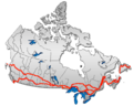 British Columbia: Highway 1 • Highway 5 • Highway 16 | Alberta: Highway 1 • Highway 16
Saskatchewan: Highway 1 • Highway 16 | Manitoba: Highway 1 • Highway 16 • Highway 100
Ontario: Highway 17 • Highway 69 • Highway 400 • Highway 12 • Highway 7 • Highway 71 • Highway 11 • Highway 66 • Highway 417
Quebec: Autoroute 40 • Autoroute 25 • Autoroute 20 • Autoroute 85 • Route 185 • Route 117 • Autoroute 15
New Brunswick: Route 2 • Route 16 | Confederation Bridge | Prince Edward Island: Route 1 | Nova Scotia: Highway 104 • Highway 105 • Highway 106
Newfoundland: Route 1The King's Highways of Ontario Current highwaysFormer highways- 2A
- 2B
- 2S
- 3B
- 4A
- 5A
- 7B
- 8A
- 12B
- 14
- 15A
- 18
- 18A
- 22
- 24A
- 25
- 27
- 29
- 30
- 31
- 32
- 35A
- 35B
- 36
- 38
- 39
- 40B
- 42
- 43
- 44
- 45
- 46
- 47
- 48B
- 50
- 51
- 52
- 53
- 54
- 55
- 56
- 57
- 59
- 68
- 70
- 73
- 74
- 75
- 76
- 78
- 79
- 80
- 81
- 82
- 83
- 84
- 86
- 87
- 88
- 90
- 91
- 92
- 95
- 96
- 97
- 98
- 99
- 100
- 103
- 104
- 106
- 107
- 109
- 110
- 111
- 114
- 116
- 117
- 119
- 120
- 121
- 122
- 123
- 126
- 128
- 131
- 133
- 134
- 135
- 136
- 169
- 400A
- 401A
County roads in Ontario · Ontario numbered highways · Expressways and 400-series highways · King's Highways · Secondary highways · Tertiary and 7000-series highways · List of Ontario provincial highways · List of former provincial highways in Ontario · Highways in Ontario · List of Ontario expressways · Trans-Canada Highway · Connecting Link · Emergency Detour RouteCategories:- Ontario provincial highways
- Trans-Canada Highway
- Proposed roads in Canada


Wikimedia Foundation. 2010.