- Ontario Highway 132
-
Highway 132
Route information Maintained by the Ministry of Transportation of Ontario Length: 30.3 km[2] (18.8 mi) Existed: January 11, 1956[1] – present Major junctions West end:  Highway 41 near Dacre
East end:  Highway 60 in Renfrew
Highway system Ontario provincial highways
400-series • Former←  Highway 130
Highway 136  →
→King's Highway 132, commonly referred to as Highway 132, is a provincially maintained highway the Canadian province of Ontario. Its western terminus is at Highway 41 near Dacre while its eastern terminus is at Highway 60 in Renfrew.
The length of Highway 132 is 30.3 km (18.8 mi). It is situated entirely in Renfrew County, travelling through the communities of Shamrock and Dacre. The road was built in the 1850s as part of the Opeongo and Ottawa Colonization Road, providing access to Renfrew County for settlement in the Opeongo Hills.
Contents
Route description
History
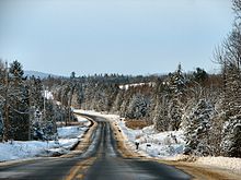 Highway 132 between Renfrew and Shamrock.
Highway 132 was assumed by the Department of Highways on January 11, 1956.[1] Prior to the designation of Highway 132, no other highways connected with Highway 17 between Pembroke, where it met Highway 62, and Arnprior, where it met Highway 29.[3] Although some minor realignments have occurred over the years, the route has more or less remained unchanged since its designation.[4]
Major intersections
 Highway 132 entering Renfrew
The following table lists the major junctions along Highway 132. In addition, it includes some minor junctions that are noted by the Ministry of Transportation of Ontario.[2] The entirety of Highway 132 is located within Renfrew County.[4]
Location km[2] Destinations Notes Renfrew 0.0 Highway 60 – DouglasAdmaston Bromley 5.7 County Road 5 (Stone Road) County Road 34 (Whelan Road) Dacre 27.7  Highway 513
Highway 513 may be decommissioned. It appears in Ministry documents but does not appear on any current maps, including the Official Ontario Road Map. Bonnechre Valley 30.3 Highway 41 – Denbigh, EganvilleReferences
- ^ a b Annual Report (Report). Department of Highways. March 31, 1956. p. 205.
- ^ a b c Ministry of Transportation of Ontario (2007). "Annual Average Daily Traffic (AADT) counts". http://www.raqsb.mto.gov.on.ca/techpubs/TrafficVolumes.nsf/tvweb?OpenForm&Seq=5. Retrieved June 9, 2011.
- ^ Ontario Department of Highways (1956). Ontario Road Map (Map). Cartography by C.P. Robins. Section O38–P40.
- ^ a b Peter Heiler (2010). Ontario Back Road Atlas (Map). Cartography by MapArt. p. 64, section P52–R55. ISBN 978-1-55198-226-7.
External links
The King's Highways of Ontario Current highwaysFormer highways- 2A
- 2B
- 2S
- 3B
- 4A
- 5A
- 7B
- 8A
- 12B
- 14
- 15A
- 18
- 18A
- 22
- 24A
- 25
- 27
- 29
- 30
- 31
- 32
- 35A
- 35B
- 36
- 38
- 39
- 40B
- 42
- 43
- 44
- 45
- 46
- 47
- 48B
- 50
- 51
- 52
- 53
- 54
- 55
- 56
- 57
- 59
- 68
- 70
- 73
- 74
- 75
- 76
- 78
- 79
- 80
- 81
- 82
- 83
- 84
- 86
- 87
- 88
- 90
- 91
- 92
- 95
- 96
- 97
- 98
- 99
- 100
- 103
- 104
- 106
- 107
- 109
- 110
- 111
- 114
- 116
- 117
- 119
- 120
- 121
- 122
- 123
- 126
- 128
- 131
- 133
- 134
- 135
- 136
- 169
- 400A
- 401A
County roads in Ontario · Ontario numbered highways · Expressways and 400-series highways · King's Highways · Secondary highways · Tertiary and 7000-series highways · List of Ontario provincial highways · List of former provincial highways in Ontario · Highways in Ontario · List of Ontario expressways · Trans-Canada Highway · Connecting Link · Emergency Detour RouteCategories:- Ontario provincial highways


Wikimedia Foundation. 2010.