- Ontario Highway 28
-
Highway 28
Route information Maintained by the Ministry of Transportation of Ontario Length: 162.6 km[1] (101.0 mi) Major junctions South end:  Highway 7 near Peterborough
East end:  Highway 41 at Denbigh
Highway system Ontario provincial highways
400-series • Former←  Highway 26
Highway 33  →
→King's Highway 28, commonly referred to as Highway 28, is a provincially maintained highway in the Canadian province of Ontario. The route travels in a southwest–northeast from Highway 7 east of Peterborough, to Highway 41 in Denbigh.
Contents
Route description
 Highway 28 north of its southern terminus at Highway 7
Highway 28 begins at an intersection with Highway 7 approximately 7 kilometres (4.3 mi) east of Peterborough. The road that carries Highway 28 continues south as Peterborough County Road 34 (Heritage Line). Proceeding north, Highway 28 crosses the Peterborough Drumlin Field, an area dominated by undulating terrain oriented in a southwest–northeast direction. Despite this, the highway progresses due north without regard for the terrain; numerous cuts and fills have since flattened the route for easier travel. Passing east of Lakefield, the straight path of the route is interrupted by the Otonabee River; it curves northeast and intersects Peterborough County Road 29 (Queen Street) and Road 6 while travelling south of the river. At Young's Point, the southern tip of Stony Lake, the highway crosses the river and serves cottages along the western shore of the lake. Approximately 1 kilometre (0.62 mi) south of Burleigh Falls, the route descends a hill and enters the Canadian Shield; south of this point, the terrain is underlain by limestone and covered by deciduous forests, whereas north of it the terrain is dominated by exposed granite bedrock and coniferous forests.[2]
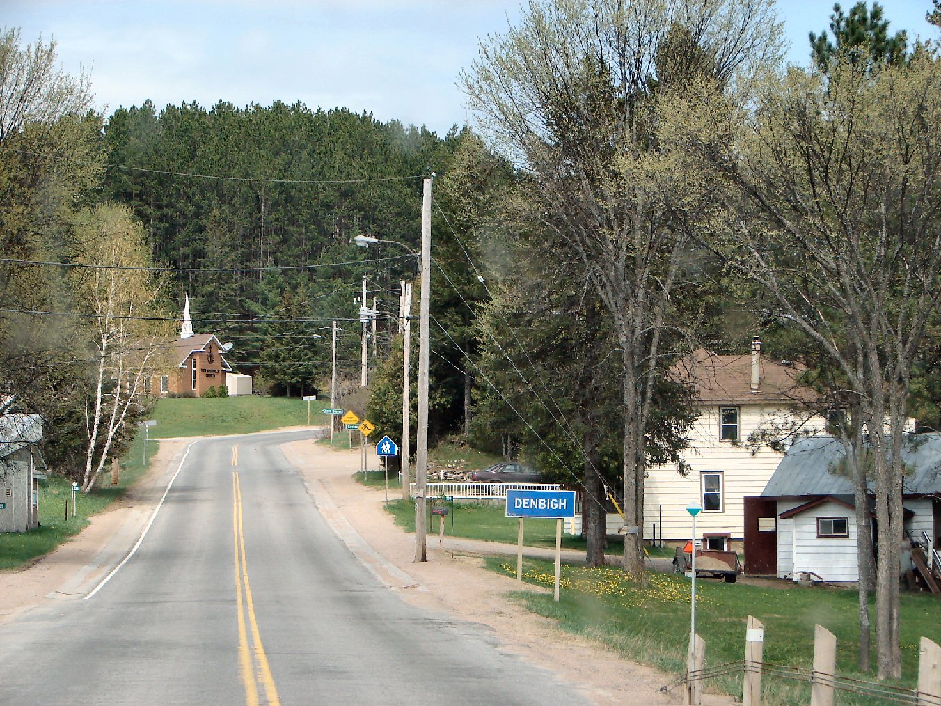
 The north-eastern end of Highway 28 in Denbigh
Within Burleigh Falls, Highway 28 encounters the eastern terminus of the former Highway 36. From there it continues northeast through the rugged shield to Highway 118, at which point it has curved fully to the east. The highway passes through Bancroft, where it encounters Highway 62. East of Bancroft, there is relatively little human inhabitation, with the exception of a select group of communities located on or nearby the highway. At the community of Denbigh, Highway 28 ends at a junction with Highway 41.[2]
History
Highway 28 was assigned in 1928, when the entirety of Highway 12A was renumbered. Highway 12A was one of the original provincial highways assumed in 1919 and 1920.[3] The Port Hope – Peterborough Road was assumed by the Department of Highways on August 11, 1920, extending from Highway 2 (Walton Street) in Port Hope to Highway 7 (George Street North) in downtown Peterborough.[4] The route received the 12A numbering during the summer of 1925.[5]
 Highway 28 east of McArthur Mills
During the mid-1930s, Highway 28 was extended as far north as Apsley. This was accomplished by assuming existing Peterborough County roads along the Otonabee River as far as Burleigh Falls, via Lakefield. North of there, the department assumed the Burleigh Falls Road. Highway 28 was extended from Peterborough to Burleigh Falls on April 4, 1934.[6] The Burleigh Falls Road was assumed to Apsley on August 11, 1937.[7]
During the 1936 fiscal year, preparations were made for the upcoming merger of the Department of Northern Development and Department of Highway, which occurred on April 1, 1937.[8] The town of Bancroft was chosen as the location of the first operations centre for the new Central District of the department. Consequently, it was decided to extend Highway 28 to the town along the remainder of the Burleigh Falls Road.[9]
In early 1956, Highway 500 was established between Kinmount and Hermon following the Monck Road.[10][11] In 1963, a new road was constructed between McArthur Mills and Denbigh through the Madawaska Highlands, and opened as an extension of Highway 500 on July 1.[12] During the early 1980s, Highway 500 was renumbered as an extension of Highway 28. This took place between 1980 and 1982.[13]
During the 1997 and 1998 mass downloading of highways, the southern 63 kilometres (39 mi) of Highway 28 were transferred to the counties of Peterborough and Northumberland, the town of Port Hope and Lakefield and the city of Peterborough. The section from Highway 115 north to Lakefield was decommissioned on April 1, 1997.[14] On January 1, 1998, the southernmost section, between Highway 2 and Highway 115, was transferred.[15] In 2003, the entirety of Highway 134 was redesignated as part of Highway 28, extending the southern terminus to Highway 7 east of Peterborough.[2]
Major intersections
The following table lists the major junctions along Highway 28, as noted by the Ministry of Transportation of Ontario.[1][2]
Division Location km[1][2] Destinations Notes Peterborough Otonabee – South Monaghan 0.0 Highway 7 – Peterborough, Ottawa, NorwoodFive Corners 6.2 County Road 4 – Warsaw Douro–Dummer 15.3 County Road 29 (Queen Street) – Lakefield End of former Highway 134 16.3 County Road 6 (Stony Lake Road) – Nephton Young's Point 21.1 County Road 20 (Young's Point Road) – Douro Burleigh Falls 31.0 County Road 36 – Buckhorn, Bobcaygeon Apsley 57.9 County Road 504 (Burleigh Road) – Lasswade 59.2 County Road 620A (Burleigh Road) Haliburton Dyno Estates 77.7 County Road 48 (Dyno Mines Road) – Cheddar Hastings Paudash 89.5  Highway 118 west – Haliburton, Bracebridge
Bancroft 99.6 Bancroft town limits; beginning of Connecting Link agreement  Highway 62 (Hastings Road) – Madoc, Maynooth
103.1 Bancroft town limits; end of Connecting Link agreement Carlow/Mayo 123.3 Bessemer Road – Hermon, Bessemer McArthur Mills 127.9 Little Mississippi River Bridge Renfrew Hardwood Lake 144.0 County Road 514 – Schutt Lennox and Addington Addington Highlands 162.6 Highway 41 – Pembroke, Kaladar, Eganville1.000 mi = 1.609 km; 1.000 km = 0.621 mi References
- Footnotes
- ^ a b Ministry of Transportation of Ontario (2007). "Annual Average Daily Traffic (AADT) counts". Government of Ontario. http://www.raqsb.mto.gov.on.ca/techpubs/TrafficVolumes.nsf/tvweb?OpenForm&Seq=5. Retrieved August 11, 2011.
- ^ a b c d Peter Heiler (2010). Ontario Back Road Atlas (Map). Cartography by MapArt. pp. 14, 20–21, 27, section H16–R20. ISBN 978-1-55198-226-7.
- ^ Shragge 1984, p. 74.
- ^ Annual Report (Report). Department of Highways. January 30, 1921. pp. 40, 43.
- ^ "Provincial Highways Now Being Numbered". The Canadian Engineer (Monetary Times Print) 49 (8): 246. August 25, 1925. "Numbering of the various provincial highways in Ontario has been commenced by the Department of Public Highways. Resident engineers are now receiving metal numbers to be placed on poles along the provincial highways. These numbers will also be placed on poles throughout cities, towns and villages, and motorists should then have no trouble in finding their way in and out of urban municipalities. Road designations from "2" to "17" have already been alloted..."
- ^ Annual Report (Report). Department of Highways. March 31, 1935. pp. 119.
- ^ Annual Report (Report). Department of Highways. March 31, 1938. pp. 81.
- ^ Shragge 1984, p. 71.
- ^ The Economic Base in Northern Hastings County. The Canadian Association of Geographers. p. 31. http://books.google.ca/books?ei=I1dqTvveHZXOM7XGja4F&client=firefox-a&cd=1&id=GhdJAQAAIAAJ&dq=%22Faulkner+Highway%22+Hastings&q=%22old+Hastings+road%22#search_anchor. Retrieved September 9, 2011.
- ^ Ontario Department of Highways (1956). Ontario Road Map (Map). Cartography by C.P. Robins. Section P35–Q37.
- ^ "Ontario Secondary Roads Now Designated 500, 600". 112. The Globe and Mail. February 4, 1956. p. 4. "Two new Ontario road numbers appear on the province's 1956 official road map which will be ready for distribution next week. The new numbers are the 500 and 600 series and designate hundreds of miles of secondary roads which are wholly maintained by the Highways Department. More than 100 secondary roads will have their own numbers and signs this year. All of these secondary roads were taken into the province's main highways system because they form important connecting links with the King's Highways"
- ^ A.A.D.T. Traffic Volumes 1955–1969 And Traffic Collision Data 1967–1969. Ontario Department of Highways. 1970. p. 118.
- ^ Ministry of Transportation and Communications (1980/81, 1982/83). Ontario Road Map (Map). Cartography by Photogrammetrey Office. Section D26–E27.
- ^ Highway Transfers List (Report). Ministry of Transportation of Ontario. April 1, 1997. p. 5.
- ^ Highway Transfers List - “Who Does What” (Report). Ministry of Transportation of Ontario. June 20, 2001. p. 10, 12.
- Bibliography
- Shragge, John; Bagnato, Sharon (1984). From Footpaths to Freeways. Ontario Ministry of Transportation and Communications, Historical Committee. ISBN 0-7743-9388-2.
External links
The King's Highways of Ontario Current highwaysFormer highways- 2A
- 2B
- 2S
- 3B
- 4A
- 5A
- 7B
- 8A
- 12B
- 14
- 15A
- 18
- 18A
- 22
- 24A
- 25
- 27
- 29
- 30
- 31
- 32
- 35A
- 35B
- 36
- 38
- 39
- 40B
- 42
- 43
- 44
- 45
- 46
- 47
- 48B
- 50
- 51
- 52
- 53
- 54
- 55
- 56
- 57
- 59
- 68
- 70
- 73
- 74
- 75
- 76
- 78
- 79
- 80
- 81
- 82
- 83
- 84
- 86
- 87
- 88
- 90
- 91
- 92
- 95
- 96
- 97
- 98
- 99
- 100
- 103
- 104
- 106
- 107
- 109
- 110
- 111
- 114
- 116
- 117
- 119
- 120
- 121
- 122
- 123
- 126
- 128
- 131
- 133
- 134
- 135
- 136
- 169
- 400A
- 401A
County roads in Ontario · Ontario numbered highways · Expressways and 400-series highways · King's Highways · Secondary highways · Tertiary and 7000-series highways · List of Ontario provincial highways · List of former provincial highways in Ontario · Highways in Ontario · List of Ontario expressways · Trans-Canada Highway · Connecting Link · Emergency Detour RouteCategories:- Ontario provincial highways


Wikimedia Foundation. 2010.