- Ontario Highway 2A
-
Highway 2A
Route information Maintained by City of Toronto Length: 3.4 km[1] (2.1 mi) Major junctions West end: Highland Creek overpass
(continues as Kingston Road)Lawson Road
Kingston Road
Port Union RoadEast end:  Highway 401 – Kingston
Highway system Ontario provincial highways
400-series • Former←  Highway 2
Highway 3  →
→King's Highway 2A, commonly referred to as Highway 2A, was the designation of five separate provincially maintained highways in the Canadian province of Ontario. Highway 2A was an alternate route to Highway 2 in London, Chatham and Cornwall; these routes were all eventually redesignated. Highway 2A was also a highway that extended from Windsor to Tilbury, which was redesignated as Highway 98 in 1938.
The final and most significant section of highway to be designated Highway 2A was the bypass of Highway 2 between Toronto and Newcastle, most of which became part of Highway 401 in July 1952. The short stub of dual carriageway connecting Kingston Road with Highway 401 was once again renumbered 2A in 1956 with the completion of the Toronto Bypass. Despite losing its provincial highway status in 1998, Highway 2A was never renamed and is now part of Toronto's municipal expressway system. The speed limit is 80 kilometres per hour (50 mph), and it is patrolled by the Toronto Police Service.
Contents
History
Toronto–Newcastle
As automobile use in southern Ontario grew in the early twentieth century, road design and construction advanced significantly. Following frequent erosion of the former macadamized Lake Shore Road,[2] a cement road known as the Toronto–Hamilton Highway was proposed in January 1914.[3] The highway was designed to run along the lake shore, instead of Dundas Street to the north, because the numerous hills encountered along Dundas would have increased costs without improving accessibility. Middle Road, a dirt lane named because of its position between the two, was not considered since Lake Shore and Dundas were both overcrowded and in need of serious repairs.[4] By November 1914, the proposal was approved,[5] and work began quickly to construct the road from Toronto to Hamilton known today as Lake Shore Boulevard and Lakeshore Road. The road was formally opened on November 24, 1917,[2] 18 feet (5.5 m) wide and nearly 40 mi (64 km) long. It was the first concrete road in Ontario, as well as one of the longest stretches of concrete road between two cities in the world.[6]
Over the next decade, vehicle usage increased substantially, and by 1920 Lakeshore Road was again highly congested on weekends.[7] In response, the Department of Highways examined improving another road between Toronto and Hamilton. Middle Road, a continuation of Queen Street west of the Humber River, was chosen to avoid delays on Dundas or Lakeshore. The road was to be more than twice the width of Lakeshore Road at 40 ft (12 m), and would carry two lanes of traffic in either direction.[8] Construction on what was then known as the Queen Street Extension between Highway 10 and Highway 27 began in early 1931,[9] and between Highway 27 and the Humber River on November 1, 1931.[10]
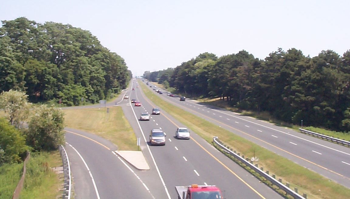
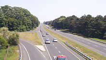 Aside from a resurfaced pavement and guardrails, Highway 2A has not been altered since it opened in 1947.
Before the highway could be completed, Thomas McQuesten was appointed the new minister of the Department of Highways, with Robert Melville Smith as deputy minister, following the 1934 provincial elections.[11] Smith, inspired by the German Autobahn's—new "dual-lane divided highways"—modified the design for Ontario roads,[12] and McQuesten ordered that the Middle Road be converted into this new form of highway.[13][14][15] A 132 ft (40 m) right-of-way was purchased along the Middle Road and construction began to convert the existing sections to a divided highway, as well as on Canada's first interchange at Highway 10.[8]
Beginning in 1935, McQuesten applied the concept of a dual-highway to several projects along Highway 2:[11] a 4 mi (6.4 km) stretch west of Brockville,[16][17] a 4.5 km (2.8 mi) stretch from Woodstock eastward,[16] and a section between Birchmount Road and east of Morningside Avenue in Scarborough Township.[17] When widening in Scarborough reached the Highland Creek ravine in 1936, east of Morningside, the Department of Highways began construction on a new bridge over the large valley, bypassing the former alignment around West Hill.[18] From here the highway was constructed on a new alignment to Oshawa, avoiding construction on the congested Highway 2.[19] As grading and bridge construction neared completion between Highland Creek and Ritson Road in September 1939, World War II broke out and gradually money was siphoned from highway construction to the war effort.[11]
They are designed for sustained speed, with the best alignments, fewest curves and least grades possible and by-passing centres of population.
“”Thomas McQueston[20]Following the war, construction resumed on roadways throughout Ontario. The expressway between Highland Creek and Oshawa was completed in December 1947.[19] The Toronto–Barrie Highway was the primary focus of the Department of Highways at the time, and the onset of the Korean War in 1949 continued to stall construction. Despite the delays, highway minister George Doucette officially announced the plans for construction of the new trans-provincial expressway in 1950, with the Toronto to Oshawa expressway serving as a model for the design.[11] Work on the most important link, the Toronto Bypass, began in 1951,[11] but it would not open with that name.
Along with an extension of the Highway between Oshawa and Highway 35 and Highway 115, most of Highway 2A was redesignated Highway 401 in July 1952.[19] A short stub between West Hill and the planned Toronto Bypass retained the Highway 2A designation until 1998, when it was transferred to the City of Toronto as part of a provincial downloading of highways to municipalities. Despite this, the highway has retained its name.[21]
Exit list
Street Notes Highway 401 Access from eastbound 401 and to westbound 401 using Kingston/Port Union Road interchange Port Union Road Modified Parclo A4 Kingston Road Westbound entrance; access from eastbound 401 via exit 390 Highland Creek Overpass Parclo A2 connecting to Old Kingston Road and Lawson Road
Additional RIRO lane on westbound side between the Parclo to the east and Highland Creek to the west, separated from main highway by a concrete median strip. The lane has an entrance from Old Kingston Rd westbound, and both entrances from and exits to Military Trail and Morrish RoadReferences
- Sources
- ^ Provincial Highways Distance Table. Ministry of Transportation of Ontario. 1989. p. 8. ISSN 0825-5350.
- ^ a b Emery pp. 179–182
- ^ "Toronto–Hamilton Highway Proposed". The Toronto World 34 (12125): p. 14. January 22, 1914. http://news.google.ca/newspapers?id=7jEBAAAAIBAJ&sjid=zSgDAAAAIBAJ&dq=toronto-hamilton%20highway&pg=6083%2C3025629. Retrieved February 9, 2010.
- ^ Shragge p. 55
- ^ "Council Meets Today To Pass Agreement". The Toronto World 34 (12402): p. 3. October 26, 1914. http://news.google.ca/newspapers?id=OCQBAAAAIBAJ&sjid=WSgDAAAAIBAJ&dq=toronto-hamilton%20highway&pg=2385%2C6925180. Retrieved February 9, 2010.
- ^ Shragge p. 55 "...the Toronto-to-Hamilton highway which, when completed in 1917, was both Ontario's first concrete highway and one of the longest such inter-city stretches in the world."
- ^ "Increased Volume of Traffic". Toronto World 40 (14472): p. 7. June 26, 1920. http://news.google.ca/newspapers?id=txE7AAAAIBAJ&sjid=jCoMAAAAIBAJ&dq=toronto%20hamilton%20highway%20traffic&pg=1299%2C13425430. Retrieved February 12, 2010.
- ^ a b Shragge pp. 79–81
- ^ Filey pp. 61–62
- ^ "Tenders Called For". The Gazette (Montreal) 160 (255): p. 15. October 16, 1931. http://news.google.ca/newspapers?id=R30uAAAAIBAJ&sjid=UYwFAAAAIBAJ&dq=toronto%20hamilton%20highway&pg=1922%2C2959605. Retrieved February 9, 2010.
- ^ a b c d e Shragge, John G. (2007). "Highway 401 – The story". Archived from the original on March 28, 2008. http://web.archive.org/web/20080328001341/http://www.roadscholar.on.ca/lateststory.html. Retrieved February 12, 2010.
- ^ Stamp pp. 19–20
- ^ "Hopes to Improve Roads". The Gazette (Montreal) 165 (42): p. 14. February 18, 1936. http://news.google.ca/newspapers?id=b74tAAAAIBAJ&sjid=xpgFAAAAIBAJ&dq=mcqueston%20highway&pg=3117%2C2124256. Retrieved February 9, 2010.
- ^ English, Bob (March 16, 2006). "Remember that 'little four-lane freeway?'". Globe And Mail (Toronto). http://www.theglobeandmail.com/auto/article159893.ece. Retrieved February 9, 2010. "...the freeway concept was promoted by Hamiltonian Thomas B. McQuesten, then the highway minister. The Queen Elizabeth Way was already under construction, but McQuesten changed it into a dual-lane divided highway, based on Germany's new autobahns."
- ^ Stamp pp. 11–12
- ^ a b Google, Inc. Google Maps – "Dual Highway" 2 east from Woodstock (Map). Cartography by Google, Inc. http://maps.google.com/maps?f=d&source=s_d&saddr=Dundas+St+E&daddr=43.142018,-80.672565&hl=en&geocode=FTwtkgId_TAw-w%3B&mra=dme&mrcr=0&mrsp=1&sz=15&sll=43.140922,-80.674582&sspn=0.013121,0.02738&ie=UTF8&ll=43.136819,-80.700245&spn=0.052486,0.10952&t=h&z=13. Retrieved March 8, 2010.
- ^ a b "Highway Conditions In Eastern Ontario". The Ottawa Citizen 94 (127): p. 29. November 13, 1936. http://news.google.ca/newspapers?id=jPAuAAAAIBAJ&sjid=z9sFAAAAIBAJ&dq=highway%20woodstock%20ontario&pg=5736%2C2815251. Retrieved February 16, 2010.
- ^ Brown p. 105
- ^ a b c Shragge pp. 93–94
- ^ "Ontario To Bar All Gas Stands On Speedways". The Gazette (Montreal) 167 (214): pp. 1, 19. September 7, 1938. http://news.google.ca/newspapers?id=k4kxAAAAIBAJ&sjid=bqgFAAAAIBAJ&dq=mcquesten%20minister&pg=6274%2C726272. Retrieved February 12, 2010.
- ^ MapArt 2010
- Bibliography
- Brown, Ron (1997). Toronto's Lost Villages. Polar Bear Press. ISBN 1-896757-02-2.
- Emery, Claire; Ford, Barbara (1967). From Pathway to Skyway. Confederation Centennial Committee of Burlington. pp. 179–182. http://www.ourroots.ca/e/page.aspx?id=946226. Retrieved May 3, 2010.
- Filey, Mike (1994). Toronto sketches 3: the way we were. Dundurn Press. pp. 61–62. ISBN 1-55002-227-X. http://books.google.ca/books?id=WCQKzZ6xW6sC&lpg=PA62&ots=CCJJJI8o_T&dq=%22Canada's%20First%20Superhighway%22&pg=PA61#v=onepage&q=%22Some%20Superhighway%20History%22&f=false. Retrieved February 10, 2010.
- Shragge, John; Bagnato, Sharon (1984). From Footpaths to Freeways. Ontario Ministry of Transportation and Communications, Historical Committee. ISBN 0-7743-9388-2.
- Stamp, Robert M. (1987). QEW – Canada's First Superhighway. The Boston Mills Press. ISBN 0-919783-84-8.
Major roads in Toronto North-south Bathurst · Bayview · Birchmount · Brimley · Browns Line · Dufferin · Islington · Jane · Keele · Kennedy · Kipling · Leslie · Markham · Martin Grove · McCowan · Morningside · Royal York · Victoria Park · Warden · Weston · Woodbine · YongeOther streetsAvenue/University · Bay · Black Creek · De Grassi · Jameson · Jarvis · John · Lansdowne · Mount Pleasant · Ossington · Palmerston · Parliament · Roncesvalles · Spadina · VaughanEast-west Concession roadsBloor/Danforth · Eglinton · Finch · Lawrence · Sheppard · St. Clair · Steeles · The Queensway/Queen West/Queen East · York MillsOther streetsCollege/Carlton · Dundas · Eastern · Front · Gerrard · King · Kingston · Lake Shore · Queen's Quay · RaymoreExpressways and highwaysThe King's Highways of Ontario Current highwaysFormer highways- 2A
- 2B
- 2S
- 3B
- 4A
- 5A
- 7B
- 8A
- 12B
- 14
- 15A
- 18
- 18A
- 22
- 24A
- 25
- 27
- 29
- 30
- 31
- 32
- 35A
- 35B
- 36
- 38
- 39
- 40B
- 42
- 43
- 44
- 45
- 46
- 47
- 48B
- 50
- 51
- 52
- 53
- 54
- 55
- 56
- 57
- 59
- 68
- 70
- 73
- 74
- 75
- 76
- 78
- 79
- 80
- 81
- 82
- 83
- 84
- 86
- 87
- 88
- 90
- 91
- 92
- 95
- 96
- 97
- 98
- 99
- 100
- 103
- 104
- 106
- 107
- 109
- 110
- 111
- 114
- 116
- 117
- 119
- 120
- 121
- 122
- 123
- 126
- 128
- 131
- 133
- 134
- 135
- 136
- 169
- 400A
- 401A
County roads in Ontario · Ontario numbered highways · Expressways and 400-series highways · King's Highways · Secondary highways · Tertiary and 7000-series highways · List of Ontario provincial highways · List of former provincial highways in Ontario · Highways in Ontario · List of Ontario expressways · Trans-Canada Highway · Connecting Link · Emergency Detour RouteCategories:- Toronto highways
- Defunct Ontario provincial highways

Wikimedia Foundation. 2010.