- Ontario Highway 35
-
Highway 35
Route information Existed: 1931 – present Major junctions South end:  Highway 401 – Newcastle
Highway 7A
 Highway 7 – Lindsay
 Highway 118 – Carnarvon
North end:  Highway 60 near Algonquin Park
Location Counties: Durham
Kawartha Lakes
Haliburton Highlands
MuskokaTowns: Newcastle, Orono, Lindsay, Coboconk, Minden, Carnarvon, Dorset, Dwight Highway system Ontario provincial highways
400-series • Former←  Highway 34
Highway 37  →
→King's Highway 35, also known as Highway 35, is a provincial highway in the Canadian province of Ontario, linking Highway 401 with Peterborough, Kawartha Lakes, and Algonquin Park. The highway travels from west of Newcastle, through Lindsay and the Kawarthas and into Haliburton before terminating at Highway 60 to the west of Algonquin Park, the province's largest. The winding course of the highway, combined with the picturesque views offered along its length, have led some to declare it the most scenic highway in Ontario.[1]
Most of the highway, including a portion of today's Highway 60, was assumed by the Department of Highways by 1940. In 1961, Highway 115 was signed concurrently with Highway 35 for 19 kilometres (12 mi). This was widened to a divided expressway in the late eighties. In the mid-1950s, several bypasses were constructed to divert Highway 35 away from town centres such as Lindsay, Fenelon Falls and Minden.
Highway 35 is patrolled along its entirety by the Ontario Provincial Police. The speed limit for most of the length of the highway is 80 kilometres per hour (50 mph), slowing to 50 km/h (31 mph) within built-up areas, and increasing to 90 kilometres per hour (56 mph) when it connects with Highway 115.
Contents
Route description
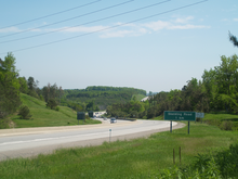 Highway 35 immediately south of of the split with Highway 115
Highway 35 begins at a trumpet interchange with Highway 401, and is concurrent with Highway 115 for 18.9 km (11.7 mi) to Enterprise Hill.[2][3][4] For the length of this concurrency, it is a divided four lane expressway with no left turns, known as right-in/right-out (RIRO). At Enterprise Hill, Highway 35 exits the divided highway (which continues as Highway 115 east to Peterborough) and proceeds north as a two lane road.[5] The highway crosses the Oak Ridges Moraine as it passes into the City of Kawartha Lakes.[6] The terrain flattens approaching Lindsay, which the highway bypasses.[2] Between Lindsay and Coboconk, the route is generally straight and crosses through a mix of agricultural lands and forest. After passing through Coboconk, it descends from the flat limestone plateau into the rocky Canadian Shield south of Norland.[6] The highway hugs the Gull River north of Norland and cuts through granite along its route into the Haliburton Highlands.[6][7] After passing Minden, the scenic highway begins diving into valleys and along cliffs overlooking several lakes.[8]
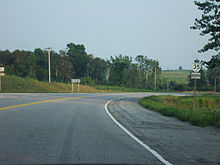 Highway 35 near Fenelon Falls
Highway 35 generally follows the former Bobcaygeon Colonization Road north of Minden, though several realignments over the years have led to its current winding route. At Carnarvon, it meets with Highway 118. [8] Heading northward into increasingly mountainous terrain, the highway crosses into Muskoka near Dorset, and shortly thereafter reaches its terminus at Highway 60 west of Algonquin Park.[7]
Traffic volumes on Highway 35 vary considerably over the length of the highway, as well as over the course of the year due to its use for recreational purposes, including snowmobiling, cottaging and camping. Along the Highway 35 and Highway 115 concurrency, the average daily vehicle count is above 20,000. This drops as Highway 35 splits off at Enterprise Hill to under 10,000. This volume is fairly consistent as far north as Minden, at which point the vehicle count drops below 5,000 and tapers off as low as 2,000 at Highway 60.[9]
History
 Highway 35 overlooking Cameron Lake in 1941
Highway 35, like many highways that begin at Lake Ontario and eventually cross into the Canadian Shield, began as several trails connecting settlements.[10] Most of the southern portion of the highway follows various sidelines and concessions.[7] Between Lindsay and Fenelon Falls, Highway 35 follows the former Fenelon Road, while north of there it follows The Cameron Road, a trail carved in the 1850s between Fenelon and Minden. North of Minden, the highway generally follows The Bobcaygeon Road, a colonization road built as far north as Dwight in the 1850s.[11]
The Highway 35 designation was first applied in 1931 to the road between Lindsay and Fenelon Falls. In 1934 it was extended along the road between Fenelon Falls and Rosedale,[12] bringing the length of the highway up to 38.9 km (24.2 mi). The Department of Northern Development had meanwhile spent the early 1930s upgrading the trails north of the Trent–Severn Canal that fell under their jurisdiction. A new road was constructed north of Dorset as part of the Ontario Northern Highways Program,[10] avoiding the straight Bobcaygeon Road.[11] The entire route from Rosedale to Huntsville became part of Highway 35 on April 1, 1937 when the Department of Northern Development merged into the Department of Highways,[10][13] adding an additional 138.4 km (86.0 mi) to the route. Finally in 1938, Highway 35 was extended south to Newcastle.[12]
 Highway 35 passes through several imposing rock cuts beginning north of Norland
At this point, much of the assumed route was a gravel road. Only the section south of Orono was paved. The Lindsay to Norland section was paved in the 1940s, and north of that point beginning in 1954. It would take until 1958 for paving to commence south of Lindsay.[12]
In 1953, Highway 115 was built as a two lane road eastward from Highway 35 near Pontypool.[12] It was completed to Peterborough by 1954,[14] and co-designated with Highway 35 southwards in 1961.[12][15] Construction began to widen both to four lanes beginning in 1984,[16] which was completed in the late 1980s and early 1990s.[17] The concurrency with Highway 60 was removed from Highway 35 after 1961,[18] but before 1969.[19]
Beginning in 1954, several bypasses were constructed around the towns and villages along the route.[12] The first of these was in Minden, bypassing the old route along the Bobcaygeon Road and South Water Street.[20] This was followed by the bypassing of Fenelon Falls in 1955. Highway 35 followed present day Kawartha Lakes Road 121 and Kawartha Lakes Road 8 into and out of the village until the Seventh Concession Line was paved and the highway rerouted onto it.[10][21] In 1956, Newcastle was bypassed and Highway 35 connected directly to the then eastern terminus of Highway 401 west of the village.[12] The former route is now Durham Regional Road 19.[7] By 1958, construction had begun on several bypasses of Lindsay,[22] including the Lindsay Bypass that Highway 7 and 35 follow today. Prior to the opening of the bypass, Highway 35 followed Lindsay Street to Kent Street and jogged northwest along William Street and Colborne Street. It then followed today's Kawartha Lakes Road 4 north and west to the current intersection with Highway 35. This routing became Highway 35B when the bypass opened in 1959.[12][23] In the 1960s, the route through Pontypool (now known as John Street) was bypassed.[12]
 Highway 35 north of Coboconk, showcasing the fall display. Shadow and Silver lakes are visible.
Prior to 2007, the highway was extensively rehabilitated between Kawartha Lakes Road 121, near Fenelon Falls and Highway 118 in Carnarvon. This included widening the highway for a third passing lane, as well as the resurfacing of several sections.[24]
Future
The MTO is currently performing an environmental assessment on Highway 35 between the Highway 115 split and Lindsay, in preparation for a four-lane expansion.[25][26] Work has also commenced on the widening of the Lindsay Bypass section of Highways 35 and 7 from two lanes to four.[27]
Major intersections
Division Location km[9] Destinations Notes Durham Region Newcastle 0.0 Highway 401 – Toronto, KingstonBeginning of divided highway; southern end of  Highway 115 concurrency
Lovekin Road No access across highway 1.3  Durham Regional Highway 2 (formerly
  Highway 2)
4.2 Clarke 3rd Concession 6.2 Clarke 4th Concession Orono 8.1  Regional Road 17 (Main Street) – Orono
Southbound exit and entrance; northbound exit, access to Main Street via Clarke 5th Concession 8.6 Station Street No access across highway 10.2 Mill Street Southbound exit and entrance Tamblyn Road Northbound exit and entrance Co-Op Road
Clarke 6th ConcessionSouthbound exit and entrance 9.9  Regional Road 4 (Taunton Road)
Clarke 6th ConcessionNo access from southbound 35/115 to Clarke 6th Concession; No access to southbound 35/115 Clarington 13.4  Regional Road 9 (Ganaraska Road) – Bewdley, Kirby
Clarke 7th ConcessionHighway 407 Future interchange[28] Clarke 8th Concession Skelding Road Southbound exit and entrance Beaucage Road Southbound entrance Wilcox Road Northbound exit and entrance Enterprise Hill 18.9 Highway 115 – PeterboroughNorthern end of Highway 115 concurrencyEnd of divided highway Durham 20.4  Regional Road 20 (Boundary Road)
Kawartha Lakes Pontypool 22.9  City Road 12 (Pontypool Road)
30.5 Highway 7A – Peterborough, Bethany Southern end of Highway 7A concurrency 32.0 Highway 7A – Port Perry Northern end of Highway 7A concurrency 39.1  City Road 57 (Golf Course Road) – Janetville
40.6  City Road 31 (Mount Horeb Road) – Omemee
Lindsay 50.0 Highway 7 East – Peterborough, Omemee /  City Road 15 North (Victoria Street)
Beginning of Highway 7 concurrency; City Road 15 formerly Highways 7B and 35B City Road 4 (Angeline Street South / Little Britain Road)
55.5 Highway 7 – TorontoEnd of Highway 7 concurrency; beginning of Highway 7B concurrency56.3 Highway 7B East (Kent Street West) / Uniroyal Road (South) End of Highway 7B concurrency; Highway 35 continues north; eastbound road continues as Highway 7B, formerly Highways 7B and 35B 59.5 City Road 4 (Thunder Bridge Road)62.9  City Road 21 (Killarney Bay Road)
Cameron 67.2  City Road 34 (Cameron Road)
72.4  City Road 121 (Victoria Road) – Fenelon Falls
Formerly Highway 121 76.6  City Road 8 (Victoria Road) – Fenelon Falls
Formerly Highway 35A 77.4 City Road 8 (Glenarm Road)Coboconk 92.5  City Road 43 (Somerville 7th Concession) – Burnt River, Four Mile Lake
92.9  City Road 42 (Baseline Road)
93.7  City Road 48 (Portage Road) – Beaverton
Formerly  Highway 48
Norland 101.4  City Road 45 (Monck Road) – Uphill, Kinmount
Formerly  Highway 503
Haliburton Highlands Minden Hills 111.8 County Road 2 (Deep Bay Road) Minden 126.0 County Road 121 – Kinmount Formerly Highway 121 128.7 County Road 16 (South Lake Road) – Gelert, Lochlin
County Road 2 (Newcastle Street)130.5 County Road 21 – Haliburton Village Formerly Highway 121 Carnarvon 143.6 Highway 118 – Bracebridge, Haliburton VillageHalls Lake 154.2 County Road 13 (Little Hawk Lake Road) Ox Narrows 160.4 County Road 11 (Kushog Lake Road) Dorset, Ontario 177.9 District Road 117 – Bracebridge Formerly Highway 117 County Road 39 (Main Street) County Road 8 (Kawagama Lake Road) Muskoka Lake of Bays District Road 21 (Fox Point Road) Dwight 195.6 Highway 60 – Huntsville, Whitney, Algonquin ParkReferences
- Sources
- ^ Cantor, George (September 29, 1974). "Nature's Palette Ablaze in Canada". The Los Angeles Times. p. 4. "Highway 35 which might be Ontario's most scenic road"
- ^ a b MapArt (2010). Southcentral Ontario (Map). ISBN 978-1-55368-221-9.
- ^ Government of Ontario (1990). Ontario Official Road Map (Map).
- ^ Rand McNally (2007). Toronto & area map book (Map). p. Page 4. ISBN 978-0-88640-928-9.
- ^ Google, Inc. Google Maps – Highway 35 / 115 junction (Map). Cartography by Google, Inc. http://maps.google.ca/?ie=UTF8&hq=&hnear=Toronto,+Toronto+Division,+Ontario&ll=44.061447,-78.62237&spn=0.003284,0.006899&t=k&z=17. Retrieved May 15, 2010.
- ^ a b c Trent Conservation Coalition (2004). Paleozoic Region - Bedrock Topography and Geology (Report). Ontario Ministry of Environment. http://www.ene.gov.on.ca/envision/water/groundwater/trent_river_watershed/precambrian/Map03-BedrockTopographyAndGeology.pdf. Retrieved December 26, 2009.
- ^ a b c d MapArt (2010). Ontario Back Road Atlas (Map). ISBN 978-1-55198-226-7.
- ^ a b "Haliburton County". CanPages. p. 38. http://www.myvirtualpaper.com/doc/Canpages_/HAL/2009050601/40.html. Retrieved May 15, 2010.
- ^ a b Ministry of Transportation of Ontario (2007). "Annual Average Daily Traffic (AADT) counts". http://www.raqsb.mto.gov.on.ca/techpubs/TrafficVolumes.nsf/tvweb?OpenForm&Seq=5. Retrieved June 26, 2011.
- ^ a b c d Suggitt pp. 66–67
- ^ a b Shragge p. 18
- ^ a b c d e f g h i Miller pp. 97–98
- ^ Shragge. p. 71
- ^ Canadian Press (March 1, 1955). ""Dishonest Practices" Hid Real Highway Work—Frost". 112. The Ottawa Citizen. p. 21. http://news.google.ca/newspapers?id=bIcwAAAAIBAJ&sjid=4dwFAAAAIBAJ&dq=ontario%20highway-35&pg=6551%2C1829426. Retrieved May 20, 2010.
- ^ Ontario Department of Highways (1961). Ontario Road Map (Map). Cartography by C.P. Robins. Section R35–S35.
- ^ Annual Report 1983–1984 (Report). Ontario Ministry of Transportation and Communications. March 31, 1984. http://books.google.com/books?ei=RrEjTNC4E4P7lweD7KyDAQ&ct=result&id=scA7AAAAMAAJ&dq=annual+report+Highway+403&q=Highway+403#search_anchor. Retrieved June 24, 2010.
- ^ Fulton, Ed (August 16, 1987). "Transport minister promises 4-lane Highway 115 by 1992". The Toronto Star. p. C.28. http://pqasb.pqarchiver.com/thestar/access/472964531.html?dids=472964531:472964531&FMT=ABS&FMTS=ABS:FT&type=current&date=Aug+24%2C+1987&author=Special+to+The+Star&pub=Toronto+Star&desc=Transport+minister+promises+4-lane+Highway+115+by+1992&pqatl=google. Retrieved May 20, 2010.
- ^ Ontario Department of Highways (1961). Ontario Road Map (Map). Cartography by C.P. Robins. Section P34.
- ^ Department of Highways p. 77–78
- ^ C. Tarling & Co (1951). County of Haliburton (Map). http://www.archives.gov.on.ca/english/on-line-exhibits/maps/counties/haliburton.aspx. Retrieved June 26, 2010.
- ^ C. Tarling & Co (1951). County of Victoria (Map). http://www.archives.gov.on.ca/english/on-line-exhibits/maps/counties/victoria.aspx. Retrieved June 26, 2010.
- ^ Ontario Department of Highways (1958). Ontario Road Map (Map). Cartography by C.P. Robins. Section Lindsay Inset.
- ^ Ontario Department of Highways (1960). Ontario Road Map (Map). Cartography by C.P. Robins. Section Lindsay Inset.
- ^ Ministry of Transportation of Ontario. Southern Highways Program 2007 to 2011 (Report). Government of Ontario. p. 50.
- ^ "Transportation & Logistics". City of Kawartha Lakes. http://www.city.kawarthalakes.on.ca/economic-development/site-selection/transportation-logistics/?searchterm=None. Retrieved May 3, 2010.
- ^ URS Consulting Canada. Highway 35 Planning Study Site (Report). Government of Ontario. Archived from the original on September 27, 2007. http://web.archive.org/web/20070929110210/http://highway35.planningstudy.on.ca/. Retrieved May 3, 2010.
- ^ Ministry of Transportation of Ontario. Southern Ontario Highways Program 2006 to 2010 (Report). Government of Ontario. p. 18. http://files.newswire.ca/6/routesud.pdf. Retrieved May 3, 2010.
- ^ 407 Study Team (2009). East Mainline Report (Report). Government of Ontario. http://www.407eastea.com/downloads/2009/East_Mainline_Part2.pdf. Retrieved September 8, 2010.
- Bibliography
- Miller, Ray Y C (2005). From Coal Oil Lights to Satellites. Trafford Publishing. ISBN 1-4120-4894-x. http://books.google.com/books?id=Tk6fG4rvd8UC&lpg=PA97&dq=Highway%2035%20Huntsville%20Ontario&pg=PA97#v=onepage&q=Highway%2035%20Huntsville%20Ontario&f=false. Retrieved June 25, 2010.
- Shragge, John; Bagnato, Sharon (1984). From Footpaths to Freeways. Ontario Ministry of Transportation and Communications, Historical Committee. ISBN 0-7743-9388-2.
- Suggitt, Gladys M. (1972). Roses and Thorns, A Goodly Heritage - The Early Days of Baddow and Area. John Deyell Co.
- AADT Traffic Volumes 1955–1969 And Traffic Collision Data 1967–1969. Department of Highways. 1969.
External links
- Highway 35 Planning Study official website (archived September 29, 2007)
- Map of the study area (archived September 29, 2007)
- Highway 35 at OntHighways.com
- Highway 35 and the issue of "Scope Creep"
The King's Highways of Ontario Current highwaysFormer highways- 2A
- 2B
- 2S
- 3B
- 4A
- 5A
- 7B
- 8A
- 12B
- 14
- 15A
- 18
- 18A
- 22
- 24A
- 25
- 27
- 29
- 30
- 31
- 32
- 35A
- 35B
- 36
- 38
- 39
- 40B
- 42
- 43
- 44
- 45
- 46
- 47
- 48B
- 50
- 51
- 52
- 53
- 54
- 55
- 56
- 57
- 59
- 68
- 70
- 73
- 74
- 75
- 76
- 78
- 79
- 80
- 81
- 82
- 83
- 84
- 86
- 87
- 88
- 90
- 91
- 92
- 95
- 96
- 97
- 98
- 99
- 100
- 103
- 104
- 106
- 107
- 109
- 110
- 111
- 114
- 116
- 117
- 119
- 120
- 121
- 122
- 123
- 126
- 128
- 131
- 133
- 134
- 135
- 136
- 169
- 400A
- 401A
County roads in Ontario · Ontario numbered highways · Expressways and 400-series highways · King's Highways · Secondary highways · Tertiary and 7000-series highways · List of Ontario provincial highways · List of former provincial highways in Ontario · Highways in Ontario · List of Ontario expressways · Trans-Canada Highway · Connecting Link · Emergency Detour RouteCategories:- Ontario provincial highways


Wikimedia Foundation. 2010.