- Ontario Highway 416
-
For the route in London, Ontario, see Veterans Memorial Parkway. For the route in Niagara Falls, see Ontario Highway 420.
Highway 416
Veterans Memorial Highway 
Route information Length: 76.4 km[1] (47.5 mi) History: Proposed 1966
Alignment built 1969–1983
Freeway built 1990–1999Major junctions South end:  Highway 401 – Prescott
North end:  Highway 417 – Ottawa
Highway system Ontario provincial highways
400-series • Former←  Highway 410
Highway 417  →
→King's Highway 416, commonly referred to as Highway 416 and as the Veterans Memorial Highway, is a 400-series highway in the Canadian province of Ontario which connects Highway 417 in Ottawa with Highway 401 between Brockville and Cornwall. It acts as an important trade corridor from Interstate 81 between New York and Eastern Ontario via 60 km (37 mi) of Highway 401, as well as the fastest link between Ottawa and Toronto. Highway 416 passes through a largely rural area, except near its northern terminus where it enters the suburbs of Ottawa. Despite this, the freeway bypasses several communities along its length, notably Spencerville and Kemptville.
Highway 416 was constructed by bypassing the original route of Highway 16, known as the Prescott Highway, along a new right-of-way. This two lane highway was constructed throughout the 1970s and completed in 1983, ending at the Prescott Highway (now Prince of Wales Drive) and featuring at-grade intersections. During the 1990s, this route was "twinned" with a second two lane road and interchanges constructed. A new freeway was also built along the route of Cedarview Road, connecting the northern end of the bypass with Highway 417. Sections of both opened throughout the late 1990s, with the final link being opened officially by a World War I veteran and local officials on September 23, 1999. The route was commemorated as the Veterans Memorial Highway on the 54th anniversary of D-Day.
Contents
Route description
Highway 416 is notable for several engineering innovations employed along its length. These concepts were largely the result of two factors: environment and cost. The route was constructed at the same time as Highway 407, which became a tolled highway, during a recession in the mid-1990s. For a time it was mentioned that Highway 416 would also be tolled, but ultimately this never happened. Instead, a hiatus in construction allowed engineers to evaluate inefficiencies in bridge and cross-section designs. Some of the unique design features include:
- Pre-tensioned concrete arch bridges, hollow inside, with support provided by cables running through the structure tensioned to over a million kilograms each.
- Blast furnace slag as base material over unstable leda clay within Ottawa. The slag weighs half that of normal aggregate.
- Sloped rock cuts to address collision severity with vertical rock faces.
- Groundwater retaining walls in the sunken section near Lynwood Village in Ottawa, preventing the lowering of the water table in wetlands adjacent to the route.
Route
 Highway 416 entering the western end of Ottawa. The Fallowfield Road interchange is shown.
Highway 416 is a 76.4-kilometre (47.5 mi) route connecting Highway 401 with Ottawa and Highway 417, the Trans-Canada Highway. It passes through a predominantly agricultural area for most of its length, servicing the towns of Spencerville, Kemptville, North Gower, and Manotick, all of which are situated near the route. North of Manotick, the route enters suburban Ottawa, and straddles the the community of Nepean and the Stony Swamp. While there are still segments of farmland throughout all but the northernmost part of this section, it is far more developed than the southern section.[2][3]
The freeway begins at an interchange with Highway 401, branching to the north near the community of Johnstown. This interchange only provides access to and from the west, but immediately north of it a second interchange with the remaining section of Highway 16 provides access from Johnstown and both directions of Highway 401.[2] Proceeding north, the two carriageways of the freeway are separated by an unconventional 68 m (223 ft) wide forested median.[4] The freeway is surrounded by thick forests and encounters almost no signs of human habitation for the following 10 km (6.2 mi). As it passes beneath the original route of Highway 16 - the Prescott Highway - south of Spencerville, it escapes the forest and enters farmland. The route travels to the east of the community, access to which is provided by an exit at County Road 21, enters a swamp and is crossed by the Prescott Highway again.[3] North of that crossing the two remain roughly parallel but separated as the freeway passes through a mix of farmland and forest. The Prescott Highway crosses the route a third time, this time at an interchange, south of the community of Kemptville.[2]
The freeway curves to the northeast, bypassing Kemptville and featuring an exit with former Highway 43.[3] It crosses the old Bytown and Prescott Railway,[5] then curves to the northwest, providing an exit to River Road before crossing the Rideau River and entering the Ottawa region.[2] Aside from the first couple kilometres north of the Rideau River, the majority of the freeway cuts through swaths of farmland which fill the Ottawa Valley. The median also narrows to a modest width for the remainder of the distance into Ottawa.[3] The route provides an interchange with Dilworth Road, then 2 km (1.2 mi) later with Roger Stevens Drive, the latter of which provides access to North Gower.[2]
Continuing through farmland, the freeway is crossed by the Prescott Highway for the fourth and final time as that road turns northeast and travels into downtown Ottawa as Prince of Wales Drive. An interchange is encountered shortly thereafter with Brophy Drive / Bankfield Road, the latter providing access to the Prescott Highway. Approaching urban Ottawa, the route passes alongside a large quarry, then abruptly jogs to the west, crossing the Jock River in the process.[2] After this an interchange with Fallowfield Road provides access to the suburb of Barrhaven, which occupies portions of the land immediately east of the freeway.[3] The route jogs to the east and passes through an aesthetically designed bridge alongside the Stony Swamp, which acts as a gateway to the National Capital Region. This structure is the longest rigid frame bridge in Ontario with a 59 m (194 ft) span, and was selected for the 1996 Award of Excellence from the Portland Cement Association.[6]
The final section of Highway 416 travels parallel to Cedarview Road, which was relocated for the freeway.[7] The Stony Swamp lies west of the route,[6] while farmland lies to the east.[3] At the northern end of the swamp is an interchange with West Hunt Club Road. The freeway continues through a section of greenspace before descending gently into a trench. It passes beneath Bruin Road and the Ottawa Central Railway while travelling alongside Lynwood Village. The highway is crossed by Baseline Road and Richmond Road, the former of which provides an onramp to southbound Highway 416. The freeway ends at a large interchange with Highway 417 (Exit 131) near the shore of Britannia Bay on the Ottawa River; downtown Ottawa is east and Kanata is west.[2]
History
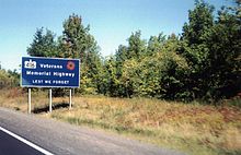 Highway 416 is commemorated as the Veterans Memorial Highway, not to be confused with the Veterans Memorial Highway in Halton Region or Niagara Veterans Memorial Highway in Niagara Falls
Highway 16 New
In 1966 the Eastern Ontario Highway Planning Study was published the Department of Highways (DHO), the predecessor to today's Ministry of Transportation of Ontario (MTO), identifying the need for a controlled-access highway between Ottawa and Highway 401.[8] Highway 16, which crosses the geologically subdued St. Lawrence Lowlands, was selected over Highway 15, which crosses the undulating Canadian Shield to the west, as the ideal route for the new link.[7] To overcome the issue of abutting properties established along the Highway 16 corridor, the DHO began purchasing a new right-of-way between Highway 401 and Century Road by late 1967, and constructed a two lane bypass of the original alignment, avoiding all the built up areas that the original Highway 16 encountered. This route was designed to easily accommodate the eventual upgrade to a freeway when traffic volumes necessitated.[9]
Construction of the Super two, dubbed Highway 16 New,[10] took place between 1969 and 1983.[8] The Spencerville Bypass opened by 1971, connecting with the old highway in the south near Crowder Road and in the north near Ventnor Road.[11] By the end of 1973 the new highway was completed from immediately north of Highway 401 through Leeds and Grenville United Counties and into Ottawa–Carleton. This included a bypass around Kemptville and a new structure over the Rideau River.[11] The new highway ended at Dilworth Road (Regional Road 13).
For nearly a decade, no new construction took place. Then, during the summer of 1982, the MTO awarded a contract to begin constructing the route north from Dilworth Road towards Manotick, bypassing North Gower. Following the completion of this first contract, which extended the route as far north as Roger Stevens Drive (Regional Road 6) and included a structure over Stevens Creek, a second contract was awarded for the remaining distance north to Century Road (Regional Road 8).[10] The project was completed in 1983,[8] merging into the original route of Highway 16 northeast of the present Prince of Wales Drive overpass.[12]
 Highway 416 approaching its terminus at Highway 417 in Ottawa
With the completion of Highway 16 New, the MTO need only construct interchanges and the southbound lanes in order to create a full freeway corridor. The upgrade to Highway 416 took place between 1989 and 1999 and was carried out through two separate projects: Highway 416 North was a 21 km (13 mi) freeway on a new alignment through Ottawa and an interchange at Highway 417, and Highway 416 South was the twinning of 57 km (35 mi) of Highway 16 New and an interchange at Highway 401.
Change of plans
The original plans for Highway 416, conceived during the late 1960s, had it enter Ottawa along the Merivale Corridor to merge with the Queensway approximately 5 km (3.1 mi) east of the present interchange. However, by the time this section was up for construction, public attitudes had shifted and environmental concerns had come to the forefront of everyday life; new roads were now subject to intense public scrutiny. Suburbs grew along Merivale Road, prompting the Regional of Ottawa–Carleton to request the MTO decommission the right-of-way along the road in 1977, which it did. The passing of the Environmental Assessment Act in 1975, however, meant that new projects were subject to a lengthy investigation of social and environmental concerns.[7][13]
In 1981, the Ministry began an Environmental Assessment into a new alignment for the northern connection with the Queensway.[13] The Environmental Assessment was approved in mid-1987, with Cedarview Drive chosen as the ideal alignment for the new freeway. The MTO set out to design a four lane route to connect the Queensway with Highway 16 New, including a three level free-flow interchange.[7] Construction of this interchange began in 1990 following the awarding of a contract in late 1989. During the 1991 construction season, contracts were awarded to construct several overpasses along the new route.[14] This contract was complete in 1993, after which budgetary restraints prevented the awarding of further contracts. As a result, aside from the interchange at Highway 417 and some overpasses, construction activity on Highway 416 came to a standstill for two years. During this period the MTO undertook an engineering review of the entire route, including structures, interchanges, alignment, construction techniques and cross-sections in search of cost inefficiencies. It was reported that C$7 million was saved as a result of this review, in addition to new freeway construction techniques.[8]
Twinning and completion
On December 8, 1995, in North Gower, the provincial and federal governments announced a financing deal to ensure Highway 416 South was completed by 2000.[15][16] This section of the route was constructed through a process known as twinning, in which a second carriageway is built parallel to an existing road and grade-separated interchanges constructed.[17] With the right-of-way along Highway 16 New already purchased, construction was able to proceed without disruption to local properties or traffic.
The 57 km (35 mi) project was constructed through five contracts. The first was awarded to Tarmac Canada on June 10, 1996, calling for twinning of 7.6 km (4.7 mi) from Century Road south to Roger Stevens Drive. Another contract was awarded one month later to Bot Construction, on August 19. This contract involved the section from Roger Stevens Drive south to Highway 43, a distance of 13 km (8.1 mi).[4] On June 12, 1997, the first section opened, connecting with the Ottawa Bypass at Century Road.[18] On July 10, the third contract was awarded to Armbro Construction to construct the 10 km (6.2 mi)section from Highway 43 south to Grenville County Road 20 (Oxford Station Road). Another contract followed on October 21 for the 12 km (7.5 mi) south to Grenville County Road 20 (Shanly Road), which was awarded to Bot Construction. The fifth and final contract was awarded to Armbro Construction on April 8, 1998, calling for the construction of the southern 9 km (5.6 mi) and two flyover ramps.[4]
The section between Roger Stevens Drive and Highway 43, including a second crossing of the Rideau River, opened to traffic on June 26, 1998.[19] This was followed two months later by the section between Highway 43 and Oxford Station Road, which opened on August 24.[20]
On the fifty-fourth anniversary of D-Day, June 6, 1998, Transportation Minister Tony Clement unveiled two signs in Ottawa and formally declared the entire length of Highway 416 as the Veterans Memorial Highway. Six additional signs were also installed along the length of the route.[21] On September 23, 1999, a ceremony was held in Johnstown to open the final section of Highway 416 that would complete the link from Highway 401 to Highway 417. Premier Mike Harris, Transportation Minister David Turnbell and World War I Veteran James W. Fraser officially opened the highway.[22]
On December 14, 2009, there was a 60-70 vehicle pileup due to fog and icy conditions, forcing the closure of the highway in both directions.[23]
Exit list
The following table lists the major junctions along Highway 416, as noted by the Ministry of Transportation of Ontario.[1]
Division Location km[1] Exit Destinations Notes Leeds and Grenville Johnstown 0.0 0 Highway 401 – Kingston, TorontoNo access from southbound 416 to eastbound 401; no access from westbound 401 to northbound 416; Exit 721A on eastbound 401 Edwardsburgh/Cardinal 3.1 1  Highway 16 south to American border
Services directions not accessible from previous interchange 13.4 12 County Road 21 – Spencerville North Grenville 25.8 24 County Road 20 (Oxford Station Road) 30.0 28 County Road 44 35.6 34 County Road 43 – Kemptville, Merrickville 41.6 40 County Road 19 (Rideau River Road) Rideau River Bridge Ottawa 43.8 42 Regional Road 13 (Dilworth Road) 50.3 49 Regional Road 6 (Roger Stevens Drive) – North Gower 58.8 57 Regional Road 8 (Bankfield Road/Brophy Road) – Manotick, Richmond 67.4 66 Regional Road 12 (Fallowfield Road) – Barrhaven 72.8 72 Regional Road 32 (West Hunt Club Road) 75.5 75C Holly Acres Road / Richmond Road (northbound only) 76.4 75A Highway 417 west (The Queensway)75B Highway 417 east (The Queensway)1.000 mi = 1.609 km; 1.000 km = 0.621 mi References
- ^ a b Ministry of Transportation of Ontario (2007). "Annual Average Daily Traffic (AADT) counts". Government of Ontario. http://www.raqsb.mto.gov.on.ca/techpubs/TrafficVolumes.nsf/tvweb?OpenForm&Seq=5. Retrieved September 26, 2011.
- ^ a b c d e f g Peter Heiler Ltd (2010). Ontario Back Road Atlas (Map). Cartography by MapArt. ISBN 978-1-55198-226-7.
- ^ a b c d e f Google, Inc. Google Maps – Highway 416 length and route (Map). Cartography by Google, Inc. http://g.co/maps/3ujz7. Retrieved October 26, 2011.
- ^ a b c Ministry of Transportation of Ontario (June 17, 2010). "Highway 416 South". Government of Ontario. http://www.mto.gov.on.ca/english/traveller/416/south.shtml. Retrieved October 26, 2011.
- ^ http://www.railways.incanada.net/Articles/Article2005_1.html
- ^ a b Ministry of Transportation of Ontario (June 17, 2010). "Highway 416 North". Government of Ontario. http://www.mto.gov.on.ca/english/traveller/416/north.shtml. Retrieved October 26, 2011.
- ^ a b c d Environmental Assessment Board (July 31, 1987). EA-86-01 (Report). Environmental Review Tribunal. p. 9. http://www.ert.gov.on.ca/files/DEC/ea8601d1.pdf. Retrieved September 30, 2011.
- ^ a b c d Ministry of Transportation of Ontario (June 17, 2010). "History of Highway 416". Government of Ontario. http://www.mto.gov.on.ca/english/traveller/416/history.shtml. Retrieved September 30, 2011.
- ^ "New 45-Mile Highway to Link Ottawa with 401". The Globe and Mail (Toronto) 124 (36,795): p. 4. November 14, 1967.
- ^ a b Ministry of Transportation and Communications (April 1982). Provincial Highways Construction Projects 1982–83 (Report). Transportation Capital Branch, Ministry of Transportation of Ontario. p. XXVII.
- ^ a b Ontario Department of Transportation and Communications (1971). Ontario Road Map (Map). Cartography by Photogrammetry Office. Section G–H30.
- ^ Google, Inc. Google Maps – Site of merger between Highway 16 and old Highway 16 before the construction of Highway 416 (Map). Cartography by Google, Inc. http://g.co/maps/aa75q. Retrieved September 30, 2011.
- ^ a b Ruck, Brian E; McCammon, Jeff C (1995). Environmental Approach to Urban Freeway Development (Report). Ministry of Transportation of Ontario. http://www.mto.gov.on.ca/english/traveller/416/brpaper.pdf. Retrieved October 4, 2011.
- ^ Transportation Capital Branch (May 1991). Northern Transportation Construction Projects 1988–89 (Report). Ministry of Transportation of Ontario. p. 16. ISSN 0714-1149.
- ^ [1]
- ^ [2]
- ^ "What is Involved in Constructing a Four Lane Highway?". Ministry of Transportation of Ontario. http://www.mto.gov.on.ca/english/traveller/highway69/construction.shtml. Retrieved October 12, 2011.
- ^ Ministry of Transportation of Ontario (June 12, 1997). "Transportation Minister Officially Opens Another 7.6 Kilometres of Highway 416". Government of Ontario. Archived from the original on May 20, 2001. http://web.archive.org/web/20010520171046/http://www.mto.gov.on.ca/english/traveller/416/june12.htm. Retrieved October 26, 2011.
- ^ Ministry of Transportation of Ontario (June 26, 1998). "New Section of Veterans Memorial Highway Opened Today". Government of Ontario. Archived from the original on March 5, 2000. http://web.archive.org/web/20000305080025/http://www.newswire.ca/government/ontario/english/releases/June1998/26/c6908.html. Retrieved October 26, 2011.
- ^ Ministry of Transportation of Ontario (August 24, 1998). "New Section of Veterans Memorial Highway Opened Today". Government of Ontario. Archived from the original on November 10, 1999. http://web.archive.org/web/19991110063704/http://www.newswire.ca/government/ontario/english/releases/August1998/24/c4455.html. Retrieved October 26, 2011.
- ^ "D-Day Anniversary Marked With Naming of Veterans Memorial Highway". Ottawa: Canadian NewsWire. Archived from the original on November 4, 1999. http://web.archive.org/web/19991104111852/http://www.newswire.ca/government/ontario/english/releases/June1998/06/c1558.html. Retrieved October 13, 2011.
- ^ Canadian Press (September 24, 1999). "Ottawa Highway Link Opens". Toronto Star: p. A4.
- ^ "Fog, Ice Blamed for Huge Ottawa Highway Pileup". CBC News. December 14, 2009. http://www.cbc.ca/canada/montreal/story/2009/12/14/ottawa-highway-416-closed.html. Retrieved October 13, 2011.
External links
Controlled-access highways of Ontario 400-series highways Other highways Current: 2A · 11 · 58 · 115 · 137 · Conestoga Pkwy. · Dougall Pkwy. · E.C. Row Expwy. · Hanlon Pkwy. · Queensway · Thunder Bay Expwy.
Municipal: Black Creek Dr. · Burlington St. · Cootes Dr. · Don Valley Pkwy. · Gardiner Expwy. · Harbour Expwy. · Highbury Ave. · Lincoln M. Alexander Pkwy. · Queensway · Red Hill Valley Pkwy. · Vets Mem. Pkwy. · W.R. Allen Rd.
Proposed: GTA West Corridor · Halton–Peel Freeway · Mid-Peninsula Highway · Bradford Bypass · West Durham Link · East Durham LinkCounty roads in Ontario · Ontario numbered highways · Expressways and 400-series highways · King's Highways · Secondary highways · Tertiary and 7000-series highways · List of Ontario provincial highways · List of former provincial highways in Ontario · Highways in Ontario · List of Ontario expressways · Trans-Canada Highway · Connecting Link · Emergency Detour RouteRoads in Ottawa Provincial Highways Major Arteries 4th Line · Tenth Line · Airport · Albion · Bank · Baseline · Blair · Bronson · Carling · Carp · Cedarview · Conroy · Donnelly · Dwyer Hill · Eagleson · Elgin · Fallowfield · Greenbank · Hazeldean · Heron · Hunt Club · Innes · King Edward · March · Merivale · Mitch Owens · Moodie · Montreal · Parkdale · Prince of Wales · Regional Road 174 · Richmond · Rideau · River · Riverside · Robertson · St. Joseph · St. Laurent · Strandherd · Terry Fox · Vanier · Walkley · Wellington · WoodroffeCollectors/Secondary Arteries Albert · Alta Vista · Bankfield · Beechwood · Booth · Brookfield · Gladstone · Hawthorne · Hog's Back · Jockvale · Katimavik · Kent · Laurier · Lees · Leitrim · Main · Maitland · Meadowlands · Metcalfe · Nicholas · North Gower · O'Connor · Old Prescott · Osgoode Main · Pinecrest · Preston · Russell · Slater · Smyth · Somerset · Sparks · St. Patrick · Sussex · Tremblay · TrimFederal arteries Categories:- 400-series highways in Ontario


Wikimedia Foundation. 2010.