- Iwo Jima
-
For other uses, see Iwo Jima (disambiguation).
Iwo Jima Native name: 硫黄島 
Location of Iwo Jima in the Pacific OceanGeography Location Pacific Ocean Coordinates 24°47′N 141°19′E / 24.783°N 141.317°E Archipelago Volcano Islands Area 8 sq mi (21 km2) Highest elevation 161 m (528 ft) Highest point Mount Suribachi[1] Country Subprefecture Ogasawara Subprefecture Demographics Population No native population (military personnel only) Iwo Jima, officially Iōtō (硫黄島, [2]
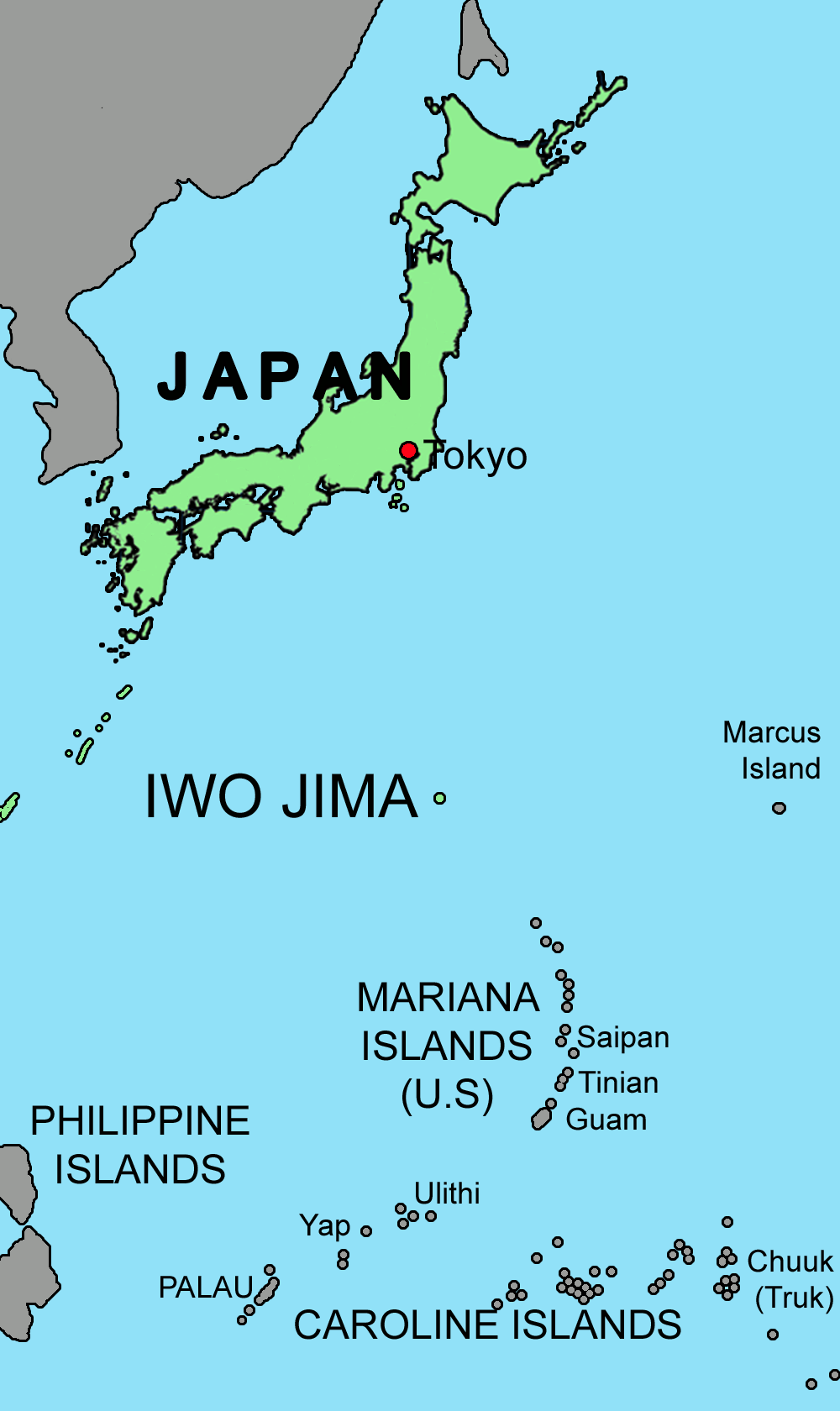
 listen (help·info): "sulfur island"), is an island of the Japanese Volcano Islands chain, which lie south of the Ogasawara Islands and together with them form the Ogasawara Archipelago. The island is located 650 nautical miles (750 mi; 1,200 km) south of mainland Tokyo and administered as part of Ogasawara, one of eight villages of Tokyo (but is presently uninhabited). It is famous as the setting of the February–March 1945 Battle of Iwo Jima between the United States and the Empire of Japan during World War II. The island grew in recognition in the west when the iconic photograph Raising the Flag on Iwo Jima was taken during the battle. The U.S. occupied Iwo Jima until 1968, when it was returned to Japan.
Contents
Name
In 1779, the island was charted as Sulphur Island, the literal translation of its official name, during Captain James Cook's third surveying voyage.[3]
The historical spelling iwautau[4] had come to be pronounced (approximately) Iwōtō by the age of Western exploration, and the 1946 orthography reform fixed the spelling and pronunciation at Iōtō. An alternative, Iwōjima, modern Iōjima, also appeared in nautical atlases.[5] Tō and shima are different readings of the kanji for island (島), the shima is changed to jima in this case. Japanese naval officers who arrived to fortify the island before the U.S. invasion mistakenly called it Iwo Jima.[5] In this way, the "Iwo Jima" reading became mainstream and was the one used by U.S. forces who arrived during World War II. Former island residents protested against this rendering, and the Ministry of Land, Infrastructure and Transport's Geographical Survey Institute debated the issue and formally announced on June 18, 2007, that the official Japanese pronunciation of the island's name would be reverted to the pre-war Iōtō.[2] Moves to revert the pronunciation were sparked by the high profile films Flags of Our Fathers and Letters from Iwo Jima.[5] The change does not affect how the name is written with kanji, "硫黄島", only how it is pronounced or written in hiragana, katakana and rōmaji.
Geographic features
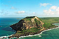
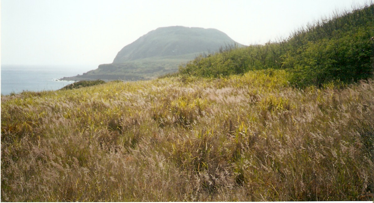
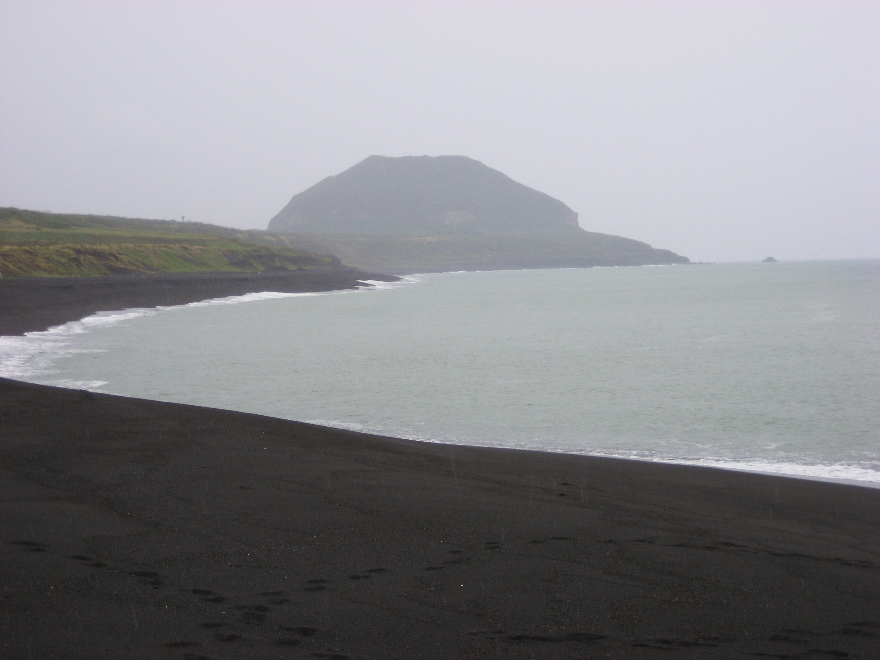
The island has an approximate area of 21 square kilometres (8 sq mi). The most prominent feature is Mount Suribachi[6] on the southern tip, a vent that is thought to be dormant and is 161 metres (528 ft) high.[1] Named after a Japanese grinding bowl, the summit of Mount Suribachi is the highest point on the island. Iwo Jima is unusually flat and featureless for a volcanic island. Suribachi is the only obvious volcanic feature, as it is only the resurgent dome (raised centre) of a larger submerged volcanic caldera.[7]
Captain Cook's surveying crew in 1776 to 1779 landed on a beach which is now 40 metres (131 ft) above sea level due to volcanic uplifting.[7] Such uplifting occurs on the island at a varying rate of between 100 and 800 millimetres (3.9 and 31 in) per year, with an average rate of 200 millimetres (8 in) per year.[8]
Forty-three nautical miles (50 mi, 80 km) north of the island is North Iwo Jima (北硫黄島 Kitaiōtō, literally: "North Sulfur Island") and 32 nautical miles (37 mi; 59 km) south lies South Iwo Jima (南硫黄島 Minamiiōtō, "South Sulfur Island"), with the three islands making up the Volcano Islands group of the Ogasawara Islands. Just south of Minamiiōjima are the Mariana Islands.
Iwo Jima has a history of minor volcanic activity a few times per year[9] (fumaroles, discolored patches of seawater nearby), but so far no sign of a big eruption coming.
Climate data for Iwo Jima Month Jan Feb Mar Apr May Jun Jul Aug Sep Oct Nov Dec Year Average high °C (°F) 22
(71)22
(71)23
(73)26
(78)28
(82)29
(85)30
(86)30
(86)30
(86)29
(84)27
(80)24
(75){{{year high C}}}
(80)Average low °C (°F) 17
(63)17
(63)18
(65)21
(69)23
(74)25
(77)26
(78)26
(78)26
(78)24
(76)23
(73)20
(68){{{year low C}}}
(72)Precipitation mm (inches) 8
(0.3)8
(0.3)46
(1.8)107
(4.2)112
(4.4)99
(3.9)180
(7.1)168
(6.6)112
(4.4)168
(6.6)124
(4.9)114
(4.5)1,382
(54.4)[citation needed] History
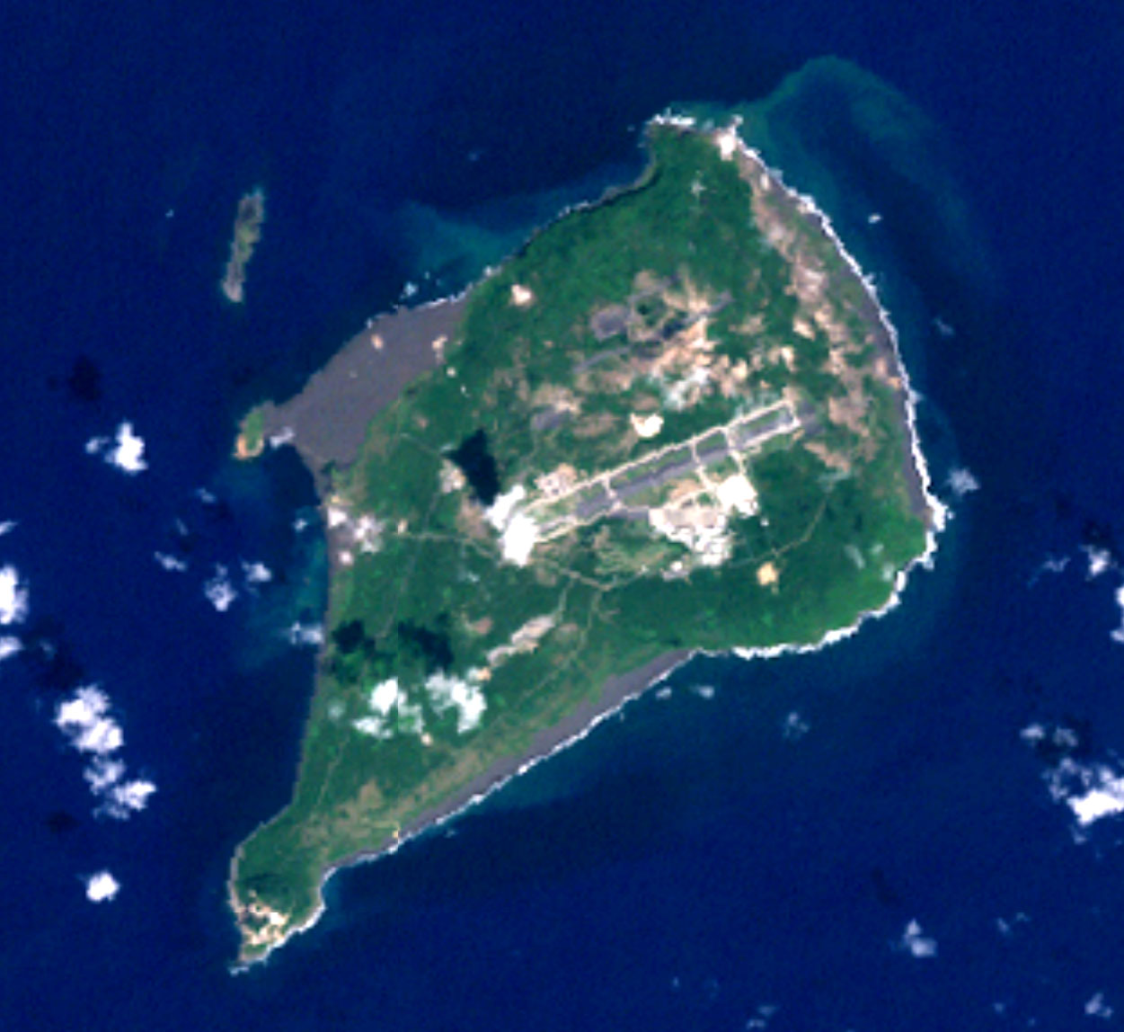
 Landsat photo of Iwo Jima (Iōtō), ca. 1999
Before 1945
Before World War II, Iwo Jima was administered as Iōjima village and was (as it is today) part of Tokyo . A census in June 1943 reported an island civilian population of 1018 (533 males, 485 females) in 192 households in six settlements. The island had a primary school, a Shinto shrine, and a single police officer; it was serviced by a mail ship from Haha-jima once a month, as well as a Nippon Yusen ship once every couple of months. The island's economy relied upon sulfur mining, sugarcane farming, and fishing; an isolated island in the middle of the Pacific Ocean with poor economic prospect, Iwo Jima had to import all rice and consumer goods from the Home Islands.[citation needed]
Even before the beginning of World War II, there was a garrison of the Imperial Japanese Navy at the southern part of Iwo Jima. It was off-limits to the island's civilian population, who already had little contact with the naval personnel, except for trade purposes.
Throughout 1944 there was a massive military buildup on Iwo Jima, in anticipation of a U.S. invasion; in July its civilian population was forcibly evacuated, and no civilians have permanently settled on the island since.
The Battle of Iwo Jima
Main article: Battle of Iwo JimaThe invasion of Iwo Jima began on February 19, 1945, and continued to March 26, 1945. The battle was a major initiative of the Pacific Campaign of World War II. The Marine invasion, known as Operation Detachment, was charged with the mission of capturing the airfields on the island which up until that time had harried U.S. bombing missions to Tokyo. Once the bases were secured, they could then be of use in the impending invasion of the Japanese mainland.
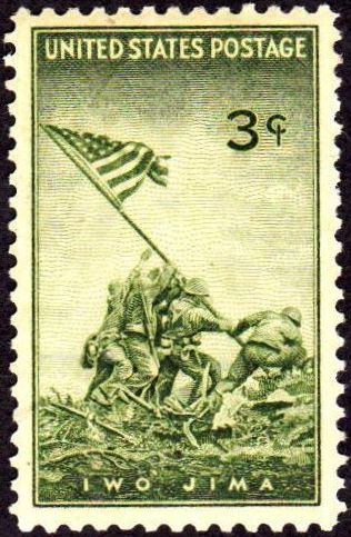
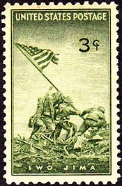 US postage stamp, 1945 issue, commemorating Battle of Iwo Jima.
The battle was marked by some of the fiercest fighting of the War. The Imperial Japanese Army positions on the island were heavily fortified, with vast bunkers, hidden artillery, and 18 kilometres (11 mi) of tunnels.[10][11] The battle was the first U.S. attack on the Japanese Home Islands and the Imperial soldiers defended their positions tenaciously. Of the 21,000 Japanese soldiers present at the beginning of the battle, over 20,000 were killed and only 1,083 taken prisoner.[12]
One of the first objectives after landing on the beachhead was the taking of Mount Suribachi. At the second raising of a flag on the peak, Joe Rosenthal photographed six Marines: Ira Hayes, Mike Strank, Rene Gagnon, Harlon Block, Franklin Sousley, and U.S. Navy corpsman John Bradley raising the U.S. flag on the fourth day of the battle (February 23). The photograph was extremely popular, being reprinted in thousands of publications. It won the Pulitzer Prize for Photography that same year, and ultimately came to be regarded as one of the most significant and recognizable images of the war, and possibly the most reproduced photograph of all time.[1]
Within the next month of fighting, three of the Marines raising the flag were killed: Strank, Block and Sousley. Contrary to popular belief, the famous picture of the six men raising the flag, was not the first time they raised it. The raised it about twenty minutes before hand, and then the photographer got there. The photographer had them take it down so he could get a famous picture of them putting it up "for the first time."
After the fall of Mt. Suribachi in the south, the Japanese still held a strong position throughout the island. General Tadamichi Kuribayashi still had the equivalent of eight infantry battalions, a tank regiment, two artillery and three heavy mortar battalions, plus the 5,000 gunners and naval infantry. With the landing area secure, more troops and heavy equipment came ashore and the invasion proceeded north to capture the airfields and the remainder of the island. Most Japanese soldiers fought to the death. On the night of March 25, a 300-man Japanese force launched a final counterattack. The Marines suffered heavy casualties; more than 100 were killed and another 200 Americans were wounded. The island was officially declared "secured" the following day.
According to the United States Navy “the 36-day (Iwo Jima) assault resulted in more than 26,000 American casualties, including 6,800 dead.”[13] To put that into context, the 82-day Battle of Okinawa lasted from early April until mid-June 1945 and U.S. (5 Army and 2 Marine Corps Divisions) casualties were over 62,000 of whom over 12,000 were killed or missing, while the Battle of the Bulge lasted 40 days (16 Dec 44 – 25 Jan 45) with almost 90,000 U.S. casualties of; 19,000 killed, 47,500 wounded, and 23,000 captured or missing.
After Iwo Jima was declared secured, about three thousand Japanese soldiers were left alive in the island's warren of caves and tunnels. Those who could not bring themselves to commit suicide hid in the caves during the day and came out at night to prowl for provisions. Some did eventually surrender and were surprised that the Americans often received them with compassion—offering them water, cigarettes, or coffee.[14] The last of these stragglers, two of Lieutenant Toshihiko Ohno's men (Ohno's body was never found), Yamakage Kufuku and Matsudo Linsoki, lasted six years, surrendering in 1951[15] (another source gives the date of surrender as January 6, 1949).[16]
The U.S. military occupied Iwo Jima until 1968, when it was returned to Japan.
It has been reported that many of the Japanese remains in Iwo Jima are missing their skulls.[17] It is possible that the souvenir collection of body remains continued also in the immediate post-war period.[17] (See American mutilation of Japanese war dead)
Reunion of Honor
On February 19, 1985, the 40th anniversary of the day that U.S. forces began the assault on the island, veterans from both forces gathered for the Reunion of Honor just a few meters away from the spot where U.S. Marines had landed on the island.[18] During the memorial service a granite plaque was unveiled with the message:
On the 40th anniversary of the battle of Iwo Jima, American and Japanese veterans met again on these same sands, this time in peace and friendship. We commemorate our comrades, living and dead, who fought here with bravery and honor, and we pray together that our sacrifices on Iwo Jima will always be remembered and never be repeated.
It is inscribed on both sides of the plaque, with the English translation facing the beaches where U.S. forces landed and the Japanese translation facing inland, where Japanese troops defended their position.
After that, the Japan-U.S. combination memorial service of the 50th anniversary was held in front of this monument in March 1995. The 55th anniversary was held in 2000, followed by a 60th reunion in March 2005 (see U.S. National Park Service photo below).
-

60th Reunion 2005
-

Reunion of Honor Memorial
Japanese military base
The Japan Maritime Self-Defense Force (JMSDF) operates a naval air base on the island at North Field (IATA: IWO, ICAO: RJAW). The airstrip is 2,650 meters (8,700 ft) long and 60 meters (200 ft) wide. Its orientation is 07/25. The JMSDF is in charge of support, air-traffic control, fueling, and rescue. The Japan Air Self-Defense Force also uses the base. The Japan Ground Self-Defense Force is in charge of explosive-ordnance disposal, and maintains a garrison of 400 troops on the island.[5] Two abandoned airfields from World War II are located nearby, Central Field to the south of the current air base, and an unfinished Japanese airfield to the north of the base, which was improved following the US invasion of the island.
The U.S. Navy's Carrier Air Wing Five, based at the United States Naval Air Facility Atsugi when not embarked/deployed aboard USS George Washington, also uses the base for field carrier landing practice (FCLP). The U.S. Navy still has a 1,639 acres (663 ha) disfunctioned communication facility (Iwo-Jima Communication Site) on the island, while the U.S. Coast Guard's Iwo Jima LORAN-C transmitter facility was transferred to Japan in 1993 and demolished in 1994.
Civilian access to the island is restricted to those attending memorial services for U.S. and Japanese fallen soldiers, construction workers for the naval air base, and meteorological agency officials. The Japanese troops stationed on the island register their residential addresses in Ayase, Kanagawa or Sayama, Saitama for voting, tax, and social security purposes. Officially, there is no population on the island.
U.S. nuclear arms base
Iwo Jima appears to be one of a number of Japanese islands which has been used by the United States to host nuclear arms, according to Robert S. Norris, William M. Arkin, and William Burr writing for the Bulletin of Atomic Scientists in early 2000.[19][20] This is despite a Japanese policy of not allowing nuclear weapons on Japanese soil. Whether the site is currently used for this purpose is unknown, as great secrecy surrounds the United States’ siting of nuclear arms bases; but on December 12, 1999, U.S. Under Secretary for Defense Policy Walter Slocombe told The New York Times, “Our position is that there have been no violations of our obligations under the security treaty and related arrangements.”[21]
Norris, Arkin and Burr concluded however:
There were nuclear weapons on Chichi Jima and Iwo Jima (Iwo To), an enormous and varied nuclear arsenal on Okinawa, nuclear bombs (without their fission cores) stored on the mainland at Misawa and Itazuki airbases (and possibly at Atsugi, Iwakuni, Johnson, and Komaki airbases as well), and nuclear-armed U.S. Navy ships stationed in Sasebo and Yokosuka. […] Chichi Jima, Iwo Jima, and Okinawa were under U.S. occupation, that the bombs stored on the mainland lacked their plutonium and/ or uranium cores, and that the nuclear-armed ships were a legal inch away from Japanese soil. All in all, this elaborate stratagem maintained the technicality that the United States had no nuclear weapons “in Japan.”[21]
Gallery
-
Mount Suribachi on Iwo Jima.
-

Suribachi seen from the northern end of the invasion beach.
-

Volcano crater on Mount Suribachi.
-

Invasion beach seen from the top of Mount Suribachi.
-

A pair of bunkers left over from World War II.
-

View of Suribachi from a beach on the western side of the island.
-

Close up view of Suribachi, scarred from the impacts of munitions during the Battle of Iwo Jima.
-

Sunset at Iwo Jima from the invasion beach.
See also
- Battle of Iwo Jima
- Iwo Jima LORAN-C transmitter
- List of volcanoes in Japan
- Raising the flag on Iwo Jima
- USS Iwo Jima (LHD-7)
Notes
- ^ a b c Global Volcanism Program | Iwo Jima
- ^ a b "地名等の統一に関する連絡協議会 硫黄島の呼称を「いおうじま」から「いおうとう」へ変更". Geographical Survey Institute of Japan. 2007-06-18. http://www.gsi.go.jp/WNEW/PRESS-RELEASE/2007/0618.htm. Retrieved 2007-06-20. (Japanese)
- ^ Patrick, John M. Iwo Jima – Sulphur Island. United States Naval Institute Proceedings 76, no. 9 (September 1950): 1028-1029.
- ^ Kōjien dai rokuban (Japanese dictionary). Iwanami shoten, 2008.
- ^ a b c d Greimel, Hans; Lily Hindy (June 20, 2007). "Japan changes name of Iwo Jima". USA Today. http://www.usatoday.com/news/world/2007-06-20-iwo-jima_N.htm. Retrieved 2007-06-24.
- ^ Japanese Wikipedia article on Suribachiyama, Iwo Jima (Japanese)
- ^ a b Global Volcanism Program:Iwo Jima
- ^ U.S. Geophysics Research Forum, Geophysic Study Committee. Active Tectonics, p. 104. National Academies Press, 1986. ISBN 0309036380
- ^ kaiho.mlit.go.jp (Japanese)
- ^ Letters From Iwo Jima World War II Multimedia Database
- ^ Japanese Defense of Iwo Jima
- ^ Morison, Samuel Eliot (2002) [1960]. Victory in the Pacific, 1945, vol. 14 of History of United States Naval Operations in World War II. Urbana, Ill.: University of Illinois Press. ISBN 0252070658. OCLC 49784806.
- ^ history.navy.mil
- ^ Toland, John (1970). The Rising Sun: The Decline and Fall of the Japanese Empire 1936-1945. New York: Random House. p. 731. OCLC 105915.
- ^ Toland, p. 737
- ^ Cook, Donald. "Capture of Two Holdouts January 6, 1949". No Surrender: Japanese Holdouts. http://www.wanpela.com/holdouts/profiles/kufuku.html. Retrieved 2007-09-11.
- ^ a b Harrison, p.828
- ^ Boardman, Robert (January/February 1986). "A Higher Honor". Discipleship Journal. NavPress. http://www.navpress.com/EPubs/DisplayArticle/1/1.31.5.html. Retrieved 2007-06-20.
- ^ Norris, Robert S.; William M. Arkin, and William Burr (January/February 2000). "Where they were: how much did Japan know?". Bulletin of the Atomic Scientists 56 (1): 11–13, 78–79. doi:10.2968/056001005. http://thebulletin.metapress.com/content/r111482630153263/?p=6fc2fe9c221d4d5786d2d9724d6729c9&pi=4. Retrieved 2009-07-20.[dead link]
- ^ Norris, Robert S.; William M. Arkin, and William Burr (November/December 1999). "NRDC: Nuclear Notebook: Appendix B: Deployments By Country, 1951-1977". Bulletin of the Atomic Scientists 55 (6): 66–67. doi:10.2968/055006019. http://thebulletin.metapress.com/content/d661v3675t623824/fulltext.pdf. Retrieved 2009-07-20.[dead link]
- ^ a b "Allegations of Clandestine US Nuclear Weapons in Japan". Disarmament Diplomacy (The Acronym Institute) (42). December 1999. Archived from the original on 2006-02-03. http://web.archive.org/web/20050622081837/www.thebulletin.org/article.php?art_ofn=jf00norris. Retrieved 2007-06-24.
Categories:- Battle of Iwo Jima
- Former populated places in Japan
- Islands of Tokyo
- Izu-Bonin volcanic arc
- Bonin Islands
- Subduction volcanoes
- Submarine calderas
- Uninhabited islands of Japan
- Volcanic calderas of Japan
- World War II sites


Wikimedia Foundation. 2010.