- Oats Street railway station
-
Oats Street Interchange 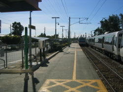
Armadale / Thornlie Line Station code AOS Street Oats Street, Rutland Avenue, Bank Street Suburb Carlisle, East Victoria Park Fare zone 1 Distance from Perth Station 8.2 km (5.1 mi) Stopping patterns All, B, C, T Number of platforms 2 Platform architecture 2 side Station structure Open Station Access by Maze, Bus Stands Transit guard booth Yes Train transfer Yes, between Armadale and Thornlie trains Bus transfer Yes Total number of bus stands 3 Total number of bus routes 5 Park 'n' Ride Yes Lock 'n' Ride No Lifts 0 Escalators 0 Add Value Machines No Public telephones No Public toilets No Oats Street Train Station is a Transperth train station 8.2 km from Perth Train Station, Western Australia, on the Armadale / Thornlie Line.
The introduction of the station as a stop and a connection for the No. 98 and 99 CircleRoute buses in the late 1990s made the station one of the most important transport nodes on the then Armadale Line, a status it retains to this day.
Platforms
Stop No. Platform Line Stopping Pattern Destination Notes [2783] Oats Street Station platforms 99071 1 Armadale / Thornlie All stations, C Perth 99072 2 Armadale / Thornlie All stations, B, C, T Armadale or Thornlie Bus routes
Route Number Destination / Description [11292] Stand 1 99 CircleRoute to Fremantle Train Station via Belmont Forum and Ascot Racecourse [11291] Stand 2 98 CircleRoute to Fremantle Train Station via Curtin University and Southlands [14406] Railway Parade (north-west bound) 285 to Kewdale via Orrong Road 907, 908 Train Replacement Service to Perth [14401] Railway Parade (south-east bound) 907 Train Replacement Service to Armadale 908 Train Replacement Service to Thornlie [14413] Bank Street 282 to Kalamunda Bus Station via Gladys Road 283 to Kalamunda Bus Station via Crystal Brook Road and Lesmurdie Road [13872] Oats Street 282, 283 to Esplanade Busport via Shepperton Road See also
Oats Street
Zone 1Preceding station Transperth Trains network Following station Zone 1towards PerthArmadale Line AllZone 1towards ArmadaleThornlie Line TZone 1towards ThornlieSmartRider Free Transit Zonetowards PerthArmadale Line BZone 2towards ArmadaleArmadale Line CCanningtonZone 2towards ArmadaleTransperth Buses Network Central Area Esplanade Busport · Wellington Street (Perth CAT)Northern Area Eastern Area Western Area South Eastern Area Armadale · Cannington · Curtin University · Gosnells · Kelmscott · Maddington · Oats Street · Thornlie · Victoria ParkSouthern Area Bull Creek · Canning Bridge · Cockburn Central · Kwinana · Kwinana Hub · Murdoch · Rockingham (RCTS) · Warnbro · Wellard · Mandurah†Bus stations in italics do not have an accompanying railway station. †: denotes area outside Perth Metropolitan Area Coordinates: 31°59′13″S 115°54′57″E / 31.986999°S 115.915863°E
Categories:- Railway stations in Perth, Western Australia

Wikimedia Foundation. 2010.