- Ocean bank (topography)
-
See also: Sandbank
Marine habitats 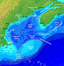
Georges Bank in the Gulf of Maine is a large elevated area of the sea floor, shown in this map as the light blue region at the bottom centre.
Littoral zone Intertidal zone Estuaries Kelp forests Coral reefs Ocean banks Continental shelf Neritic zone Straits Pelagic zone Oceanic zone Seamounts Hydrothermal vents Cold seeps Demersal zone Benthic zone A bank, sometimes referred to as a fishing bank, is an area on the continental shelf which is shallow compared to its surrounding area, such as a shoal or the top of an underwater hill. Somewhat like continental slopes, ocean banks slopes can upwell as tidal and other flows intercept them, resulting sometimes in nutrient rich currents. Because of this, some large banks, such as Dogger Bank and the Grand Banks of Newfoundland, are among the richest fishing grounds in the world.
There are some banks that were reported in the 19th century by navigators, such as Wachusett Reef, whose existence is doubtful.
Contents
Types
Ocean banks may be of volcanic nature. Banks may be carbonate or terrigenous. In tropical areas some banks are submerged atolls. As they are not associated with any landmass, banks have no outside source of sediments. Carbonate banks are typically platforms, rising from the ocean depths, whereas terrigenous banks are elevated sedimentary deposits.[1]
Seamounts, by contrast, are mountains, of volcanic origin, rising from the deep sea, and are steeper, and higher in comparison to the surrounding seabed.[2] Examples are Pioneer and Guide Seamounts, west of the Farallon Islands. The Pioneer Seamount has a depth of 1,000 meters,[2] In other cases, parts of a bank may reach above the water surface, thereby forming islands.[3]
Important banks
The largest banks in the world are:
- Grand Banks of Newfoundland (280,000 km²)[4] - terrigenous bank
- Great Bahama Bank (95,798.12 km², has islands, area without islands)
- Saya de Malha (35,000 km², excluding the separate North bank, least depth 7 m)
- Seychelles Bank (31,000 km², including islands of 266 km²)
- Georges Bank (28,800 km²) - terrigenous bank
- Lansdowne Bank (21,000 km², west of New Caledonia, least depth 3.7 m)
- Dogger Bank (17,600 km², least depth 13 m)
- Little Bahama Bank (14,260.64 km², has islands, area without islands)
- Great Chagos Bank (12,642 km², including islands of 4.5 km²)
- Reed Bank, Spratly Islands (8,866 km², least depth 9 m)
- Caicos Bank, Caicos Islands (7,680 km², including islands of 589.5 km²)
- Macclesfield Bank (6,448 km², least depth 9.2 m)
- North Bank or Ritchie Bank (5,800 km², north of Saya de Malha, least depth <10 m)
- Cay Sal Bank (5,226.73 km², including islands of 14,87 km²)
- Rosalind Bank (4,500 km², lest depth 7.3 m)
See also
Notes
- ^ Morelock, J. (2005). Morphology. Geological Oceanography Program, University of Puerto Rico at Mayagüez (UPRM). Retrieved on: October 11, 2008.
- ^ a b Farallones Marine Sanctuary Association. Islands, Banks & Seamounts: Geologic Features Under the Sea.
- ^ World Wildlife Fund. Deep sea ecology: seamounts. Retrieved on: October 11, 2008.
- ^ Fisheries and Oceans Canada Backgrounder: The Grand Banks and the Flemish Cap. Retrieved on: October 11, 2008.
External links
Fishing industry by region By country 
Fishing banks By species Other areas Fisheries and fishing topic areas Fisheries 
Fishing - Fisherman
- Artisan fishing
- Fishing villages
- Fishing vessels
- Fishing history
Industrial Recreational Techniques Tackle Locations - Fishing by country
- Fishing villages
- Fishing banks
- Fish ponds
- Marine habitats
- Index of fishing articles
- List of fishing topics by subject
- Fisheries glossary
Categories:- Physical oceanography
- Fishing banks
- Undersea banks


Wikimedia Foundation. 2010.