- Offord and Buckden railway station
-
Offord and Buckden 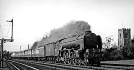
ECML express passing Offord & Buckden station and St Peter's Church in 1955 Location Place Offord Cluny Area Huntingdonshire Grid reference TL218671 Operations Original company Great Northern Railway Pre-grouping Great Northern Railway Post-grouping London and North Eastern Railway History September 1851 Opened as Offord 1 August 1876 Renamed Offord and Buckden 2 February 1959 Closed Disused railway stations in the United Kingdom Closed railway stations in Britain
A B C D–F G H–J K–L M–O P–R S T–V W–ZOfford and Buckden railway station was built by the Great Northern Railway to serve the twin villages of Offord Cluny and Offord D'Arcy in Cambridgeshire, England.
Contents
History
 A 1914 Railway Clearing House map showing (upper centre) railways in the vicinity of Offord & Buckden
The Great Northern Railway main line from London to Peterborough had opened in 1850 including stations at St. Neots and Huntingdon.[1] A station between these, named Offord, was opened just over a year later, in September 1851.[2][3] It was located 56 miles (90 km) from London King's Cross.[4]
On 1 August 1876 the station was renamed Offord and Buckden.[3]
The station closed on 2 February 1959.[3]
Route
Preceding station Historical railways Following station St. Neots
Line and station openGreat Northern Railway
East Coast Main LineHuntingdon
Line and station openNotes
- ^ Butt 1995, pp. 125,204.
- ^ Conolly 1976, p. 11, section C2.
- ^ a b c Butt 1995, p. 176.
- ^ Yonge 2006, map 15C.
References
- Butt, R.V.J. (1995). The Directory of Railway Stations. Yeovil: Patrick Stephens Ltd. ISBN 1 85260 508 1. R508.
- Conolly, W. Philip (January 1976). British Railways Pre-Grouping Atlas and Gazetteer (5th ed.). Shepperton: Ian Allan. ISBN 0 7110 0320 3. EX/0176.
- Yonge, John (September 2006) [1994]. Jacobs, Gerald. ed. 2: Eastern. Railway Track Diagrams (3rd ed.). Bradford on Avon: Trackmaps. ISBN 0 954 9866 2 8.
Closed railway stations in Cambridgeshire Cambridge to Mildenhall railway Barnwell Junction · Fen Ditton Halt · Quy · Bottisham and Lode · Swaffham Prior · Burwell · Exning Road Halt · Fordham · IslehamEly and St Ives Railway Stour Valley Railway Varsity Line Cambridge and Huntingdon railway March to Wisbech Leicester to Peterborough Gt Northern & Gt Eastern Jt Railway Murrow West · Guyhirne · Wimblington · Chatteris · Somersham · Warboys · Ramsey East · Godmanchester · Huntingdon EastStamford to Wansford Ely to Peterborough Line M&GN (Peterborough branch) Kettering to Huntingdon line Kimbolton · Grafham · BuckdenHolme to Ramsey North Benwick goods railway Quakers Drove · West Fen Drove · Burnt House · Whittlesey Dyke · Jones Drove · White Fen · BenwickIpswich to Ely Line and
Newmarket and Chesterford RailwaySoham · Six Mile Bottom · Fulbourn · Cherryhinton · Balsham Road · Abington · Bourne BridgeOther lines Abbots Ripton · Castor · Elton · Fletton · Harston · Offord and Buckden · Orton Waterville · Peakirk · Prickwillow · Yaxley & FarcetCategories:- Disused railway stations in Cambridgeshire
- Former Great Northern Railway stations
- Railway stations opened in 1851
- Railway stations closed in 1959
- East of England railway station stubs


Wikimedia Foundation. 2010.