Ōkura Bakufu

Ōkura Bakufu
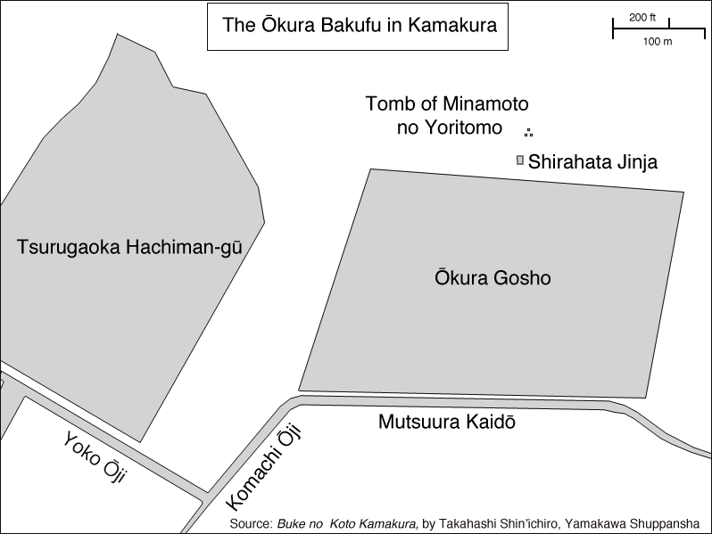
A map of the Ōkura Bakufu

Ōkura Bakufu (大蔵幕府 or 大倉幕府?) (also called Ōkura Gosho (大蔵御所?) is the name of shogun Minamoto no Yoritomo's first government. It took its name from the location in Kamakura, Kanagawa prefecture, where Yoritomo's palace used to stand. Ōkura in Kamakura is defined as the area comprised between Tsurugaoka Hachiman-gū, the Asaina Pass, the Namerigawa river and the Zen temple of Zuisen-ji[1]. The complex extended approximately from the Mutsuura Kaidō to the tomb of Minamoto no Yoritomo, and from the Nishi Mikado River (or Tsurugaoka Hachiman-gū) to the Higashi Mikado river (about 800x600 meters).[2] A black stone stele marks the center of the area where Yoritomo's government used to stand and carries the words[3]:

820 years ago in 1180 Minamoto no Yoritomo built his mansion here. Consolidated his power, he would later rule from it, and his government was therefore called Ōkura Bakufu. He was succeeded by his sons Yoriie and Sanetomo, and this place remained the seat of the government for 46 years until 1225, when his wife Hōjō Masako died. It was then transferred to Utsunomiya Tsuji (宇津宮辻?).
Erected in March 1917 by The Kamakura-machi Seinendan

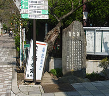
The stele marking the spot where the Ōkura Bakufu used to stand

In 1213 Wada Yoshimori rebelled against the Hōjō regents in the so-called Wada Kassen and his famous son Asahina Yoshihide stormed into the Ōkura Bakufu, burning it into the ground. It was later rebuilt. Many powerful Gokenin had their mansions in Ōkura, which was therefore one of the most important parts of medieval Kamakura[1]. The palace gave their names also to at least two other Kamakura neighborhoods, Nishi Mikado and Higashi Mikado. The two names mean respectively "Western Gate" and "East Gate", from the name of the nearest Ōkura Bakufu gate. The area now called Nikaidō (二階堂?) used to be called Higashi Mikado, and the name is still sometimes used[4]. Kita Mikado still exists as well but does not constitute a chō.

Notes

  1. ^ a b Shirai (1976:41)
  2. ^ Takahashi (2005:011)
  3. ^ Original Japanese text available here
  4. ^ See the stele in Higashi Mikado (Japanese)

References

  • Kamakura Shōkō Kaigijo (2008) (in Japanese). Kamakura Kankō Bunka Kentei Kōshiki Tekisutobukku. Kamakura: Kamakura Shunshūsha. ISBN 978-4-7740-0386-3. 
  • Shirai, Eiji (1976) (in Japanese). Kamakura Jiten. Tōkyōdō Shuppan. ISBN 4-490-10303-4. 
  • Shin'ichirō Takahashi (2005) (in Japanese). Buke no koto, Kamakura. Tokyo: Yamakawa Shuppansha. ISBN 4-634-54210-2. 

Coordinates: 35°19′28.12″N 139°33′40.29″E / 35.3244778°N 139.5611917°E / 35.3244778; 139.5611917


Wikimedia Foundation. 2010.

Игры ⚽ Поможем написать реферат

Look at other dictionaries:

  • Nishi Mikado — A map of Kamakura Nishi Mikado (西御門, Western Gate?) is the name of a neighborho …   Wikipedia

  • Minamoto no Yoritomo — In this Japanese name, the family name is Minamoto . Portrait of Yoritomo, copy of the 1179 original hanging scroll, attributed to Fujiwara Takanobu. Color on silk. In 1995 Michio Yonekura argued that this portrait is not of Yoritomo but of… …   Wikipedia

  • Nikaidō — A map of Kamakura giving Nikaidō s position Nikaidō (二階堂) is the name of one of the administrative units ( towns , chō or machi) of Kamakura, a city located in Kanagawa, Japan, about 50 km south south west of Tokyo. Nikaidō lies immediately… …   Wikipedia

  • Asahina Yoshihide — The Saburō Falls at the beginning of the Asaina Pass, both named after Asahina Yoshihide In this Japanese name, the family name is Asakura . Asahina Yoshihide (朝比奈 義秀 …   Wikipedia

  • Japan — • Called in the language of the country Nihon or Nippon (Land of the Rising Sun), and Dai Nihon or Dai Nippon (Great Japan), situated north west of the Pacific Ocean and east of the Asiatic continent Catholic Encyclopedia. Kevin Knight. 2006.… …   Catholic encyclopedia

  • Économie du Japon — Japon Indicateurs économiques Immeubles de Shinjuku, un des principaux quartiers d affaires de Tōkyō. Monnaie yen …   Wikipédia en Français

  • Kamakura, Kanagawa — Infobox City Japan Name= Kamakura JapaneseName= 鎌倉市 Map Region= Kantō Prefecture= Kanagawa District= Area km2= 39.60 PopDate= January 2008 Population= 173,588 Density km2= 4380 Coords= LatitudeDegrees= 35 LatitudeMinutes= 19 LatitudeSeconds=… …   Wikipedia

  • Japanese students in the United Kingdom — The first Japanese students in the United Kingdom were sent in the nineteenth century by the Chōshū and Satsuma domains, then the Bakufu (Shogunate). Later many studied at Cambridge University and a smaller number at Oxford University until the… …   Wikipedia

  • Kikuchi Dairoku — Dairoku Kikuchi Born 17 March 1855(1855 03 17) Edo, Japan …   Wikipedia

  • Japan–United Kingdom relations — This page describes the history of the relationship between the United Kingdom and Japan. This began in 1600 with the arrival of William Adams (Adams the Pilot, Miura Anjin ) on the shores of Kyūshū at Usuki in Ōita Prefecture. During the Sakoku… …   Wikipedia

Share the article and excerpts

Direct link
Do a right-click on the link above
and select “Copy Link”