- South Park, San Diego
-
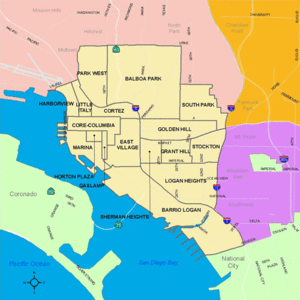

Central portion of San Diego and neighborhood boundaries
South Park is a neighborhood in San Diego, California located east of Balboa Park, and borne out of its southern neighbor Golden Hill. "South Park" is also north of Grant Hill and south of North Park, the boundary being Juniper Street.[1][2] South Park is a distinct neighborhood that also includes the Burlingame historic district[3]
There has been an ongoing controversy over whether or not South Park has historic significance insofar as its recognition as its own neighborhood independent from Golden Hill. Long time Golden Hill resident and owner/proprietor of the Big Kitchen restaurant, Judy Forman, calls her community Golden Hill. According to her “South Park is a name Republican real-estate people want. They want to be detached from Golden Hill because Golden Hill has an [image problem].” [4]The modern boundaries of South Park include the historic neighborhood of Brooklyn Heights, which is not often discussed, one rare relic of it being the still extant Brooklyn Heights Presbyterian Church.
Serious development in the South Park neighborhood started around 1905 with the extension of streetcar service by the Bartlett Webster developing company. In the 1910s, Golden Hill and the area now referred to as South Park became one of the many San Diego neighborhoods connected by the Class 1 streetcars and an extensive San Diego public transit system that was spurred by the Panama-California Exposition of 1915 and built by John D. Spreckels. These streetcars became a fixture of this neighborhood until their retirement in 1939.[5][unreliable source?]
South Park is now considered one of the major historic urban communities of San Diego and has long been proposed as a registered historic district.[6] Other historically significant neighborhoods not far from South Park include Golden Hill and Sherman Heights.
Contents
Description
South Park stands out in San Diego for its tree-lined streets, compact blocks, and walkable business district. Predominantly a single-family residence area with some small apartment buildings and bungalow courts, it is noteworthy for its fine and varied collection of Craftsman and Spanish Colonial Revival style homes built between 1905 and 1930. These include works by Irving Gill, William S. Hebbard, and Richard Requa. Many of the houses are historically designated and an official historic district has been in the pipeline for a number of years.
South Park has been gaining repute for its small businesses since the 1990s, and has long been home to a group of residents diverse in income, age, sexual orientation, and race. Pedestrianism, like in other urban mesa neighborhoods north of Balboa Park, is high relative to the rest of San Diego. The elevation is about 200 feet above sea level but still reasonably flat within most of the area. 30th Street forms its main business district and has been called the nation's best craft beer boulevard by Men's Journal.[7] Chain and franchise businesses are not common in the area; the 7-11 store at Hawthorn Street being the only one. The area is home to several churches, three bicycle shops, coffee houses, popular restaurants, one medium-sized grocery store, taverns and a wine bar, art galleries, a dog wash, a retail tea store, yoga studio and other business concerns. South Park can be found off 30th Street via car or bicycle and is served by the number 2 line bus.[8]
The southern portion of South Park shares the 92102 zip code with Golden Hill and other areas and the northern portion shares the 92104 zip code with North Park. South Park is home to the Albert Einstein Academy Charter School for German language immersion.
South Park has a reputation as a dog-friendly area, supported by one of the few designated dog parks adjacent to a residential area (at Grape Street).
Old House Fair
The Old House Fair is an annual community event in South Park, centered on the intersection of 30th Street and Beech Street. It occurs on a Saturday in the middle of June. Vendors are primarily local businesses selling home furnishings and other items of interest for owners of vintage homes. Musical groups also perform on a stage on Beech Street.[9]
Quarterly South Park Walkabouts
The South Park retail and restaurant community hosts quarterly Walkabouts on Saturday evenings in March, July, October and December. Shops are open late, live music and refreshments are provided, and a free trolley carries attendees from Beech Street to Grape Street to Juniper Street.[10]
References
- ^ http://www.efgh.com/np/
- ^ http://www.city-data.com/forum/san-diego/404003-south-park-2.html
- ^ Covington, Donald. "BURLINGAME: The Tract of Character 1912-1914". The Journal of San Diego History. University of San Diego. http://www.sandiegohistory.org/journal/93summer/burlingame.htm.
- ^ Manson, Bill. "Showdown in the Parks". San Diego Reader. http://www.sandiegoreader.com/news/2010/jul/21/cover-showdown-parks/.
- ^ The Home of the San Diego Historic Class 1Streetcars
- ^ http://sohosandiego.org/histdistricts/southpark1.htm
- ^ http://www.mensjournal.com/top-five-beer-towns
- ^ http://www.sdcommute.com/Services/Route.aspx?r=2
- ^ http://www.theoldhousefair.com.
- ^ http://www.southparkscene.com
External links
- [1] South Park Scene -- businesses website
- [2] Old House Fair
- Greater Golden Hill Planning Committee
- Official City of San Diego website map
- Greater Golden Hill Community Development Corporation
Neighborhoods of San Diego Northern Bay Ho · Bay Park · Carmel Valley · Clairemont · Del Mar Heights · Del Mar Mesa · La Jolla · La Jolla Village · Mission Beach · North City · Pacific Beach · Pacific Highlands Ranch · Torrey Hills · Torrey Pines · University City · Village of La JollaNortheastern Black Mountain Ranch · Carmel Mountain Ranch · Mira Mesa · Miramar · Rancho Bernardo · Rancho Encantada · Rancho Peñasquitos · Sabre Springs · San Pasqual Valley · Scripps Ranch · Sorrento Valley · Sorrento Mesa · Torrey HighlandsEastern Birdland · Kearny Mesa · Mission Valley East · Navajo (Allied Gardens · Del Cerro · Grantville · San Carlos) · Serra Mesa · TierrasantaWestern Burlingame · Hillcrest · Linda Vista · Midtown · Mission Hills · Mission Valley West · Morena · North Park · Ocean Beach · Old Town · Point Loma (La Playa · Liberty Station · Loma Portal · Midway · Point Loma Heights · Roseville-Fleetridge · Sunset Cliffs · Wooded Area) · University HeightsCentral Downtown (Columbia · Core · Cortez Hill · East Village · Gaslamp Quarter · Harborview · Little Italy · Marina) · Balboa Park · Bankers Hill · Barrio Logan · Golden Hill · Grant Hill · Logan Heights · Middletown · Sherman Heights · South Park · StocktonMid-City Adams North · Azalea/Hollywood Park · Castle · Cherokee Point · Chollas Creek · City Heights · Colina del Sol · College Area · Corridor · Darnall · El Cerrito · Fairmont Park · Fox Canyon · Gateway · Islenair · Kensington · Normal Heights · Oak Park · Ridgeview · Redwood Village · Rolando · Swan Canyon · Talmadge · Teralta · WebsterSoutheastern Alta Vista · Bay Terraces · Broadway Heights · Chollas View · Emerald Hills · Encanto · Jamacha-Lomita · Lincoln Park · Mountain View · Mount Hope · Paradise Hills · Shelltown · Skyline · Southcrest · Valencia ParkSouthern Border · Egger Highlands · Nestor · Ocean View Hills · Otay Mesa · Otay Mesa West · Palm City · San Ysidro · Tijuana River ValleyCategories:- Neighborhoods in San Diego, California
- Urban communities in San Diego, California

Wikimedia Foundation. 2010.