- Olympia Regional Airport
-
Olympia Regional Airport 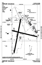
FAA airport diagram IATA: OLM – ICAO: KOLM – FAA LID: OLM Summary Airport type Public Owner Port of Olympia Serves Olympia, Washington Location Tumwater, Washington Elevation AMSL 209 ft / 64 m Coordinates 46°58′10″N 122°54′09″W / 46.96944°N 122.9025°W Website Runways Direction Length Surface ft m 8/26 4,157 1,267 Asphalt 17/35 5,501 1,677 Asphalt Statistics (2008) Aircraft operations 74,169 Based aircraft 148 Source: FAA[1], WSDOT[2], Port of Olympia[3] 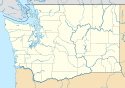
 Olympia AirportLocation of Olympia Airport, Washington
Olympia Regional Airport[1][2][3] (IATA: OLM, ICAO: KOLM, FAA LID: OLM) is a public use airport located four nautical miles (7 km) south of the central business district of Olympia, a city in Thurston County and the capital of the U.S. state of Washington.[1] Formerly known as Olympia Airport, it is owned by the Port of Olympia.[1] It is about one mile (1.6 km) east of Interstate 5, actually within the boundaries of the city of Tumwater which is south of and adjacent to Olympia.
Olympic Flight Museum is located at the Olympia Airport, and Airlift Northwest, the region's air medical transport service uses the airport as one of its medical helicopter bases. The flight museum and the airport play host to a moderate sized air show each June.
The airport's industrial park, 300 acres (1.2 km2) in extent, includes a U.S. Department of Commerce designated Free Trade Zone.
Contents
History
The airport served as a satellite of nearby McChord Field (now AFB) during World War II, and commercial aviation history at the Olympia Airport extends to the 1920s. The airport now supports large corporate jets, cargo aircraft, military helicopters and has a back-up runway lighting system for uninterrupted operations. Olympia Airport also has an Instrument Landing System and backup power system for operations during bad weather or low visibility.
An FAA funded $15 million improvement project to make the airport a safer facility was completed in September, 2008, focusing on runway line-of-sight improvements and enhanced signage. In the late 1990s, the airport's runway protection zone was extended with the purchase of $5.5 million worth of land on each end of the primary runway and an above ground fuel facility was constructed.
Facilities and aircraft
Olympia Regional Airport covers an area of 1,632 acres (660 ha) at an elevation of 209 feet (64 m) above mean sea level. It has two asphalt paved runways: 17/35 is 5,501 by 150 feet (1,677 x 46 m) and 8/26 is 4,157 by 150 feet (1,267 x 46 m).[1] The airport has a passenger terminal, an air traffic control tower and a full-instrument landing approach system.
The field is home to flight instruction, both fixed wing and helicopter, major oxygen and aircraft maintenance facilities, the Washington State Patrol aviation division, and a key navigational aid (Olympia VOR) for commercial flights inbound to Seattle-Tacoma International Airport and general aviation aircraft in the region.
For the 12-month period ending September 30, 2008, the airport had 74,169 aircraft operations, an average of 203 per day: 96% general aviation, 3% air taxi, and 1% military. At that time there were 148 aircraft based at this airport: 74% single-engine, 8% multi-engine, 3% jet and 14% helicopter.[1]
See also
References
 This article incorporates public domain material from websites or documents of the Air Force Historical Research Agency.
- ^ a b c d e f FAA Airport Master Record for OLM (Form 5010 PDF). Federal Aviation Administration. Effective 29 July 2010.
- ^ a b Olympia Regional Airport. Washington State DOT. Accessed 17 August 2010.
- ^ a b Olympia Regional Airport. Port of Olympia. Accessed 17 August 2010.
External links
- Olympia Regional Airport at Port of Olympia web site
- FAA Terminal Procedures for OLM, effective 20 October 2011
- Resources for this airport:
- AirNav airport information for KOLM
- ASN accident history for OLM
- FlightAware airport information and live flight tracker
- NOAA/NWS latest weather observations
- SkyVector aeronautical chart, Terminal Procedures for KOLM
Airfields Group Training Stations · Replacement Training Stations · Tactical Airfields
Units Commands IV Bomber Command · IV Fighter Command · IV Air Support CommandWings 21st Bombardment · Los Angeles Fighter · San Diego Fighter · San Francisco Fighter · Seattle FighterGroups Bombardment 12th Bombardment · 30th Bombardment · 41st Bombardment · 42d Bombardment · 47th Bombardment · 380th Bombardment · 385th Bombardment · 389th Bombardment · 392d Bombardment · 399th Bombardment · 449th Bombardment · 450th Bombardment · 451st Bombardment · 453rd Bombardment · 454th Bombardment · 455th Bombardment · 456th Bombardment · 461st Bombardment · 463d Bombardment · 465th Bombardment · 466th Bombardment · 470th Bombardment · 483rd Bombardment · 486th Bombardment · 491st Bombardment · 492d BombardmentFighter 1st Fighter · 14th Fighter · 20th Fighter · 35th Fighter · 51st Fighter · 55th Fighter · 78th Fighter · 81st Fighter · 82d Fighter · 328th Fighter · 329th Fighter · 339th Fighter · 354th Fighter · 360th Fighter · 363rd Fighter · 364th Fighter · 369th Fighter · 367th Fighter · 372d Fighter · 412th Fighter · 473d Fighter · 474th Fighter · 478th Fighter · 479th FighterReconnaissance 68th Reconnaissance · 69th ReconnaissanceTroop Carrier Categories:- Airports in Washington (state)
- Airfields of the United States Army Air Forces in Washington (state)
- Olympia, Washington
- Transportation in Thurston County, Washington
- USAAF Fourth Air Force Replacement Training Stations
- Buildings and structures in Thurston County, Washington


Wikimedia Foundation. 2010.