- Mundijong, Western Australia
-
Mundijong
Perth, Western Australia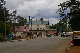
Paterson Street, Mundijong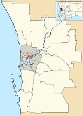
 Mundijong
Population: 877 (2006 Census)[1] Established: 1890s Postcode: 6123 Area: 15 km² (5.8 sq mi) Location: LGA: Shire of Serpentine-Jarrahdale State District: Darling Range Federal Division: Canning Suburbs around Mundijong: Oldbury Cardup Cardup Oldbury Mundijong Whitby Mardella Mardella Jarrahdale Coordinates: 32°17′02″S 115°58′23″E / 32.284°S 115.973°E
Mundijong is an outer suburb of the Western Australian capital city of Perth. Originally named Jarrahdale Junction, it was at the junction of the Rockingham-Jarrahdale line and the government line from Perth to Bunbury which was built in 1893. At the 2006 census, Mundijong had a population of 877.[1]
A town grew up around the junction, and a timber depot which included a large planing mill was constructed. The town was first declared as "Manjedal" in 1893 as it was thought to be the Aboriginal name of the area. In 1897 this was found to be incorrect, and the name was changed to Mundijong.[2] Mundijong also serves as a stop on the Australind train from Perth to Bunbury.
References
- ^ a b Australian Bureau of Statistics (25 October 2007). "Mundijong (L) (Urban Centre/Locality)". 2006 Census QuickStats. http://www.censusdata.abs.gov.au/ABSNavigation/prenav/LocationSearch?collection=Census&period=2006&areacode=UCL520000&producttype=QuickStats&breadcrumb=PL&action=401. Retrieved 18 July 2011.
- ^ Western Australian Land Information Authority. "History of metropolitan suburb names". http://www.landgate.wa.gov.au/corporate.nsf/web/History+of+metropolitan+suburb+names. Retrieved 2007-05-25.
Towns and suburbs of the Shire of Serpentine-Jarrahdale | Perth | Western Australia Byford · Cardup · Darling Downs · Hopeland · Jarrahdale · Karrakup · Keysbrook · Mardella · Mundijong · Oakford · Oldbury · Serpentine · Whitby ·
Preceding station Transwa Trains network Following station towards PerthAustralind towards BunburyCategories:- Towns in Western Australia
- Australian Aboriginal placenames
- Western Australia geography stubs


Wikimedia Foundation. 2010.