- Onega, Russia
-
For other uses, see Onega (disambiguation).
Onega (English)
Онега (Russian)- Town[1] - 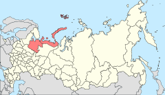
Location of Arkhangelsk Oblast in Russia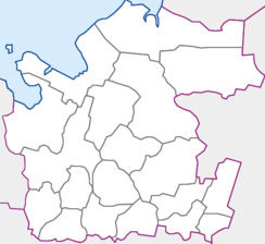
 Onega
OnegaCoordinates: 63°55′N 38°05′E / 63.917°N 38.083°ECoordinates: 63°55′N 38°05′E / 63.917°N 38.083°E 
Coat of Arms of Onega from 1780 Administrative status Country Russia Federal subject Arkhangelsk Oblast Administratively subordinated to Onega Town of Oblast Significance[2] Administrative center of Onega Town of Oblast Significance, Onezhsky District[1] Municipal status (as of February 2010) Municipal district Onezhsky Municipal District[3] Urban settlement Onezhskoye Urban Settlement[3] Administrative center of Onezhsky Municipal District, Onezhskoye Urban Settlement[3] Statistics Population (2010 Census,
preliminary)21,359 inhabitants[4] Population (2002 Census) 23,430 inhabitants[5] Time zone MSD (UTC+04:00)[6] Town status since 1780[7] Onega (Russian: Оне́га) is a town in the northwest of Arkhangelsk Oblast, Russia, situated at the mouth of the Onega River, a few kilometers from the shore of the Onega Bay of the White Sea. Administratively, it is incorporated as a town of oblast significance (one of the six in Arkhangelsk Oblast). It also serves as the administrative center of Onezhsky District, by which it is completely surrounded but is not administratively a part of. Municipally, it is incorporated as Onezhskoye Urban Settlement of Onezhsky Municipal District.[3] Population: 21,359 (2010 Census preliminary results);[4] 23,430 (2002 Census);[5] 26,070 (1989 Census).[8]
Nowadays, Onega is a minor port on a bay on the White Sea, which routinely freezes in winter. The town is also served by the Arkhangelsk–Murmansk rail line.
Contents
History
The Pomor village of Ust-Onega (Усть-Оне́га) was first mentioned in Novgorodian documents in 1137. It also appears on a 13th-century map of Novgorod lands. The settlement was chartered on August 19, 1780, after Pyotr Shuvalov had sold his rights to fell timber to English industrialists who built several sawmills there. Since 1784, Onega was the administrative center of Onezhsky Uyezd.
Ill-fated young captain, oceanographer and linguist Alexander Kuchin (1888-1913?), was born in Onega.
Economy
Industry
The economy of the town is based on timber industry. There is also production of construction materials.[9]
Transport
Onega is a station on a railway line which branches off in Obozerskaya railway station from the railroad between Moscow and Arkhangelsk and runs west to Onega and Belomorsk where it joins the railroad between Petrozavodsk and Murmansk. The railroad was built during the World War II to secure the transport of goods from the harbor of Murmansk to central Russia.
Onega is connected to Severodvinsk by a road. There are no all-seasonal roads on the left bank of the Onega River.
The Onega is navigable downstream from the selo of Porog; there is regular passenger navigation. There is also limited passenger service on the Onega Bay.
The Onega is served by the Onega Airport which has weekly passenger flights to Arkhangelsk and to the selo of Purnema on the Onega Peninsula. Close to the town, there is also an uncompleted military air base, Onega Andozero.
Oil transport
In 2003, the Russian inland oil shipping company Volgotanker started using the White Sea-Baltic Canal for exporting fuel oil. The scheme involved delivering oil by river tanker, over the canal and into a floating transfer terminal near the Osinki Island in the Onega Bay, 36 km north-east of the port of Onega, for transfer to Latvian seagoing tankers.
On September 1, 2003, a collision between Volgotanker's Nefterudovoz-57M and the Latvian Zoja-I during such a transfer caused an oil spill. As a result, fines were paid, and the company did not get a permit for similar operations in the following year.[10]
As of 2005, plans were in the works, by a different operator (ARM-Nefteservis), to set up oil transfer operations at a floating terminal off Osinki Island again. This time, oil would be delivered by the railway to the Shendunets station nearby, and pumped to the floating terminal by an underwater pipeline.
Culture and recreation
The only state museum in the District is the Onega Historical Museum.[11]
Kiy Island, offshore from Onega, and the surrounding ice fields were used as the location for filming A Captive in the Land in the winter of 1989–1990. The island is the site of a monastery, Holy Cross Monastery, which was closed during the era of religious persecution by the Soviets.
Climate
Climate data for Onega Month Jan Feb Mar Apr May Jun Jul Aug Sep Oct Nov Dec Year Average high °C (°F) −10
(14)−7
(19)−1
(30)3
(37)11
(52)17
(63)20
(68)16
(61)11
(52)3
(37)−1
(30)−6
(21)5 Daily mean °C (°F) −12
(10)−10
(14)−4
(25)7
(45)13
(55)16
(61)13
(55)8
(46)2
(36)−3
(27)−8
(18)2 Average low °C (°F) −16
(3)−13
(9)−7
(19)−2
(28)3
(37)9
(48)12
(54)9
(48)5
(41)−5
(23)−11
(12)−1 Avg. precipitation days 26 23 23 19 17 17 15 18 20 24 25 28 255 Source: Weatherbase[12] References
Notes
- ^ a b Государственный комитет Российской Федерации по статистике. Комитет Российской Федерации по стандартизации, метрологии и сертификации. №ОК 019-95 1 января 1997 г «Общероссийский классификатор объектов административно-территориального деления. Код 11 408 000», в ред. изменения №168/2011 от 1 октября 2011 г. (State Statistics Committee of the Russian Federation. Committee of the Russian Federation on Standardization, Metrology, and Certification. #OK 019-95 January 1, 1997 Russian Classification of Objects of Administrative Division . Code 11 408 000, as amended by the Amendment #168/2010 of October 1, 2011. ).
- ^ Law #65-5-OZ
- ^ a b c d Архангельское областное Собрание депутатов. Областной закон №258-внеоч.-ОЗ от 23 сентября 2004 г. «О статусе и границах территорий муниципальных образований в Архангельской области (текст в ред. от 15 февраля 2010 г.)», в ред. Областного закона №309-23-ОЗ от 7 июля 2011 г «О внесении изменений и дополнений в отдельные Областные законы в сфере организации и осуществления местного самоуправления». Вступил в силу со дня официального опубликования. Опубликован: "Волна", №38, 8 октября 2004 г. (Arkhangelsk Oblast Council of Deputies. Oblast Law #258-vneoch.-OZ of September 23, 2004 On the Status and Borders of the Territories of the Municipal Formations in Arkhangelsk Oblast (text of rev. of February 15, 2010), as amended by the Oblast Law #309-23-OZ of July 7, 2011 On Amending and Supplementing Several Oblast Laws on the Subject of Organization and Implementation of the Local Self-Government. Effective as of the day of the official publication).
- ^ a b Федеральная служба государственной статистики (Federal State Statistics Service) (2011). "Предварительные итоги Всероссийской переписи населения 2010 года (Preliminary results of the 2010 All-Russian Population Census)" (in Russian). Всероссийская перепись населения 2010 года (All-Russia Population Census of 2010). Federal State Statistics Service. http://www.perepis-2010.ru/results_of_the_census/results-inform.php. Retrieved 2011-04-25.
- ^ a b Федеральная служба государственной статистики (Federal State Statistics Service) (2004-05-21). "Численность населения России, субъектов Российской Федерации в составе федеральных округов, районов, городских поселений, сельских населённых пунктов – районных центров и сельских населённых пунктов с населением 3 тысячи и более человек (Population of Russia, its federal districts, federal subjects, districts, urban localities, rural localities—administrative centers, and rural localities with population of over 3,000)" (in Russian). Всероссийская перепись населения 2002 года (All-Russia Population Census of 2002). Federal State Statistics Service. http://www.perepis2002.ru/ct/doc/1_TOM_01_04.xls. Retrieved 2010-03-23.
- ^ Правительство Российской Федерации. Постановление №725 от 31 августа 2011 г. «О составе территорий, образующих каждую часовую зону, и порядке исчисления времени в часовых зонах, а также о признании утратившими силу отдельных Постановлений Правительства Российской Федерации». Вступил в силу по истечении 7 дней после дня официального опубликования. Опубликован: "Российская Газета", №197, 6 сентября 2011 г. (Government of the Russian Federation. Resolution #725 of August 31, 2011 On the Composition of the Territories Included into Each Time Zone and on the Procedures of Timekeeping in the Time Zones, as Well as on Abrogation of Several Resolutions of the Government of the Russian Federation. Effective as of after 7 days following the day of the official publication).
- ^ Энциклопедия Города России. Moscow: Большая Российская Энциклопедия. 2003. p. 329. ISBN 5-7107-7399-9.
- ^ "Всесоюзная перепись населения 1989 г. Численность наличного населения союзных и автономных республик, автономных областей и округов, краёв, областей, районов, городских поселений и сёл-райцентров. (All Union Population Census of 1989. Present population of union and autonomous republics, autonomous oblasts and okrugs, krais, oblasts, districts, urban settlements, and villages serving as district administrative centers.)" (in Russian). Всесоюзная перепись населения 1989 года (All-Union Population Census of 1989). Demoscope Weekly (website of the Institute of Demographics of the State University—Higher School of Economics. 1989. http://demoscope.ru/weekly/ssp/rus89_reg.php. Retrieved 2010-03-23.
- ^ "Общие сведения" (in Russian). МО "Онежский район". http://www.onega.ru/economy/date.htm. Retrieved August 16, 2011.
- ^ Alexei Bambulyak, Bjorn Franzen. Transportation of oil from the Russian part of the Barents Sea region, as of January 2005 (Russian)
- ^ "Онежский историко-мемориальный музей" (in Russian). Музеи России. http://www.museum.ru/M943. Retrieved 19 August 2011.
- ^ "Weatherbase: Historical Weather for Onega". http://www.weatherbase.com/weather/weather.php3?s=17422&refer=&units=metric&cityname=Mezen%27-Severo-Zapadniy-Fed.-Okrug-Russia. Retrieved August 25, 2011.
Sources
- Архангельское областное Собрание депутатов. Областной закон №65-5-ОЗ от 23 сентября 2009 г. «Об административно-территориальном устройстве Архангельской области», в ред. Областного закона №150-12-ОЗ от 4 мая 2010 г «О внесении изменений и дополнений в отдельные областные законы». Вступил в силу через десять дней со дня официального опубликования. Опубликован: "Волна", №43, 6 октября 2009 г. (Arkhangelsk Oblast Council of Deputies. Oblast Law #65-5-OZ of September 23, 2009 On the Administrative and Territorial Structure of Arkhangelsk Oblast, as amended by the Oblast Law #150-12-OZ of May 4, 2010 On Amending and Supplementing Certain Oblast Laws. Effective as of the day ten days after the official publication).
External links
Administrative divisions of Arkhangelsk Oblast Administrative center: ArkhangelskCities and towns Arkhangelsk · Kargopol · Koryazhma · Kotlas · Mezen · Mirny · Naryan-Mar · Novodvinsk · Nyandoma · Onega · Severodvinsk · Shenkursk · Solvychegodsk · Velsk

Districts (raions) Kargopolsky · Kholmogorsky · Konoshsky · Kotlassky · Krasnoborsky · Lensky · Leshukonsky · Mezensky · Novaya Zemlya · Nyandomsky · Onezhsky · Pinezhsky · Plesetsky · Primorsky · Shenkursky · Solovetsky · Ustyansky · Velsky · Verkhnetoyemsky · Vilegodsky · VinogradovskyCategories:- Cities and towns in Arkhangelsk Oblast
- White Sea
- Populated places established in 1780


Wikimedia Foundation. 2010.