- Oplocany
-
Oplocany — Municipality — 
Coat of arms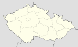
 Oplocany
Coordinates: 49°24′32″N 17°15′57″E / 49.40889°N 17.26583°ECoordinates: 49°24′32″N 17°15′57″E / 49.40889°N 17.26583°E Country  Czech Republic
Region Olomouc District Přerov Area – Total 5.45 km2 (2.1 sq mi) Elevation 200 m (656 ft) Population (2006) – Total 312 – Density 57.2/km2 (148.3/sq mi) Postal code 751 01 Website http://www.oplocany.cz Oplocany is a village and municipality (obec) in Přerov District in the Olomouc Region of the Czech Republic.
The municipality covers an area of 5.45 square kilometres (2.10 sq mi), and has a population of 312 (as at 3 July 2006).
Oplocany lies approximately 15 kilometres (9 mi) west of Přerov, 21 km (13 mi) south of Olomouc, and 219 km (136 mi) east of Prague.
References
Towns and villages of Přerov District Bělotín · Beňov · Bezuchov · Bochoř · Bohuslávky · Brodek u Přerova · Buk · Býškovice · Čechy · Čelechovice · Černotín · Císařov · Citov · Dobrčice · Dolní Nětčice · Dolní Těšice · Dolní Újezd · Domaželice · Dřevohostice · Grymov · Hlinsko · Horní Moštěnice · Horní Nětčice · Horní Těšice · Horní Újezd · Hrabůvka · Hradčany · Hranice · Hustopeče nad Bečvou · Jezernice · Jindřichov · Kladníky · Klokočí · Kojetín · Kokory · Křenovice · Křtomil · Lazníčky · Lazníky · Lhota · Lhotka · Lipník nad Bečvou · Lipová · Líšná · Lobodice · Malhotice · Měrovice nad Hanou · Milenov · Milotice nad Bečvou · Nahošovice · Nelešovice · Oldřichov · Olšovec · Opatovice · Oplocany · Oprostovice · Osek nad Bečvou · Paršovice · Partutovice · Pavlovice u Přerova · Podolí · Polkovice · Polom · Potštát · Přerov · Přestavlky · Prosenice · Provodovice · Radíkov · Radkova Lhota · Radkovy · Radotín · Radslavice · Radvanice · Rakov · Říkovice · Rokytnice · Rouské · Šišma · Skalička · Soběchleby · Sobíšky · Špičky · Stará Ves · Stříbrnice · Střítež nad Ludinou · Sušice · Teplice nad Bečvou · Tovačov · Troubky · Tučín · Turovice · Týn nad Bečvou · Uhřičice · Ústí · Veselíčko · Věžky · Vlkoš · Všechovice · Výkleky · Zábeštní Lhota · Žákovice · Zámrsky · Želatovice
This Olomouc Region location article is a stub. You can help Wikipedia by expanding it.

