- Ordos Loop
-
 Yellow River
 Provincial boundaries. The Loess Plateau is shaded. The yellow area is Inner Mongolia and Ningxia.
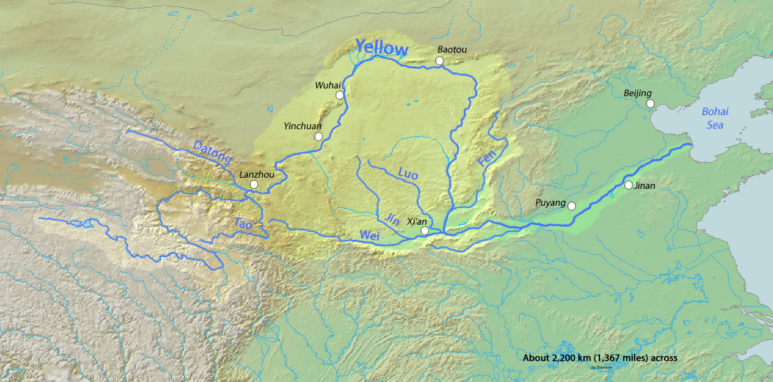
The Ordos (Chinese: 鄂尔多斯; pinyin: Èěrduōsī) Loop is a region of China west of Beijing. The Yellow River flows north-northeast, then east, and then south forming three sides of an imperfect rectangle. The south side is formed by the Wei River which rises not far from the southwest corner and flows east to the southeast corner. Clockwise from the southwest corner the sides of the 'rectangle' are about 400, 200, 375, and 350 miles. At the southeast corner the Yellow River turns east and finds its way through the mountains at the Hangu Pass onto the North China Plain.
Rainfall and therefore population decreases rapidly as one moves north. The Wei River valley on the south is densely populated and is one of the ancient centers of Chinese civilization. The north is grassland and desert (Ordos desert) and is part of Inner Mongolia. The Great Wall of China cuts across the center roughly separating the nomadic north from the agricultural south. The Ordos region proper is the area north of the wall. Although this rectangular area is obvious on a map, the north and south are so different that the region cannot be said to have a common history.To the south of the Wei valley are the high Qin Mountains which separate it from the valley of the Han River, a tributary of the Yangtze River. Further south and somewhat west is the Sichuan basin. To the east are the Lüliang Mountains which form the west side of the Shanxi Plateau. To the north and northwest are the grasslands of Inner Mongolia. The southwest corner merges into the Tibetan Plateau.
An ancient tradition says that the Chinese people entered China by travelling down the Wei River. By about 1000 BC Chinese civilization was centered on the west side of the North China Plain with an extension up the Wei valley and a northern extension up the Fen River. The lower Wei valley is still one of the most densely populated areas in China. Rulers based in the Wei valley had an advantage since the mountains to the east made a natural fortification and war horses were readily available from the northern grasslands. The Zhou dynasty and the Qin dynasty started in the Wei valley. Xi'an on the lower Wei was several times the capital of China. By the Tang dynasty the economic center of China had shifted to the Yangzi valley and the Wei region became partly dependent of food imported up the Grand Canal.
To the north of the Wei valley is the Loess Plateau with its many gullies and cave houses. It is loess from this region that makes the Yellow River yellow. Because of its low and variable rainfall the region was once notorious for drought and famine. Underlying the loess plateau is one of the largest coal beds in China. North and west of the loess plateau the grassland and desert belongs historically and culturally to Mongolia.
 Approximate area of Chinese civilization during the Spring and Autumn period. Note the extension up the Wei valley
Along the two rivers: At the southwest corner near where the Yellow River emerges from the Tibetan Plateau is Lanzhou, the westernmost large city in north China and the capital of Gansu. To the west of Lanzhou is Xining from whence caravans (and now the railway) started for Lhasa. North of Xining the Gansu or Hexi corridor runs along the northern edge of the Tibetan Plateau. This and the Wei valley was the main silk road route from China proper to the Tarim basin and westward. Downriver (north) from Lanzhou is a gorge through Gaolan County and Baiyin. The river emerges from the mountains and enters Ningxia near Zhongwei. It runs east with the Tengger Desert in Inner Mongolia to the north and hills to the south. It turns north through dry country to past the Qingtongxia dam to the irrigated area around Wuzhong City. It continues north past Yinchuan, the capital of Ningxia. To the west are the Helan Mountains. The river leaves the northern tip of Ningxia south of Wuhai, flows through desert and enters a large irrigated area at Dengkou. At the northwest corner the Lang Shan mountains force the river to turn east near Linhe. Here there is an irrigated area between the mountains and river and desert to the southeast. Near the center of the northern stretch is the large town and irrigated area of Baotou. The main road south runs from Baotou to Xian. About 70 miles northeast of the northeast bend is Hohot, the capital of Inner Mongolia. The river turns south, enters the loess plateau and forms a gorge at least 200 feet below the surrounding hills. There are no large towns in this region. There is a dam apparently called Wanjia and another further south and then the Hukou Waterfall of the Yellow River, the second highest in China. The river leaves the gorge near Hancheng, receives the Fen River from the east and the Wei River from the west. At its juncture with the Wei the Yellow River turns east toward the North China Plain. One can go upstream on the Wei with the Qin Mountains with Mount Hua on the south past Weinan to Xi'an, a former capital of China and now a large city. West of Xi'an is Xinyang, the Qin dynasty capital. The river exits the mountains west of Baoji. There is a dam, the river narrows and becomes yellow and the railroad needs many bridges and tunnels all the way to Tianshui. Upstream various tributaries extend in the direction of Lanzhou.
References
Categories:

Wikimedia Foundation. 2010.