- Orleans, Ontario
-
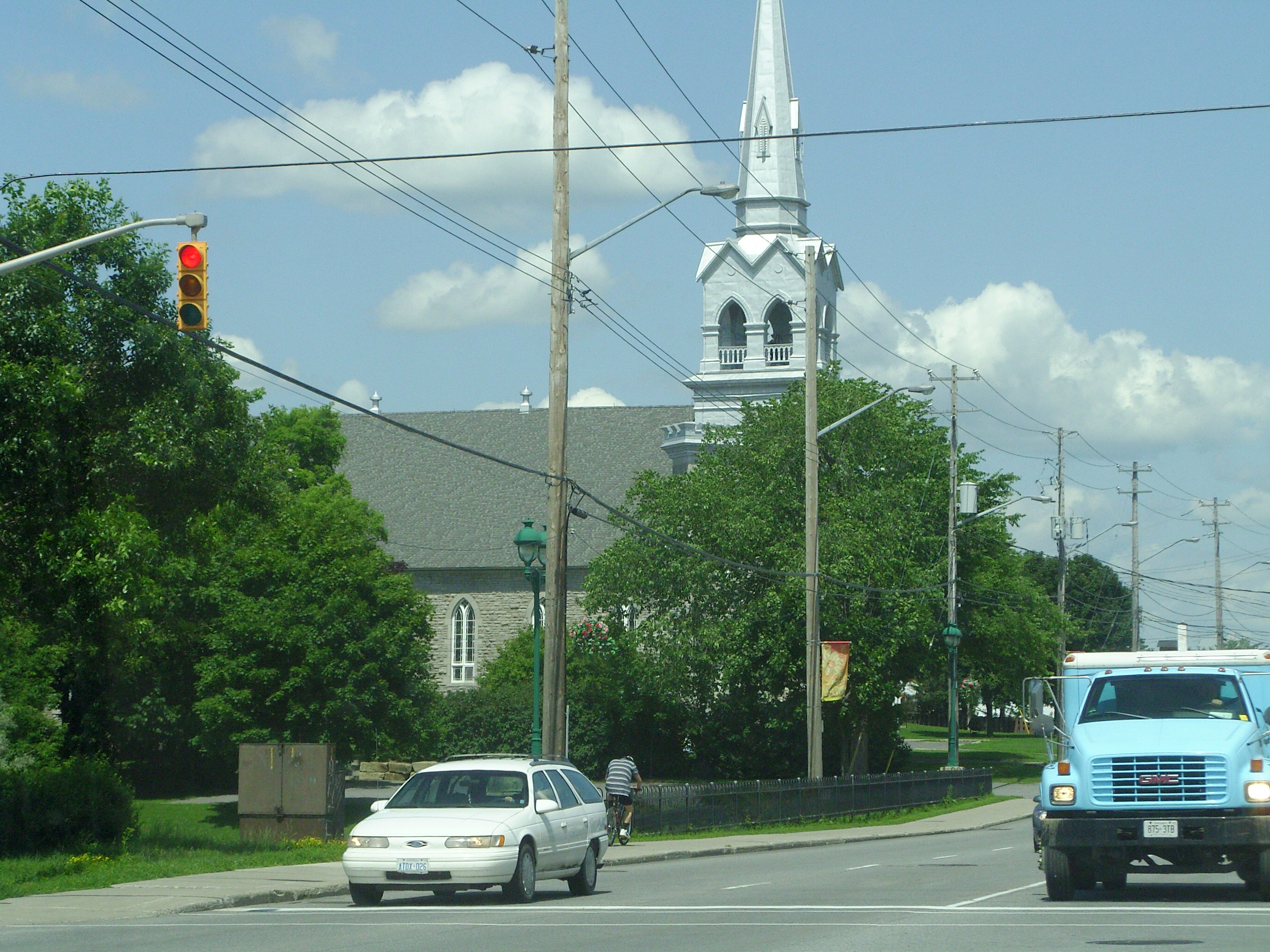
Orleans — Community — Orléans Saint-Joseph Church, built 1830
Country Canada 
Province Ontario 
Parish of St-Joseph-D'Orléans 1830s Police Village of St. Joseph d'Orléans 1922 Community of Orleans 1974 Government – Representatives 8 MPs and 9 MPPs Population (2006) – Total 95,491 Time zone Eastern (EST) (UTC−5) – Summer (DST) EDT (UTC−4) Area code(s) 613, 343 Orleans (
 /ɔrˈliːnz/; French: [ɔʁleɑ̃]), also written Orléans, is a suburban area within the city of Ottawa, Ontario, Canada. It is located in the eastern part of the city along the Ottawa River, about 16 km (9.9 mi) from downtown Ottawa. The Canada 2006 Census gave Orleans a population of 95,491. It became a ward of the City of Ottawa in 2001. Prior to 2001, the community of Orleans was spread over two municipal jurisdictions, the eastern portion being in the pre-amalgamation City of Cumberland, the western portion in the City of Gloucester.
Contents
History
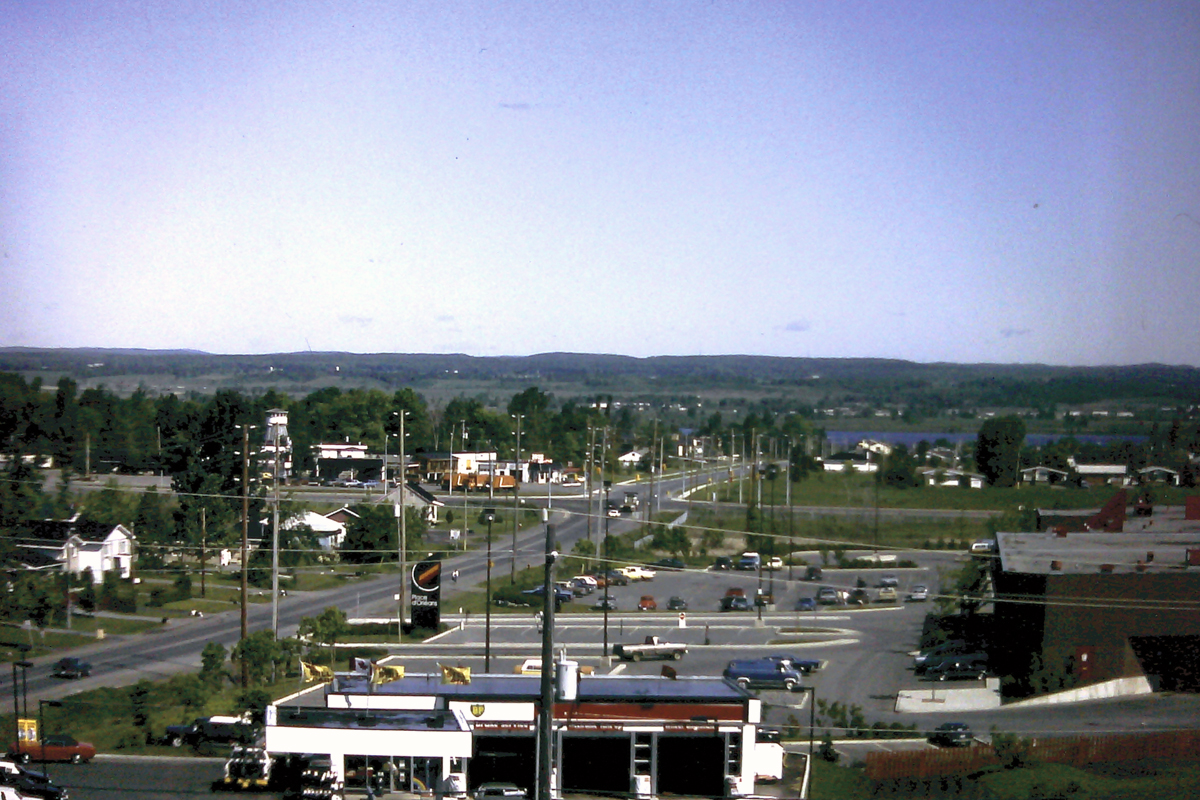
 St. Joseph Blvd. circa 1971. The Duford hill to Queenswood Heights is in the background (behind the Coca-Cola sign). Today, Place D'Orleans would be on the left and the Ruby King restaurant to the right.
The community is thought to have been named by its first postmaster, Théodore Besserer, after his place of birth, the Île d'Orléans near Quebec City. Orleans was an incorporated police village from 1922 to 1974 and was then known as St. Joseph d'Orléans.[1][2] The name corresponds to the main francophone Roman Catholic Church, Paroisse St. Joseph of which the older part of Orleans is built around, along St. Joseph Boulevard.
 Orleans on June 1, 1982 (Place D'Orléans to the left, Champlain St. to the right, the Champlain/Highway 17 intersection and the old Normandy Hotel to the upper right) as viewed from the ridge of the Duford hill leading into Queenswood Heights.
The community's name inspired the name of one its main roads, Jeanne D'Arc Boulevard, which wraps its way around the community. Jeanne d'Arc (Joan of Arc) was a 15th century martyr who led the French army to victory in Orléans, France.
Largely a rural area for a great number of years, the first major suburban subdivision constructed in the community was the Queenswood Heights development starting in the late 1960s. Orleans has continued its steady growth as a suburban community since that time; its southern and easternmost boundaries continue to grow as more houses and businesses are built. Orleans continues to have a sizable French-speaking population, although the proportion of francophones has been decreasing in recent years. The community's name is spelled with an acute accent in French in the relevant regulation to the City of Ottawa Act, reflective of the area's francophone heritage.[citation needed]
Growth has focused around the Place d'Orléans shopping centre, a large shopping centre with over 175 stores situated off Regional Road 174 (the Queensway). Place D'Orléans was originally constructed in 1979 and underwent major expansions in 1984, 1988, and 1990 to arrive at its current size and configuration. Many new business areas along Innes Road between Tenth Line Road and Mer Bleue Road and in the vicinity of Trim Road on the eastern end of the area have also been built recently which serve to diversify the commercial districts of the community. The country-wide housing boom starting from 2000 has also seen an extremely large amount of housing and residential areas being developed in the eastern Orleans area east of Trim Road and south of Innes Road, such as the new community called Avalon. The population and business growth also forced the improvement of Innes Road from a two-lane to a four-lane road in 2005.
Recreational Facilities
 Princess Louise Falls
The Elizabeth Manley skating rink at the Bob MacQuarrie Orléans Recreation Complex (formerly Orléans Recreation Complex[3]) is named for Ms. Manley who trained there and who won a Silver Medal in Women's figure skating in the 1988 Calgary Winter Olympics. It is home to the Gloucester Skating Club and the Canadian Academy of Skating Arts. The skating club is well known for sending skaters to national and international level competitions. The Ray Friel Recreational Complex in the more eastern part of Orleans is home to a public library, a high school, an indoor wave pool, exercising facilities, a physiotherapy clinic, a sports store, a restaurant, two soccer fields and three skating arenas making it one of the main centres for recreation in Orleans.[4]
Along the Ottawa River in the north-east of Orleans, is the parkland of Petrie Island. The parkland is located on several small islands connected by Trim Road, a north-south roadway. The islands are sandbars developed over time in the river. There was a facility extracting sand from the islands, but this has been closed and converted into a large beach area. Petrie Island is home to turtles in some of its sheltered lagoons and has a nature centre for learning more about the local environment. One section of Petrie Island has several homes, but the area is mainly parkland. There is a marina with canoe and kayak rentals.
There are also several nature trails and paths throughout the area including the Bilberry Creek Trail and the Princess Louise Trail through which Taylor Creek runs and which results in a beautiful waterfall near St. Joseph Boulevard.
Neighbourhoods
 Town homes along St. Joseph
 Place D'Orléans Mall
Avalon: Located south of Innes Road, west of Portobello Boulevard and east of Tenth Line Road.
Bilberry Creek: Located east of Jeanne d'Arc Boulevard, north of Highway 174 and east towards the eastern end of the development.
Chapel Hill North: Located north of Innes Road in the Orleans Boulevard area and south of St. Joseph Boulevard.
Chapel Hill South: Located south of Innes Road, and north of Navan Road.
Chaperal: Located south of Innes Rd and north of Blackburn Hamlet Bypass, on Tenth Line Road.
Chateauneuf: Is bounded by St. Joseph Boulevard on the north, Innes Road on the south. The eastern border includes Jeanne D’Arc-Sunview-Des Greives-Barsona-Place Belleterre-Duford Drive, and Orleans Boulevard borders the west.
Chatelaine Village: Located north of Highway 174 toward the Ottawa River and East of Champlain Ave.
Convent Glen: Located north of Highway 174 toward the Ottawa River and west of Jeanne d'Arc Boulevard.
Orleans Wood: Located north of Highway 174 toward the Ottawa River, east of Jeanne d'Arc Boulevard and west of Champlain Street.
Eastridge [1]: Future community situated near Trim Road and Blackburn By-Pass Road south of Notting Gate community.
East Village: Located east of Trim Road, north of Innes Road, and south of Old Montreal Road (St. Joseph Boulevard).
Fallingbrook: Located south of St. Joseph Boulevard, west of Trim Road, north of Innes Road and east of Tenth Line Road.
Mer Bleue (future): This proposed neighbourhood would be located south of Innes Road between Mer Bleue and Tenth Line Road and south towards the Urban limit.
Notting Gate: Located south of Innes Road, east of Portobello Boulevard, and west of Trim Road.
Notting Hill: Located south of Innes Road, east of Portobello Boulevard, and west of Trim Road.
Queenswood Heights: Located south of St. Joseph Boulevard, west of Tenth Line Road, east of the Bilberry Creek Trail ravine and north of Innes Road.
Population history
- 1971 - 6,000
- 1976 - 11,000
- 1981 - 24,000
- 1986 - 47,000
- 1991 - 70,000
- 1996 - 79,000
- 2001 - 84,695
- 2006 - 95,491
Schools and Education
English Catholic
- High school
- St. Matthew High School (Ottawa, Ontario)
- St. Peter Catholic High School
- Elementary
- Blessed Kateri Tekakwitha Catholic School
- Chapel Hill Catholic Elementary School
- Convent Glen Catholic School
- Divine Infant Elementary School
- Our Lady of Wisdom Catholic School
- St. Clare Catholic Elementary School
- St. Francis Of Assisi Elementary School
- St. Teresa Catholic Elementary School
French Catholic
- High school
- Elementary
- École élémentaire catholique Arc-en-ciel
- École élémentaire catholique de la Découverte
- École élémentaire catholique Alain-Fortin
- École élémentaire catholique des Pionniers
- École élémentaire catholique des Voyageurs
- École élémentaire catholique L’Étoile-de-l’Est - http://www.letoiledelest.ca/fr/
- École élémentaire catholique Reine-des-Bois
- École élémentaire catholique Saint-Joseph d'Orléans
- École élémentaire catholique Sainte-Marie
French Public
- High school
- École Secondaire Publique Gisèle-Lalonde
- Elementary
- École élémentaire Des Sentiers
- École élémentaire Jeanne-Sauvé
- École élémentaire L'Odysée
- École élémentaire Le Prélude
English Public
- High school
- Elementary
- Avalon Elementary School
- Convent Glen Elementary School
- Dunning-Foubert Elementary School
- Fallingbrook Community Elementary School
- Forest Valley Elementary School
- Henry Larsen Elementary School
- Maple Ridge Elementary School
- Orleans Wood Elementary School
- Terry-Fox Public Elementary School
- Trillium Public Elementary School
Queenswood Public School Closed 2008(now Coccinelle (Garderie) École La Source)
English Private
There are no English private schools in Orléans.
French Private
There are no French private schools in Orléans.
Main Roads and Streets
 St. Joseph Boulevard
- Orleans Blvd.
- Champlain St.
- Jeanne d'Arc Blvd.
- Des Epinettes Ave.
- St.Joseph Blvd.
- Charlemagne Blvd.
- Innes Rd.
- Tenth Line Rd.
- Trim Rd.
Highway 174
The main highway linking Orleans to central Ottawa to the west is officially known as Ottawa Road 174 and is also known as the Queensway.
- Highway exits
- Trim Rd.
- Tenth Line Rd.
- Jeanne D'Arc
- Place D'Orleans Dr.
References
- ^ "A Historical Timeline for the Township of Gloucester". Gloucester Historical Society. 2010-01-24. http://www.gloucesterhistory.com/history.html. Retrieved 2010-02-13.
- ^ "Municipal / Administrative History". Carleton County GenWeb. 2009. http://www.rootsweb.ancestry.com/~oncarlet/people-municipalhistory.html. Retrieved 2010-02-13.
- ^ "Bob MacQuarrie Recreation Complex – Orléans (Formerly Orléans Recreation Complex)". City of Ottawa. 2009. http://www.ottawa.ca/residents/parks_recreation/facilities/rec_centres/orleans/index_en.html. Retrieved 2009-10-11.
- ^ "The Ray Friel Recreation Complex". City of Ottawa. 2009. http://ottawa.ca/residents/parks_recreation/facilities/rec_centres/rayfriel/generalinfo/index_en.html. Retrieved 2009-10-11.
External links
- Details of the future Mer Bleue community
- East End community design plan
- Team Ottawa-Orléans was established in March 2005 to aid the communities of Orleans to provide a comprehensive approach to the development of the area in particular with respect to infrastructure development.
- Orleans Online: local news, sports, classifieds and business directory online
- Friends of Petrie Island
Coordinates: 45°28′01″N 75°31′01″W / 45.467°N 75.517°W
Categories:- Neighbourhoods in Ottawa
- Former municipalities now in Ottawa


Wikimedia Foundation. 2010.