- Ketchikan International Airport
-
Ketchikan International Airport 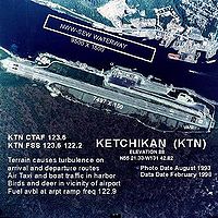
IATA: KTN – ICAO: PAKT – FAA LID: KTN Location of airport in Alaska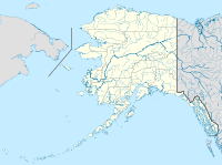
 KTN
KTNSummary Airport type Public Owner State of Alaska DOT&PF - Southeastern Region Serves Ketchikan, Alaska Elevation AMSL 88 ft / 27 m Coordinates 55°21′20″N 131°42′50″W / 55.35556°N 131.71389°W Runways Direction Length Surface ft m 11/29 7,500 2,286 Asphalt NWW/SEW 9,500 2,896 Water Statistics (2006) Aircraft operations 16,208 Based aircraft 13 Source: Federal Aviation Administration[1] Ketchikan International Airport (IATA: KTN, ICAO: PAKT, FAA LID: KTN) is a state-owned public-use airport located one nautical mile (2 km) west of the central business district of Ketchikan, a city in Ketchikan Gateway Borough in the U.S. state of Alaska.[1]
The airport is located on Gravina Island, just west of Ketchikan on the other side of the Tongass Narrows. Passengers must take a seven-minute[2] ferry ride across the water to get to the airport from the town.
Contents
History
Around the World War II era, air service to Ketchikan was possible using an old military airfield on Annette Island. Aircraft used in that era included the Grumman Goose and Catalina PBY. The current airport was opened on August 4, 1973 and dedicated the following day. The airport opening was the culmination of an effort by local residents, a 1965 study by the Alaska State Division of Aviation, another study in 1967 choosing the current site on Gravina Island, and land clearing in 1969.[3]
Facilities and aircraft
Ketchikan International Airport covers an area of 2,600 acres (1,100 ha) at an elevation of 88 feet (27 m) above mean sea level. It has one runway designated 11/29 with 7,500 x 150 ft (2,286 x 46 m) asphalt pavement. It also has a seaplane landing area designated NWW/SEW which measures 9,500 x 1,500 ft (2,896 x 457 m).[1]
For the 12-month period ending January 1, 2006, the airport had 16,208 aircraft operations, an average of 44 per day: 60% air taxi, 33% scheduled commercial, 6% general aviation and 1% military. At that time there were 13 aircraft based at this airport: 77% single-engine, 8% multi-engine and 15% helicopter.[1]
In 2004, a new taxiway "Bravo" was added to facilitate taxiing to the end of the frequently used runway 11 (the runway is located about 30 feet (9.1 m) higher than the apron further up the hillside, requiring long, gently sloped taxiways to either end). Before that taxiway, some smaller planes were allowed to use taxiway "Alpha" to take off and land because it was not worthwhile to backtaxi on the actual runway. In addition this allows the airport's system of taxiways to be used by more than one plane at once. More recently the airport is applying to construct another runway on a different heading which is better suited to handle the infamous crosswinds, sometimes up to 90 knots (170 km/h). These winds have been known to blow approaching planes out across Tongass Narrows in certain conditions.
Proposed road access
Main article: Gravina Island BridgeThere is no road access between Ketchikan and the airport. A bridge, sometimes referred to as the "bridge to nowhere", was proposed costing an estimated $398 million. After protracted attention to the high cost of the bridge, the U.S. federal government changed its original decision to fund the bridge in 2007. The money was transferred to the state of Alaska to determine the use of the funds.[4]
Airlines and destinations
Scheduled passenger service
Airlines Destinations Alaska Airlines Juneau, Seattle/Tacoma, Sitka, Wrangell Pacific Airways Craig, Hollis, Metlakatla, Thorne Bay Promech Air[5] Craig, Hollis, Metlakatla, Thorne Bay[6] Taquan Air Coffman Cove, Craig, Dora/Cholmondely Sound, Edna Bay, Hydaburg, Hyder, Metakatla, Mosier/Deep Bay, Naukati,Point Baker, Port Protection, Thorne Bay, Whale Pass[7] Top Destinations
Busiest domestic routes out of KTN
(July 2010 - June 2011) [8]Rank City Passengers Carriers 1  Seattle, WA
61,000 Alaska 2  Juneau, AK
16,000 Alaska 3 Anchorage, AK13,000 - 4 Sitka, AK4,000 Alaska 5 Wrangell, AK2,000 Alaska 6 Petersburg, AK2,000 - 7 Craig, AK1,000 Pacific, Taquan Cargo Airlines
Airlines Destinations Ameriflight Seattle-Boeing, Vancouver Charter and flightseeing
- Family Air Tours
- Misty Fjords Air
- Pacific Airways
- SeaWind Aviation
- Southeast Aviation
Accidents
- An Alaska Airlines Boeing 727-100 overran the southern end of the runway on April 5, 1976. The aircraft was trying to land, but the braking seemed sluggish after the fast landing, so the pilot decided to perform a go around. The thrust reversers on the engines didn't fully disengage, so the engines did not rev up enough to allow a takeoff. The pilot aborted the takeoff and the aircraft overran the runway by 700 feet (210 m). One of the 50 passengers died.
- An Aero Vodochody L-39MS crashed during approach on January 25, 2006. The aircraft attempted to land in blowing snow and poor visibility, but struck the water three times before regaining some altitude. Witnesses reported hearing the jet's engines stop, then watching it descend into a large lot. The pilot ejected just before the plane crashed into an occupied mobile home, but struck a tree while in his ejection seat.[9]
See also
- Ketchikan Harbor Seaplane Base (IATA: WFB, FAA LID: 5KE)
References
- ^ a b c d FAA Airport Master Record for KTN (Form 5010 PDF), effective 2008-04-10
- ^ Taxpayers for Common Sense (2005-08-22) (PDF). $315 Million Bridge to Nowhere. http://www.taxpayer.net/Transportation/gravinabridge.htm. Retrieved 2006-11-06.[dead link]
- ^ "Ketchikan International Airport History". Borough.ketchikan.ak.us. http://www.borough.ketchikan.ak.us/airport/airport_history.htm. Retrieved 2010-11-21.
- ^ "Alaska ends plan for 'Bridge to Nowhere'". MSNBC. 2007-09-21. http://www.msnbc.msn.com/id/20908207/. Retrieved 2010-11-21.
- ^ "Ketchikan Alaska Plane Tours: Promech Air AK Flightseeing Floatplanes Misty Fjords Area Airplanes Charters Taxi Carrier Services Guided Family Fun Sightseeing Adventures Attractions Aerial Excursions Activities". Promechair.com. http://www.promechair.com/. Retrieved 2010-11-21.
- ^ "Scheduled Flights". Promech Air. http://www.promechair.com/routes.htm. Retrieved 2008-10-19.
- ^ "Current Flights". Taquan Air. http://www.taquanair.com/pages/flights_current.htm. Retrieved 2008-10-19.
- ^ http://www.transtats.bts.gov/airports.asp?pn=1&Airport=KTN&Airport_Name=Ketchikan,%20AK:%20Ketchikan%20International&carrier=FACTS
- ^ http://dms.ntsb.gov/aviation/GenPDF.aspx?id=ANC06FA018&rpt=fi
External links
- Ketchikan Gateway Borough: Airport Page
- FAA Alaska airport diagram (GIF)
- FAA Airport Diagram (PDF), effective 20 October 2011
- FAA Terminal Procedures for KTN, effective 20 October 2011
- Resources for this airport:
- AirNav airport information for PAKT
- ASN accident history for KTN
- FlightAware airport information and live flight tracker for PAKT
- NOAA/NWS latest weather observations for PAKT
- SkyVector aeronautical chart for KTN
Coordinates: 55°21′42″N 131°43′15″W / 55.361576°N 131.720881°W
Categories:- Airports in Ketchikan Gateway Borough, Alaska
- Airports established in 1973


Wikimedia Foundation. 2010.