- Panzhihua
-
This article is about the city in Sichuan. For the township in Yunnan, see Panzhihua Township.
Panzhihua
攀枝花— Prefecture-level city — 攀枝花市 Panzhihua Location of Panzhihua City jurisdiction (yellow) within Sichuan
 Location in Sichuan
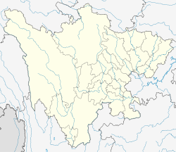
 Panzhihua
Coordinates: 26°35′N 101°43′E / 26.583°N 101.717°ECoordinates: 26°35′N 101°43′E / 26.583°N 101.717°E Country China Province Sichuan City seat Dongqu (东区) Area – Total 7,440.398 km2 (2,872.8 sq mi) Elevation 1,157 m (3,796 ft) Population – Total 1,100,800 – Density 147.9/km2 (383.2/sq mi) Time zone China Standard (UTC+8) Postal code 617000 Area code(s) 0812 Website http://www.pzhs.gov.cn/ Panzhihua (Chinese: 攀枝花; pinyin: Pānzhīhūa; Wade–Giles: P'an-chih-hua) is a prefecture-level city located in the far south of Sichuan province of Southwest China, on the confluence of the Jinsha and Yalong Rivers. It has an administrative area of 7,440.398 square kilometres (2,872.754 sq mi),[1] and a total population of 1,100,800 as of 2007.[2] It is the only city in China having a name of a flower, and its economy relies almost entirely on its giant mine, one of the biggest in China. The latter makes it a very polluted city, where the air condition is quite poor.
Contents
Geography and climate
Panzhihua is a treasure of natural resources, but remained a wasteland until 1960. It was founded on a remote headwater of the Yangtze River in 1966 as a steel production center. It grew rapidly as it remained relatively prosperous while the rest of the country was undergoing the Cultural Revolution. The city is home to the Panzhihua Iron and Steel (Group) Co, called "Pangang 攀钢", the leading steel company in southwest China. There remains a remnant population of the ancient cycad forests which were once home to the giant panda.
The area has a monsoon-influenced humid subtropical climate (Köppen Cwa), with short, mild (almost warm), very dry winters, and long, hot, and humid summers. Highs drop to 21 °C (70 °F) in December and January, quickly rebounding during the dry springs, and peak in May and June, unlike much of the rest of the province. Much of the annual rainfall occurs from June to September.
Climate data for Panzhihua (1988−2007) Month Jan Feb Mar Apr May Jun Jul Aug Sep Oct Nov Dec Year Average high °C (°F) 21.8
(71.2)24.8
(76.6)28.6
(83.5)31.7
(89.1)32.3
(90.1)32.2
(90.0)31.0
(87.8)30.6
(87.1)28.1
(82.6)26.2
(79.2)23.4
(74.1)21.0
(69.8)27.6 Average low °C (°F) 6.9
(44.4)9.9
(49.8)14.2
(57.6)17.7
(63.9)19.8
(67.6)21.4
(70.5)21.3
(70.3)20.8
(69.4)18.9
(66.0)16.2
(61.2)11.3
(52.3)7.2
(45.0)15.5 Rainfall mm (inches) 5.5
(0.217)3.7
(0.146)8.2
(0.323)14.0
(0.551)57.9
(2.28)144.0
(5.669)221.1
(8.705)188.2
(7.409)139.2
(5.48)57.7
(2.272)16.9
(0.665)1.9
(0.075)858.3
(33.791)Source: 中央气象台 Geology
Panzhihua is close to Xigeda-Yuanmou fracture in the Sichuan-Yunnan border.[3] Its Renhe District was the epicenter of the 2008 Panzhihua earthquake.
Administrative divisions
Map 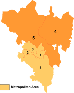
# Name Hanzi Hanyu Pinyin Population (2004 est.) Area (km²) Density (/km²) 1 Dong District 东区 Dōng Qū 320,000 167 1,916 2 Xi District 西区 Xī Qū 160,000 124 1,290 3 Renhe District 仁和区 Rénhé Qū 200,000 1,727 116 4 Miyi County 米易县 Mǐyì Xiàn 200,000 2,153 93 5 Yanbian County 盐边县 Yánbiān Xiàn 200,000 3,269 61 Transport
Panzhihua is a highly industrialized area, which is dominated by a truly gigantic mining operation. Most of the land not in use for mining is taken up by subsistence farming.
Panzhihua is linked to Chengdu and Kunming by rail.
With Panzhihua Airport, Panzhihua is also linked by Air to Chengdu.
Education
- Panzhihua University
- The city's top high schools are the No.3 Panzhihua high school (located downtown) and the no.7 high school (located in the western district (Qinxiangping))
References
- ^ "Nature Resources of Panzhihua" (in Chinese). Official website of Panzhihua Government. http://www.pzhs.gov.cn/zjpzh/zrgk/zrzy/index.shtml. Retrieved 2008-08-30.
- ^ "Demographics of Panzhihua" (in Simplified Chinese). Official website of Panzhihua Government. http://www.pzhs.gov.cn/zjpzh/zrgk/rktj/index.shtml. Retrieved 2008-08-30.
- ^ "Roughly: Part III of emergency response to the M6.1 earthquake at the border of Renhe-Huili, Sichuan: Seismic formation background. (四川攀枝花市仁和区-凉山州会理县交界6.1级地震现场应急工作系列报道之三地震构造背景)" (in Chinese). China Earthquake Administration, CEA (中国地震局门户网). 2008-09-02. http://www.cea.gov.cn/manage/html/8a8587881632fa5c0116674a018300cf/_content/08_09/02/1220328119176.html. Retrieved 2008-09-07.
External links
Sichuan Province county-level divisions Chengdu: Qingyang District · Jinjiang District · Jinniu District · Wuhou District · Chenghua District · Longquanyi District · Qingbaijiang District · Xindu District · Wenjiang District · Dujiangyan City · Pengzhou City · Qionglai City · Chongzhou City · Jintang County · Shuangliu County · Pi County · Dayi County · Pujiang County · Xinjin County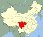 Sichuan in China
Zigong: Ziliujing District · Da'an District · Gongjing District · Yantan District · Rong County · Fushun County
Panzhihua: Dongqu District · Xiqu District · Renhe District · Miyi County · Yanbian County
Luzhou: Jiangyang District · Naxi District · Longmatan District · Lu County · Hejiang County · Xuyong County · Gulin County
Deyang: Jingyang District · Shifang City · Guanghan City · Mianzhu City · Luojiang County · Zhongjiang County
Mianyang: Fucheng District · Youxian District · Jiangyou City · Santai County · Yanting County · An County · Zitong County · Pingwu County · Beichuan Autonomous County
Guangyuan: Lizhou District · Yuanba District · Chaotian District · Wangcang County · Qingchuan County · Jiange County · Cangxi County
Suining: Chuanshan District · Anju District · Pengxi County · Shehong County · Daying County
Neijiang: Shizhong District · Dongxing District · Weiyuan County · Zizhong County · Longchang County
Leshan: Shizhong District · Shawan District · Wutongqiao District · Jinkouhe District · Emeishan City · Qianwei County · Jingyan County · Jiajiang County · Muchuan County · Ebian Autonomous County · Mabian Autonomous County
Nanchong: Shunqing District · Gaoping District · Jialing District · Langzhong City · Nanbu County · Xichong County · Yingshan County · Yilong County · Peng'an County
Meishan: Dongpo District · Renshou County · Pengshan County · Hongya County · Danleng County · Qingshen County
Yibin: Cuiping District · Yibin County · Nanxi County · Jiang'an County · Changning County · Gao County · Junlian County · Gong County · Xingwen County · Pingshan County
Guang'an: Guang'an District · Huaying City · Yuechi County · Wusheng County · Linshui County
Dazhou: Tongchuan District · Wanyuan City · Da County · Xuanhan County · Kaijiang County · Dazhu County · Qu County
Ya'an: Yucheng District · Mingshan County · Yingjing County · Hanyuan County · Shimian County · Tianquan County · Lushan County · Baoxing County
Bazhong: Bazhou District · Tongjiang County · Nanjiang County · Pingchang County
Ziyang: Yanjiang District · Jianyang City · Lezhi County · Anyue County
Ngawa: Barkam County · Wenchuan County · Li County · Mao County · Songpan County · Jiuzhaigou County · Jinchuan County · Xiaojin County · Heishui County · Zamtang County · Ngawa County · Zoigê County · Hongyuan County
Garzê: Luding County · Danba County · Jiulong County · Yajiang County · Dawu County · Luhuo County · Garzê County · Xinlong County · Dêgê County · Baiyü County · Sêrxü County · Sêrtar County · Litang County · Batang County · Xiangcheng County · Daocheng County · Dêrong County
Liangshan: Xichang City · Yanyuan County · Dechang County · Huili County · Huidong County · Ningnan County · Puge County · Butuo County · Jinyang County · Zhaojue County · Xide County · Mianning County · Yuexi County · Ganluo County · Meigu County · Leibo County · Muli Autonomous CountyCategories:- Populated places in Sichuan
- Populated places on the Yangtze River


Wikimedia Foundation. 2010.