- May 2003 tornado outbreak sequence
-
May 2003 tornado outbreak sequence Date of tornado outbreak: April 30–May 11, 2003 Duration1: 12 days Maximum rated tornado2: F4 tornado Tornadoes caused: 401 confirmed (most ever in an outbreak sequence) Damages: $952 million (2005 USD)[1] Fatalities: 48+ Areas affected: Most of the central and eastern continental United States and southern Ontario 1Time from first tornado to last tornado
2Most severe tornado damage; see Fujita ScaleThe May 2003 tornado outbreak sequence in the United States was a series of tornado outbreaks that occurred from May 3 to May 11, 2003. Tornadoes began occurring over the affected area on April 30, but the most prolific continuous period was the seven day period of May 4–10. There were 401 tornado reports in 19 states and 1 Canadian province, 1,587 reports of large hail, and 740 reports of wind damage.[2] More severe weather broke out this week alone than any other week in U.S. history.[2] The old record for most tornado reports in one week was 171 during the week of the May 1995 Tornado Outbreak Sequence (May 12 to May 18, 1995).[3] The Super Outbreak of April 3 to April 4, 1974, previously held the record for the most tornadoes produced in a 24 hour period until that record was surpassed by the 2011 Super Outbreak which produced approximately 190 tornadoes in a 24 hour period. The Super Outbreak in April 1974 also produced more significant and violent tornadoes than any other week in history.[4]
Meteorological synopsis
The main meteorological factor for this series of tornado outbreaks was the presence of a persistent 500 mb trough over the western United States, coupled with a series of shortwave disturbances which propagated through the central and eastern United States. These shortwaves provided a mechanism for the deepening of surface low pressure areas, which followed the upper level flow from southwest to northeast. The cyclones induced a strong north to southeasterly flow in the low levels of the atmosphere (1000 mb, 850 mb) off the Gulf of Mexico. This persistent flow provided an abundance of warm, moist maritime tropical air in the central and eastern US.
The interaction between warm, dry air from the western United States and the moist Gulf airmass resulted in a boundary known as the dry line. This boundary, along with other factors provided a source of lift promoting thunderstorm development. CAPE describes the instability in the atmosphere and the tendency for it to rise; high CAPE values are usually associated with severe weather. CAPE values during the period of April 30 - May 11 were extremely high in the affected areas. A strong, persistent southeast to northwest upper level flow contributed to wind shear, and induced strong rotation in many of the thunderstorms that developed. These rotating thunderstorms, or supercells, are capable of spawning tornadoes.
Total confirmed tornadoes
Main article: List of May 2003 tornado outbreak sequence tornadoesConfirmed
TotalConfirmed
F0Confirmed
F1Confirmed
F2Confirmed
F3Confirmed
F4Confirmed
F5401 213 123 39 20 6 0 April 30 event
Confirmed tornadoes
Confirmed
TotalConfirmed
F0Confirmed
F1Confirmed
F2Confirmed
F3Confirmed
F4Confirmed
F521 18 3 0 0 0 0 May 1 event
Confirmed tornadoes
Confirmed
TotalConfirmed
F0Confirmed
F1Confirmed
F2Confirmed
F3Confirmed
F4Confirmed
F514 8 4 2 0 0 0 May 2 event
Confirmed tornadoes
Confirmed
TotalConfirmed
F0Confirmed
F1Confirmed
F2Confirmed
F3Confirmed
F4Confirmed
F51 0 1 0 0 0 0 May 3 event
Confirmed tornadoes
Confirmed
TotalConfirmed
F0Confirmed
F1Confirmed
F2Confirmed
F3Confirmed
F4Confirmed
F514 11 2 1 0 0 0 May 4 event
 May 4, 2003 Tornado Tracks
Most prolific day of the sequence
The meteorological ingredients that made conditions favorable for devastating severe weather came together early in the day on May 4. One of the 500 mb shortwaves that had propagated from the Rocky Mountains into the central plain states had induced the deepening of a 990 mb low over northwestern Missouri. A warm front extended from this low through Missouri, Arkansas, and Tennessee. South of this front, southerly winds at the surface had advected unseasonably warm, moist air from the Gulf of Mexico into the Mississippi Valley and surrounding states. Temperatures reached the mid 80s(°F) and dew points had risen above 70 °F (21 °C).
In the upper levels of the atmosphere, the left exit region of a 250 mb jet streak had been positioned over the affected area, providing enhanced lift. This in combination with low level instability contributed to explosive thunderstorm development. Winds at the 850 mb level were enhanced as the day progressed, and velocity maxima exceeded 70 kts by 0300 UTC.
The thunderstorms that developed in the region quickly began rotating, due to the enhanced environmental wind shear. Long-lived supercells were prevalent; many of which produced families of strong to violent, long-tracked tornadoes. Kansas, Missouri, Arkansas, and Tennessee were hardest hit. A total of 86 tornadoes touched down, making May 4, 2003 one of the largest single-day outbreaks in history. Thirty-eight people were killed, and nearly 400 injured by the twisters.
Confirmed tornadoes
Confirmed
TotalConfirmed
F0Confirmed
F1Confirmed
F2Confirmed
F3Confirmed
F4Confirmed
F586 32 29 13 8 4 0 Southwest Missouri/Southeast Kansas tornadoes
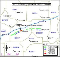
 Tornado Tracks in Southwest Missouri
Franklin Tornado (F4)
A large tornado touched down in Neosho County, Kansas at 4:32 pm on May 4. The tornado was initially about 250 yards (230 m) wide and produced F2 damage as it crossed into Crawford County. Aerial damage surveys indicate an increase in width and intensification as the tornado approached the community of Ringo (5 miles (8 km) east of Girard), in Crawford County. Dramatic scouring of the ground was observed, and heavy objects such as vehicles were tossed long distances (over 100 yards (91 m)). The NWS described the damage in this portion of the track as "high-end F4". As it barreled past Ringo and entered the unincorporated town of Franklin (5 miles (8 km) north of Frontenac), the path reached over 1⁄2 miles (0.8 km) wide at points. Franklin was all but destroyed. Numerous buildings and homes were demolished and three deaths were reported, along with approximately 20 injuries. The tornado continued producing "high end F4" damage as it passed the town of Mulberry, where a train was derailed from the winds of the storm, and crossed into Barton County, Missouri. In Missouri, the twister demolished several farm houses, killing an 88-year-old man. Its path began to narrow several miles into Missouri; video and eyewitness accounts suggest that the tornado was "roping out". It finally lifted to the north of Liberal, Missouri after having traveled for approximately 35 miles (56 km). Almost immediately after the Franklin tornado lifted, a second large tornado was reported to have touched down on the east side of Liberal.
 Tornado near Franklin
 The Tornado Intensifies
Stockton tornado (F3)
The second major tornado produced by the Franklin supercell was initially observed to the east of Liberal (5:31 pm). Analysis indicated a 1⁄2 miles (0.8 km) wide damage path through rural portions of Barton County, Missouri. Several structures received F1 to F2 damage. The tornado crossed into Cedar County and continued producing high end F2/low end F3 damage. One man was killed east of Liberal when his home was destroyed. As it approached the town of Stockton, several framed houses were swept off their foundations. Structural analysis indicated poor anchoring of the homes, thus warranting a high end F3 rating. The funnel then proceeded travel through the center of Stockton causing considerable devastation, and killing three. The tornado was approximately 3⁄4 miles (1.2 km) in diameter as it left Stockton. A two-story framed home to the east of Stockton was almost entirely destroyed, and several vehicles were tossed hundreds of feet (also high end F3). Also, almost all the buildings on the "square" of Stockton were destroyed, and the only thing left was the vault from the bank. The roof was torn off of most of the Stockton school, but the court house, just 1⁄8 miles (0.2 km) south of the square only took minor damage. The city was closed off to the public for nearly two days. The tornado crossed into northern Polk County, and appeared to have weakened slightly. A handful of structures received F1 and F2 damage. Continuing all the way through Polk County, it shrank to approximately 300 yards (274 m) in diameter as it entered Dallas County. Damage analysis indicated twin funnels in western Polk (another tornado touched down just to the south of the parent funnel) (Observers did confirm twin tornadoes on the ground near Humansville, Missouri in northwest polk county). Over 48 homes were destroyed in northern Dallas county (again F3 damage), and two additional fatalities occurred. South of Tunas, its track shifted form northeasterly to almost east-southeasterly. It then proceeded to abruptly weaken and dissipate. The Stockton tornado had traveled for 86 miles (138 km) miles, across four counties in their entirety. One year after the tornado hit a plaque was placed at the town park in honor of the three men who lost their lives.
Camden County tornado (F3)
Yet another tornado touched down in Camden county, Missouri, several minutes after the Stockton tornado dissipated (731 PM). This tornado quickly grew to 400 yards in diameter, and destroyed 50 homes near Camdenton. Two homes (considered to have been well anchored) were swept free short distances from their foundations. 4 fatalities were reported in the Camdenton area. The tornado then moved northeast and dissipated near Montreal. Its path length was 15 miles.
Carl Junction tornado (F3)
Weather spotters reported a funnel that may have touched down briefly several times in western Cherokee County. The first observable damage was observed to the north of Melrose. It initially produced minimal F0 and F1 damage. One death occurred south of Columbus, where the tornado produced some F2 damage to several structures. It widened and intensified as it approached the Kansas/Missouri border; several homes were almost entirely destroyed and numerous structures were severely damaged. A couple was killed in their home by flying debris in this area. The now 1/2 mile wide tornado crossed into Jasper county Missouri and raged through the center of Carl Junction. More than 500 structures were damaged or destroyed and 2 additional deaths occurred. F2 to F3 damage was observed in Carl Junction. The storm then veered north and dissipated, moving just north of Oronogo. It had traveled approximately 25 miles.
Pierce City tornado (F3)
A second supercell south of the storm that spawned the Franklin/Stockton/Camdenton tornadoes produced several funnel clouds through Newton county before any tornado touchdown was reported. Damage was first observed south of Ritchey, in Newton county. Several structures were moderately damaged. The most significant damage in Newton county was rated F2. The tornado reached over 1/2 mile wide as it crossed into Lawrence county, and abruptly strengthened to an F3 as it entered the town of Pierce City. Pierce City was devastated. Nearly every structure was either damaged or destroyed (including several buildings of historical significance). 5 people were killed, many of whom died in mobile homes. The tornado continued through Lawrence county and on into Christian county, barely missing several large population centers. In Christian county, dozens of structures were damaged and one fatality was reported. Damage here ranged between high end F2 and F3. After passing Clever, the path veered north into Greene county (toward Springfield). 100 homes were destroyed in the Springfield suburb of Battlefield. One fatality was also reported here. The damage path abruptly ended several miles past Battlefield, just before the tornado would have entered Springfield. NWS gave this tornado an F3 rating overall. It traveled just shy of 50 miles, across 4 counties.
Kansas City tornado family
 Tornado Tracks in Kansas City Area
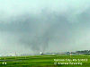 The Kansas City Tornado
Linwood tornado (F2)
The first tornado of the Kansas City storm touched to the Northwest of Linwood, just South of the Kansas Turnpike. It initially produced F1 damage as it crossed the Turnpike, and was reported to have been approximately 250 yards wide. Notable F2 damage was observed near the intersection of 166th and Kansas Avenue. Numerous homes and buildings were damaged, and 2 injuries were reported. The tornado lifted just to the south of Basehor. It had traveled just over 6 miles.
North Kansas City tornado (F4)
Several minutes after the first tornado dissipated, a second larger funnel touched down Northwest of Bonner Springs. It initially produced light damage (F0 to F1); however, 2 homes were almost destroyed near I-435, indicating F3 damage. The tornado grew to nearly 500 yards in diameter as it passed through Northern Kansas City, Kansas, and a few well constructed homes were leveled near 91st and Leavenworth Road. NWS rated this portion of the track low-end F4. The only two fatalities attributed to the storm occurred here. To the northeast persistent F2 and F3 damage was observed through 84th street. In the vicinity of 79th Street and Cernech additional F4 damage was produced. Several structures were demolished, and metal power poles engineered to withstand 200 mph winds were tossed to the ground. The tornado then crossed the Missouri River into Platte County, Missouri. The path width decreased and high end F1 damage was observed for the remainder of the tornado's track. It dissipated just to the south of Gladstone, after having traveled for 21 miles.
 Another image of the Kansas City Tornado
 Damage from the Gladstone Tornado via NOAA
Gladstone tornado (F4)
The third tornado touched down in Gladstone (reportedly as a new circulation developed in the thunderstorm). Like the others, it was initially weak (F1), but quickly strengthened and widened to approximately 300 yards in diameter. Near the intersection of NE 63rd Terrace and N Jackson, marginal F4 was produced. Just to the Northeast of this location, NWS noted an additional pocket of F4 damage. The tornado continued producing F2 to F3 damage before dissipating, after having traveled for only 5 miles.
Liberty tornado (F2)
The fourth and final tornado of the Kansas City Supercell touched down in Liberty, Missouri around 5 p.m. Substantial damage occurred on the downtown square, into William Jewell College (high end F2) and continued tracking east along Route H into unincorporated Clay County. The total track length was 8 miles. The funnel was reported to have been 200 to 300 yards in diameter, though photographs suggest that it may have been somewhat larger. It continued tracking east along Route H into Clay County, and then lifted. The total track length was 8 miles.
Jackson, Tennessee area tornadoes
 Jackson Area Tornado Tracks
Jackson tornado #1 (F4)
A large tornado touched down in southwest Madison County, TN after dark. It was initially 200 to 300 yards in diameter; however, rapid intensification occurred as the funnel approached Jackson. The now 1/2 mile wide tornado plowed through downtown Jackson and damaged or destroyed hundreds of buildings and homes. Several structures were leveled, warranting an F4 rating. 66 people were injured and 11 fatalities were reported, most of which occurred downtown. The tornado continued into Henderson county, though aerial damage surveys indicate significant weakening occurred just to the east of Jackson. Sporadic F0 to F1 damage was observed for the remainder of the tornado's path. It lifted just to the west of Lexington, after having traveled for an impressive 39 miles.
Jackson tornado #2 (F3)
The second Jackson area tornado touched down to the south of the initial track. It was reported to have been up to 1/4 mile wide, and produced F1 damage to the southwest of Jackson. The tornado then moved south of the Jackson City limits, destroying several homes and businesses. The damage in this area was rated by NWS officials to be F2 to F3. The track became sporadic and narrow as the tornado crossed from Madison county to Henderson county, and damage surveys indicated that the tornado dissipated to the south of Lexington. The total path length was 21 miles.
May 5 event
Confirmed tornadoes
Confirmed
TotalConfirmed
F0Confirmed
F1Confirmed
F2Confirmed
F3Confirmed
F4Confirmed
F522 15 6 0 1 0 0 May 6 event
Confirmed tornadoes
Confirmed
TotalConfirmed
F0Confirmed
F1Confirmed
F2Confirmed
F3Confirmed
F4Confirmed
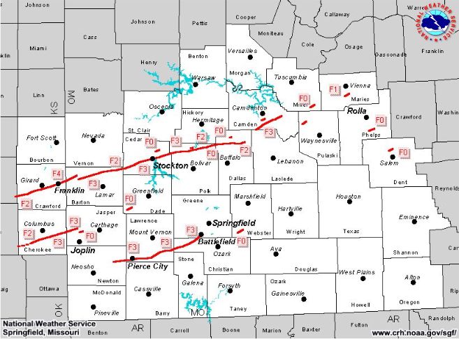
F575 41 27 5 1 1 0 Paducah area tornadoes
Jackson Missouri tornado (F3)
At approximately 845 PM, a small tornado touched down in Jackson, Missouri. The tornado initially tore the roof off the town police station and the fire department, which share the same structure. It also damaged the roof of a pottery factory, destroyed a local bakery, and destroyed the gymnasium of a local Catholic elementary school, with some walls partially remaining. It passed directly through downtown Jackson with a width of about 50 yards, tossing vehicles and uprooting trees. Roofs were torn from many structures as well. Just outside of downtown several homes were destroyed, with only a few interior walls remaining (F3 damage). Many other homes in this area were severely damaged. The tornado lifted to the northeast of Jackson, after having traveled for just over 2 miles. Only two injuries were reported.
Massac County tornado (F4)
A very large tornado touched down in Pulaski County, IL at approximately 932 PM. The funnel was estimated to have been 2/3 of a mile in diameter as it moved into Massac County, blowing a few framed homes off their foundations, and severely damaging others. A mobile home was literally wrapped around a tree and its occupant killed. Another fatality occurred in an unanchored home as it was destroyed. Damage in eastern Massac County was consistent with F4 intensity. Many structures were also severely damaged even further east in the Mermet Lake Conservation Area. Many vehicles were lifted, rolled, or thrown 100 yards or more; glass was impaled into trees; some trees were either debarked or uprooted. The tornado continued into northern Pope county before it dissipated at 1042PM. The path length was 33 miles.
May 7 event
Confirmed tornadoes
Confirmed
TotalConfirmed
F0Confirmed
F1Confirmed
F2Confirmed
F3Confirmed
F4Confirmed
F531 16 11 4 0 0 0 May 8 event
Confirmed tornadoes
Confirmed
TotalConfirmed
F0Confirmed
F1Confirmed
F2Confirmed
F3Confirmed
F4Confirmed
F542 26 9 3 3 1 0 Northeast Kansas tornadoes
Lawrence tornado (F2)
In the evening hours of May 8, a tornado warning was issued for Douglas County, Kansas for a supercell storm that produced a tornado in nearby Osage County. As the tornado tracked across Douglas County, it mushroomed into a 400-yard wide vortex, as reported by one storm chaser. By the time it reached Lawrence, the tornado had weakened and shrunk in size, but it was still strong enough to cause F1-F2 damage in the southwest part of town.
Central Oklahoma tornadoes
Moore Tornado (F4)
 Radar shot of the Moore/Oklahoma City supercell at its peak intensity in southeastern OKC
Four years after an F5 tornado destroyed large sections of Moore during the 1999 Oklahoma tornado outbreak, another strong tornado affected the area. The storm responsible for the Moore tornado developed across Grady County during the mid-afternoon hours and produced a weak tornado near Newcastle and west of Moore. Just after 5:00 PM, a new tornado touched down on the west side of Moore west of Interstate 35 and moved east northeast across Moore, then the southeastern sections of Oklahoma City including Tinker Air Force Base near Interstate 40, Midwest City and Choctaw.[5] As the tornado passed through the Moore area, a tornado emergency was issued for eastern Oklahoma County. Despite extensive damage all along the path, no fatalities were caused by the tornado although dozens of injuries were reported across Cleveland and Oklahoma Counties.
 Extensive damage was widespread across the southeastern Oklahoma City metro area
Damage across Moore was rated as high as a high-end F3 near 12th Street where several businesses, two hotels, an office building, a church, several restaurants, a child center and a Headstart Program building were either severely damaged or destroyed. It also damaged numerous homes in the Highland Park subdivision which was mostly destroyed by the F5 tornado which passed just a few block north of the May 8, 2003 tornado. Other homes on the north side of the city also sustained significant damage before crossing the Cleveland-Oklahoma county line.[6]
In the Oklahoma City area, the General Motors Assembly Plant sustained major damage as well as a manufacturing plant near Interstate 240 were F4 damage was observed. Several other businesses were either damaged or destroyed. At Tinker Air Force Base, a storage bunker and several fences were damaged. Several subdivisions in eastern Oklahoma City, Choctaw and Midwest City were also affected by the tornado with several homes sustaining significant damage.[6]
May 9 Event
Confirmed tornadoes
Confirmed
TotalConfirmed
F0Confirmed
F1Confirmed
F2Confirmed
F3Confirmed
F4Confirmed
F533 19 12 1 1 0 0 Central Oklahoma - round two
One supercell across central Oklahoma produced 10 tornadoes from Caddo to Creek Counties during the evening hours of May 9, 2003. The most significant tornado affected northeastern sections of Oklahoma County from Interstate 35 and areas along Interstate 44 to near Luther.
 Severe damage to a home in Oklahoma County
The supercell developed across Greer County during the early evening and slowly moved east/northeast and started to produced tornadoes in Caddo County at around 9:00 PM. As it approached Interstate 40 near Bethany the National Weather Service issued a tornado emergency citing that the radar was detecting a potentially large and violent tornado in the area. Two tornadoes in Bethany and Warr Acres rated F1 produced minor to moderate damage mostly to trees but several structures were also damaged including churches, a storage facility, car ports, airports hangars at the Wiley Post Airport, several homes, warehouses and businesses. 8 were injured in the Bethany tornado and damage was pegged at $10 million.
Just after 10:30 PM, a large tornado touched down northwest of the Interstate 35 and Interstate 44 interchange in northeastern Oklahoma City near KWTV and KOCB stations.[7] The tornado was filmed live by KFOR-TV helicopter reporter Jim Gardner near I-35 at Britton Road northeast of the station of the NBC affiliate and large power flashes were seen from the air during live severe weather coverage. The National Weather Service issued another tornado emergency for that particular tornado. Moving parallel along the Turner Turnpike, the tornado produced its worst damage just east of I-35/44 where damage to an industrial building and a horse ranching operation was rated F3. Additionally, the tornado damaged several homes and barns in northeast Oklahoma City and Oklahoma County with one home destroyed. Tornado damage estimates were about $7 million. The tornado lifted shortly after 11:00 PM. Despite extensive damage, only 2 people were injured as mostly of the tornado track was over sparsely populated areas and also near Interstate 44 where there were few structures. Additional tornadoes touched down until after midnight and numerous structures in Davenport and Stroud in Lincoln County sustained significant damage shortly before midnight. No fatalities were reported in Oklahoma during the outbreak.
May 10 Event
Confirmed tornadoes
Confirmed
TotalConfirmed
F0Confirmed
F1Confirmed
F2Confirmed
F3Confirmed
F4Confirmed
F560 25 19 10 6 0 0 May 11 Event
Confirmed tornadoes
Confirmed
TotalConfirmed
F0Confirmed
F1Confirmed
F2Confirmed
F3Confirmed
F4Confirmed
F53 2 1 0 0 0 0 2003 tornado season in perspective
Outbreak death toll State Total County County
totalIllinois 2 Massac 1 Pulaski 1 Kansas 8 Cherokee 3 Crawford 3 Wyandotte 2 Kentucky 1 Mercer 1 Missouri 19 Barton 1 Camden 4 Cedar 3 Christian 1 Dallas 2 Greene 1 Jasper 2 Lawrence 5 Tennessee 11 Madison 11 Totals 41 All deaths were tornado-related The 2003 tornado season had been relatively slow up until May 1. In fact, around May 1 through July 1 was the most active time of the year in tornadoes. The first tornado report of the year came on February 15. About 400 tornadoes were reported during the first 10 days of May, more than 500 were reported during the entire month.
See also
Notes
- ^ http://www4.ncdc.noaa.gov/cgi-win/wwcgi.dll?wwevent~storms
- ^ a b "May 2003 Tornado Outbreak Sequence". Science Daily. http://www.sciencedaily.com/articles/m/may_2003_tornado_outbreak_sequence.htm. Retrieved 2008-06-02.
- ^ "RECORD NUMBER OF TORNADOES, NOAA REPORTS". NOAA. May 13, 2003. http://www.noaanews.noaa.gov/stories/s1144.htm. Retrieved 2007-07-10.
- ^ Schneider, Russell; H.E. Brooks, and J.T. Schaefer (October 2004). "Tornado Outbreak Day Sequences: historic events and climatology (1875-2003)". 22nd Conference on Severe Local Storms. Hyannis, MA: American Meteorological Society. http://ams.confex.com/ams/11aram22sls/techprogram/paper_81933.htm.
- ^ "Fast Facts about the May 8, 2003 Oklahoma City Tornado". National Weather Service. http://www.srh.noaa.gov/oun/?n=events-20030508. Retrieved 2008-06-02.
- ^ a b "Preliminary Damage Survey Results from the May 8, 2003 Moore-OKC Area Tornado, Part II". National Weather Service. http://www.srh.noaa.gov/oun/?n=events-20030508. Retrieved 2008-06-02.
- ^ NCDC: Event Details
References
- (2004). Studies of the May 2003 tornado outbreaks, Session 12, 22nd Conference on Severe Local Storms, American Meteorological Society.
External links
- Overall
- May 2003 Tornado Statistics (SPC, NOAA)
- NWS Service Assessment
- Working_Together_to_Save_Lives:
Early_May_Delivers_Nations_Busiest_Tornado_Outbreak_in_Many_Years Early May Delivers Nation's Busiest Tornado Outbreak in Many Years (NOAA's NWS Focus) - NCDC Billion Dollar U.S. Weather Disasters Summary
- May 2003 Tornado Outbreak (Climate Diagnostics Center)
- Tornado Outbreak Day Sequences: Historic Events and Climatology (1875-2003) (Russell S. Schneider, Harold E. Brooks, and Joseph T. Schaefer, American Meteorological Society)
- May 2003 Events (NWS Little Rock, AR)
- Memphis National Weather Service Perspective of the Severe Weather Outbreak of May 2003 - Focus on the F4 Madison County, Tennessee Tornado (NWS Memphis, TN)
- OK-FIRST Case Study: The Tornado Outbreaks of May 2003
- Worst Week Ever For Twisters (CBS News)
- NOAA: Cold Front Spawns Super-Cell Storms, Deadly Tornadoes in Central Plains States
- April 30 - May 3
- National weather service storm survey results for April 30, 2003 (NWS Quad Cities, IA/IL)
- Severe Weather May 1-3, 2003 (NWS Little Rock, AR)
- May 4–5
- Severe Weather Event - May 4, 2003 (NWS Kansas City, MO)
- Tornadoes Rip Across Southeast Kansas and the Missouri Ozarks May 4th 2003 (NWS Springfield, MO)
- Severe Weather May 4-5, 2003 (Little Rock, AR)
- May 4-7 2003 Mid-South Severe Weather (NWS Memphis, TN)
- Summary of the May 4-5, 2003 Middle Tennessee Tornadoes (NWS Nashville, TN)
- Cold Front Spawns Supercell Storms, Deadly Tornadoes in Central Plains States (NOAA News)
- May 4, 2003 Severe Weather Outbreak (Midwestern Regional Climate Center)
- Pierce City Rebuilds (USA Today)
- Kansas City, KS May 4, 2003 "The 5-4-3 Tornado Outbreak" - Images and videos of the Kansas City Tornadoes
- 5-04-03 Kansas City, Missouri Chase - Twister Sister images of the Kansas City Tornadoes
- May 6–7
- May 6, 2003 Tornado Outbreak (NWS Paducah, KY)
- May 6-8, 2003 (NWS Little Rock, AR)
- White Plains Tornado. March 6, 2003 (NWS Birmingham, AL)
- Severe Weather & Flooding of May 7, 2003 (NWS Birmingham, AL)
- May 8
- May 8, 2003: Central Oklahoma Tornadoes (NWS Norman, OK)
- Perry and Breckinridge Counties, KY Tornado Damage (NWS Louisville, KY)
- May 9
- May 9, 2003: Central Oklahoma Tornadoes (NWS Norman, OK)
- May 10
- Central Illinois Tornadoes on May 10, 2003 (NWS Central Illinois)
- Radar Images from May 10, 2003 (NWS Central Illinois)
- Storm Survey Results for the May 10, 2003 Event (NWS Quad Cities, IA/IL)
- The Tornadoes of May 10, 2003 (NWS St. Louis)
- Preliminary Storm Survey Results for the May 10, 2003 Event (NWS Quad Cities, IA/IL)
- Lafayette and Iowa County Tornadoes (NWS Milwaukee, WI)
- 5th Anniversary document of the May 10 tornado outbreak (NWS St. Louis, MO)
- May 11
- Mercer County, KY Tornado Damage (NWS Louisville, KY)
- Hart County, KY Tornado Damage (NWS Louisville, KY)
- Hardin County, KY Tornado Damage (NWS Louisville, KY)
- Summary of the May 11, 2003 Middle Tennessee Tornadoes (NWS Nashville, TN)
Categories:- F4 tornadoes
- Tornadoes of 2003
- Tornadoes in Alabama
- Tornadoes in Arkansas
- Tornadoes in Colorado
- Tornadoes in Georgia (U.S. state)
- Tornadoes in Illinois
- Tornadoes in Kansas
- Tornadoes in Kentucky
- Tornadoes in Mississippi
- Tornadoes in Missouri
- Tornadoes in Oklahoma
- Tornadoes in Tennessee
- 2003 natural disasters in the United States


Wikimedia Foundation. 2010.