- Namtso
-
Namtso 
View on the lake and the holy rock near the Tashi Dor monastery (2005) 
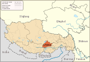
Relief map. Lhasa is the red marked area at the bottom. Location Damxung/Baingoin, Tibet, China Coordinates 30°42′N 90°33′E / 30.7°N 90.55°ECoordinates: 30°42′N 90°33′E / 30.7°N 90.55°E Lake type salt lake Primary inflows snow cover and spring of Tanggula mountains Primary outflows Salween River Basin countries China Max. length 70 kilometer Max. width 30 kilometer Surface area 1,920 km2 (740 sq mi) Average depth 33 meter Max. depth 125 m (410 ft)[1] Water volume 768 billion cubic meter Surface elevation 4,718 m (15,479 ft) Islands 5 Namtso Tibetan name Tibetan: གནམ་མཚོ་ Wylie transliteration: gnam mtsho pronunciation in IPA: [namtsʰo] official transcription (PRC): Nam Co THDL: Namtso other transcriptions: Namtsho, Namco Chinese name traditional: 納木錯 simplified: 纳木错 Pinyin: Nàmù Cuò Namtso or Lake Nam (officially: Nam Co; Mongolian: Tengri Nor; “Heavenly Lake”; 30°42′N 90°33′E / 30.7°N 90.55°E) is a mountain lake on the border between Damxung County of Lhasa Prefecture and Baingoin County of Nagqu Prefecture in the Tibet Autonomous Region of China, approximately 112 kilometres (70 mi) NNW of Lhasa.
Contents
Geography and climate
Namtso was born Paleogene age, result of Himalayan tectonic plate movements. The lake lies at an elevation of 4,718 m, and has a surface area of 1,920 square kilometres. This salt lake is the largest lake in the Tibet Autonomous Region. However, it is not the largest lake in the Qinghai-Tibet Plateau. That title belongs to Qinghai Lake (more than twice the size of Namtso); which lies more than 1,000 km [650 miles] to the north-east, in China's Qinghai province.
Namtso has five uninhabited islands of reasonable size, in addition to one or two rocky outcrops. The islands have been used for spiritual retreat by pilgrims who walk over the lake's frozen surface at the end of winter, carrying their food with them. They spend the summer there, unable to return to shore again until the water freezes the following winter. This practice is no longer permitted by the Chinese Government.
The largest of the islands is in the north-west corner of the lake, and is about 2,100 m long and 800 m wide, rising to just over 100 m in the middle. At its closest point it is about 3.1 km from the shore.
The most remote island is, at its closest, 5.1 km from the shore. At summer time birds like Ruddy shelduck Phalacrocorax migrate to the lake area, besides the filed of astragalus, roegneria nutans and marram grass.
The weather at Namtso is subject to abrupt sudden change and snowstorms are very common across the Nyainqêntanglha range.
Other Features
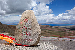
Namtso is renowned as one of the most beautiful places in the Nyainqêntanglha mountain range. Its cave hermitages have for centuries been the destination of Tibetan pilgrims. A surfaced road across Laken Pass at 5186 m was completed to the lake in 2005, enabling easy access from Lhasa and the development of tourism at the lake.
 Na genla mountain besides the lake, elevation 5190 kilometer
 A Yak (friend of the locals and fashion model for the tourists)
Settlements in the area include Dobjoi, Donggar and Cha'gyungoinba.
The Tashi Dor monastery is located at the southeastern corner of the lake.
Around the area's natural elements, historical and anthropological background, a 2010 romantic drama 香格里拉 Shangri-La, starring China's popular actor Hu Ge, was broadcasted at CCTV1 and received positive reviews.[2][3] Some scenes in the 2002 Hong Kong film The Touch were filmed at the lake. Namtso Lake was featured in the BBC TV series: Himalaya with Michael Palin.
It is often incorrectly written that Namtso is the highest lake in China (or even the world), or the highest salt lake in the world, but there are many smaller lakes at altitudes of more than 5,500m in the Himalayas and in the Andes. For lakes with a surface area of more than 50 km2, the highest freshwater lake is Sengli Lake at an altitude of 5,386 m and with a surface area of 78 km2, while the highest saltwater lake is Meiriqie Lake at an altitude of 5,354m with a surface area of 64 km2 (both are located in Tibet region of China). However, Namtso is the highest lake in the world with a surface area of more than 500 km2. The Qingzang railway helped efficient transportation and also is a leisure way for sight seeing. A normal tour to Namtso often start at Lhasa taking the shuttle bus at 7-8 am, arriving at lake shore by noon, and return at 15-16 pm the same or the other day, costs RMB150 for an one day return trip. The traditional fashioned turquoise, silver, choral, amber and carnelian jewelry, handmade cheese and the Thangka craft are tourist' favored local souvenir.
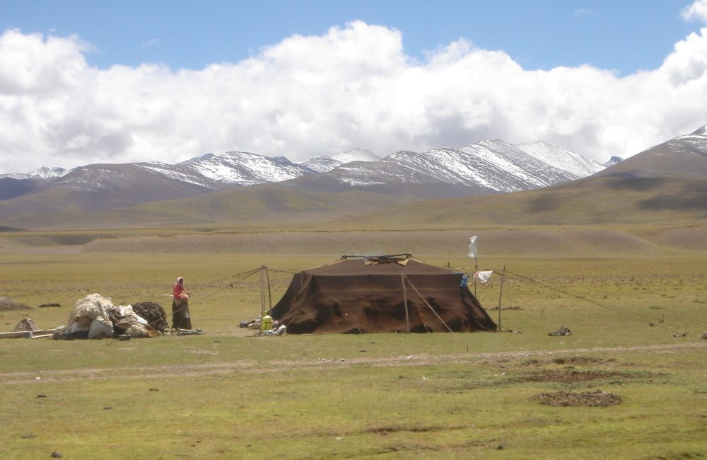
 Pastoral nomads camping near Namtso (2005)
 Namtso at summer time
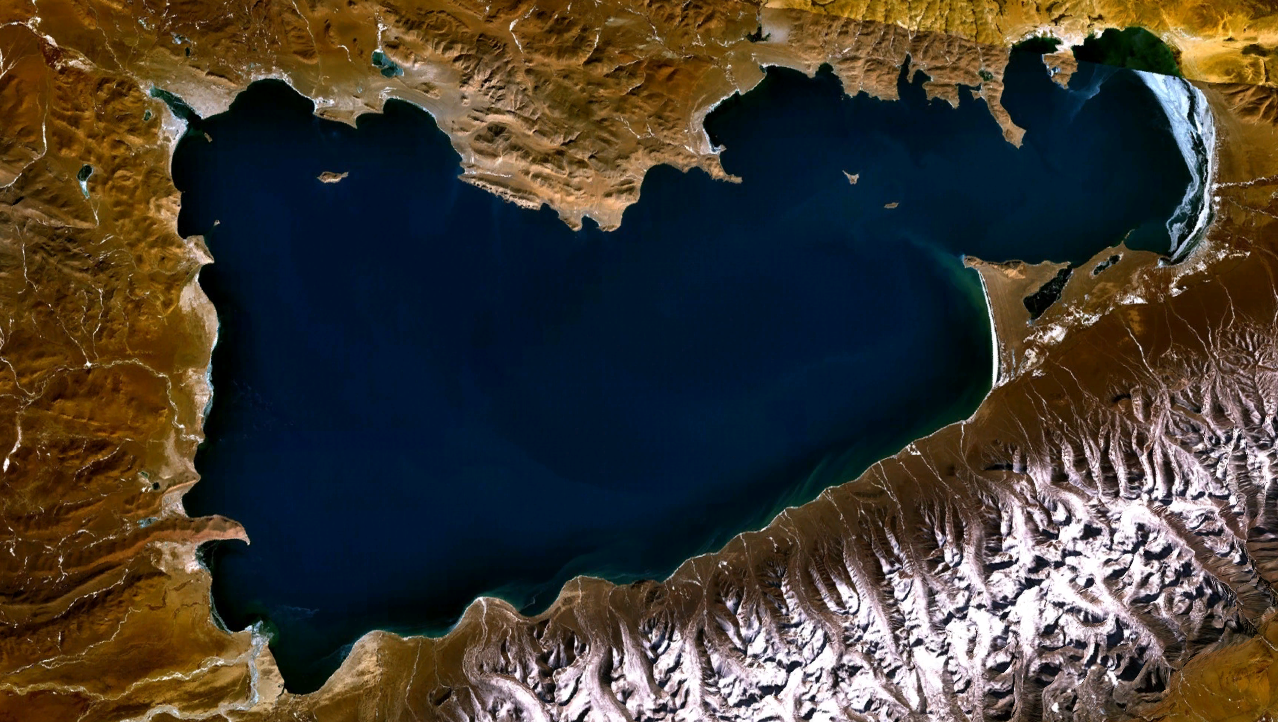
 Namtso from space, courtesy NASA
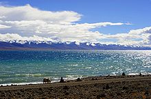 Namtso
See also
- Laken Pass (Lakenla)
- Kanas lake
References
- ^ Chinese, German scientists record new depth of Nam Co Lake
- ^ http://koalasplayground.com/2010/10/24/hu-ge-in-the-historical-drama-shangri-la/
- ^ http://video.sina.com.cn/p/ent/v/m/2011-04-29/153061326513.html
External links
Lhünzhub · Damxung · Nyêmo · Qüxü · Doilungdêqên · Dagzê · Maizhokunggar · Chengguan District
Towns and villages Monasteries
and palacesArchitecture of Lhasa · Lingkhor · Potala Palace · Norbulingka · Jokhang Temple · Tsomon Ling · Ganden Monastery · · Kundeling Monastery · Nechung · Nyethang Drolma Lhakhang Temple · Yangpachen Monastery · · Drepung Monastery · Ramoche Temple · Reting Monastery · Sanga Monastery · Yerpa
Sera Monastery: · Chupzang Nunnery · Drakri Hermitage · Garu Nunnery · Jokpo Hermitage · Keutsang Hermitage · Keutsang East Hermitage · Keutsang West Hermitage · Khardo Hermitage · Negodong Nunnery · Nenang Nunnery · Pabongkha Hermitage · Panglung Hermitage · Purbuchok Hermitage · Rakhadrak Hermitage · Sera Chöding Hermitage · Sera Gönpasar Hermitage · Sera Utsé Hermitage · Takten Hermitage · Trashi Chöling HermitageOther landmarks Banak Shöl Hotel · Barkhor · Chokpori · Drapchi Prison · Lhasa Brewery · Lhasa Hotel · Lhasa Zhol Pillar · Tibet Museum · Tibet University · Tromzikhang · Nyang bran · Hutoushan ReservoirTransport Lhasa Airport · Damxung Railway Station · Lhasa Railway Station · Lhasa West Railway Station · Wumatang railway station · Yangbajain Railway Station · G109 · G318 · North Linkor RoadGovernment Doje Cezhug · Jigme Namgyal
Lakes of China Famous Freshwater Lakes Xingkai Lake • Poyang Lake • Lake Dongting • Lake Tai • Hulun Lake • Lake Hongze • Nansi Lake • Bosten Lake • Lake Chao • Gaoyou Lake • Ngoring Lake • Gyaring Lake • Lake Sayram • Baiyangdian Lake • Hong Lake • Longgan Lake • Liangzi Lake • Dian Lake • Ulansuhai Nur • Luoma Lake • Erhai Lake • Junshan Lake • Fuxian Lake • Shijiu Lake • Wabu Lake • Nanyi Lake • Dongping Lake • Ge Lake • Yangcheng Lake • Chenghai Lake • Dianshan Lake • Yangzong Lake • Xingyun Lake • Qilu Lake • Yilong Lake • Ayding Lake • Buir Lake • Chagan Lake (China) • Daming Lake • Diexi Lake • Dongqian Lake • Heaven Lake • Hundred Flower Pond • Karakul (China) • Kunming Lake • Lugu Lake • Ruyi Lake • South Lake (Jiaxing) • Tangjiashan Lake • White Cloud Lake • Xuanwu Lake • Yueya Lake (Nanjing)
Famous Salt Lakes Qinghai Lake • Namtso • Serling Lake • Zhari Namco • Tangra Yumco • Ulungur Lake • Yamdrok Lake • Pangong Tso • Lake Rakshastal • Aibi Lake • Ayding LakeNational Park Jingpo Lake • Wudalianchi Lake • Lake Tai • West Lake • East Lake (Wuhan) • Tianchi Lake (Tianshan) • Songhua Lake • Jingyue Lake • Slim West Lake • Lake Dongting • Hongfeng Lake • Lake Dian • Lake Jin (Taining) • Crescent Lake (Dunhuang) • Qinghai Lake • Lake Chao • Fairy Lake • West Lake (Huizhou) • Lake Qiong • Bosten Lake • Feiyun Lake • Huguang Rock • Bailong Lake • Lake Sayram • Huating Lake • Zhelin LakeProtected Wetlands Dongting Lake • Poyang Lake • Dalai Nur • South Dongting Lake • West Dongting Lake • Xingkai Lake • Bita Lake • Lake Napa • Lashi Lake • Ngoring Lake • Gyaring Lake • Manasarovar LakeNature Reserve Hengshui Lake • Xingkai Lake • Wudalianchi Lake • Shengjin Lake • Lake Poyang • Dongting Lake • Erhai Lake • Serling Lake • West Lake (Dunhuang) • Gahai Lake • Qinghai Lake • Caohai Lake • Dalai Nur • Kanas Lake • Lake Hongze • Haba LakeReservoirs Three Gorges Dam • Longtan Dam • Longyangxia Dam • Danjiangkou Dam • Sapung Lake • Qiandao Lake • Xinfengjiang Reservoir • Liujiaxia Reservoir • Changshou Lake • Yantan Dam • Jiangkou Reservoir • See also: List of dams and reservoirs in ChinaCategories:- Lakes of China
- Lakes of Tibet
- Buddhist pilgrimages
- Lhasa Prefecture
- Saline lakes


Wikimedia Foundation. 2010.