- Lesja
Infobox_Kommune
name=Lesja
idnumber=0512
county=Oppland
landscape=Gudbrandsdalen
capital=Lesja
governor=Per Dag Hole (Sp)
governor_as_of=2003
arearank=22
area=2259
arealand=2168
areapercent=0.70
population_as_of=2004
populationrank=325
population=2,209
populationpercent=0.05
populationdensity=1
populationincrease=-11.7
language=Neutral
lat_deg=62| lat_min=12| lat_sec=38| lon_deg=8| lon_min=38| lon_sec=41
utm_zone=32V| utm_northing=6897714 |utm_easting=0481530| geo_cat=adm2nd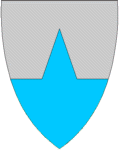
munwebpage=www.lesja.kommune.noLesja is a municipality in the county of Oppland,
Norway .The parish of "Lesje" was established as a municipality January 1, 1838 (see
formannskapsdistrikt ).Dovre was separated from Lesja as a municipality of its own in 1861.Lesja is bordered in the north by the municipalities of
Nesset ,Sunndal andOppdal , in the east byDovre , in the south byVågå and Lom, in the south-west bySkjåk , and to the west by Rauma.Name
The Norse form of the name was "Lesjar" (plural form). There are two different interpretations of the meaning of the name. It might derive from "læs" f 'pasture', or it is a shortened version of "Leirsjøar" meaning "muddy lakes", referring to two relatively large and shallow lakes which occupied the valleybottom until the late 19th Century, when both lakes were drained by men in order to gain farmland.
Coat-of-arms
The coat-of-arms is from 1987. The form is meant to represent the spire of Lesja church (which is visible from far away).
Geography
Lesja is highly mountainous, and lies on the east-west watershed, with
Lesjaskogsvatnet lake draining both west to the Rauma river and east to theGudbrandsdalslågen river. The largest part (82%) of the community area is over 900 m above sea level, with the highest mountain peaks reaching above 2200 m a.s.l. in the northeast. The most populated areas lie between 500 and 650 m along the Gudbrandsdalslågen river and highway E136. Abundant summer farms (seter orsæter ) are situated close to the treeline, both in the main valley and its tributaries. The summer farms were of major importance for farming until recently, but today only few are used in the traditional way, and mainly as grounds for grazing dairy cattle and sheep. More than 400 lakes are situated within the municipality, mainly above treeline. The Norwegian trout is common both in lakes and rivers, even in lakes above 1500 m a.s.l. The landscape is hummocky in general, and owes its appearance mainly to erosion by the Scandinavian Ice Sheet during the last glacial.Dovrefjell-Sunndalsfjella National Park
Dovrefjell-Sunndalsfjella National Park was founded in 2002 and encompasses part of the former Dovre National Park area, as originally founded in 1974. It is 1,693 km² encompassing areas in Lesja and Dovre in Oppland as well as areas inSør-Trøndelag , andMøre og Romsdal . It includes theDovrefjell mountain range.Commerce and industry
The community is primarily agricultural. Recent censuses show over 40% of the occupations in the community in farming.
Rail service is provided by the
Raumabanen , connecting with theDovrebanen atDombås in Dovre and extending to the terminus inÅndalsnes on the Fjord inMøre and Romsdal County.Lesja is located in a mountain region, comprising the south-westerly portion of the
Dovrefjell range. It is the site of theDovrefjell-Sunndalsfjella National Park , lies just north ofJotunheimen National Park and lies just west ofRondane National Park , so tourism and outdoor sports such as skiing are also important. The Bjorli ski area lies in Lesja.History
~1015 - Lesja is mentioned in the
Heimskringla (The Chronicle of the Kings of Norway) bySnorri Sturluson . The account of King Olaf's (A.D. 1015-1021)conversion of Dale-Gudbrand to Christianity is popularly recognized.1029 – King Olaf's success was short-lived, for in
1029 the Norwegian nobles, seething with discontent, rallied round the invading Knut the Great, and Olaf had to flee. To avoid engaging a fleet of 25 ships, 400 of King Olav's men and 100 loyal peasant farmers fromRomsdal built a road up from theRomsdalfjord to Lesja municipality. Using this road, his men fled across Gudbrandsdal. There he was not warmly received since he had killed King Thorer of Gudbrandsdal, so he went on toHedmark . From there he proceeded to Sweden and on to Russia. On his return a year later he fell at theBattle of Stiklestad .1659 to 1812 –
Lesjaverk (Lesja Iron Works) was an important Norwegian iron works.1710 to 1773 - Jakob Bersveinson Klukstad, who was born in Lom but spent most of his career on Klukstad farm in Lesja, was the foremost Norwegian sculptor and painter. His work can still be seen in churches at Lesja,
Skjåk andHeidal .1867 - The Lesja area in the
Gudbrandsdal was source of numerous emigrants to America: "...during the great famine of 1867; a year memorable in the annals of Northern Europe, when, in consequence of an early and heavy frost in summer, the crops were destroyed, and desolation and death spread over vast districts. The lichen and the bark of the birch tree, mixed with a little flour, became the food of the people after the cattle had been eaten up and nothing else was left. The year following a strong tide of emigration set out for America." (Reference: Du Chaillu)1940 - After the German invasion of April 1940, while King Haakan and the Norwegian government were moving from
Elverum to the west coast, the King and Crown Prince Olaf arrived inOtta on the night of April 13th. The prime minister and his colleagues, who were then in Lesja, were summoned and a communiqué, ending "God save Norway," and urging resistance to the unprovoked attack was issued. They now intended to relocate to the west coast, but the Germans had dropped paratroopers higher in the Gudbrandsdalen, at Dombås, cutting off the rail route. It was not until the evening of the 21st that the King was able to travel by road from Otta to Lesja on the east-west watershed and then down the narrowRomsdal to Åndalsnes. (Reference: Greve)During the war a British fighter squadron (flying 'Gloster Gladiators') flew from the icebound surface of lake Lesjaskogsvatnet.
Famous residents
*
Jakob Klukstad , artist
*Lars Berger , biathlete
*Tora Berger , biathleteExternal links
* [http://english.dirnat.no/wbch3.exe?p=3038 Norway's National Mountains] Norwegian Government's pages on the Dovrefjell-Sunndalsfjella National Park
* [http://english.dirnat.no/archive/images/01/65/NPmap063.jpgMap of the Dovrefjell-Sunndalsfjella National Park]
* [http://www.bjorliskisenter.no/ Bjorli ski center in Lesja (Norwegian text only)]
* [http://www.kulturnett.no/geografisknavigering/geografisknavigering_visning.jsp?fylke=T946673&kommune=T936310&organisasjon=T959974&organisasjon=T5160011&organisasjon=T948714&organisasjon=T909568&organisasjon=T942316&organisasjon=T961636&x=25&y=9 Map of Lesja] fromKulturnett.no (in Norwegian).References
*
List of farms in Lesja
* "East Norway & its Frontier" by Frank Noel Stagg, 1956.
* "Årsskrift for Lesja historielag, 2000" (in Norwegian)
* "The Land Of The Midnight Sun", by Paul B. Du Chaillu; Publisher: George Newnes, Limited; London; 1899. Page 123
* "Haakon VII of Norway" by Tim Greve and translated by Thomas Kingston Derry, Hippocrene Books, Inc., 1983 ISBN 0-88254-812-3
* "Lesja og Dovre" byIvar Kleiven
*"Setrane i Lesja - i teikning og teks", (" Manors in Lesja - in drawings and text ") byArnfinn Kjelland ,1988 . 256 p. (drawings by Per Einbu).
*"Bygdebok for Lesja bd 1. Gards- og slektshistorie for Lesjaskogen", by Arnfin Kjelland, ("Rural district for Lesja 1. Farm and genealogical history of Lesja woods")1987 . 634 p.
*"Bygdebok for Lesja bd 2. Gards- og slektshistorie for nørdre del av Lesja hovudsokn", by Arnfinn Kjelland,1992 . 736 p.
*"Bygdebok for Lesja bd 3. Gards- og slektshistorie for søre del av Lesja hovudsokn", by Arnfin Kjelland,1996 . 800 p.
Wikimedia Foundation. 2010.