- Osterøy
-
Osterøy kommune — Municipality — 
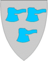
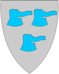
Coat of arms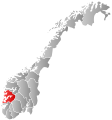
Hordaland within
NorwayOsterøy within Hordaland
Coordinates: 60°31′5″N 5°32′29″E / 60.51806°N 5.54139°ECoordinates: 60°31′5″N 5°32′29″E / 60.51806°N 5.54139°E Country Norway County Hordaland District Nordhordland Administrative centre Lonevåg Government – Mayor (2003) Kari Foseid Aakre (Ap) Area – Total 275 km2 (106.2 sq mi) – Land 270 km2 (104.2 sq mi) Area rank 288 in Norway Population (2008) – Total 7,305 – Rank 140 in Norway – Density 27/km2 (69.9/sq mi) – Change (10 years) 2.8 % Demonym Ostring[1] Time zone CET (UTC+1) – Summer (DST) CEST (UTC+2) ISO 3166 code NO-1253 Official language form Nynorsk Website www.osteroy.kommune.no Data from Statistics Norway Historical populations Year Pop. ±% 1951 2,688 — 1960 2,513 −6.5% 1970 5,660 +125.2% 1980 6,579 +16.2% 1990 7,016 +6.6% 2000 7,006 −0.1% 2010 7,385 +5.4% 2020 7,905 +7.0% 2030 8,495 +7.5% Source: Statistics Norway. Osterøy is an island municipality in the county of Hordaland, Norway. It is located in the traditional district of Nordhordland. The administrative centre is located in Lonevåg in the central part of the island, while the settlement with the largest population is Valestrandfossen with 1,012 inhabitants as of 1 January 2008.[2]
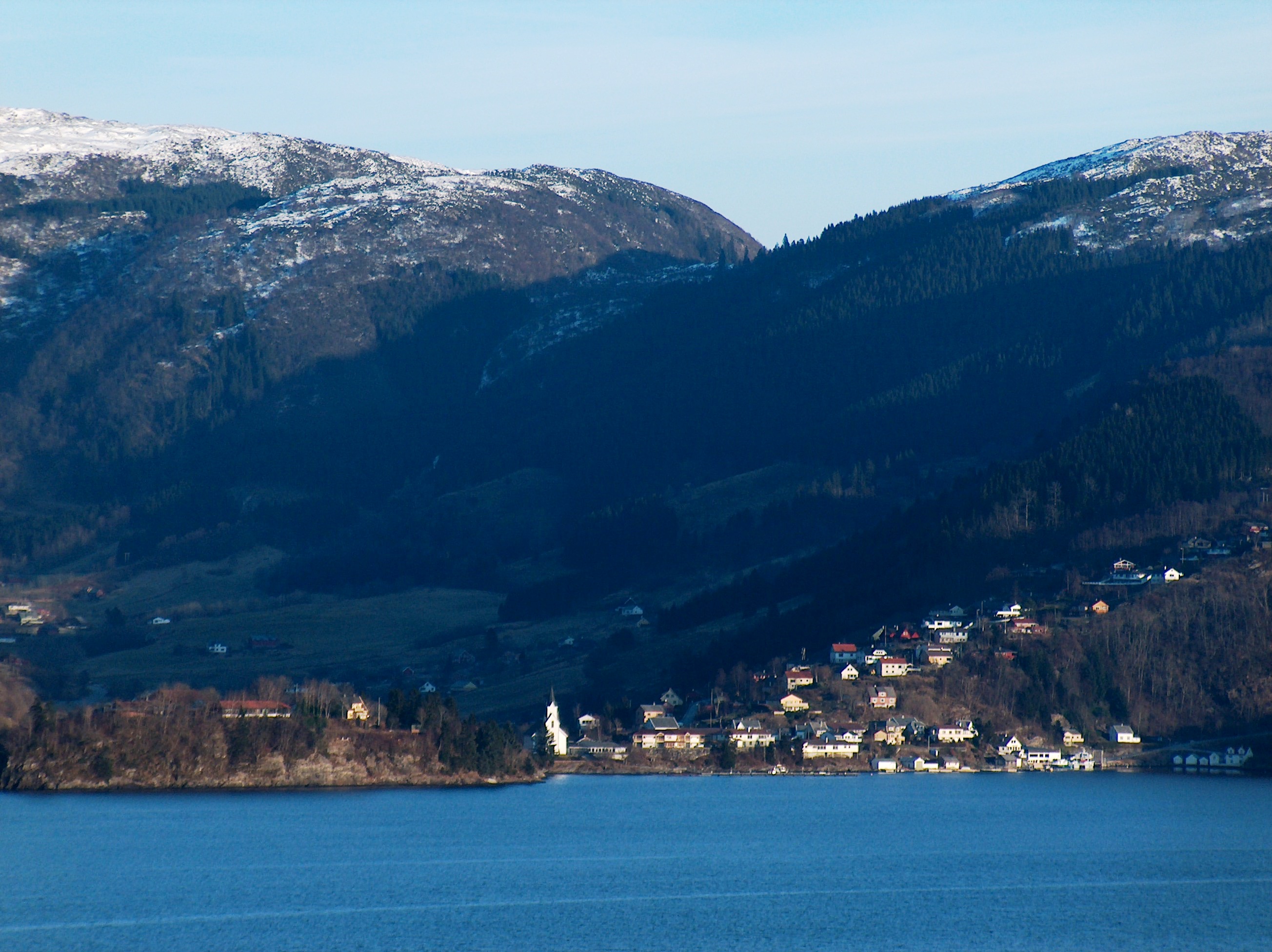
Osterøy municipality covers the majority of the island of the same name, although the mostly uninhabited north-eastern part is part of Vaksdal municipality. Osterøy is located just northeast of Bergen, and is surrounded by the fjords Osterfjorden and Sørfjorden. The 19th century musician and composer Ole Bull had a home on the island at Valestrandfossen. The Havrå farm is located on the island.
Contents
History
Osterøy municipality was created on 1 January 1964. Part of Haus (population: 2,327), the Bruvikbygda area of Bruvik (population: 409), part of the municipality of Hosanger (population: 1,616), and part of the municipality of Hamre (population: 1,166) were merged to form the new municipality of Osterøy.[3]
Name
The Old Norse form of the name was "Óstr". The last element "øy" which means "island" was added later. The meaning of the name is unknown. It is possible that it comes from the word "óstr" which means "the arch of the neck"--words for parts of the body are common in Norwegian place names.[citation needed]
Geography
Further information: Osterøy (island)Høgafjellet is at 868 metres above sea level the highest mountain in Osterøy.
Settlements
Osterøy contains four urban settlements, as defined by Statistics Norway and as of 1 January 2008:[2]
- Valestrandfossen (1,012 inhabitants)
- Lonevåg (557 inhabitants)
- Hausvik (553 inhabitants)
- Fotlandsvåg (230 inhabitants)
Transport
The Osterøy Bridge, finished in 1997, provides Osterøy with a permanent road connection to the mainland in Bergen municipality. The bridge has a main span of 595 metres, the third longest suspension bridge main span in Norway, and a total span of 917 metres.
Culture
Coat-of-arms
The coat-of-arms was granted on 20 December 1985. It shows three broad axes pointing downwards on a field of white, with two axes at the top and one beneath. Broad axes are used in the construction of timber houses, which has long traditions in the municipality. The designer was Egil Korsnes who based his design on the idea of Magnus Hardeland.[4][5]
Administration and politics
Since 2007, the mayor of Osterøy has been Kari Foseid Aakre from the Norwegian Labour Party.[6]
People from Osterøy
- Tore Eikeland (1990-2011), politician
- Erlend Hanstveit (born 1981), footballer
- Mons Ivar Mjelde (born 1967), footballer and coach
- Sylvelin Vatle (born 1957), novelist and children's writer
References
- ^ "Personnemningar til stadnamn i Noreg" (in Norwegian). Språkrådet. http://www.sprakrad.no/nb-no/Sprakhjelp/Rettskrivning_Ordboeker/Innbyggjarnamn/.
- ^ a b "Urban settlements. Population and area, by municipality.". Statistisk sentralbyrå. 1 January 2008. http://www.ssb.no/english/subjects/02/01/10/beftett_en/tab-2008-06-20-01-en.html. Retrieved 10 September 2008.[dead link]
- ^ Jukvam, Dag (1999). "Historisk oversikt over endringer i kommune- og fylkesinndelingen" (PDF). Statistisk sentralbyrå. http://www.ssb.no/emner/00/90/rapp_9913/rapp_9913.pdf. (Norwegian)
- ^ "Osterøy". Norske Kommunevåpen. http://www.ngw.nl/int/nor/o/osteroy.htm. Retrieved 7 September 2008.
- ^ "Kommunevåpen". Flags of the World. 28 June 2002. http://www.fotw.us/flags/no-12-53.html. Retrieved 22 September 2008.
- ^ "Osterøy kommune" (in Norwegian). Osterøy kommune. http://www.osteroy.kommune.no/artikkel.aspx?AId=888&back=1&MId1=31&MId2=32. Retrieved 2008-09-10.
External links
 Media related to Osterøy at Wikimedia Commons
Municipalities of Hordaland Nordhordland 
Voss Hardanger Midthordland Sunnhordland Categories:- Municipalities of Hordaland
- Osterøy


Wikimedia Foundation. 2010.