- Purba Medinipur district
-
Purba Medinipur district
পূ্র্ব মেদিনীপুর জেলা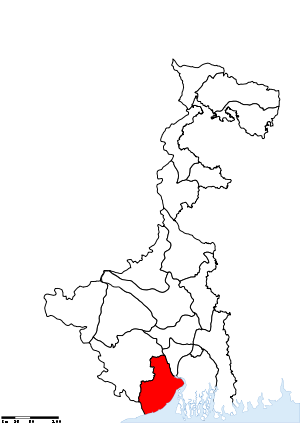
Location of Purba Medinipur district in West BengalState West Bengal,  India
IndiaAdministrative division Burdwan Headquarters Tamluk Area 4,736 km2 (1,829 sq mi) Population 50,94,238 (2011) Population density 1,076 /km2 (2,790 /sq mi) Literacy 87.66 per cent Sex ratio 936 Lok Sabha Constituencies Kanthi (Contai), Tamluk, Ghatal (partly), Medinipur (partly) Assembly Seats Tamluk, Panskura Purba, Panskura Paschim, Moyna, Nandakumar, Mahisadal, Haldia, Nandigram, Chandipur, Patashpur, Kanthi Uttar, Bhagabanpur, Khejuri, Kanthi Dakshin, Ramnagar, Egra Major highways NH 6, NH 41 Official website For other uses, see Midnapore (disambiguation).
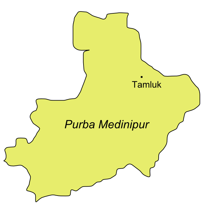
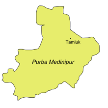 Map of Purba Medinipur showing Tamluk
Purba Medinipur district (Bengali: পূর্ব মেদিনীপুর জেলা), or East Midnapore district is an administrative unit in the Indian state of West Bengal. It is the southernmost district of Burdwan division – one of the three administrative divisions of West Bengal. The headquarter is located at Tamluk. It was formed on January 1, 2002 after the Partition of Midnapore into Purba Medinipur and Paschim Medinipur which lies at the northern and western border of it. The state of Orissa is at the south-west border whereas the Bay of Bengal lies in the south; the Hooghly river and South 24 Parganas district to the east and Howrah district to the north-east.
Purba Medinipur is formed of the sub-divisions of Tamluk, Contai and Haldia of erstwhile Midnapore district.[1] Another sub-division, Egra has been created out of the erstwhile Contai sub-division during the partition of Midnapore. In 2011, the state government has proposed to rename the district as Tamralipta district after the ancient port city of Tamralipta which used to lie near the modern district headquarter.
Purba Medinipur saw many political movements during the British Raj. A parallel government named the Tamralipta Jatiya Sarkar was formed during the Quit India Movement in Tamluk.[2] In 2007, Purba Medinipur witnessed the Nandigram violence, an incident of police firing that killed 14 farmers.[3]
Contents
Geography
Major cities and towns
Major cities and towns include: Panskura, Tamluk, Contai, Egra, Haldia, Mecheda, Mahisadal, Nandigram, Digha, Mandarmani, Khejuri, Ramnagar, Patashpur, Bhagabanpur, Manglamarro, Chandipur, Nandaigajan, Kolaghat and Paniparul.
Economy
In 2006 the Ministry of Panchayati Raj named Purba Medinipur one of the country's 250 most backward districts (out of a total of 640).[4] It is one of the eleven districts in West Bengal currently receiving funds from the Backward Regions Grant Fund Programme (BRGF).[4]
Divisions
Administrative subdivisions
The district comprises four subdivisions: Tamluk, Haldia, Egra and Contai. Tamluk subdivision consists of Tamluk municipality, Panskura municipality and seven community development blocks: Nandakumar, Mayna, Tamluk, Shahid Matangini, Panskura–I, Panskura–II and Chandipur (Nadigram–III). Haldia subdivision consists of Haldia municipality and five community development blocks: Mahisadal, Nandigram–I, Nandigram–II, Sutahata and Haldia. Egra subdivision consists of Egra municipality and six community development blocks: Bhagawanpur–I, Bhagawanpur–II, Egra–I, Egra–II, Pataspur–I and Pataspur–II. Contai subdivision consists of Contai municipality and seven community development blocks: Kanthi–I, Kanthi–II, Kanthi–III, Khejuri–I, Khejuri–II, Ramnagar–I and Ramnagar–II.[5]
Tamluk is the district headquarters. There are 21 police stations, 25 development blocks, 5 municipalities and 223 gram panchayats in this district.[5][6]
Other than municipality area, each subdivision contains community development blocks which in turn are divided into rural areas and census towns. In total there are 10 urban units: 5 municipalities and 5 census towns.[6] Panskura municipality was established in 2001.[7]
Tamluk subdivision
- Two municipalities: Tamluk and Panskura.
- Nandakumar community development block consists of rural areas only with 12 gram panchayats.
- Moyna community development block consists of rural areas with 11 gram panchayats and one census town: Goasafat.
- Tamluk community development block consists of rural areas with 12 gram panchayats and one census town: Dakshin Baguan.
- Shahid Matangini community development block consists of rural areas with 10 gram panchayats and one census town: Kakdihi.
- Panskura–I community development block consists of rural areas with 14 gram panchayats and one census town: Bahirgram.
- Panskura–II community development block consists of rural areas with 13 gram panchayats and one census town: Kolaghat.
- Chandipur (Nadigram–III) community development block consists of rural areas only with 10 gram panchayats.
- barkshimpur one of the most historical place
Haldia subdivision
- One municipality: Haldia.
- Mahisadal community development block consists of rural areas only with 11 gram panchayats.
- Nandigram–I community development block consists of rural areas only with 10 gram panchayats.
- Nandigram–II community development block consists of rural areas only with 7 gram panchayats.
- Sutahata community development block consists of rural areas only with 6 gram panchayats.
- Haldia community development block consists of rural areas only with 4 gram panchayats.
Egra subdivision
- One municipality: Egra.
- Bhagabanpur–I community development block consists of rural areas only with 10 gram panchayats.
- Bhagabanpur–II community development block consists of rural areas only with 9 gram panchayats.
- Egra–I community development block consists of rural areas only with 8 gram panchayats.
- Egra–II community development block consists of rural areas only with 8 gram panchayats.
- Pataspur–I community development block consists of rural areas only with 9 gram panchayats.
- Pataspur–II community development block consists of rural areas only with 7 gram panchayats.
Contai subdivision
- One municipality: Contai.
- Kanthi–I community development block consists of rural areas only with 8 gram panchayats.
- Kanthi–II community development block consists of rural areas only with 8 gram panchayats.
- Kanthi–III community development block consists of rural areas only with 8 gram panchayats.
- Khejuri–I community development block consists of rural areas only with 6 gram panchayats.
- Khejuri–II community development block consists of rural areas only with 5 gram panchayats.
- Ramnagar–I community development block consists of rural areas only with 9 gram panchayats.
- Ramnagar–II community development block consists of rural areas only with 8 gram panchayats.
Demographics
According to the 2011 census Purba Medinipur district has a population of 5,094,238 ,[8] roughly equal to the United Arab Emirates[9] or the US state of Colorado.[10] This gives it a ranking of 20th in India (out of a total of 640).[8] The district has a population density of 1,076 inhabitants per square kilometre (2,790 /sq mi) .[8] Its population growth rate over the decade 2001-2011 was 15.32 %.[8] Purba Medinipur has a sex ratio of 936 females for every 1000 males,[8] and a literacy rate of 87.66 %.[8]
Culture
Places of interest
- Mandarmani - 13 km long sea beach near Digha
- Digha - a beautiful sea beach
References
- ^ Jana, Naresh (2001-12-31). "Tamluk readies for giant's partition". The Telegraph (Kolkata). http://www.telegraphindia.com/1011231/national.htm#head3. Retrieved 2008-09-01.
- ^ "Sushil Dhara:Dreams of ’42 Sevice in ‘90’s". janasamachar.net.. http://www.jansamachar.net/display.php3?id=&num=1287&lang=English. Retrieved 2009-08-22.
- ^ "Red-hand Buddha: 14 killed in Nandigram re-entry bid". The Telegraph. 15 March 2007. http://www.telegraphindia.com/1070315/asp/frontpage/story_7519166.asp. Retrieved 2007-03-15.
- ^ a b Ministry of Panchayati Raj (September 8, 2009). "A Note on the Backward Regions Grant Fund Programme". National Institute of Rural Development. http://www.nird.org.in/brgf/doc/brgf_BackgroundNote.pdf. Retrieved September 27, 2011.
- ^ a b "Directory of District, Sub division, Panchayat Samiti/ Block and Gram Panchayats in West Bengal, March 2008". West Bengal. National Informatics Centre, India. 2008-03-19. http://wbdemo5.nic.in/writereaddata/Directoryof_District_Block_GPs(RevisedMarch-2008).doc. Retrieved 2008-12-06.
- ^ a b "Administration Setup". Official website of Purba Medinipur district. http://purbamedinipur.gov.in/ADMIN.htm. Retrieved 2008-12-06.[dead link]
- ^ "Municipalities: Panskura Municipality". Department of Urban Development, West Bengal. http://www.jnnurmwestbengal.gov.in/DIS/MUNI_ULB_Panskura.htm. Retrieved 2008-12-06.
- ^ a b c d e f "District Census 2011". Census2011.co.in. 2011. http://www.census2011.co.in/district.php. Retrieved 2011-09-30.
- ^ US Directorate of Intelligence. "Country Comparison:Population". https://www.cia.gov/library/publications/the-world-factbook/rankorder/2119rank.html. Retrieved 2011-10-01. "United Arab Emirates 5,148,664"
- ^ "2010 Resident Population Data". U. S. Census Bureau. http://2010.census.gov/2010census/data/apportionment-pop-text.php. Retrieved 2011-09-30. "Colorado 5,029,196"
External links
- Official website
- Legacy of Midnapore(Medinipur,Midnapur,Purba Medinipur, Paschim Medinipur,East Midnapore,West Midnapore)
- News of district bifurcation
- Map of old Medinipur district (district has now been split)

Howrah district West Midnapore district 
South 24 Parganas district  Purba Medinipur district

Balasore district, Orissa Bay of Bengal Divisions & Districts of West Bengal Burdwan division Jalpaiguri division Presidency division Cities and towns in Purba Medinipur District Tamluk subdivision Haldia subdivision Egra subdivision Contai subdivision Related topics Purba Medinipur topics · People from Purba Medinipur district · Villages in Purba Medinipur districtCities and towns
in other districtsBankura · Bardhaman · Birbhum · Cooch Behar · Dakshin Dinajpur · Darjeeling · Hooghly · Howrah · Jalpaiguri · Malda · Murshidabad · Nadia · North 24 Parganas · Paschim Medinipur · Purulia · South 24 Parganas · Uttar DinajpurPurba Medinipur district topics General Subdivisions Territories Locations
other than cities and townsMunicipalities Community development blocks Tamluk subdivision Nandakumar • Moyna • Tamluk • Sahid Matangini • Panskura I • Panskura II • Chandipur Haldia subdivision Mahisadal • Nandigram I • Nandigram II • Sutahata • Haldia Egra subdivision Bhagabanpur I • Bhagabanpur II • Egra I • Egra II • Patashpur I • Patashpur II Contai subdivision Contai I • Contai II • Contai III • Khejuri I • Khejuri II • Ramnagar I • Ramnagar IIRivers Transport Lok Sabha constituencies Vidhan Sabha constituencies Tamluk • Panskura Purba • Panskura Paschim • Moyna • Nandakumar • Mahisadal • Haldia • Nandigram • Chandipur • Patashpur • Kanthi Uttar • Bhagabanpur • Khejuri • Kanthi Dakshin • Ramnagar • EgraFormer Vidhan Sabha constituencies See also Cities and towns in Purba Medinipur district • People from Purba Medinipur district • Villages in Purba Medinipur district • Damodar ValleyOther districts in West Bengal Bankura • Bardhaman • Birbhum • Cooch Behar • Dakshin Dinajpur • Darjeeling • Hooghly · Howrah • Jalpaiguri • Kolkata • Malda • Murshidabad · Nadia • North 24 Parganas • Paschim Medinipur • Purulia • South 24 Parganas • Uttar DinajpurSurrounding areas outside West Bengal Categories:


Wikimedia Foundation. 2010.