- Ørskog
-
Ørskog kommune — Municipality — 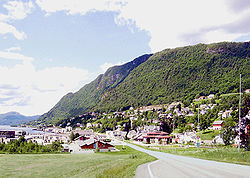

Coat of arms
Møre og Romsdal within
NorwayØrskog within Møre og Romsdal
Coordinates: 62°28′44″N 6°53′7″E / 62.47889°N 6.88528°ECoordinates: 62°28′44″N 6°53′7″E / 62.47889°N 6.88528°E Country Norway County Møre og Romsdal District Sunnmøre Administrative centre Sjøholt Government – Mayor (2003) Sigmund Stene (H) Area – Total 132.30 km2 (51.1 sq mi) – Land 128.85 km2 (49.7 sq mi) – Water 3.45 km2 (1.3 sq mi) Area rank 368 in Norway Population (2010) – Total 2,138 – Rank 335 in Norway – Density 16.6/km2 (43/sq mi) – Change (10 years) 3.0 % Demonym Ørskogbygdar[1] Time zone CET (UTC+1) – Summer (DST) CEST (UTC+2) ISO 3166 code NO-1523 Official language form Nynorsk Website www.orskog.kommune.no Data from Statistics Norway Ørskog is a municipality in Møre og Romsdal county, Norway. It is part of the Sunnmøre region. The administrative centre is the village of Sjøholt. European Route E39 and European Route E136 runs through the municipality, connecting the towns of Ålesund and Molde.
Contents
General information
Ørskog was established as a municipality on 1 January 1838 (see formannskapsdistrikt). The municipality of Sykkylven was separated from Ørskog on 1 August 1883. This left Ørskog with 1,735 inhabitants. The municipalities of Skodje and Stordal were briefly merged into Ørskog on 1 January 1965, and then they were separated from Ørskog again on 1 January 1977.[2]
Name
The municipality (originally the parish) is named after the old Ørskog farm (Old Norse: Øyraskógr), since the first church was built there. The first element is the plural genitive case of øyrr which means "shoal" and the last element is skógr which means "wood" or "forest".[3]
Coat-of-arms
The coat-of-arms is from modern times. They were granted on 11 November 1983. The arms show a wooden pole as a symbol for forestry and fur farming. In the 17th century, the municipality exported many tall trees to the Dutch Republic, where they were used for shipbuilding. The ermine is a canting for the many animals in the forests.[4]
Churches
The Church of Norway has one parish with one church, within the municipality of Ørskog. It is part of the Diocese of Møre and the Rural Deanery (Prosti) of Austre Sunnmøre.
Churches in Ørskog Parish
(Sokn)Church Name Year Built Location
of the ChurchØrskog Ørskog kyrkje 1873 Sjøholt Geography
The municipality lies on the north shore of the Storfjord, and it is bordered by Skodje to the west, Vestnes to the north and east, and Stordal to the south.
References
- ^ "Personnemningar til stadnamn i Noreg" (in Norwegian). Språkrådet. http://www.sprakrad.no/nb-no/Sprakhjelp/Rettskrivning_Ordboeker/Innbyggjarnamn/.
- ^ Jukvam, Dag (1999). "Historisk oversikt over endringer i kommune- og fylkesinndelingen" (in Norwegian). Statistisk sentralbyrå. http://www.ssb.no/emner/00/90/rapp_9913/rapp_9913.pdf.
- ^ Rygh, Oluf (1908) (in Norwegian). Norske gaardnavne: Romsdals amt (13 ed.). Kristiania, Norge: W. C. Fabritius & sønners bogtrikkeri. pp. 152. http://books.google.com/books?id=yGtBAAAAIAAJ.
- ^ Norske Kommunevåpen (1990). "Nye kommunevåbener i Norden". http://www.ngw.nl/int/nor/o/orskog.htm. Retrieved 19 October 2008.
External links
 Media related to Ørskog at Wikimedia Commons
- Møre og Romsdal travel guide from Wikitravel
- Municipal fact sheet from Statistics Norway
Municipalities of Møre og Romsdal Categories:- Municipalities of Møre og Romsdal
- Ørskog
- Populated places established in 1838
- 1838 establishments in Norway


Wikimedia Foundation. 2010.