- Tysfjord
-
Tysfjord kommune — Municipality — 

Coat of arms
Nordland within
NorwayTysfjord within Nordland
Coordinates: 68°3′51″N 16°28′50″E / 68.06417°N 16.48056°ECoordinates: 68°3′51″N 16°28′50″E / 68.06417°N 16.48056°E Country Norway County Nordland District Ofoten Administrative centre Kjøpsvik Government – Mayor (2003) Kurt Allan Nilsen (Tverrpolitisk liste) Area – Total 1,464 km2 (565.3 sq mi) – Land 1,360 km2 (525.1 sq mi) Area rank 56 in Norway Population (2004) – Total 2,209 – Rank 326 in Norway – Density 2/km2 (5.2/sq mi) – Change (10 years) -11.8 % Demonym Tysfjerding[1] Time zone CET (UTC+1) – Summer (DST) CEST (UTC+2) ISO 3166 code NO-1850 Official language form Neutral and Lule Sami Website tysfjord.kommune.no Data from Statistics Norway Tysfjord (Norwegian) or Divtasvuodna (Lule Sami) is a municipality in Nordland county, Norway. It is part of the Ofoten traditional region. The administrative centre of the municipality is the village of Kjøpsvik. Tysfjord was separated from the municipality of Lødingen in 1869.
Tysfjord is the only municipality in Norway where speakers of Lule Sami should theoretically be able to speak that language with officials (since it is one of the official languages of the municipality), although this has not come to fruition. The Árran Lule Sami Center is located in the Tysfjord village of Drag.
Contents
General information
 Stetind mountain and the fjord
Name
The municipality is named after Tysfjorden. Tysfjord is a Norwegianized form of the Sami name Divtasvuodna (first recorded around 1520 as "Tyttisfiorden"). The meaning of the first element divtas is unknown. (A popular belief, and common interpretation, is that the first element should be the genitive case of the name of the Norse god Týr - but this does not fit either with the Sami form or the oldest spellings of the name.) The last element is vuodna which means "fjord".
Coat-of-arms
The coat-of-arms is from modern times. They were granted on 31 July 1987. The arms show a black lobster on a silver background. The lobsters in Tysfjord are the most northerly in the world.[2]
History
There are prehistoric rock carvings at Leiknes showing scenes of hunting, and the world's oldest known depiction of an Orca whale.
Economy
Due to the limestone in Tysfjord, a cement factory was established with production starting in 1920.[3] The modern Norcem factory still is a vital employer in Kjøpsvik, with about 130 employees; since 1999 part of the German world wide company Heidelberger Cement. Public services, some tourism, and agriculture are the other main sources of income in Tysfjord.
Geography
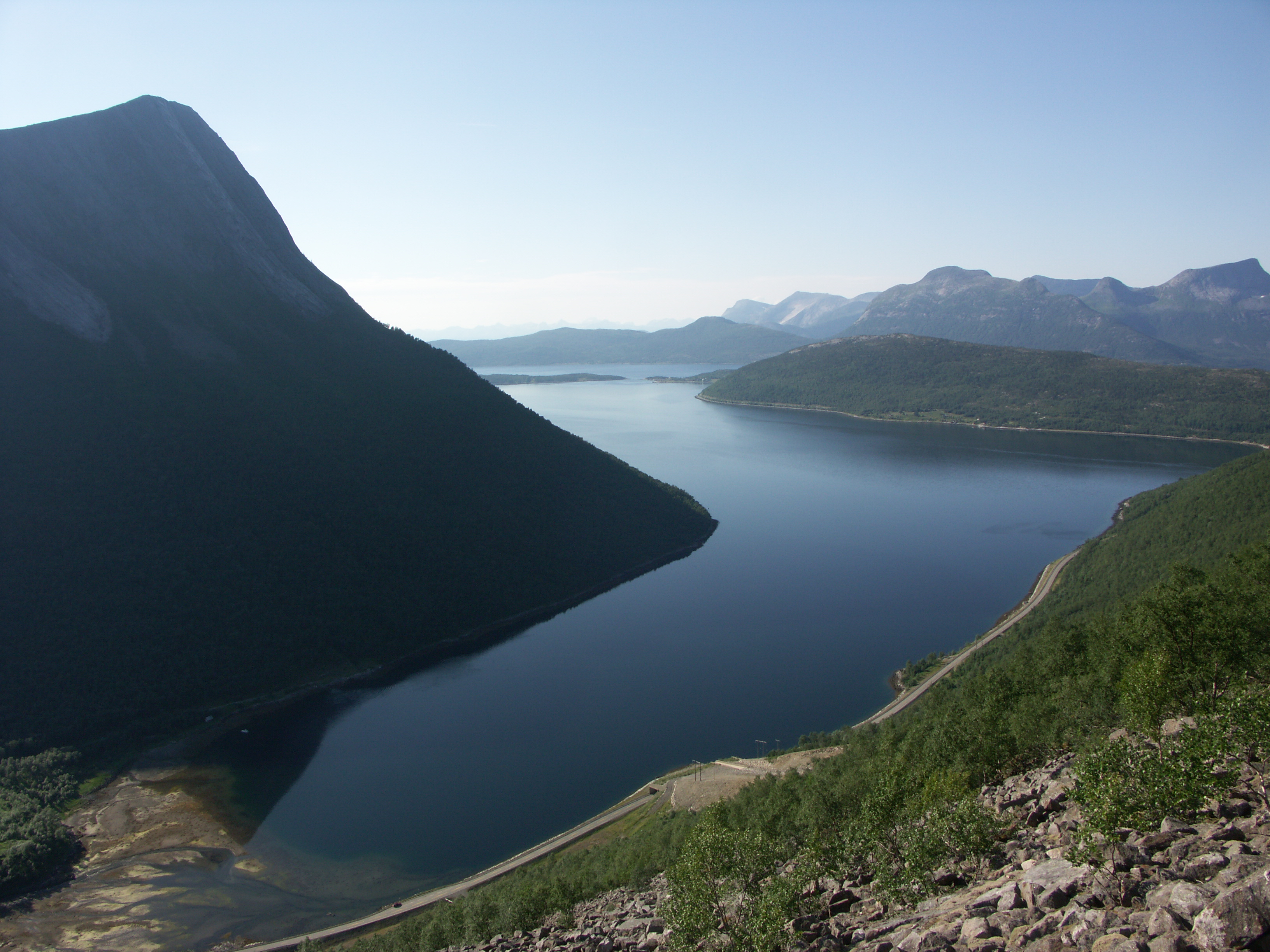
 Tysfjord municipality with fjords, mountains and a rarely visited glacier in the eastern part
The municipality is located along the Tysfjorden. The Tysfjorden is the second deepest fjord in Norway, with a maximum depth of 897 metres (2,943 ft).
The municipality borders Ballangen in the north, Hamarøy in the south, Sweden in the east, and Vestfjord in the northwest. The municipality is dominated by grey granite mountains; pine, birch, and aspen woodland and forests; and the many fjord branches. Tysfjord's most dominant mountain, Stetind, is famous in Norway. This 1,392 metres (4,567 ft) high natural granite obelisk, rising straight out of the fjord, is an awe-inspiring sight(Picture 1, Picture 2). In Norwegian, it is called gudenes ambolt which means the "anvil of the gods", partly because the summit forms a plateau. This was selected to be the national mountain of Norway in the autumn of 2002. The famous British climber William C. Slingsby described it as the ugliest mountain I ever saw; he did not reach the summit.
The mountains near the border with Sweden have peaks up to 1,500 metres (4,921 ft) above sea level, and with a large glacier, Gihtsejiegŋa. There are several nature reserves in Tysfjord. Mannfjordbotn reserve has undisturbed forests at the head of a narrow fjord branch surrounded by granite mountain walls.[4] From Hellemobotn, at the head of Hellemofjorden, the distance to the border with Sweden is only 6.3 kilometres (4 mi); this is also a scenic hiking terrain (Picture) with a canyon opening up in Hellemobotn (Picture). There are also caves, such as the very deep Raggejavreraige. Lakes in the region include Baugevatnet. Silver birch occurs in Tysfjord, as one of few areas in North Norway (Silver birch need more summer warmth than the more common Downy birch).
Nature
 Orca taking a look above the water
For many years following 1990, a large part of the stock of Norwegian Herring has stayed in the fjord in winter, one of the largest gatherings of biomass in the world. Large number of whales, orcas in particular, have followed to feed on the herring. This have attracted winter tourist from far away, but not in huge numbers. Since 2008, less herring and fewer orca have arrived in Tysfjord. Harbor porpoises, lobsters, sea eagles, ravens, otters and moose are all common in the Tysfjord area. A nearby lake is Båvrojávrre.
 Rugged fjord scenery in Tysfjord
The coastal municipality of Tysfjord is better known for its whale watching than its birdwatching but the region has still a lot to offer. Thanks to a range of habitats the area has a varied birdlife. Though the area has no large seabird colonies, there is a small nature reserve at Ramnholmen with breeding populations of Arctic Tern and Common Tern.
Climate
The climate is surprisingly temperate considering the location north of the Arctic circle. Mean annual temperature in Kjøpsvik is 4.2 °C (40 °F) and mean annual precipitation is 1,080 millimetres (42.5 in). Summer is usually pleasant, although there might be persistent rain. Average monthly 24-hr temperature in June, July, and August is 10.9 °C (52 °F), 13.3 °C (56 °F), and 12.5 °C (54 °F), with average daily high about 16 °C (61 °F).
The average temperatures are below freezing for slightly more than 4 months, statistically from November 17 to March 30, with January average of −2.7 °C (27 °F). October is the wettest month with on average 154 millimetres (6.1 in) precipitation, May is the driest with 54 millimetres (2.1 in).[5]
The midnight sun can be seen from the end of May to mid-July, and the sun is below the horizon from the beginning of December to mid-January. The aurora borealis is commonly seen in winter and late autumn.
Transport
 Bognes ferry harbour, southwestern shore of Tysfjord
 The car ferry connecting Bognes with Lødingen to the north.
Tysfjord is the only location in Norway where European route E6 depends on a car ferry. There are ferry connections from Bognes to Skarberget (route E6) and from Bognes to Lødingen (connecting to route European route E10 and Lofoten). There is also a ferry connecting Drag south of the fjord with Kjøpsvik on the northern shore.
Kjøpsvik is connected to E6 and Narvik by route 827, with no ferry crossings. This might be an alternative to route E6, and is also the route of choice to get close to Stetind.
If Tysfjord experiences bad weather and the ferry connections are shut down, Norway is cut in two road-wise. A road connection is still maintained, albeit through Sweden, which makes it a very long drive.
The closest airport is Evenes. There is also a small airport in Narvik.
Villages
Villages in Tysfjord
(names in both official languages)Lule Sami Norwegian Ájládde Hellandsberg Ájluokta Drag Gásluokta Kjøpsvik Hierggenjárgga Korsnes Jågåsijdda Storå Måsske Musken Soahkeluokta Bjørkvik Stuorgiedde Storjord Tjierrekluokta Nordbukt Vuodnabahta Hellemobotn References
- ^ "Personnemningar til stadnamn i Noreg" (in Norwegian). Språkrådet. http://www.sprakrad.no/nb-no/Sprakhjelp/Rettskrivning_Ordboeker/Innbyggjarnamn/.
- ^ "Fakta om Tysfjord". Tysfjord kommune. http://www.tysfjord.kommune.no/faktaopplysninger.95781.no.html. Retrieved 2008-11-29. (Norwegian)
- ^ "Norcem - Månedens Bedrift". http://www.nt.ntnu.no/sf/mnd_norcem/norcem.htm. Retrieved 2008-11-29. (Norwegian)
- ^ "Mannfjordbotn naturreservat". http://nordland.miljostatus.no/msf_themepage.aspx?m=1619#4486. Retrieved 2008-11-29. (Norwegian)
- ^ "Tysfjord i perioden 1961-1990". http://met.no/observasjoner/nordland/normaler_for_kommune_1850.html?kommuner. Retrieved 2008-11-29. (Norwegian)
External links
- Municipal Homepage (Norwegian)
- Unesco-Tysfjord on the tentative list
- Summitpost: about Stetind (includes pictures)
- About Stetind (includes pictures) (Norwegian)
- Árran Lule Sami Center
Municipalities of Nordland Alstahaug · Andøy · Ballangen · Beiarn · Bindal · Bø · Bodø · Brønnøy · Dønna · Evenes · Fauske · Flakstad · Gildeskål · Grane · Hadsel · Hamarøy · Hattfjelldal · Hemnes · Herøy · Leirfjord · Lødingen · Lurøy · Meløy · Moskenes · Narvik · Nesna · Øksnes · Rana · Rødøy · Røst · Saltdal · Sømna · Sørfold · Sortland · Steigen · Tjeldsund · Træna · Tysfjord · Værøy · Vågan · Vefsn · Vega · Vestvågøy · Vevelstad Categories:
- Municipalities of Nordland
- Fjords of Nordland
- Sami language municipalities
- Populated places of Arctic Norway


Wikimedia Foundation. 2010.