- Schuylkill Canal
-
Schuylkill Navigation Lock 60, guard lock of the Oakes Reach.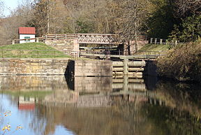
Principal engineer Thomas Oakes Construction began 1815 Date completed 1827 Date closed 1947 Maximum boat length 110 ft 0 in (33.53 m) Maximum boat beam 18 ft 0 in (5.49 m) (originally 13 ft 0 in (3.962 m))
(Size of Lock 60)Start point 40°34′42″N 76°01′35″W / 40.57833°N 76.02639°W (originally 40°41′37″N 76°09′52″W / 40.69361°N 76.16444°W)
(18 miles (29 km) above Port Clinton abandoned by December 1887)End point 39°58′02″N 75°11′16″W / 39.96722°N 75.18778°W Locks 44 (originally 72)
Length 90 miles (140 km) (originally 108 miles (174 km))
Maximum height above sea level 618.75 ft (188.60 m)
(above mid tide of Delaware River)Status Mostly infilled Schuylkill Navigation Canal, Oakes Reach Section

Nearest city: Phoenixville, Pennsylvania Coordinates: 40°07′57″N 75°30′09.5″W / 40.1325°N 75.502639°W Area: 155.3 acres (62.8 ha) Built: 1821 Architect: Thomas Oakes Governing body: State NRHP Reference#: 88000462
[1]Added to NRHP: May 06, 1988 Schuylkill Canal is the common, but technically inaccurate, name for the Schuylkill Navigation, a 19th-century commercial waterway in and along the Schuylkill River in the U.S. state of Pennsylvania. The "canal" was actually a system of interconnected man-made canals and slack-water pools in the river, which is called a navigation. The Schuylkill Navigation System opened in 1825 to provide transportation and water power. At the time, the river was the cheapest and most efficient method of transporting bulk cargo. As a result of this improved transportation, anthracite coal-mining grew as the major source of industry between Pottsville and Eastern markets. Mules pulled barges of coal from Port Carbon to Pottsville; to the ports of Philadelphia; and, continuing through additional waterways, to New York City markets.
The canal eventually declined due to the rise of rail transport, and was almost completely filled in the 1950s. The two remaining watered reaches are now used for recreation.
Contents
History
The Schuylkill Navigation Company was chartered in 1815 to build a series of navigation improvements in the Schuylkill River. A waterway of 108 miles (174 km) was completed in 1827 linking Philadelphia to Port Carbon in the anthracite coal fields or the Coal Region of Pottsville. Combining 62 miles (100 km) of separate canals, often referred to as "reaches", with 46 miles (74 km) of slack water pools, the Schuylkill Navigation used 92 lift locks to overcome a difference of 588 feet (179 m) in elevation between its terminal points. The Union Canal, built between 1821 and 1828, connected with the Schuylkill Canal at Reading; the two canals combined to make a water link between Philadelphia and the Susquehanna River at Middletown. This route competed with and became secondary to the east–west divisions of the Pennsylvania Canal on the Main Line of Public Works between Philadelphia, Harrisburg, and Pittsburgh. The Schuylkill Canal also featured the first transportation tunnel in America.[2] The Auburn Tunnel, a 450 foot (137 m) bore through a hill near Auburn, was completed in 1821, but due to increased traffic, canal modifications turned it into an open-cut by 1857.[3]
 Schuylkill Canal (starting at Philadelphia) with other US canals of 1825
Due to its ability to transport bulk cargoes and provide water power, the Schuylkill Navigation transformed the towns of Reading, Norristown, and Pottsville into early manufacturing centers. By using the Delaware River and the Delaware and Raritan Canal, manufactured products and anthracite from the Schuylkill Valley could also reach New York Harbor. The Schuylkill Navigation system quickly assumed a monopoly position in the transportation of anthracite coal from the coal mines of Schuylkill County to Philadelphia. By 1841 the Schuylkill Navigation was annually transporting over 737,517 tons of cargo. However, in 1841 the Philadelphia and Reading Railroad was completed as a competing means of transporting coal from the Schuylkill anthracite fields to Philadelphia. A rivalry between these two forms of transportation soon developed.
Competition with the railroad
By 1845 the railroad was able to haul three times as much anthracite to Philadelphia each year as the Schuylkill Navigation. To counter this threat, the Schuylkill Navigation Company began a major expansion program. By 1847 the canals had been enlarged to allow the passage of boats carrying 230 tons of coal. In 1850 a price-fixing arrangement with the railroad stabilized prices for the transportation of anthracite. This decade was the Schuylkill Navigation's most prosperous period, transporting 1,700,000 tons of cargo during the peak year of 1859. However, in that same year the Philadelphia and Reading Railroad carried over 2,500,000 tons.
Decline
During the 1860s the canal entered a period of decline. In 1869 it was damaged by a flood. Surrendering to the competition in 1870, the Schuylkill Navigation Company leased its waterway to the Philadelphia and Reading Railroad for a period of 110 years. Under the railroad's control, the Schuylkill Navigation continued to decline. Since the Delaware and Raritan Canal was owned by the competing Pennsylvania Railroad, Schuylkill boats were denied access to this important New Jersey waterway. As a result, traffic on the Schuylkill decreased rapidly. Adding insult to injury, the PRR itself invaded the Schuylkill's territory with the construction of its Schuylkill Branch in the mid-1880s. By 1890 only 144,994 tons of cargo passed through the Schuylkill Navigation. The Schuylkill Navigation was also greatly hindered by the problems of coal silt deposits which made its upper sections almost unusable. By 1891 the portion of Navigation above Port Clinton was abandoned. By 1904 the anthracite traffic had almost completely ceased, and after 1913 only an occasional cargo passed between Port Clinton and Philadelphia. Excursion vessels and pleasure boating remained active on the Schuylkill Navigation until most of the canals were filled by the Commonwealth of Pennsylvania during 1947–1979 in efforts to remove coal silt from the Schuylkill River.
Chester County Canal
The Chester County Canal, also known as the Phoenixville Branch Canal,[4] was an addition to the Navigation built by the Schuylkill Navigation Company in 1828 to provide water power to a new nail works in Phoenixville. The new canal connected the slackwater pool of the Schuylkill Canal above the Black Rock Dam to Phoenixville. This canal paralleled the top end of the Oakes Reach, on the opposite side or the river. While the Chester County Canal was initially built to provide water power to the mill, in 1847 it carried scheduled passenger service between Phoenixville and Norristown.[5] The spring freshet of 1869 destroyed the mill "and very much injured the canal and its locks."[6]
While many of the dams remain, there are only two watered stretches of the canal still in existence. Some 2.5 miles (4.0 km) of the original 3.5 miles (5.6 km) long Oakes Reach between Oaks and Mont Clare and the 1 mile (1.6 km) reach in Manayunk. Ruins and remnants of the canals structure are still visible along its length. Many of the locks chambers still exist but are buried to varying degrees. Some of the locktender's houses still exist. Even if filled in, the canal's presence in may river communities is remembered by several Canal Streets.
Leesport has a restored Locktender's house on E. Wall Street. The adjacent lock is filled in, but the SW corner and top of the chamber are visible. Near Gibraltar, the Allegheny Creek Aqueduct still exists along with a drained section of the canal prism. The Aqueduct is on the National Register of Historic Places.
Oakes Reach
 Lock 60 miter gates and tow path bridge after their 2004-5 restoration.
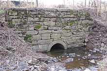 Canal aqueduct over Crossman's Run, near Oaks
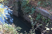
The head of the Oakes Reach is at the Black Rock Dam (Dam #26), near Mont Clare. The canal passes through the dam structure at Lock #60. The volunteer Schuylkill Canal Association has restored Lock 60 to operating condition [1]. The nearby locktender's house has also been restored [2]. The Reach runs under Pennsylvania Route 29 in Mont Clare, directly across the river from Phoenixville, then through Port Providence. An impounding basin from the silt removal project cuts the canal after Longford Road and the final mile of the Reach, has been filled in. An old stone aqueduct, that carried the Canal over Crossman's Run, and the outlet lock tender's house are still existent; but Lock 61, Brower's Lock, was filled in.
This reach is named for Thomas Oakes, chief engineer of the Schuylkill Navigation Company. The Oakes Reach canal, locks, locktenders' houses, Black Rock Dam, and the slackwater pool extending up to the Pennsylvania Route 113 bridge form the "Schuylkill Navigation Canal, Oakes Reach Section" historic district.
- Lock 60 40°08′42″N 75°30′28″W / 40.145°N 75.50778°W
- Present end of reach 40°07′42″N 75°28′57″W / 40.12833°N 75.4825°W
- Lock 61 Tender's House 40°07′34.6″N 75°27′40.9″W / 40.126278°N 75.461361°W
Manayunk Reach
 Remains of Lock 70 at the outlet of the Manayunk Reach
 Manayunk Reach, a very industrial section of the Navigation
The head of the Manayunk Reach is at the Flat Rock Dam (Dam 31), near Shawmont. The canal originally passed through the dam structure at Lock 68. However Lock 68 is plated off, and the area above has filled in. This stretch of canal forms the northern side of Venice Island, which is facing development pressures. At the downstream end of this reach, the canal runs through Manayunk and returns to the river via Locks 69 & 70. All three lock structures still exist.
- Lock 68 40°02′17″N 75°14′40″W / 40.03806°N 75.24444°W
- Locks 69&70 40°01′22″N 75°13′11.5″W / 40.02278°N 75.219861°W
Schuylkill River Trail
The Schuylkill River Trail (SRT) now overlays portions of the canal route. In Manayunk, the Trail was constructed across the canal from the towpath. (The Reading railroad built a freight spur on the canal towpath. That railroad is still served by Norfolk Southern).
In 2008 the extension of the Schuylkill River Trail from the Perkiomen Creek to Longford Road in Oaks opened. This length of the Trail makes use of the general course of the filled portion of the Oakes Reach and originally used the old canal aqueduct to cross Crossman's Run. On 14 February 2008, a meeting was held to announce the survey work for the extension of the Schuylkill River Trail along the towpath of the watered portion of the Oakes Reach. It was expected that the towpath restoration itself would commence around March 2009.[7] However this work was suspended due to budget constraints.
-
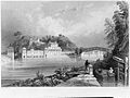
"Schuylkill Waterworks" (1835), with Schuylkill Canal in the foreground.
-

Locks on Schuylkill Canal.
-

Bridge over Schuylkill Canal.
-

Mouth of the Schuylkill Canal, below Fairmount Dam, Philadelphia. The Wire Bridge (background) stood at the site of the current Spring Garden Street Bridge.
See also
References
- ^ "National Register Information System". National Register of Historic Places. National Park Service. 2007-01-23. http://nrhp.focus.nps.gov/natreg/docs/All_Data.html.
- ^ "The Schuylkill and Transportation". Archived from the original on 2007-08-09. http://web.archive.org/web/20070809015226/http://www.web-savvy.com/river/schuylkill/transportation.html. Retrieved 2008-01-13.
- ^ "American Canal Society Canal Structure Inventory - Auburn Tunnel". http://www.americancanals.org/Pennsylvania/Auburn%20Tunnel.pdf. Retrieved 2008-11-29.
- ^ "Exelon - Black Rock Dam and its history". http://www.exeloncorp.com/corpresponsibility/environment/blackrock/brdhistory.htm. Retrieved 2009-11-16.[dead link]
- ^ Pennypacker, Samuel Whitaker (1872). Annals of Phoenixville and Its Vicinity: From the Settlement to the Year 1871. Philadelphia: Bavis & Pennypacker, printers. p. 176. http://books.google.com/books?id=pfcMAAAAYAAJ.
- ^ Pennypacker, p. 168
- ^ "Schuylkill Canal Towpath Restoration Project". http://trails.montcopa.org/trails/cwp/view,a,1454,q,62259.asp. Retrieved 2008-03-15.
External links
- Schuylkill Navigation History, description and list of locks, dams, and reaches
- Historical Berks county and the Schuylkill Canal
- Lower Schuylkill River canal
- Historical pictures of the Schuylkill Canal
- Schuylkill Navigation Collection at Reading Area Community College
- Upper Schuylkill River canal
- Friends of the Manayunk Canal - Manayunk Reach
- Schuylkill Canal Association - Oak[e]s Reach
- PA Historical Marker and information
- NRHP Registration Form for Oakes Reach - Use search form on PA ARCH site for additional image
- Information and pictures of the Schuylkill Canal in Schuylkill Haven, PA
Categories:- Historic districts in Pennsylvania
- Buildings and structures on the National Register of Historic Places in Pennsylvania
- Canals in Pennsylvania
- Schuylkill River
- Canals on the National Register of Historic Places
- Ruins in the United States
- Transportation in Pennsylvania


Wikimedia Foundation. 2010.